Showing 2304 items matching "parishes"
-
 Federation University Historical Collection
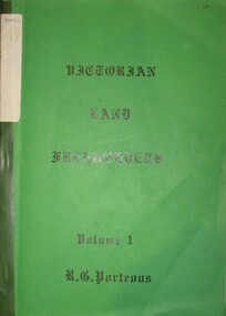
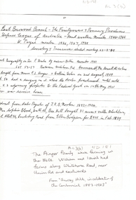
Book, Roger G. Porteous, Victorian Land Freeholders
Green soft covered book with green tape spine. The book includes names and dates of the first land freeholders listed on Ballaarat and district Parish Maps. -
 City of Moorabbin Historical Society (Operating the Box Cottage Museum)
Pamphlet - St Finbar's Parish Church, East Brighton - Celebrating 150 Years 1848-1998, 1998
St Finbar's Roman Catholic Church corner of Nepean Highway and Centre Road, East Brighton.St Finbar's Roman Catholic Church East Brighton was erected in 1871 and was integral to the spiritual well being and social life of the early settlers.Four page AO5 brochure inviting people to join in historic 150 year celebration. Contains brief history of the Parish of St Finger's East Brighton.early settlers, parish of moorabbin, city of moorabbin, county of bourke, shire of moorabbin, were j.b., market gardeners, nepean highway, east brighton, st finbar's parish, centre road, religion, roman catholic -
 Bendigo Historical Society Inc.
Map - JACK FLYNN COLLECTION: KARA KARA, 1932
Map: County of Kara Kara, map sheet showing the whole of the County of Kara Kara and all of the Parishes within. Scale 2 miles to 1 inch.By Authority: W.M. Houston, Government Printer Melbourne. Department of Lands and Survey, Melbourne, 1958map, kara kara, county, kara kara -
Bendigo Historical Society Inc.
Map - SUTTON GRANGE, 10th July 1872
Map: Residence sites at Sutton Grange, being subdivision of Allotment 10 Sec. 3, Parish of Sutton Grange (number 275 in map cupboard 1)map, subdivision, sutton grange, residence sites, allotment 10 sec. 3 -
 Victorian Aboriginal Corporation for Languages
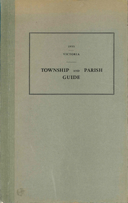
Book, Department of Crown Lands and Survey Victoria, Township and parish guide : Victoria, 1955
A alphabetical list of townships proclaimed under the Land Acts of Victoria. Shows the parish, land district and the municipality in which each is situated, and the particulars of Gazettal of Proclamation.victorian geographical names, victorian administration -
Whitehorse Historical Society Inc.
Article, Rayner Charges Fail, Resume, 14/02/1997
Archbishop Peter Carnley issues statement regarding charges brought against the Archbishop of Melbourne by the Reverend David Greentree re the Parish of St. Lukes, Vermont.st. lukes anglican church, vermont, greentree, david (rev), carnley, peter -
 Whitehorse Historical Society Inc.
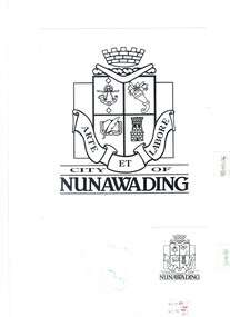
Artwork, other - Illustration, Original Coat Of Arms, 1/02/1993
Original art work for the Coat of Arms for the City of Nunawading. Accompanied by letter from Karen Parish, the designer. 3 pages within cardboard protective cover.city of nunawading, parish karen, coat of arms -
 Bendigo Historical Society Inc.
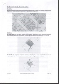
Document - History of 11 Mackenzie Street
Bendigo Historical Society moved into 11 Mackenzie Street, Bendigo in 2022. The BHS Collection has been installed in the building.Six-page history of the ownership of the property at 11 MacKenzie Street, Parish of Sandhurst, Bendigo from subdivision in 1894 to sale in 2021. through five owners. mackenzie street, historical society -
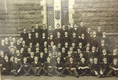 St Patrick's Old Collegians Association (SPOCA)
Photograph - Students, 1910s
-
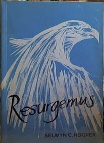 Camberwell Historical Society
Book, Selwyn C. Hooper, Resurgemus: History of St John's Camberwell 1955-1988, 1988
History of the Parish church of St John, Camberwell from 1955, after the destruction of the old church. Published 1988. Contains black and white photographs and illustrations.camberwell, church -
Lakes Entrance Historical Society
Book, Bombala and Districts Historical Society, Backyard History, 1993
A history of Bombala Shire New South Wales and district from official records parish plans, and anecdotes, produced for research purposes only. Illustrated with maps.settlers, township, genealogy -
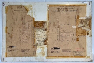 Greensborough Historical Society
Poster - Planning Document, City of Heidelberg et al, Subdivision Plan # 5 - Crown Portion 17, Parish of Nillumbik, and Crown Portion18, Parish of Keelbundoora, 1925-1972
Subdivision Plan # 5 - Side 1: Crown portion [unknown - damaged], Parish of Nillumbik, Springfield Street, Turner Street Briar Hill,1963 amended 1972 and Crown Portion17, Parish of Keelbundoora: Thoona Grove, Donald Street. Paterson Crescent Greensborough, 1963 amended 1967. Side 2: Parish of Keelbundoora, Crown Portion 18: Boyd Street, Kempston Street Greensborough 1925; and Main Street Greensborough. An example of hard copy subdivision plans from the Greensborough area. Mainly from the Shire of Diamond Valley era (1964-1994).Plan (2 sided) mounted on heavy card. Stamped and handwritten Council permissions, dates and other details.subdivision plans, city of heidelberg, greensborough, briar hill, main street greensborough -
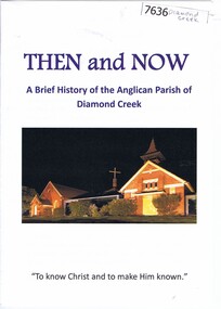 Greensborough Historical Society
Booklet, Nillumbik Historical Society, Then and now: a brief history of the Anglican Parish of Diamond Creek, 22/10/2019
A history of the Anglican Parish of Diamond Creek, prepared for the Yarra Plenty Regional Library's "Diamond Valley History Tour 2019". The Diamond Creek parish includes St John's Diamond Creek, St Michael's Yarrambat and St Katherine's St Helena.Booklet, 8 pages, text and colour illus.diamond valley, yarra plenty regional library, anglican parish of diamond creek, st john's diamond creek, st katherine's st helena, st michael's yarrambat -
Glen Eira Historical Society
Document - St David’s Uniting Church, Glen Huntly
Order of service for the induction of Rev. K Moorhead into the Parish of Glen Huntly 19/01/1984 Order of service for the celebration of the life of Ronald. Henry Summers 1921 – 1999 at St David’s Uniting Church, Glen Huntly, dated June 08/06/1999. Reprinted service of holy communion for Glen Huntly Uniting Parish date unknown. Pamphlet, including photograph of St David’s Uniting Church Parish of Glen Huntly, for the rededication of the Peace Memorial. Pipe organ; for the uniting of the Congregational Methodist and Presbyterian in the Glen Huntly Parish. Reprinted leaflet, with order of service for re-dedication of organ at St David’s 03/03/1985.moorhead kenneth h rev., st david’s uniting church., glen huntly, hunkin edward rev., grange road, waters r rev., rayment rosalie rev, stuart-murray j. dr., duke s. mrs., wallis ken, denholm robin rev., summers ronald henry, gray robin dr., roach harry, roach rene, purcell mr., purcell mrs., stephen cathy, harkness jeff, funston neil, funston robin, sypott e., neerim road, hutchison a, rosedale avenue, barnes peter, fenton r, rockell d, clarke j miss, ness p miss, osborne ivy miss, brownbill jim, courtnay s., fenton leo, johnston e, leather t, moyle b, ness r, peden a, pregnell max, rockell d., jones a., halls, uhe mrs., milligan m miss, chapman may, choirs, abhaywickrema m, theobald j, jones f, abhaywickrema p, riegelhuth j, riegelhuth j, bates t, bates l, ballantyne m, kuhn m, kite l, cameron m, hoare j, roach r, avery d, holmes j, havie j, chapman m, brownbill ella, barren b, pregnall joy, hearn edward henry, toolambool road, mcintyre ted, moyle jenny, avery daisy, powney maisie, vertigan olwyn, dawson harry, davidson eileen, mitchell mabel, mccowan roger, wright lyn, yeaman j, courtnay j, smith j, yeaman d, fenton s, jones f, penfound j, wright l, lord e, brownbill j, brownbill e, hunter j, mitchell m, barren b, moores e, donaldson j, coulson o, moyle b, johnston e, peden a, osbourne i, mccowan r, waters r rev, duke s mrs., adam a. j. rev, hewitt john, davis lyle, organs, cowan john n, organists, scotland betty, musicians, vertigan earle l rev., muirhead j, andrewartha c. w., lomas chas., foundation stone, anderson george rev., fraser finley dr., hadley s. c. rev., simon r. p., mcnair mr, fender mr, forster k rev., flynn john dr., vertigan s. a. rev., muirhead j, smith a.w.f., glen huntly plant nursery, alcock bruce, callen graeme, murrumbeena, neerim road -
Glen Eira Historical Society
Document - COATESVILLE UNTING CHURCH CORNER NORTH AND MACKIE ROAD
Two items about this church: 1/Photocopied details of the Church’s preliminary stages of development at Coatesville Uniting Church. 2/Photocopied article with brief details of Coatesville parish history which includes East Bentleigh Presbyterian and South Oakleigh Methodist parishes.south oakleigh methodist church, reid a, north road, coatesville uniting church, bray mr, mackie road, harris mr, phillips l.g. rev, okey mr, adams mr, williams w.j. rev, murrumbeena, harris mr, iliffe w.r, hallibone mr, fielding mr, reynolds mr, nancarraw mr, reic a mr, thomas miss, winter mr, lanym a. mr, sturgess h mr, sturgess mrs, duncan annie, duncan gordon, sturgess edith, evans chas, ralton mr, architects, coatesville parish, uniting church, east bentleigh presbyterian church, cecil street, peerman alex rev, east bentleigh presbyterian, market gardens, st christopher’s church, bell a.f. rev, body alan rev, jassa street, manses, trevorrow mr, halls, sunday schools, bentleigh east -
Ringwood and District Historical Society
Descriptive Essay, Eddie Russell, The Parish of Ringwood by Eddie Russell July 3, 2011 (5 pages), 03/07/2011
Descriptive essay on history and current day visit to Ringwood summarised for St Paul's Church by Eddie Russell, entitled The Parish of Ringwood. Dated July 3, 2011. -
Bendigo Historical Society Inc.
Map - CAMPBELL COLLECTION: BENDIGO AND DISTRICT MAPS
Map. Mandurang, Parish of Mandurang. Scale 20 chains to 1 inch. Total area 5993 acres. Northern Railway. (number 395 in map cupboard 1)map, bendigo, allotments -
Bendigo Historical Society Inc.
Map - CAMPBELL COLLECTION: BENDIGO AND DISTRICT MAPS
Map. Lyell, Parishes of Sedgwick, Eppalock and Lyell. Scale 20 chains to 1 inch. Total area 3307 acres. (number 387 in map cupboard 1)map, bendigo, country lands -
Bendigo Historical Society Inc.
Map - BENDIGO SHEET 2, No date visible
Map: Parish plan showing portion of Bendigo city, West from the Echuca rail line, showing lake weeroona ( number 136 in Map Cupboard 1)map, bendigo, city streets, bendigo sheet 2, bendigo streets -
Bendigo Historical Society Inc.
Map - BAMAWM ESTATE, 12/.08/1912
Map: Bamawm Estate, Acquired under Closer settlements Acts 1904, County of Bendigo. Parish Plan Canvas backed. ( number 130 in Map Cupboard 1)map, bendigo, rural, bamawm estate, closer settlement acts 1904, county of bendigo -
Bendigo Historical Society Inc.
Map - BAMAWM ESTATE, 24/02/1931
Map: Bamawm Estate, Aquired under closer settlement Act 1904, County of Bendigo. Parish plan Canvas backed ( number 129 in Map Cupboard 1)map, bendigo, rural, bamawm estate, closer settlement acts 1904, county of bendigo -
Bendigo Historical Society Inc.
Map - BEAR'S LAGOON, 2/10/1931
Map: Town of Munica ( name crossed out and Bear's Lagoon hand written in), Parish of Janiember east, County of Bendigo ( number 151 in Map Cupboard 1)map, bendigo, township, bear's lagoon, munica, janiember east, county of bendigo -
Bendigo Historical Society Inc.
Map - SANDHURST (PART), Circa 1880's
Map: Parish plan covering the area from Belle Vue Rd. to Barnard St. and Maple St to Short St. ( number 230 in Map Cupboard 1)map, bendigo, parish plan, sandhurst, belle vue road, barnard street, maple street , short street -
Bendigo Historical Society Inc.
Map - BENDIGO (SANDHURST) PART, No date visible
Map: Parish plan showing an area North West from the McKenzie St. View St. corner to Long Gully ( number 220 in Map Cupboard 1)map, bendigo, parish plan, bendigo, long gully -
Bendigo Historical Society Inc.
Map - BENDIGO, issued 1st January 1906
Map: Sketch map of Bendigo, including Eaglehawk and the Parish of Sandhurst. Issued by the Fire Underwriters Association of Victoria. Revised copy (number 317 in map cupboard 1)map, bendigo, city streets, map of bendigo, fire underwriters association of victoria -
Whitehorse Historical Society Inc.
Legal record - Land Title, Certificate of Title, 1919
Lots 21 and 22 on Plan of Subdivision no. 6149 Crown Portion 89, Parish of Nunawading vol. 4192 fol. 838287, owned by State Savings Bank of VictoriaLots 21 and 22 on Plan of Subdivision no. 6149 Crown Portion 89, Parish of Nunawading vol. 4192 fol. 838287, owned by State Savings Bank of VictoriaLots 21 and 22 on Plan of Subdivision no. 6149 Crown Portion 89, Parish of Nunawading vol. 4192 fol. 838287, owned by State Savings Bank of Victoriablackburn road blackburn, walsham road blackburn, state savings bank of victoria -
Whitehorse Historical Society Inc.
Pamphlet, All Saints Church Paper, 01/08/-/09/1973 - 1974
Parish papers of All Saints Church, Nunawading.Parish papers of All Saints Church, Nunawading, mentioning the dedication of memorial music cabinet to the memory of Florence Lillian McCall and Vicar's notes on the new Memorial Garden.Parish papers of All Saints Church, Nunawading. all saints anglican church nunawading, mccall, florence lillian -
 Whitehorse Historical Society Inc.
Map, Frank Ainger, 1873
Application by Frank Ainger for land in the Parish of Nunawading on Whitehorse Road near Mitcham Road. Also included are several references from other sources to Frank Ainger.ainger, frank, shire of nunawading, mitcham, land settlement -
Bendigo Historical Society Inc.
Newsletter - LYDIA CHANCELLOR COLLECTION: UNITING CHURCH IN AUSTRALIA SOUTH BENDIGO PARISH MONTHLY MAGAZINE, 1979
LYDIA CHANCELLOR COLLECTION: UNITING CHURCH IN AUSTRALIA SOUTH BENDIGO PARISH MONTHLY MAGAZINE February 1979 For the Golden Square, Lockwood and Kangaroo Flat Uniting churches.bendigo, history, churches -
 Bacchus Marsh & District Historical Society
Map, Bacchus Marsh Region Parish Plans: Folded set of maps
Set of Victorian Lands Department Parish Plans covering the township of Bacchus Marsh and surrounding districts. Folded. BMDHS Location: AR/SU27/D2: Map Drawersmaps bacchus marsh region, bacchus marsh victoria maps, interim record