Showing 1793 items matching "railway map"
-
 Bendigo Historical Society Inc.
Map - LEICHARDT : COUNTY OF BENDIGO, 15-6-19
Map. Leichardt, County of Bendigo, Bridgewater, Yarraberb, Nerring, Marong, Woodstock, Derby, Sandhurst & Inglewood Railway Line. Photo-Lithographed at the Department of Lands and Survey, Melbourne, by T.F. McGauran, 15-6-09. Price 1/-. (number 68 in map cupboard 1)T.F. McGauranmap, bendigo, leichardt -
Bendigo Historical Society Inc.
Map - CAMPBELL COLLECTION: BENDIGO AND DISTRICT MAPS
Map. Eaglehawk, Parishes of Huntly and Nerring. Scale 20 chains to 1 inch. Total area 6211 acres. Eaglehawk Kerang Railway, to Epsom 2 miles. Manure Depot. (number 390 in map cupboard 1)map, bendigo, allotments -
Bendigo Historical Society Inc.
Map - CAMPBELL COLLECTION: BENDIGO AND DISTRICT MAPS
Map. Eaglehawk, Parishes of Huntly and Nerring. Scale 20 chains to 1 inch. Total area 6211 acres, Bottom left is Eaglehawk Kerang Railway line. IN PENCIL Euc areas 1974, Laurie C.Raynor Comp 13,14,15. J & T Pierce 1,9,8. The use of sticky tape on joins. Sand heaps from Moon Mine. (number 369 in map cupboard 1)map, bendigo, allotments -
Bendigo Historical Society Inc.
Map - CAMPBELL COLLECTION: BENDIGO AND DISTRICT MAPS, 8-7-29
Map. Rifle Range, Parishes of Wellsford and Sandhurst. Scale 20 chains to 1 inch. Total area by Planimeter 5916 acres. Wallan and Bendigo Railway line. Rifle Range. Axedale township and station 8 miles. To Longlea Ryl station 2 1/2 miles. To Epsom 1 1/2 miles. To Bendigo 3 miles. Compiled in W.P.D. from Assessment and Parish Plans by H.A.D 8-7- 29 (number 367 in map cupboard 1)H.A.D.(H.A.Darby)map, bendigo, allotments -
Bendigo Historical Society Inc.
Map - CAMPBELL COLLECTION: BENDIGO AND DISTRICT MAPS
Map. Ascot Unit, scale 20 chains to an inch, arrow pointing to magnetic north, road to Fosterville to the East, Huntly 3/4 mile to the West, road to Epsom 3/4 mile and road to Bendigo 4 1/2 miles south west on map, also on page is the Northern Railway (Bendigo to Echuca) line. (number 355 in map cupboard 1)map, bendigo, country lands -
 Bendigo Historical Society Inc.
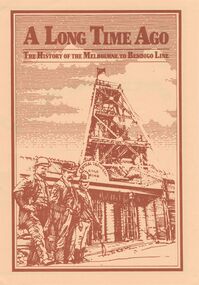
Document - A LONG TIME AGO: THE HISTORY OF THE MELBOURNE TO BENDIGO LINE
'A LONG TIME AGO: THE HISTORY OF THE MELBOURNE TO BENDIGO LINE' Bi-fold publication. A schematic 'strip' map of the line with particular places (approx 40) marked on the route with short descriptions of these sites. Concise description of the construction of the line; a summary of present attractions for the visitor to Bendigo and V/Line information.Walker Printing Bendigorailways, bendigo to melbourne, brochure, barkers creek , harcourt, elphinstone tunnel, malsmbury, malmsbury viaduct, kyneton, carlsruhe, hanging rock, woodend, mount macedon, riddells creek, clarkefield hotel, rupertswood, sunbury, diggers rest, sydenham, st albans, spencer street. v/line. -
 Bendigo Historical Society Inc.
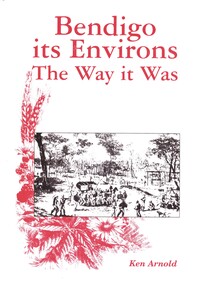
Book - BENDIGO ITS ENVIRONS THE WAY IT WAS, 2003
Bendigo its Environs The way it Was. A brief history of Bendigo & surrounding areas & of the water supply and railway line to Bendigo & surrounds. Contains 432 pages with photographs, illustrations and maps, published by Crown Castleton.Ken Arnoldbendigo, history, bendigo & district, signed by author, limited edition number 175 -
 Bendigo Historical Society Inc.
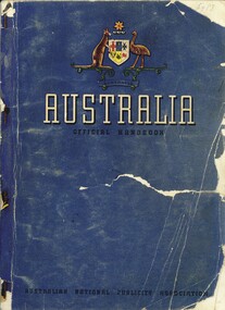
Book - AUSTRALIA OFFICIAL HANDBOOK, 1941
Australia Official Handbook, a publication issued with the authority of the minister for commerce by the Australian National Publicity Association, Railway Building Flinders St Melbourne telling the story of the progress and development of Australia. Contains 140 pages with black & white photographs, illustrations & colour maps. Dark blueAustralian National Publicity Assocaustralia, history -
 Bendigo Historical Society Inc.
Book - V.R. GRADIENTS & CURVES
V.R. Gradients & Curves. Publisher H J Green, Government Printer, Melbourne. 203 pages. Diagrams of gradients across Victorian rail lines. Maps.Victorian Railwayscottage, miners -
 Bendigo Historical Society Inc.
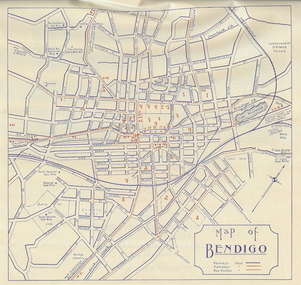
Document - BASIL MILLER COLLECTION: BENDIGO MAP, September 1956
Map of Bendigo with places of interest. Issued by Victorian Railways Public Relations and Betterment Board.person, individual, baby portrait -
 Bendigo Historical Society Inc.
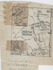
Negative - TOM PATULLO COLLECTION: SEBASTIAN GOLDFIELD
Negative,/Hand drawn of the goldfield featuring gold mine sites,cyanide vats,heaps,railway station,sports ground. A small map of the Whipstick area, and legend. Tom Patullo was formerly of Clear-Ads Bendigo.cottage, miners, sebastian goldfield, sebastian goldfield -
 Bendigo Historical Society Inc.
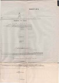
Map - STRUGNELL COLLECTION: UNDERGROUND SURVEY OF MINES BENDIGO
Map, Underground Survey of Mines, Bendigo, New Chum Railway Reef, Shenandoah Co's Shaft, Shamrock Co's Shaft.Young Chum Reef, Thorpe's Reef, Shenandoah Reef, Consolidated Reef, Sheet 3.Survey under the Supervision of H.Herman. Drawing shows mine shafts to over 3100 feet deepmap, bendigo, shamrock & shenandoah co's -
 Bendigo Historical Society Inc.
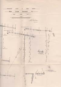
Map - STRUGNELL COLLECTION: UNDERGROUND SURVEY OF MINES, BENDIGO, 25-5-01
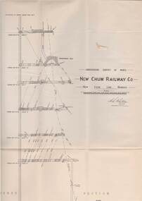
... Bendigo new chum railway co. A.S.Whitelaw Map, Underground Survey ...Map, Underground Survey of Mines, Bendigo, New Chum Railway Co, New Chum Line.A.S.Whitelawmap, bendigo, new chum railway co. -
 Bendigo Historical Society Inc.
Map - STRUGNELL COLLECTION: UNDERGROUND SURVEY OF MINES, BENDIGO, 29-3-01
... Bendigo new chum railway co. A.S.Whitelaw Map, Underground Survey ...Map, Underground Survey of Mines, New Chum Railway Co., New Chum Line, Transverse Section.A.S.Whitelawmap, bendigo, new chum railway co. -
 Bendigo Historical Society Inc.
Map - STRUGNELL COLLECTION: UNDERGROUND SURVEY OF MINES BENDIGO, 27-3-01
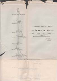
Map, Underground Survey of Mines, Shamrock Co., New Chum Line, Bendigo. Transverse Section, Garibaldi Reef, Young Chum Reef, Thorpe's Reef, Mundic Reef, Shenandoah Reef, New Chum Railway Reef, Surveyed under the Supervision of H.Herman.H.S.Whitelaw.map, bendigo, shamrock co. -
 Bendigo Historical Society Inc.
Map - STRUGNELL COLLECTION: NEW CHUM LINE OF REEF, 5/4/01
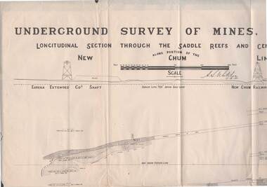
Map, Along portion of the New Chum Line, Underground Survey of Mines, Bendigo, Longitudinal Section through the Saddle Reefs and Centre Country. Eureka Extended Co's shaft, New Chum Railway Co's shaft. Surveyed under the supervision of H.Herman, B.C.E., F.G.S., Acting Government Geologist.H.S.Whitelowmap, bendigo, new chum line -
 Bendigo Historical Society Inc.
Book - RAILWAYS COLLECTION: TRAIN TIMES COUNTRY AND INTERSTATE WINTER ISSUE 1965
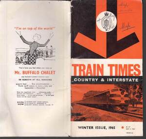
RAILWAYS COLLECTION - Victorian Railways train times country and interstate - winter issue 1965 - as at May 3, 1965 price 6d - glossy cover in orange, black and white showing a Diesel train on the front. Back page has a fold out map of rail routes.railways, bendigo to melbourne -
Bendigo Historical Society Inc.
Map - ELLESMERE : COUNTY OF BENDIGO, 18-1-1943
Map. Ellesmere, County Bendigo, Bagshot, Wellsford, Axedale, Muskerry, Goornong, Bendigo Creek, Bendigo to Echuca- Northern Railway Line, Campaspe River, Sugarloaf Trig.Station. Township of Fosterville.By Authority: H.E. Daw, Govt. Printer, Melbourne. Drawn ad reproduced at the Dept. of Lands and Survey, Melbourne . 18-1-1943.Price 2/-. (number 37 in map cupboard 1)H.E. Daw, Government Printer, Melbourne.map, bendigo, ellesmere -
Bendigo Historical Society Inc.
Map - ELMORE : COUNTY OF BENDIGO, 4-7-18
Map. Elmore, County of Bendigo, Diggorrra, Burnewang, Runnymede, Nolan, Egerton. Township of Elmore. Campaspe River. Northern Railway Line. Photo-Lithographed at the Department of Lands and Survey, Melbourne by W.J. Butson, 4-7-18.Price 1/-. By authority A.J. Mullett, Govt. Printer. (number 36 in map cupboard 1)A.J. Mullett, Govt. Printer.map, bendigo, elmore -
Bendigo Historical Society Inc.
Map - TARNAGULLA : COUNTY OF BENDIGO, 13-5-22
Map. County of Bendigo, County of Gladstone.Inglewood, Glenalbyn, Kingower, Moliagul, Waanyarra, Laaneoorie, Woodstock, Loddon River, Township of Tarnagulla, Township of Newbridge, Township of Llanelly, Dunolly to Inglewood Railway, Tarnagulla Rifle Range, Laurie Station, Bullabul Creek, Arnold Township, Arnold Railway Station. Photo-Lithographed at the Department of Lands and Survey, Melbourne by W.J. Butson, 13-5-22.Price 1/-.By authority A.J. Mullett, Government Printer, Melbourne. (number 118 in map cupboard 1)A.J. Mullett, Government Printer, Melbourne.map, bendigo, tarnagulla -
 Bendigo Historical Society Inc.
Book - THE RAILWAY RIOTS
The Railway Riots, Kyneton Historical Society Inc, 52 pages with photographs and maps, includes background history & opening of the Kyneton Railway Station 1862Larina. M. Strauchbook, rural, railway -
Bendigo Historical Society Inc.
Map - CAMPBELL COLLECTION: BENDIGO AND DISTRICT MAPS, 21-8-1972
Map. Shire of Strathfieldsaye Locality Plan. Scale 1 inch=1 mile. Drawn by M.Higgs 21-8-1972, Shire of Huntly, Shire of McIvor, City of Bendigo, Shire of Marong, Shire of Maldon, Shire of Metcalfe, Lake Eppalock, Axedale Township, Strathfieldsaye Township, Melbourne to Bendigo Railway Line, Big Hill Tunnel, Mt.Herbert 1596. (number 398 in map cupboard 1)M.Higgs 21-8-1972map, bendigo, locality plan -
Bendigo Historical Society Inc.
Map - AXEDALE, COUNTIES OF BENDIGO & RODNEY, 1961
Map, Axedale, Counties of Bendigo & Rodney.Axe Creek, Campaspe River, Longlea Railway Station, Axedale Railway Station, Wallan & Bendigo Railway.Township of Axedale. By authority A.C.Brooks, Govt. Printer, Melbourne.Drawn and reproduced at the Dept. of Lands and Survey, Melbournd. Price 1/-. 1961. (number 61 in map cupboard 1)A.C.Brooks, Government Printer, Melbourne.map, bendigo, axedale -
Bendigo Historical Society Inc.
Map - AXEDALE, COUNTIES OF BENDIGO & RODNEY, 8-2-26
Map, Axedale, Counties of Bendigo & Rodney, Wellsford, Strathfieldsaye, Eppalock, Knowsley, Weston, Muskerry, Ellesmere, Town of Axedale, Longlea Railway Station, Axedale Railway Station, Wallan & Bendigo Railway. Campaspe River.Axe Creek. By authority H.J.Green, Govt. Printer. Photo-Lithographed at the Dept. of Lands and Survey, Melbourneby W.J.Butson 8-2-26. Price 1/-. (number 60 in map cupboard 1)H.J.Green, Govt. Printer.map, bendigo, axedale -
Bendigo Historical Society Inc.
Map - DERBY : COUNTY OF BENDIGO, 1959
Map. Derby, County of Bendigo, Inglewood, Tarnagulla, Woodstock, Leichardt, Bridgewater, Loddon River, Bendigo Railway, Calder Highway, Maldon to Bridgewater Road.By authority A.C. Brooks, Government Printer, Melbourne. Drawn and reproduced at the Department of Lands and Survey, Melbourne, 1959. Price 5/-. (number 59 in map cupboard 1)A.C. Brooks, Government Printer, Melbourne.map, bendigo, derby -
Bendigo Historical Society Inc.
Map - DIGGORRA : COUNTY OF BENDIGO, 26-6-36
Map. Parish of Diggorra, County of Bendigo, Parish of Ballendella, Parish of Pannoobamawm, Pannoomilloo, Rochester West, Warragamba, Minto, Egerton, Elmore, Northern Railway to Echuca, Elmore and Cohuna Railway, Township of Elmore. By authority H.J. Green, Govt. Printer. Photo-Lithographed at the Deptartment of Lands and Survey, Melbourne. 26-5-36. (number 58 in map cupboard 1)H.J. Green, Govt. Printer.map, bendigo, diggorra -
Bendigo Historical Society Inc.
Map - DIGGORRA PARISH : COUNTY OF BENDIGO, 6-9-21
Map. Parish of Diggorra, County of Bendigo, Parish of Bamawm, Rochester West, Pannoomilloo, Warragamba, Minto, Egerton, Elmore, Northern Railway, Parish of Ballendella. Elmore /Cohuna Railway. Photo-Lithographed at the Department of Lands and Survey, Melbourne by W.J. Butson, 6-9-21, Price 1/-.. By authority A.J. Mullett, Government Printer. (number 57 in map cupboard 1)A.J. Mullett, Government Printer.map, bendigo, diggorra -
Bendigo Historical Society Inc.
Map - DERBY : COUNTY OF BENDIGO, 1-9-09
Map. Derby, County of Bendigo, Inglewood, Loddon River, Tarnagulla, Woodstock, Leichardt, Bridgewater, Bendigo to Inglewood Railway. Photo-Lithographed at the Department of Lands and Survey, Melbourne, by T.E. McGauran 1-9-09. Price 1/-. (number 55 in map cupboard 1)T.E. McGauranmap, bendigo, derby -
Bendigo Historical Society Inc.
Map - BRIDGEWATER : COUNTY OF BENDIGO, 6-10-27
Map. Bridgewater, County of Bendigo, Inglewood, Salisbury, Derby, Leichardt, Yarraberb, Yarrayne, Bullock Creek, Loddon River, Sandhurst and Inglewood Railway. Photo-Lithographed at the Department of Lands and Survey Melbourne by W.J. Butson, 6-10-27. Price 1/-. (number 53 in map cupboard 1)W.J. Butsonmap, bendigo, bridgewater -
Bendigo Historical Society Inc.
Map - BAMAWM : COUNTY OF BENDIGO, November 1954
Map. Bamawm, County of Bendigo. Sheet 2, Pannoobamawm, Diggorra. Elmore to Cohuna Railway Line. Township of Lockington. By authority W.M. Houston, Government Printer.Drawn and reproduced at the Department of Lands and Survey, Melbourne. November 1954. Price 5/- per sheet. (number 52 in map cupboard 1)W.M. Houston, Government Printermap, bendigo, bamawm