Showing 113962 items matching "road-making"
-
 Surrey Hills Historical Society Collection
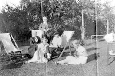
Photograph, Sunday afternoon at 'Dalriada' 77 Union Road, Surrey Hills
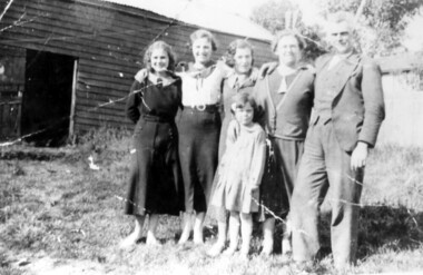
‘Dalriada’” at 77 Union Road, on the corner Bona Vista Avenue has been demolished. It was the home of Mr Charles Henri Dillon Steele, a dentist of Collins Street, his wife Sarah (nee Russell) and daughters Harriette Vevers (Hattie) and Margaret Dillon (Nancy). They are pictured with grandmother Mrs Sarah Ann Vevers Russell (nee Lasslett), who with her husband Alexander lived at 'Clifton', Union Road, Surrey Hills from prior to 1903. He died in 1903 at Clifton. She was still living there in 1919. A black and white photograph of a group of people in their garden, enjoying the sun. The man is standing, two older ladies are sitting on deck chairs and the two younger girls are sitting on the grass playing with a kitten.(mr) charles steele, dalriada, house names, surrey hills, bona vista avenue, (mrs) sarah steele, clothing and dress, union road, (miss) harriette vevers steele, (miss) hattie steele, (miss) nancy steele, (miss) margaret dillon steele, (mrs) sarah ann vevers russell -
 Surrey Hills Historical Society Collection
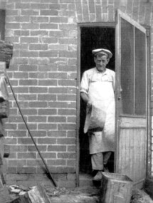
Photograph, Donald Hartley Rowe at his bakery at 118 Union Road, Surrey Hills
The photo is of Donald Hartley Rowe who was a baker at 118 Union Road. The property's rear exited on to Stirling Crescent and this photo was probably taken from kerbside of it. He was born in 1876; married Mary Gibson in 1901 and died in Surrey Hills in 1958. In 1935 his daughter Winifred (1903-1985) married Phillip Sebastien Slavin (1907-1980), known as Paddy, who took over the business. He is first listed at 118 Union Road (no occupation noted) in the electoral roll of 1937 through until 1963.A black and white photograph of a baker, dressed in pants and shirt and wearing a white apron and a light coloured cook's flat cap coming out of a doorway. He has a large tin dish in his right hand.baker, union road, surrey hills, (mr) donald hartley rowe, (miss) winifred rowe, (mrs) winifred slavin, (mr) phillip sebastien slavin, (mr) paddy slavin -
 Greensborough Historical Society
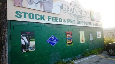
Photograph - Digital Image, Marilyn Smith, Greensborough Grain Store, 183 Para Road, 06/08/2016
This photograph shows the exterior of the building at 183 Para Road when it was used for Greensborough Grain Store; this photo was taken in August 2016, shortly after the owners removed graffiti from the building.In 2017, the Greensborough Grain Store closed its Para Road premises and now trades online.Digital copy of colour photographgreensborough grain store, para road greensborough, graffiti -
 Surrey Hills Historical Society Collection
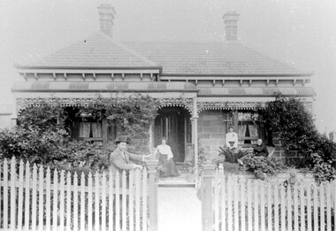
Photograph, "Braemar" 18 Suffolk Road, Surrey Hills
"Braemar" at 18 Suffolk Road, Surrey Hills - built c1894, demolished in1977 – and home of James Sneddon Snr. and family from 1890 until c1950. We believe it is James is at the gate and his family on the veranda. James was born in Alloa, Clackmannanshire Scotland in 1833, as was his wife Jane. He died in March 1901 and she in March 1911. They are buried in Boroondara Cemetery (Pres B0522) with their daughter Jane (1864-1928). James Sneddon (Snr) was an important man in early Surrey Hills. He established real estate and ironmongery businesses in Union Road – first on the corner of Stirling Crescent and later over the road on the corner of Windsor Crescent. He was chairman of Surrey Hills’ MUIOOF (Manchester Unity Independent Order of Oddfellows). James Sneddon Jnr. followed his father in the family real estate business and was an even busier community man. He was a JP and had roles in the Surrey Hills ANA, the Progress Association and the Choral Society. He lived 2 doors from his father. The real estate business continued on the corner of Windsor Crescent and Union Road (north side) until the business was sold to the Doubleday (family) after WW2.The Sneddon family were early settlers and business owners in Surrey Hills and remained over 3 generations. Different family members held many roles in community organisations. This photo is also important in documenting built heritage that has been demolished.Image of a Victorian, weatherboard, block fronted, single storey house with decorative veranda, viewed from the front. The garden in front of the house is well established and a light-coloured picket fence surrounds the property. Four people are in the photograph, three women (two seated and one standing) on the veranda and one male, who is leaning against the gate post.buildings, structures and establishments, houses, timber houses, house names, braemar, architectural styles, victorian style, families, family group, sneddon family, james sneddon (snr), boroondara cemetery, real estate agent, ironmonger -
 Otway Districts Historical Society
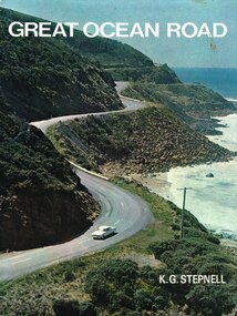
Book, Rigby Limited, Great Ocean Road. K.G. Stepnell, 1972
The Great Ocean Road may be the only road in the world which was built as a war memorial. In 1916, much of Australia was poorly served by roads, and it was suggested that returning servicemen could be given worthwhile employment by building roads in isolated areas. The plan was taken up for the Great Ocean Road, and work was dedicated to the memory of men who had fallen in World War 1. The road itself is a great feat of engineering. It wind around some of Australia's most rugged coastline. Now it is one of the world's most scenic routes, crossing gorges, along precipitous cliffs, through dense forests, and over steeply rolling coastline country.Great Ocean Road. K.G. Stepnell. 1st ed. Rigby Limited; Adelaide (S.A.); 1972. 36 p.; illus., maps. Hard cover. ISBN 0 85179 371 1great ocean road; roads; fishing; timber; twelve apostles; -
 Marysville & District Historical Society
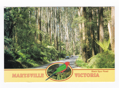
Postcard (item) - Colour postcard, Neil Cutts, Marysville Victoria-Black Spur Road, Pre 2009
A postcard in a series produced by the Rose Stereograph Company in Victoria, Australia as a souvenir of Marysville.A colour photograph of the Black Spur Road near Marysville in Victoria. The Black Spur is known to be one of Victoria's most scenic drives. The road winds through a majestic forest of trees and tree ferns from Healesville to Narbethong and is part of the Maroondah Highway. Rose Series postcard No. 3528. POST CARD The "Rose" Series/ De Luxe Proudly Printed in/ Australia Since 1880 AFFIX/ STAMP/ HERE/ Rose Series/ Post Card No./ 3528 ADDRESS/ POSTCODE Mountain Ash and Treeferns/ Black Spur Road/ MARYSVILLE, VICTORIA, AUSTRALIA/ Photo Neil Cutts Copyright Rose Stereograph Co., Glen Waverley, Victoria (03) 9560 7772marysville, victoria, black spur road, postcard, souvenir, rose series postcard, 3528, healesville, narbethong, maroondah highway -
 Marysville & District Historical Society
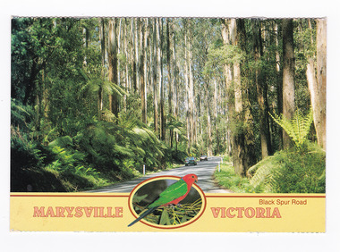
Postcard (item) - Colour postcard, Neil Cutts, Marysville Victoria-Black Spur Road, Pre 2009
A postcard in a series produced by the Rose Stereograph Company in Victoria, Australia as a souvenir of Marysville.A colour photograph of the Black Spur Road near Marysville in Victoria. The Black Spur is known to be one of Victoria's most scenic drives. The road winds through a majestic forest of trees and tree ferns from Healesville to Narbethong and is part of the Maroondah Highway. Rose Series postcard No. 3528. POST CARD The "Rose" Series/ De Luxe Proudly Printed in/ Australia Since 1880 AFFIX/ STAMP/ HERE/ Rose Series/ Post Card No./ 3528 ADDRESS/ POSTCODE Mountain Ash and Treeferns/ Black Spur Road/ MARYSVILLE, VICTORIA, AUSTRALIA/ Photo Neil Cutts Copyright Rose Stereograph Co., Glen Waverley, Victoria (03) 9560 7772marysville, victoria, black spur road, postcard, souvenir, rose series postcard, 3528, healesville, narbethong, maroondah highway -
 Greensborough Historical Society
Photograph (copy), Family group, Greenhill Road Greensborough, 1958c
Family group, including Granny Andersen (far left), daughter Dot Turner (3rd from left) and daughter June Thorp (5th from left). Photograph taken in Greenhill Road Greensborough.Black & white photograph, enlarged and laminated.granny andersen, dot turner, june thorp, greenhill road greensborough -
 Mt Dandenong & District Historical Society Inc.
Photograph, View From Range Road, Olinda. 1909, 1909
1909 view of Olinda showing 'Charlemont' guest house and the Olinda school on the skyline above Dodd's stables. Range Road (The Bullock Track) is in the foireground. The descriptive text on the reverse of this photograph was hand written by John Lundy-Clarke.1909 view of Olinda from Range Road (The Bullock Track). Showing school on skyline above Dodd’s stables with “Charlemont” on left.charlemont guest house, dodd, dodd's stables, stables, olinda, olinda school, range road, bullock track -
 Phillip Island and District Historical Society Inc.
Photograph, San Remo beach road
From Jessie Smith's collection showing road along foreshore and small Jetties.Sepia print. Gravel road at left - Beach front with low scrub and little Jetties at middle and right. Horse tethered at left middle."Old Coal Jetty - San Remo" - written on back.local history, photographs, foreshore san remo, sepia photograph, jessie smith collection, stan mcfee -
 Whitehorse Historical Society Inc.
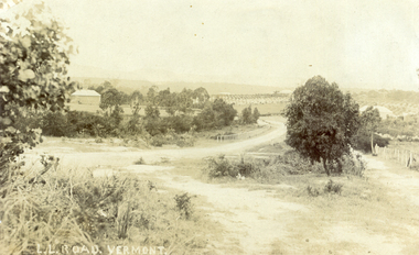
Photograph, L L Road Vermont, late 1800
Dr L L Smith was a pioneer of the Vermont District. He owned 250 acres in the area bounded by Boronia, Canterbury and Heatherdale Roads and the creek. The property was known as L L Vale after which the road was named. Name was changed to Boronia Road in later years. He was a Doctor with rooms in the City, was a member of Parliament.Sepia Postcard of L L Road, Vermont (now Boronia Road) taken in the early 1900s (card is postmarked 27 Aug 1909). Shows the road going down it is presumed to the creek. It is possible that the house is that of Dr.L.L.Smith. See History.|Orchard in background is the Finger orchard. (from Mr. Shambrook - Tim's father)|Information on the back of the Postcard reveal it was sent to Miss Roberts of 61 Hoddle Street Richmond Victoria by Muriel at 37 Victoria Road Northcote and was posted at the Fairfield Post Office Victoria on 27 August 1909. Text is 'Dear Ethel Just a Post Card to let you know I will be out to see you on Monday if convenient. I came down with Mr Hutchinson and he asked me what were we laughing out on the Sunday when he came up. Muriel|See the following references -ND199, 313, 539. 1242, 2013, 3680 & 4295.l l road vermont, boronia road vermont, smith . l l dr -
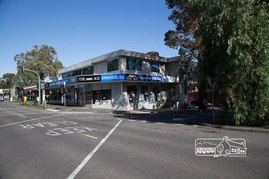
 Eltham District Historical Society Inc
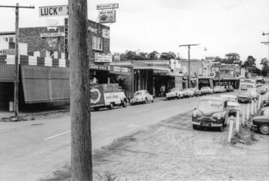
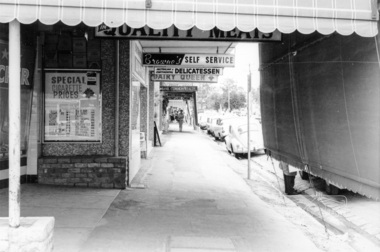
Photograph, Shopping centre, Main Road, Eltham, February 1968, Feb 1968
East side Main Road shops from Luck Street to Dudley Street. Includes Browne's Self Service, Milk Bar, Delicatessen, Chemist, Mac's Meats, Thompson's Pharmacy, N.H. Baxter Estate Agent.In February 1968 an unknown person took a series of photos from the Eltham Hotel at Pitt Street heading north along Main Road through the shopping centre to just north of Elsa Court covering the length of the section of Main Road which was duplicated shortly thereafter. Shows the condition and environment of the streesscape of Main Road, Eltham immediately prior to the duplication between Pitt Street and Elsa Court through the shopping centre. Also shows a number of shops and businesses that operated at that time.Black and white photographduplication, eltham, main road, browne's self service, dudley street, milk bar, delicatessen, chemist, mac's meats, thompson's pharmacy, n.h. baxter estate agent -
 Eltham District Historical Society Inc
Photograph, Russell Yeoman, Construction of fire access on Gumtree Road, Research, by Army Reserve Engineers under command of Captain Bill Oakley, c.1966, 1966c
Bill Oakley was an engineer at the Shire of Eltham. Viewed from west looking east. Road had more zigs and zags in those days on the west side. Russell Yeoman's FC Holden visible at bottom of hill. Digital file only; created from original colour positive slide transparencyresearch (vic.), russell yeoman collection, gumtree road, army reserve engineers, captain bill oakley, fc holden sedan, fire access, streets -
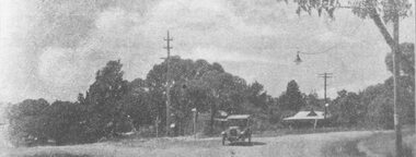
 Ringwood and District Historical Society
Photograph, Intersection of Tortice Dr. Old Warrandyte Road and Warrandyte Road 1981
Written on back of photograph, "19/6/81. Intersection of Tortice Dr. Old Warrandyte Road and Warrandyte Road (on right)." -
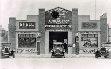 Surrey Hills Historical Society Collection
The Principal Garage at 260 Canterbury Road, Surrey Hills, After 1927
David Staig Jnr established this business in 1927 on the corner of Canterbury Road and Revers Street. He lived at 355 Canterbury Road, one of a series of shops (with living accommodation) owned and built in c1885 by Thomas C Hyde. G Staig (farmer) was the first in the family to occupy this, followed by James Staig (carpenter), then David Staig Snr (blacksmith) and David Staig Jnr. Bill Steiner was the chief mechanic at The Principal Garage; his apprentice Frank Senior eventually bought the business from David Staig and it became Senior's Garage. In 2020 there is a Shell service station and a Coles Express on the site. The Staig family were long-time residents of the area and this photo documents part of their business history. Dave Staig, who established this business, was an early aviator who designed and built his own plane.Black and white photo of a classic 1920's era garage build in brick and render and with 2 petrol bowsers on the curbside, either side of the central garage entrance. Advertising on the facade indicates Shell and Plume motor oils. There are 3 cars positioned in such a way that suggests this may have been a publicity photo. Advertising on the facade indicates that cars could be garaged at the facility and that the proprietor was D. Staig. It also indicates that the business was an agent for The Whippet car, the Willys-Knight car and the Overland car.principal garage, senior's garage, senior's motors pty ltd, garages, redvers street, canterbury road, david staig jnr, bill steiner, frank senior -
 Eltham District Historical Society Inc
Photograph, Shopping centre, Main Road, Eltham, February 1968, Feb 1968
Main Road shops from midway between Luck and Pryor Streets, looking south along the east side. Includes Browne's Self Service, Delicatessen, Dairy Queen, Commonwealth Bank, Mac's Meats and Thompson's Chemist.In February 1968 an unknown person took a series of photos from the Eltham Hotel at Pitt Street heading north along Main Road through the shopping centre to just north of Elsa Court covering the length of the section of Main Road which was duplicated shortly thereafter. Shows the condition and environment of the streesscape of Main Road, Eltham immediately prior to the duplication between Pitt Street and Elsa Court through the shopping centre. Also shows a number of shops and businesses that operated at that time.Black and white photographduplication, eltham, main road, shopping centre, thompson's pharmacy, mac's meats, delicatessen, dairy queen, commonwealth bank, browne's self service -
 Eltham District Historical Society Inc
Photograph, Frank Stokes with daughters Dorothy (left) and Beryl (right) at Stokes Orchard, Nyora Road, Eltham, 1944, 1944
Frank Stokes first traveled to the district by train in 1944 to find land with the intention to establish an orchard. By chance he met Arthur Bird of Bird Orchard (bounded by Pitt Street, Eucalyptus Road and Wattle Grove) and they got talking over their common interest. Arthur put Frank up for the night and pointed out the land, part of Crown Allotment 15, Section 5, Parish of Nillumbik (CA15) somewhat diagonally opposite Bird Orchard. Frank bought the land and for the next two years would travel by train from Melbourne to Eltham every weekend establishing Stokes Orchard and building a home for his family, which they eventually moved into in 1946. In the mid 1970s the Shire of Eltham divided the orchard up into numerous rate-able parcel lots, which became affordable for Frank. As a consequence Stokes Orchard was turned into a housing development by Macquarie Builders and marketed as the Stokes Orchard Estate in two stages; Stage 1 encompassing Scarlet Ash Court, Ironbark Close and Peppermint Grove bounded by Nyora and Eucalyptus roads c.1976 and Stage 2 encompassing Stokes Place, Orchard Way, The Crest and The Lookout bound by Nyora and Diosma roads c.1979. The development of Orchard Way, The Crest and The Lookout did not proceed as planned due to the lack of the sewer along Diosma Road and so many of the proposed lots were incorporated into five-acre parcels instead.Representative of the orchard growing areas of ElthamDigital file only - Digitised by EDHS from a scrapbook (containing commercially printed photos of digital scans) on loan from Beryl Bradbury (nee Stokes), daughter of Frank Stokes.1944, beryl bradbury (nee stokes), beryl bradbury (nee stokes) collection, dorothy stokes, eltham, frank stokes, nyora road, stokes orchard -
 Warrnambool and District Historical Society Inc.
Functional object - car lantern, Joseph Lucas Ltd. Birmingham, England, Lucas King of the Road Lantern, c.1930
This lantern or lamp was used for lighting an automobile or motor cycle in the 1920s or 1930s. It could also have been used in a household or carried by a person. It was made by the English firm of Joseph Lucas Ltd., a business founded in 1860 which originally made scoops, buckets and plant holders. In 1875 it began the production of lamps and in the early 20th century made automotive components. Today after having merged with a North American company it makes components for the automotive and aerospace industries. The term 'King of the Road' was reserved for products that were regarded as the most prestigious and the ones commanding the highest price. This lamp was advertised as one that 'will not blow out in the toughest gale'.This item is retained as an interesting example of the lighting used for cars and bicycles early in the 20th century.This is a metal lantern which is much rusted but which may have been chrome or nickel plated. It has a lighting mechanism enclosed in glass, a handle on the top, a winding screw on the side, an oil container and a metal plaque on the base. LUCAS No. 636 KING of the ROAD JOS.LUCAS LTD. B'HAMcar components, automobile lighting, lucas industries, -
 Surrey Hills Historical Society Collection
Photograph, McPhie family at back of Mounted Police Station, 5 Suffolk Road, Surrey Hills
"Sgt. David McPhie and some of his family/at Suffolk Road Mounted Police Station./Stables are shown in background./Courtesy - Mrs. P. Scales (nee McPhie)." The police established a station at 5 Suffolk Road in 1889. The first policeman was Constable Patrick Healey soon after assisted by Sgt Wilson. Constable David McPhie (1887-1963) was married to Jessica Beatrice McErvale (1891-1962) in 1914. They had a son - Angus (1916-1971) and a daughter Jean Cameron (1918-1985); she was born in Surrey Hills. In 1919 electoral rolls David McPhie is listed as a policeman at 5 Suffolk Road. Police gazettes list him as discharged on 2/11/1923. The family continue to live at 5 Suffolk Road and thereafter he is listed as a labourer. Entry in 'Surrey Hills In Celebration of the Centennial 1883-1983' states there was a mounted troopers' station at 5 Suffolk Road from 1889-1914. It was later at 5 Essex Road and then in 1923 moved to 171 Union Road (later the doctor's surgery and residence) and then to 93 Union Road where it stayed until 1947. It is not known how the donor was related to David McPhie.Image of a man, identified as Sgt. David McPhie, with five female members of his family, standing in front of the stables of the Mounted Police Station at 5 Suffolk Road, Surrey Hills.people, families, family groups, police, policemen, surrey hills mounted police station, horses, stables, suffolk road, david mcphie, miss jessie beatrice mcervale, mrs jessie beatrice mcphie -
 Marysville & District Historical Society
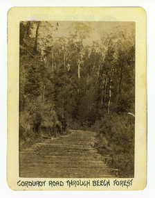
Photograph (Item) - Black and white photograph, Corduroy Road Through Beech Forest, c1900
An early black and white photograph of a corduroy road running through the forest near Marysville in Victoria.An early black and white photograph of a corduroy road running through the forest near Marysville in Victoria. A corduroy road (or log road) is a type of road or timber trackway made by placing logs, perpendicular to the direction of the road over a low or swampy area. The result is an improvement over impassable mud or dirt roads, yet rough in the best of conditions and a hazard to horses due to shifting loose logs.ARMSTRONG COLLECTION 42 STATION STREET/ SANDRINGHAM 3191/ TEL. (03) 9521 5442/ IAN M.L. ARMSTRONG OAMcorduroy road, marysville, victoria, beech forest -
 Marysville & District Historical Society
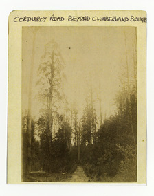
Photograph (Item) - Black and white photograph, Corduroy Road Beyond Cumberland Bridge, c1900
An early black and white photograph of a corduroy road running through the forest near Marysville in Victoria.An early black and white photograph of a corduroy road running through the forest near Marysville in Victoria. A corduroy road (or log road) is a type of road or timber trackway made by placing logs, perpendicular to the direction of the road over a low or swampy area. The result is an improvement over impassable mud or dirt roads, yet rough in the best of conditions and a hazard to horses due to shifting loose logs.ARMSTRONG COLLECTION 42 STATION STREET/ SANDRINGHAM 3191/ TEL. (03) 9521 5442/ IAN M.L. ARMSTRONG OAMcorduroy road, marysville, victoria -
Ringwood and District Historical Society
Pamphlet, Vic Roads, Eastern Freeway: Doncaster Road to Springvale Road extension, and Scoresby Transport Corridor. Pamphlets. 1993-6, 1993-1994 & 1996
Eastern Freeway: Doncaster Road to Springvale Road extension - 2 pamphlets;; Scoresby Transport Corridor: 1 pamphlet. -
 Ringwood and District Historical Society
Photograph, View of Glenvale Road, Ringwood, looking towards Loughnan Road at bridge 1964
See Also #25Written on back of photograph, "1964 - View of Glenvale Road looking towards Loughnan Road at bridge. Original supplied by Garrett Gundry." -
 Ringwood and District Historical Society
Photograph, Whitehorse Road and Mount Dandenong Road, including early electric installation of street lighting. (Undated)
Written on back of photograph, "Whitehorse Road and Mount Dandenong Road". Catalogue card reads, "Early electric installation of street lighting". -
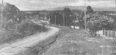 Ringwood and District Historical Society
Photograph, Maroondah Highway West, Ringwood- c1909. View of Whitehorse Road, Ringwood from Heatherdale Road area
Black and white photograph (2 copies, 1 large, 1 small)Written on back of large photograph: "This photo was taken about 1909" and "Picturesque view of Whitehorse Road, Ringwood from Heatherdale Road." -
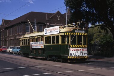 Ballarat Tramway Museum
Slide - 35mm slide/s, Keith Kings, Ballarat No. 36, Domain Road for Tourism Week, 23/09/1971 12:00:00 AM
Yields information about tram 36 when it was used in Melbourne following closure of the Ballarat SEC system for tourist promotion.Colour 35mm slide in a Kodachrome cardboard mount of Ballarat No. 36, after closure of the Ballarat system, in Melbourne, Domain Road for Tourism Week, promoting Ballarat. See Reg item 3501 for photos of its transport to Melbourne and 3432 for a newspaper clipping and 3546 and 3503 for other photos in the same location. Photo shows details of the banners and roof advertisements. Has destination of Sebastopol. Photo from the collection of Lilian Butler.Written around the slide in in k "Ballarat - K. S. Kings No. 90-36, 23/9/1971, and No. 36 running in Melbourne as arranged by the Tourist Development Authority in Domain Road at St Kilda Road.tramways, trams, melbourne, tourism, mmtb, tmsv, domain road, tram 36 -
 Eltham District Historical Society Inc
Photograph, Peter Pidgeon, Newsagency, Main Road, Eltham, 3 May 2017, 3 May 2017
Former site of the Post Office, then Priceline and now the relocated Newsagency; the former site across Main Road being demolished. Post Office has moved up from the original location but still in same building complex. Railway Station and carpark to the right.Born Digitaleltham, railway station, eltham railway station, carparks, newsagency -
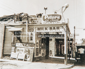 Eltham District Historical Society Inc
Photograph, Fire damaged milk bar, Main Road, Eltham, c.1960, 1960c
Fire damaged milk bar, Main Road, Eltham near Arthur Street. Film poster is advertising The Blob (1958) and "I married a monster from outer space" (1958) which both appear to have been screened in Australia in 1960 and 1961Colour photograph copy of originalshops, main road, eltham, fire, the blob (1958 film), i married a monster from outer space (1958 film) -
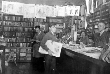 Surrey Hills Historical Society Collection
Photograph, Walker's newsagency, 100 Union Road, Surrey Hills
The photo is of Mr. P.F. Walker's newsagency at 100 Union Road, Surrey Hills. Behind the counter is Miss Bessie Guildford who in the 1940s took over the haberdashery shop of the Misses Orr beside the former A.N.Z. Bank. (In 2018 this site is occupied by Interdrape).A black and white photograph showing the interior of a shop with lots of books on shelves and newspapers on the counter. There are four people in the shop. The young lad in front is holding some newspapers. A man and a lady are standing behind the counter.On the back of the mounted photograph is a piece of paper stuck in the middle at the top with the following information. INSIDE 100 UNION RD./SURREY HILLS/1940-41/Thanked/Aug 89/FROM LEFT/FRANK GUILDFORD/GEORGE WESTLE/BESSIE GUILDFORD/P.F. WALKER/PROPRIETOR/SENT TO NEIGHBOURHOOD/CENTER BY B. GUILDFORD.p f walker (mr), union road, surrey hills, frank guildford (mr), george westle (mr), newsagency, bessie guildford (miss)