Showing 112993 items
matching tracks/roads
-
 Ringwood and District Historical Society
Newspaper, Scrapbook Clipping, Library Collection, Ringwood, Victoria
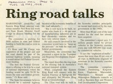
Newspaper Clipping from the ""Mail", 12 May 1998 P5. "Ring road talks"Maroondah councillor and Eastern Ring Road steering committee member Neil Rose last week met State Roads Minister Geoff Craige to discuss funding for the project. The committee is pushing for $800 million in state and federal funding to build the road as soon as possible. -
 Glen Eira Historical Society
Album - Album page, Glen Huntly Road, Circa 1972
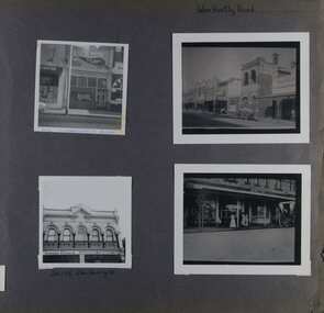
This photograph is part of the Caulfield Historical Album 1972. This album was created in approximately 1972 as part of a project by the Caulfield Historical Society to assist in identifying buildings worthy of preservation. The album is related to a Survey the Caulfield Historical Society developed in collaboration with the National Trust of Australia (Victoria) and Caulfield City Council to identify historic buildings within the City of Caulfield that warranted the protection of a National Trust Classification. Principal photographer thought to be Trevor Hart, member of Caulfield Historical Society. Most photographs were taken between 1966-1972 with a small number of photographs being older and from unknown sources. All photographs are black and white except where stated, with 386 photographs over 198 pages. 376 Glen Huntly Road is a contributory building to HO72 - Elsternwick Estate and Environs, City of Glen Eira.Page 64 of Photograph Album with four photographs of different properties on Glen Huntly Road - 2 in portrait mode and 2 in portrait photographs of photographs.Hand written: Glen Huntly Road [top right] / 376 GLENHUNTLY ROAD [written in blue pen on the bottom edge of the top left photo] / 216-218 Glen Huntly Rd [under bottom left photo] / 64 [bottom right] trevor hart, glen huntly road, elsternwick, shops, streetscapes, vintage cars, carriages and coaches, glenhuntly road -
 Mt Dandenong & District Historical Society Inc.
Photograph, Devine family, Olinda, 1911
Mr Devine, Mrs Devine (nee Stewart) with children Vera and Stewart at their home 'Hillcrest' on Mernda Road (now Coonara road), Olinda 1911. The descriptive text on the reverse of this photograph was hand written by John Lundy-Clarke.Devine, Mrs Devine (nee Stewart) Vera Stewart 1911 on verandah of “Hillcrest” Mernda Road now Coonara Road. Mrs Dodd’s collection. Copied by J.L.C. 1974. vera devine, stewart devine, hillcrest, mernda road, coonara road, olinda, devine -
 Whitehorse Historical Society Inc.
Map, City of Nunawading, 1973
Map showing streets, plot numbers, schools, open space and land usage.Map showing streets, plot numbers, schools, open space and land usage. A project by A Gray, student at Vermont High School. Area covered from Canterbury Road to Burwood Road and Terrara Road to Morack Road. Scale: 800 ft: 1 inchMap showing streets, plot numbers, schools, open space and land usage.vermont south, vermont, vermont high school, parks and reserves -
 The Beechworth Burke Museum
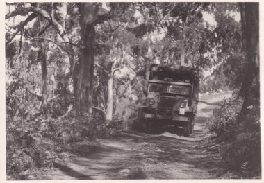
Photograph, 1944
Taken in 1944, the photograph depicts an Australian Army truck driving along an unsealed road from Stanley to the top of Mt. Stanley. A secret experimental micro-wave radio station was established and tested at Mt. Stanley by the Army Signal Detachment Unit during World War II. It was part of an experimental Ultra High Frequency (UHF) link between Melbourne and Sydney. At the time, it was highly classified. It intended to enquire into the hitherto unexplored transmission of micro-waves; that is, a radio signal which could only be transmitted by line of sight, and thus required hill-top to hill-top location.The photograph is historically significant as it pertains to World War II; the largest global conflict in history. This significance is enhanced by Australia's prominent involvement in campaigns across the Pacific, particularly on land in New Guinea and across the Huon Peninsula. It was also the first time that the Australian mainland came under direct attack by the Axis, with Japanese forces targeting north-west Australia and Sydney Harbour. These battles became Australia's largest and most complex offensives during the war. The record is also historically significant as it relates to the Royal Australian Corps of Signals, or "RA Sigs". This significance is strengthened by Australia's unique distinction of having the first established signal unit under the British Empire. This unit provides electronic warfare. They enable commanders to implement highly dynamic battle control against opposing forces by using a number of methods including radio, fibre optic, micro-wave, information systems and satellite links. The record has strong research potential. This is due to the ongoing scholarly and public interest in war, military history, the ANZAC legend, and the continuing existence of the RA Sigs. The historic context of this record can provide insight into Australia's history, military, technological innovation and advancements, as well as national economic, defence and foreign policies after 1945.Black and white rectangular photograph printed on matte photographic paper.Reverse: BMM5095.7 / The track up (?) from / Stanley to the top / 32 /military album, army album, military, war, wwii, world war ii, army signal detachment unit, royal australian corps of signals, beechworth, victoria, stanley, mt stanley, melbourne, sydney -
 Melbourne Tram Museum
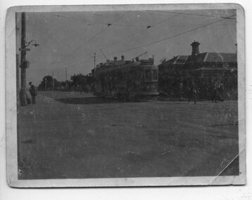
Photograph - HTT Tram 15 at Glenferrie and Riversdale Roads 1916-1920
Photograph shows Hawthorn Tramways Trust bogie Tram 15 at Glenferrie and Riversdale Roads 1916-1920. The tram body was built by Duncan and Fraser of Adelaide and entered service during April 1916. It was renumbered N class 121 by the Melbourne and Metropolitan Tramways Board following the absorption of the Trusts by the MMTB in 1920. The tram is eastbound in Riversdale Road. The tracks of the Prahran and Malvern Tramway Trust can be seen in front of the tram. The conductor has alighted from the tram and walked forward to check for trams on Glenferrie Road. A Fire Brigade street fire alarm can be seen on the corner. The existing connecting curves at the corner were installed in 1925. The tramcar had a number of significant accidents and was disposed of in March 1938. Understood from the donor, that the house on the corner was known as "Pax" and demolished when commercial development of the corner occurred. The donor's family operated the Purvis Real Estate on the southeast corner from the building now known as Stotts Corner. A Golden Fleece service station once operated from the SW corner, now (2022) an Oportunity shop.Yields information about the intersection of Riversdale and Glenferrie Roads Hawthorn, the trams that operated between 1916 and 1920 and tramway practices in having the conductor checking for trams on the adjacent road.Sepia toned or faded print of Hawthorn Tramways Trust tram No. 15 at the corner of Riversdale Road and Glenferrie Road, Hawthorn - first image is a greyscale scan of original image.trams, tramways, hawthorn, riversdale road, glenferrie road, hawthorn tramways trust, tram 15, htt, stotts corner, purvis real estate -
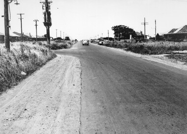 City of Kingston
Photograph - Black and white, c. 1950
A car travelling along South Road Moorabbin, with the Tucker Road intersection on the left hand side. Houses are on either side of the road which also has wide shoulders and nature strips.A car travelling along a sealed road with wide shoulders and houses on either side of the road.Handwritten in red ink on reverse: 72% Handwritten in blue ink on reverse: 2192 [circle around all text, including red ink]transport, moorabbin, cars, houses -
 Melbourne Tram Museum
Photograph - Set of 5 Black & White Photograph/s, Sutcliffe Pty Ltd, c1924
Set of five Photographs, Black and White, of St Kilda Road, with works about to commence to convert the cable tram to electric trams. .1 - Overhead pole holes being dug in the one of the central plantations - pole and a Furphy water cart alongside. A cable tram is passing at speed. Note the scale of the houses opposite and the number of side walk superintendents! .2 - View of St Kilda Road with a few motor cars and one cable tram. Looking south on the Sth Melb. side. .3 - ditto, view of cable tram track, poles laid out on the central plantation, note the street lights. About seven cable trams in the view. Look south towards St Kilda Junction. The Junction hotel is in the view. .4 - similar photo, but further north. Cable trailer 74 in the view. .5 - View of St Kilda Road, vehicle road with a number of vehicles in the view. Looking south on the east side of the roadway. Photos Print and photograph by Sutcliffe of Cromwell buildings 366a Bourke St. Melbourne.In ink and pencil on the rear: .1 - "M&MTB H-60, Kew Depot `1920's (E45 in shed)" and the photographers stamp. .2 - "MMTB St Kilda Road about 1924" and in pencil "Tramway poles erected, pole not removed? Sth Melb side, looking south along motor track" .3 - As above - and in pencil - Tramway poles not erected - ????" .4 - As above with notes in pencil. .5 - As above with notes in pencil. About 1924 KSK print number SA932 to SA936.trams, tramways, st kilda rd, cable trams, conversion, trackwork, overhead, construction, tram 74 -
 St Kilda Historical Society
Photograph, 11 Eildon Road, St Kilda, 1990-2000?
oringinal colour photograph, TV aerial, cars parked in roadcolour photograph, unmounted good condition11 Eildon Road -
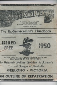 Lara RSL Sub Branch
Handbook, W.A.Cooney, The Road Back, 1947/1950
The handbook was distributed to all ex-servicemen on return from WW2 in the Geelong area and was a guide to civil life.This booklet for returned service personnel from World War 2 living in the Geelong Region is og local district significance as a part of the history of Geelong.The Road Back -two of The Ex-Serviceman's Handbooks,1947/ 1950 Geelong Issued Free.One is Light green in colour with black writingThe Road Back The Ex-Serviceman's Handbook Geelong.the road back, the ex-serviceman's handbook, world war 2, ww2, australian aif, australian serviceman, australian servicewoman, rss&aila, army, navy, air force, returned sailor's, soldier's and airmen's imperial league of australia, rsl -
 Kew Historical Society Inc
Photograph - Riversdale Road, Surrey Hills, E.J. Dower, c.1915
Contextual or historic information One of a series of photographs, taken by Edgar James Dower in the second decade of the twentieth century. Born and raised in Olinda, his family later moved to Surrey Hills. He worked as an adult as a clerk in the city office of the Metropolitan Gas Company, and in his role as a 'collector', he was able to photograph scenes including the construction of tramlines and associated buildings in Kew, Hawthorn, Camberwell and Surrey Hills. Later he established a real estate agency with his brother - the E.J. Dower Real Estate Agency, Dandenong Office.The image is an historically significant record of the development of transport infrastructure which was used to connect Victorians in the first two decades of the twentieth century. This development resulted from increases in population and the consequent extension of Melbourne's suburbs. The photographs, both individually and collectively, richly detail the labour of workers and the tools and machinery used to create and extend Melbourne's tram network in the years preceding and during World War 1.Digital copy of an original oval mounted photograph depicting Riversdale Road, Surrey Hills, before the construction of the proposed electric tramline.Annotated verso: "Riversdale Road Surrey Hills / Preparing for electric tram line / Note Essex Road on right with picket fencing."theme --- travelling by tram, theme -- connecting victorians by transport and communications, riversdale road -- surrey hills, tramlines -- surrey hills -
 Ballarat Tramway Museum
Photograph - Black & White Photograph/s, John Buckland, 23/12/1946 12:00:00 AM
Black and white photograph of Bendigo track cleaner/sprinkler and ESCo No. 9 at the Pall Mall tram stop just to the south of the Fountain at Charing Cross. ESCo 9 has been modified (See Kings Bendigo Tramways p54). Sprinkler car has trolley pole facing Golden Square, as has No. 9. Pole by the trams have signs "ALL CARS STOP HERE" and a "NO ROAD" sign. Photo taken 23/12/1946. 676.1 - Black and White print contained within the Wal Jack Bendigo and Geelong Album, see Reg Item 5003 for more details. Added 2/7/2013. See The Bendigo Tramways, K.S.Kings On rear typed is "SECV Bendigo Tramways Car 9 and Track Grinder at Charing Cross 23/12/1946" and stamped in but rh corner "Photograph by John Buckland" trams, tramways, bendigo, esco, work trams, tram sprinkler, scrubber, tram 9 -
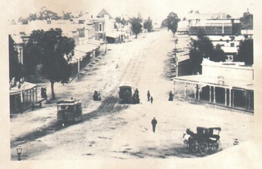
 Camberwell Historical Society
Photograph, Camberwell, Victoria, looking south down Burke Road in Camberwell, c. 1950
Print of photograph looking south down Burke Road. Inscription 'Camberwell, Victoria, looking north down Burke Road in Camberwell c. 1950' which is actually incorrect because it is looking south. Camberwell, Victoria, looking north down Burke Road in Camberwell c. 1950camberwell -
 Kew Historical Society Inc
Photograph, J F C Farquhar, Studley Park Road, 1891
At the beginning of the 1890s, the Kew businessman and Town Councillor, Henry Kellett, commissioned J.F.C. Farquhar to photograph scenes of Kew. These scenes included panoramas as well as pastoral scenes. The resulting set of twelve photographs was assembled in an album, Kew Where We Live, from which customers could select images for purchase.The preamble to the album describes that the photographs used the ‘argentic bromide’ process, now more commonly known as the gelatine silver process. This form of dry plate photography allowed for the negatives to be kept for weeks before processing, hence its value in landscape photography. The resulting images were considered to be finely grained and everlasting. Evidence of the success of Henry Kellett’s venture can be seen today, in that some of the photographs are held in national collections.It is believed that the Kew Historical Society’s copy of the Kellett album is unique and that the photographs in the book were the first copies taken from the original plates. It is the first and most important series of images produced about Kew. The individual images have proved essential in identifying buildings and places of heritage value in the district.In this view of Studley Park Road, looking northeast to the Junction, the photographer invites the viewer to participate in a point-of-view that emphasises the elevated, tranquil vantage point of the hill in contrast to the bustling commercial area in the distance. The view emphasises the exclusiveness of Studley Park, with its high fences behind which a number of significant Kew mansions were concealed. Contemporary advertisements for the sale of mansions in Studley Park Road often included fulsome descriptions of their elaborate formal gardens, as well as paddocks for grazing, stabling and dairies. None can be seen here. The use of high, protective wooden pickets to surround the newly planted avenue of elms on the south side of the road appears to be typical of the period. Similar examples can be seen in early photographs of Wellington and Princess Streets.The horse and carriage, selected as a central focus of the view, reinforces the residential, exclusive nature of this part of Kew in the early 1890s. Studley Park Roadkew illustrated, kew where we live, photographic books, henry kellett -
 Glen Eira Historical Society
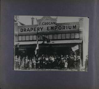
Album - Album page, Glen Huntly Road, Circa 1972
This photograph is part of the Caulfield Historical Album 1972, showing a crowd gathered in front of T Grogan's Drapery Emporium, entitled "6: Opening Day Glen Huntly Road Electric Trams 13.11.12". This album was created in approximately 1972 as part of a project by the Caulfield Historical Society to assist in identifying buildings worthy of preservation. The album is related to a Survey the Caulfield Historical Society developed in collaboration with the National Trust of Australia (Victoria) and Caulfield City Council to identify historic buildings within the City of Caulfield that warranted the protection of a National Trust Classification. Principal photographer thought to be Trevor Hart, member of Caulfield Historical Society. Most photographs were taken between 1966-1972 with a small number of photographs being older and from unknown sources. All photographs are black and white except where stated, with 386 photographs over 198 pages.Page 71 of Photograph Album with one photograph (in portrait) from Glen Huntly Road taken circa 1912. Hand written: 71 [bottom left] // title on photograph " 6: OPENING DAY GLEN HUNTLY ROAD ELECTRIC TRAMS 13.11.12"trevor hart, glen huntly road, elsternwick, shops, electric trams, crowds, buildings, flags, victorian, opening day, celebrations, glenhuntly road, t grogan's drapery emporium, clothing shops, openings (events), t grogan -
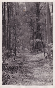 The Beechworth Burke Museum
Photograph, Christmas 1941
Taken on Christmas of 1941, shown is a track to Lake Kerferd with forest on both sides. The construction on Lake Kerferd began in 1862 however it wasn't completed until 1874 due to engineering and funding issues. The lake was named after George Briscoe Kerferd (1831–1889) who was responsible for Beechworth's water scheme. George Briscoe Kerferd was born on 21 January 1831 in Liverpool, England and arrived in Melbourne April 1853. He spent his first years in Australia in Bendigo before settling down in Beechworth as a wine and spirits merchant. He married Ann Martindale on 17th December 1853 at St James Cathedral, Melbourne and between them they had three sons and five daughters. Kerferd began his political and legal career in Beechworth when he was first elected to the Municipal Council in May 1857. Later he would be elected to the Legislative Assembly for the Ovens District in November 1864, and continued to represent the area until February 1886.This photograph is historically significant as it provides insight into surrounding areas of the water reserves of Victoria. It is also linked to political identity of George Briscoe Kerferd and the Beechworth Municipal Council.Black and white rectangular photograph printed on matte photographic paper.Obverse: Reverse: 8163/ Back track to Lake Kerford/ Beechworth/ Xmas 1941lake kerferd, beechworth, water scheme, water reserve, forest track, forest pathway, reservoir, legislative assembly, hon. george briscoe kerferd, catchments, beechworth water reserve, beechworth catchments, municipal council, st. james cathedral, lakes, reserve, water supply, political projects -
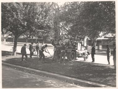
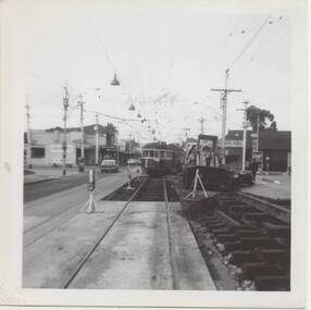
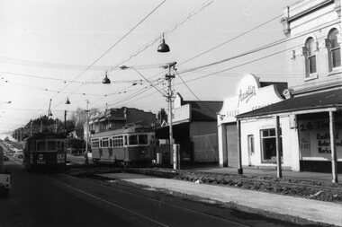 Ballarat Tramway Museum
Photograph - Black & White Photograph/s, early Oct. 1965
Set of two Black and white photographs on Kodak paper of the track reconstruction in Hawthorn Road Caulfield, Inkerman St. area. Photo taken during early Oct. 1965. East track was complete by 9/10/1965 (Electric Traction 11/1965). 1421.1 - Hawthorn Road, looking north from Inkerman St. SW6 953 outbound. 1421.2 - Hawthorn Road between Inkerman St and Balaclava Road - SW6 853 outbound, passing an inbound tram. Note steel-wood cross over bridge between the two tracks. See P.Winspur note - and Electric Traction Nov. 1965 and data sheet for Reg. Item 1418trams, tramways, hawthorn road, caulfield, trackwork, mmtb, tram 953 -
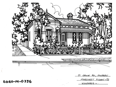 Hawthorn Historical Society
Drawing - Property Illustration, 51 Grove Road, Hawthorn
'After training as a Cartographic Draftsman within the mining industry, I worked as a property illustrator for real estate firms in the eastern suburbs of Melbourne for 23 years from 1983. I initially photographed houses with a Polaroid camera and made a 'thumbnail' sketch while there. The photos were used to scale off a sketch in pencil and then that sketch was overlaid with drafting film and the 'pen and ink' completed. The pens I used were the Rotring ‘Rapidigraph’ drafting pens. The ink was also made by Rotring (German).The film was ‘Rapidraw’, polyester drafting film, double matte. It takes a very fine line and doesn’t bleed. As well as house sketches, there were often floor plans and site plans ordered. Aerial sketches were ordered when the property needed an overall view.' (Margaret Picken, 2020)This property illustration is one of a series created by Margaret Picken for a range of real estate agents in Melbourne between c. 1983 and c. 2006. Each work is signed and dated by the artist.Gift of Margaret Picken, 2020Pen and ink property illustration on drafting film of 51 Grove Road, Hawthorn by Margaret Picken.51 Grove Road, Hawthorn, Margaret Picken '93. Woodards. artist - margaret picken 1950- -
 Phillip Island and District Historical Society Inc.
Photograph, Early 1900's
One of 16 photographs and postcards donated by Mary KarneyBlack & White postcard of the Beach Road, Cowes. Where the "Coninental" is now."The Rose Series P 674" "the Beach Road, Cowes, Phillip Island, Victoria."beach road cowes, cowes, phillip island, mary karney -
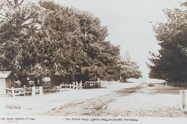
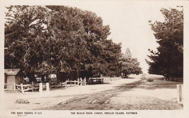 Phillip Island and District Historical Society Inc.
Photograph
Part of collection donated to the Museum by Mr. Bernard Grayden. 1975Postcard showing unmade Beach Road, Cowes, with fences and Pine trees.The Beach Road, Cowes, Phillip Island, Victoria. The Rose Series P 674local history, documents, postcards, beach road, cowes, phillip island, sepia postcard, beach road cowes, bernard grayden -
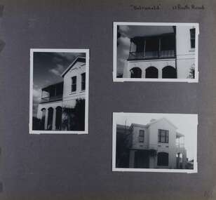 Glen Eira Historical Society
Album - Album page, Balranald, Poath Road, Circa 1972
This photograph is part of the Caulfield Historical Album 1972. This album was created in approximately 1972 as part of a project by the Caulfield Historical Society to assist in identifying buildings worthy of preservation. The album is related to a Survey the Caulfield Historical Society developed in collaboration with the National Trust of Australia (Victoria) and Caulfield City Council to identify historic buildings within the City of Caulfield that warranted the protection of a National Trust Classification. Principal photographer thought to be Trevor Hart, member of Caulfield Historical Society. Most photographs were taken between 1966-1972 with a small number of photographs being older and from unknown sources. All photographs are black and white except where stated, with 386 photographs over 198 pages. Originally named Crofthead or The Croft Head, later changed to Balranald according to Melbourne Mansions database.From Victorian Heritage Database citation for HO136 13 Poath Street MURRUMBEENA https://vhd.heritagecouncil.vic.gov.au/places/35389 as at 30/10/2020 "Croft Head" is situated at no. 13 Poath Road, Murrumbeena, and was built in 1887 for the accountant Edward Tweddell. It is historically and aesthetically significant. It is historically significant (Criterion A) as a substantial and now rare (Criterion B) surviving late Victorian villa residence east of Booran Road within the Municipality and demonstrating the attraction of Melbourne's rural fringe as a residential location rendered accessible by the opening of the railway between South Yarra and Oakleigh in 1879. It is aesthetically significant (Criterion E) as one of the Municipality's finest late Victorian polychrome brick villas, comparing with ''Fresch'' and ''Monkleigh'' both erected in 1899 at nos. 11 and 12 Gladstone Parade, Elsternwick respectively, ''Hartington'' (1888) at 15 Gladstone Parade and ''Hengar'' (1889) at no. 356 Glen Eira Road, Caulfield South. Elements of stylistic significance include the ornamentation of the brickwork in polychrome work with tiled panels, the effect of the banding being especially striking and representative of the period.Page 166 of Photograph Album with three photographs of Balranald on Poath Road.Handwritten: "Balranald" 13 Poath Road [top right] / 166 [bottom right]trevor hart, decorative brackets, chimneys, verandah, porch, poath road, arches, cast iron columns, return verandah, croft head, balranald, victorian villa, restoration, 1880's, edward tweddell, murrumbeena, hughesdale, cast iron frieze, victorian style, cast iron work, rendered brick, house names, polychrome brick, poath street, crofthead, the croft head -
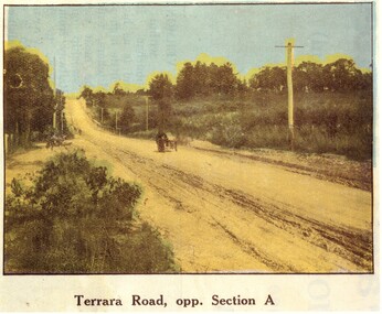 Whitehorse Historical Society Inc.
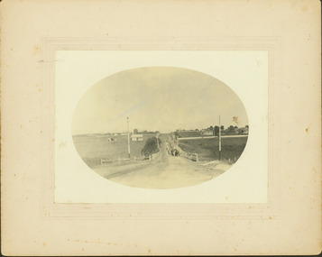
Photograph, Terrara Road Vermont
Terrara Road Vermont . Countryside uncultivated and road unmadeHand coloured black and white photograph of Terrara Road Vermont showing dirt road and one buggy. terrera road, vermont -
 Bendigo Historical Society Inc.
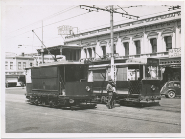
Photograph - HARRY BIGGS COLLECTION: EAGLEHAWK ROAD
Photograph. Harry Biggs Collection. 7 black & white photos of Eaglehawk Road from Eaglehawk Town Hall towards Bendigo. 2 tram cars are on the tracks & a horse & carriage are on the right of the photo. There are people at one of the trams. Shops are on other side of the tracks.photograph, streetscape, eaglehawk, harry biggs collection, eaglehawk road -
 Melbourne Tram Museum
Photograph - Black & White Photograph/s, Mark Plummer, late 1960's
Black and white photo of W2 562 or 502, leaving a "shoofly" temporary track deviation during road / track reconstruction. Location not known at this time. Photo by Mark Plummer late 1960's. Note the kerosene warning lamps, could be route 69.Has the "Mark Plummer" stamp on the rear.trams, tramways, mmtb, track repairs, trackwork, tram 562? -
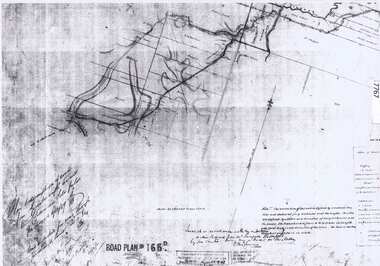 Greensborough Historical Society
Document - Road Plan, Road acquisition, St Helena Road, 1859, 1889
Road plan showing land acquisition for the road to Diamond Creek (NOT Diamond Creek Road), also known as Eltham Road and now known as St Helena Road.Shows the land through which St Helena Road runs, with original owners marked on plan.1 page. Copy of road planroad plans, st helena road greensborough, diamond creek -
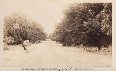 Phillip Island and District Historical Society Inc.
Photograph
Part of collection donated to the Museum by Mr. Bernard Grayden. 1975Postcard showing view along Beach Road, Cowes."Along Beach Road, Cowes, Phillip Island, Victoria". Real Photo Series M 1258local history, documents, postcards, beach road, cowes, phillip island, sepia postcard., beach road cowes, bernard grayden -
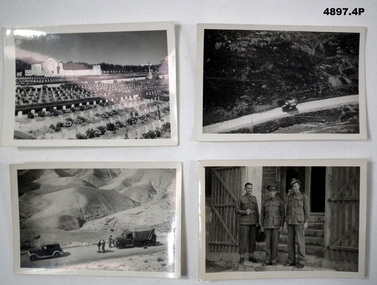 Bendigo Military Museum
Photograph - PHOTOGRAPHS, 1939-45
Albert Edward Corrie VX47191, 6th Div Postal Unit.1. Black & White Photograph - Cemetery, Memorial, Headstones. 2. Black & White Photograph - Truck on Road 3. Black & White Photograph - Sand Hils, vehicles and 3 men on road, 4. Black & White Photograph - 3 uniformed soldiers.1. War Cemetery Jerusalem. 2. On the road to the Dead Sea. 3. Some of the hills on the road to the Dead Sea. 4. Hec McKinnon, CAPRT Cohen, Kirk White.photographs, ww2, postal unit -
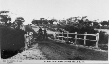 Phillip Island and District Historical Society Inc.
Photographs, The Road to The Nobbies, Phillip Island
Part of a collection of 'Rose & Valentine' series of Post Cards. Copied by John Jansson 1984Black & White Postcard. View of the Nobbies Road with horse and trap about to cross bridge.The Rose Series No. 3427. The Road to The Nobbies, Cowes, Phillip Island, Victorialocal history, photography, photographs, postcards, black & white postcard copy, the nobbies, nobbies road, phillip island -
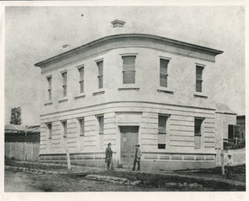 Kilmore Historical Society
Photograph, 1 Powlett Street, 1867
Original image was published in the book "Kilmore on Sydney Road"8x10 black and white photograph of 1 Powlett street, former colonial bank of Australasia. corner of Powlett Street and Lancefield Road Copy printed on standard photographic paper Two story light coloured rendered building with blue stone street curbing. Two figures standing outside the door with a third to the right. Picket fence to left and right of building. Printed on the back REPRODUCTIONS RIGHTS RESERVED Copied by State Library of Victoria KOSR - 5 ("Kilmore on the Sydney Road", Chapter 1, Pg.5)powlett street, lancefield road, colonial bank of australasia, 1867, kilmore, bank, the court house hotel, hotel, kilmore on the sydney road -
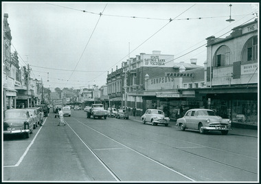
 Camberwell Historical Society
Photograph, Camberwell, Victoria, view of Toorak Road and stores, c. 1950
Print of photograph of Middle Camberwell with inscription 'Camberwell, Victoria, view of Toorak road and stores, c. 1950' Camberwell, Victoria, view of Toorak road and stores, c. 1950camberwell