Showing 92570 items matching "victoria."
-
 Lakes Entrance Historical Society
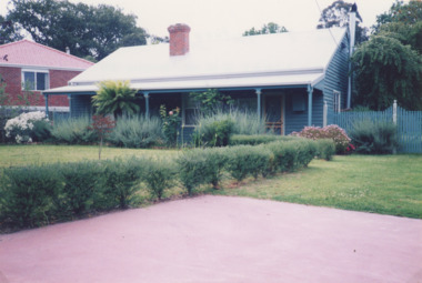
Photograph, M Holding, McMillans Metung Victoria, 1/11/1999 12:00:00 AM
Colour photograph of holiday cottage at McMillans Metung Victoria. tourism, accommodation, metung -
 Lakes Entrance Historical Society
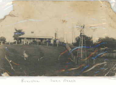
Postcard - Fish Family, Riverslea, the old home of Alf Fish, Swan Reach Victoria
the old home of Alf Fish and family with windmill in foregroundBlack and white photograph Riverslea, at Swan Reach VictoriaThe Fish home at Swan Reach written by Mrs Vic Fish of Bairnsdalegenealogy, houses, fish family -
 Clunes Museum
Ephemera - CALENDAR, 1970
State Savings Bank of Victoria, is not longer operatingState Savings Bank of Victoria 1971 single page calendar, picture depicting Fraser Street, Clunes, picture depicting Fraser Street, Clunes done by Kenneth Jack. Nilstate savings bank of victoria, calendar, 1971 -
 Tatura Irrigation & Wartime Camps Museum
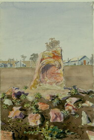
Painting - Painting - Watercolour, Leonhard Adam, 1941 Arandora Star Monument, Tatura, Victoria, 1941
Leonhard Adam was a Dunera internee in Camp 2 Tatura.RomanticismWatercolour painting of memorial carved in stone at Tatura internment Camp 3. Barracks in the backgroundLeonhard Adam. 1941, 'Arandora Star' Monument, Tatura, Victoriatatura, dunera, internee camps, illustrations, watercolour, arandora star -
 Stawell Historical Society Inc
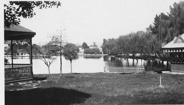
Photograph - Valentine Series No. 1082 Lake Victoria Park, Stawell, Victoria Park Stawell with two Rotundas one cast iron and one wood (Now Cato Park)
Valentine Series Postcard. Victoria Park later Cato Park at Head of the St George Mine Dam originally established with donations from Mr E Simmons and voluntary efforts. Shows two rotundas.B/W Photo. Valentine Series No. 1082 Lake Victoria Park, Stawell. Taken between the two rotundas showing lake, pier and older willows. Both now renamed Cato lake and Cato park.Valentines Real Photo Series Logo. Published by the Valentine Publishing Co. Pty. Ltd. Queen St. Melb.stawell -
Glenelg Shire Council Cultural Collection
Memorabilia - Label - Henty Cordials Mandarin Flavour, Henty Cordials and Aerated Waters,Portland, Victoria, n.d
(Previous collection, Exhibitions, Prizes, etc.) Displayed at History House. Used by Henty cordial company in Portland (?)Label - Mandarin Flavour Henty Cordials and Aerated Waters Portland, Victoria.Front: (text on label includes brand name, flavour of drink, etc...) -
 Kew Historical Society Inc
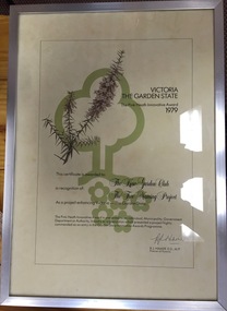
Award, State of Victoria, The Pink Heath Innovative Award: Kew Garden Club, 1979
The Pink Heath is an award by the Government of Victoria. It was awarded to Kew Garden Club in 1979 in recognition of its tree naming project.Victoria: The Garden State - The Pink Heath Innovative Award 1979. Certificate awarded to the Kew Garden Club in recognition of The Tree Naming project. Signed Rupert J. Hamerkew garden club, victoria: the garden state, pink heath award -
 Flagstaff Hill Maritime Museum and Village
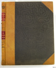
Book, Acts of Parliament of Victoria 34
Acts of Parliament of Victoria 34 Victoria, 1870 Publisher: Government Printer Melbourne Date: 1871warrnambool, shipwrecked-coast, flagstaff-hill, flagstaff-hill-maritime-museum, maritime-museum, shipwreck-coast, flagstaff-hill-maritime-village, shipwrecked-artefact, great ocean road, book, warrnambool library, warrnambool mechanics’ institute, mechanics’ institute library, victorian library board, warrnambool books and records, warrnambool children’s library, warrnambool public library, acts of parliament of victoria 34 -
 Flagstaff Hill Maritime Museum and Village
Book, Acts of Parliament of Victoria 35
Acts of Parliament of Victoria 35 Victoria, 1871 Publisher: Government Printer Melbourne Date: 1871warrnambool, shipwrecked-coast, flagstaff-hill, flagstaff-hill-maritime-museum, maritime-museum, shipwreck-coast, flagstaff-hill-maritime-village, shipwrecked-artefact, great ocean road, book, warrnambool library, warrnambool mechanics’ institute, mechanics’ institute library, victorian library board, warrnambool books and records, warrnambool children’s library, warrnambool public library, acts of parliament of victoria 35 -
Whitehorse Historical Society Inc.
Article, Aboriginal tribal boundaries of Victoria, n.d
Map of Victoria showing tribal names and boundaries in Victoria with comment on activities of the Christian Action Committee.Map of Victoria showing tribal names and boundaries in Victoria with comment on activities of the Christian Action Committee.Map of Victoria showing tribal names and boundaries in Victoria with comment on activities of the Christian Action Committee.aborigines, christian action committee -
 Eltham District Historical Society Inc
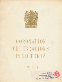
Book, Coronation celebrations in Victoria, 1953, 1953
An official programme of the celebrations held in honour of the coronation of Queen Elizabeth II in Victoria covering Sunday 31st May to Thursday 11th June 1953.1 folded sheet [4] p. ; 22 cm.[typed on Shire of Eltham letterhead pasted inside front cover] May 22nd. 1953. [to] Cr. E.P. Harmer, Bolton Street, Eltham. Dear Sir, Please find enclosed herewith Official Programme for Coronation Celebrations in Victoria, received by me this day. Yours faithfully, [rubber-stamped signature illegible] Shire Secretary.queen elizabeth, coronation, royal visit -
 Surrey Hills Historical Society Collection
Photograph, Streetscape near the corner of Victoria Crescent and Hotham Street, Surrey Hills
Prior to subdivision for housing this area was paddocks used for grazing of cattle and used as part of the course in the early days of the Surrey Hills Golf Club. Reproduced by permission of Mr John Arnold from his book: "The Riversdale Golf Club - a history, 1892-1977." Copyright to book: Riversdale Golf Club. Surrey Hills Golf Club operated from 1892-1908 then moved and became Riversdale Golf Club. The game was played across paddocks from Trafalgar Street, Mont Albert to Whitehorse Road and down Victoria Crescent to where Box Hill TAFE is now located in Elgar Road. There were problems with cows eating the tee flags! The clubhouse still exists as 30 Trafalgar Street.Black and white photo taken from the centre of a bitumen road which is flanked by bluestone guttering. Nature strips, drive cross-overs and house fences are shown. Trees on the RHS nature strip are pollarded to avoid overhead power and telephone lines. There houses in the background."Bottom: The same view today taken from the intersection of Victoria Crescent and Hotham Street, Surrey Hills."surrey hills golf club, hotham street, victoria crescent, riversdale golf club, surrey hills, john arnold -
 Ringwood and District Historical Society
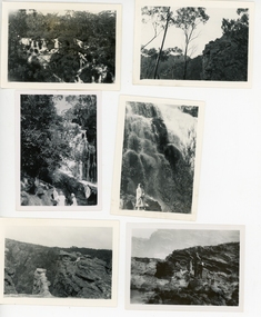
Photograph, 28 photos of Ruby Harker (nee Wilson) and friends and views - Grampians Victoria c 1940s etc; Also Rockhampton Gardens (2 photos)
Ruby Harker (nee Wilson) and friends on holiday in the Grampians and elsewhere, Victoria., and Rockhampton.28 small Black and white photos of scenic spots in the Grampians in Victoria, Coastline, caves and also Rockhampton Gardens. Ruby and friends. Some have written descriptions on the reverse but no dates. (Scanned in groups of 6). See also VC record 28011 which has more holiday photos of the Grampians etc. -
Yarrawonga and Mulwala Pioneer Museum
Map, Map of Victoria, 1868
Original property of Alice Rebecca Puckey [nee Ford] Born England 23/07/1867 Died rosbud Vic 16/03/1951 Grandmother of Merven Elizabeth Clarke 30 Sturt st Mulwala1868 Map of Victoria -
Whitehorse Historical Society Inc.
Pamphlet, Police in Victoria 1836 - 1980, 1980
History of Victoria Police bookHistory of Victoria PoliceHistory of Victoria Police bookvictoria police force, police -
Whitehorse Historical Society Inc.
Book, Pictorial history of Victoria, 1974
A pictorial history of Victoria.A pictorial history of Victoria.A pictorial history of Victoria.schwerkolt cottage, victoria -
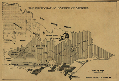 Ballarat Heritage Services
Map, Physiographic Divisions of Victoria, c1940, c1940
Physiographic map of Victoriavictoria, map, physiography -
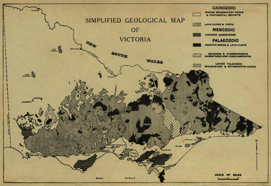 Ballarat Heritage Services
Map, Simplified Geological Map of Victoria, c1940, c1940
Physiographic map of Victoriavictoria, map, geology, geological -
Stawell Historical Society Inc
Map, Geological Survey of Victoria
Geological Survey of Victoriastawell -
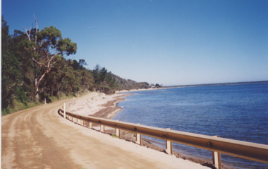 Lakes Entrance Historical Society
Photograph, Lakes Post Newspaper, Lake King, Metung Victoria, 1/02/1999 12:00:00 AM
Colour photograph of road around Lake King Beach looking South, Metung Victoria. Also a colour photograph showing rocky shore of Lake King Beach Metung Victoria boardwalk, people, waterways -
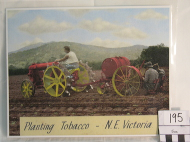 Myrtleford and District Historical Society
Colourized Photograph, "Planting Tobacco N.E. Victoria
The photograph depicts the 2nd important stage in tobacco growing--transplanting seedlings into open paddocks. It depicts early post-war machinery in use at the time until affordable modern tractors were available. The planting machine has probably been adapted from the horse-drawn era pre-World War 2. The scene is one near Myrtleford in the Ovens Valley.The photograph depicts the slow adaptation of modern tobacco farming methods in the immediate post-war period and the type of terain suitable for tobacco growing. The labour intensive nature of tobacco planting is also depicted.A colourized photograph of tobacco planting activity in a paddock near Myrtleford.Inscription: Planting Tobacco N.E. Victoria"tobacco farming tobacco planting machinery -
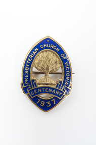 Uniting Church Archives - Synod of Victoria
Lapel Badge, Presbyterian Church of Victoria Centenary 1937
This badge was worn by thousands of people during the year of 1937.5 Oval shaped gold metal and blue enamel badges"Presbyterian Church of Victoria Centenary 1937"presbyterian church of victoria centenary, presbyterian -
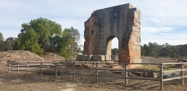 Ballarat Heritage Services
Photograph, Grand Duke Mine, Timor, Victoria, 04/05/2025
Running through this reserve was one of Victoria's richest gold deep leads. From 1869 to 1896 this mine produced 216,000 ounces of gold, valued at over £885,000. The Timor area was mainly mined by the Duke and Timor Gold Mining Company, later known as Duchess of Timor, Duke, and Grand Duke. On 03 May 1869, at a traditional afternoon ceremony, the machinery was started and launched by the old process of 'giving it a name'. A baptismal ceremony was performed, with a Miss Eliza Watson dashing a bottle of champagne over the fly wheel on its first revolution and proclaiming its name to be 'The Galatea'. The mine here was renowned for the massive pumping engine it boasted. Imported from England, the massive Cornish pump was an improvement that was added in 1874. It had a 30 ton iron beam. The mine was the economic centre of this area, employing hundreds of men over its 27 years. At the height of its operation the company's proprietors boasted that nearly all the inhabitants of the nearby towns of Timor and Bowenvale depended on the mine for support. There were some tumultuous times at the mine, with periods of financial strife as well as accidents. When the pumps broke down in 1879 the mine flooded and remained out of action for two years. Mining was a dangerous occupation and a tragic accident in December 1883 claimed the lives of four men. As the ground here was so wet, pumping water out of the mine was crucial to safely reach the gold. It was this pumping engine, reported to be the largest of its kind in Australia, and comparable in size to just two others in the world, that was the key to the success of the Grand Duke mine. Many other smaller nearby mines also had their water pumped out. During the last seven years of the mine's operation it pumped out 2,000 gallons of water every minute, making this the longest and most continuous wet mine in the state. As well as the pump house and engine, there were four main shafts, 12 Cornish flue boilers, eight iron puddling machines and one battery of 20 heads. A massive pumping engine The arch before you is all that remains of the pump house that served to remove water from this mine. When mining started at Timor in the late 1860s the ground here was very wet. If miners were to have any success in reaching the gold they had to remove the water from the ground. To deal with this challenge the company imported a massive Cornish pumping engine from England to pump water out of the mine. It was reputed to be one of the best pumping engines in the world at the time. The engine generated 270 horsepower and its iron beam, weighing 30 tons, was the largest in Victoria. The beam of the large pumping engine see-sawed on this pump house wall to move the plunger or bucket in the pump up and down. The vertical cylinder was 80 inches in diameter with a stroke of 10 feet. The piston itself was eight inches in diameter and 17 feet high and the piston pump had a diameter of 22 inches. For such large engines a massive wall to support the beam was necessary. The piston operated on the downstroke and consequently the cylinder had to be anchored to a considerable foundation to overcome the weight of the pump rods in the shaft. The whole apparatus had to be contained in a tall building because of its vertical configuration. The pumping engine's building has beam walls six feet wide and over 26 feet long which rest on foundations 16 feet deep. The granite used to construct the arch was quarried at Mt Hooghly, some eight or nine kilometres away.Colour photographs of the Grand Duke Mine at Timor near Maryborough, Victoria.grand duke mine, timor, maryborough, mining, duke and timor gold mining company, duchess of timor -
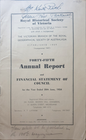 Federation University Historical Collection
Booklet, Royal Historical Society of Victoria 45th Annual Report and Financial Statement of Council, 06/1954
The RHSV was established in 1909.14 page annual report of the Royal historical Society of VictoriaFront cover "Mr Keith Rash Golden Point Ballarat" "Your article will be published in the 100th magazine".royal historical society of victoria, annual report -
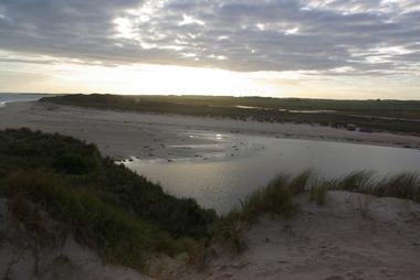 Victorian Interpretive Projects Inc.
Photographs - Colour, Killarney Beach, Victoria, 2014, 13/09/2014
Killarney beach is in close proximity to Port Fairy and Koroit,A number of colour photographs showing scenes of Killarney Beach, Victoria.killarney, beach -
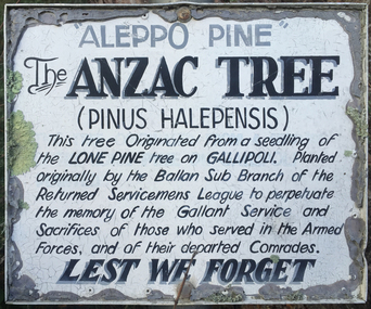 Victorian Interpretive Projects Inc.
Photograph - Colour, Clare Gervasoni, Lone Pine at Ballan, Victoria, 2015
Three photographs relating to a Lone Pine planted at Ballan Victoriaballan, world war, world war one, lone pine, gallipoli, mmm -
 Ballarat Heritage Services
Photograph - Digital photographs, Clare Gervasoni, Emus at Tower Hill near Koroit, Victoria, 29/06/2020
Digital images of emus on Tower Hill near Koroit, Victoriakoroit, moyne shire, volcano, maar, game reserve, tower hill, tower hill, emu, wildlife, native, bird, flightless -
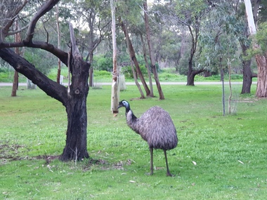
 Ballarat Heritage Services
Photograph - Colour, Clare Gervasoni, Southern Cross, Victoria, 2019, 01/01/2019
A number of photographs of the main road through Southern Cross, Victoria. southern cross -
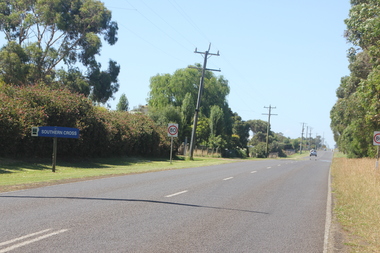
 Ballarat Heritage Services
Image - Black and White, Closing Rabbit Burrows, Victoria, c1950, c1950
A black and white image of a person closing of a rabbit burrow in Victoria . vermin, rabbit, rabbit burrows -
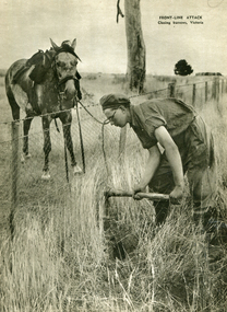
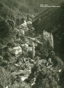 Ballarat Heritage Services
Image - Black and White, Walhalla, Victoria, c1950, c1950
A black and white image of the former mining town in Victoria - Walhalla.walhalla, mining