Showing 1103 items
matching west side
-
 Anglesea and District Historical Society
Pennant, Unknown
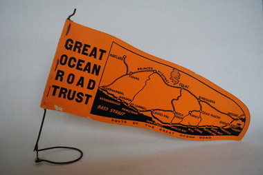
Orange pennant flag listing towns on and near the Great Ocean Road. List of town names on pennant - (west to east) Mortlake, Warrnambool, Nirranda, Terang, Port Campbell, Lavers Hill, Colac, Beech Forest, Apollo Bay, Wye, Birregurra, Forrest, Deans Marsh, Peterborough, Princetown, Lorne, Eastern View, Airy's Inlet, Anglesea, Torquay, Geelong, Barwon Heads.GREAT/ OCEAN/ ROAD/ TRUST. Map of Area/ Route of the Great Ocean. (Orange - on wire stand. Printed on both sides.) great ocean road trust -
 Wangaratta RSL Sub Branch
Postcard, 1917
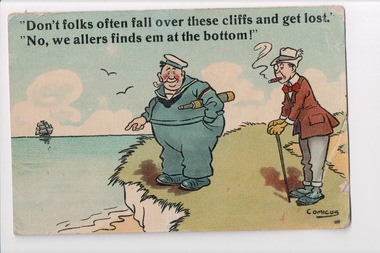
From the album of WWI soldier William West (1268) of the 29 Infantry Battalion, 5th Pioneers Battalion. This collection of postcards, photographs and clippings were sent between William and his family and loved ones during the years he was on active service. See also 207 and 220. Postcard with a colour cartoon of two men standing on the side of cliff next to the ocean. One man is dressed in a sailors uniform. The other is wearing a suit and smoking a cigar. Handwritten message on the back.Front: "Don't folks often fall over the cliffs and get lost." / "No, we allers finds em at the bottom!"album, photo album, newspaper clippings, postcard, wwi, cliff, sea, ocean, sailor, cigar, pipe, cartoon -
 Tatura Irrigation & Wartime Camps Museum
Photograph, Collivers Shop, 2001
Colliver's cafe located north side of Hogan Street just west of railway crossing. Photo 2 c.1970. Photo 3 1984 just prior to demolition. Four photos.Photos 1 & 4 taken in 1950hogan street, colliver, photograph, buildings -
Tatura Irrigation & Wartime Camps Museum
Photograph - copy, House built by John Sebastian Smith
Weatherboard house, shingle roof, former hotel, 6 kms. west of Merrigum on Andrews Road, south side. The house was built by John Sebastian Smith who built the first hotel in Merrigum, and occupied by Thomas Alcorn from 1911 until 1967. Demolished in 1982.Photocopied photo and letter of explanation. -
 Uniting Church Archives - Synod of Victoria
Photograph, Rev. Norman and Mrs. Lowe, Mid-1960s
Norman Lowe's placements: Underbool 1953; Merbein 1955; Wodonga & Bethanga 1960; Immigration chaplain 1961-1962; Carlton & Fitzroy Mission 1963; Church of All Nations 1971; West Heidelberg 1974; Approved appointment Community Health Yallourn 1976. Later also Boronia, Dartmoor-Merino, and the Macedonian Church Preston. Lowe was born in 1924, ordained in 1958, and died on 11 November 2013.(F375-1) Lowes standing side by side; (F375-2) Lowe standing by airport exit gate (location unknown) with a large crowd ready to welcome him; (F375-3) Lowes standing amidst the welcoming crowd; (F375-4) Lowe talking to the welcoming crowd; (F375-5) Lowe standing amidst the welcoming crowd; (F375-6) Lowe being hugged by an unknown man from the welcoming crowd."The names of Norman Lowe and Mrs Lowe"lowe, norman -
 Uniting Church Archives - Synod of Victoria
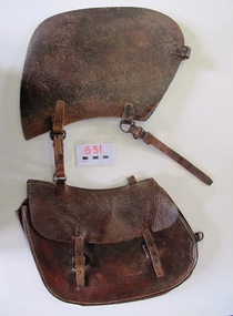
Saddlebag
This small saddle bag was carried on the off-side (right hand side) of the saddle. Nyah West is a town in Victoria, near the Murray River. It is near the Murray Valley Highway, 371 kilometres north-west of Melbourne and 27 kilometres north-west of Swan Hill.Dark brown leather single small saddlebag. The bag is secured with two buckles. -
 Hume City Civic Collection
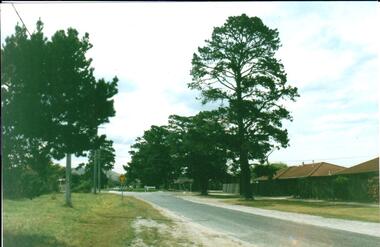
Photograph, Early 1980's
A coloured photograph of Cornish Street, looking west taken from Horne Street, with an avenue of pine trees on either side of the road. There is a roundabout at the first intersection and Mt. Holden can be seen in the distance.cornish street, horne street, mt. holden, george evans collection -
 Hume City Civic Collection
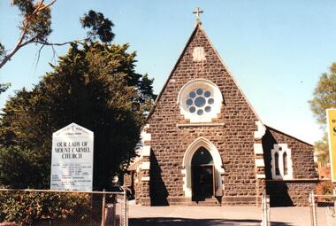
Photograph, early 1990s
Our Lady of Mt. Carmel Church was designed by the architect William Wardell. Prior to the construction of the church, mass was conducted at the Daniel Home 'Narbonne'. The foundation stone was laid on 13/11/1804 by the Catholic Bishop of Melbourne, Rev. Dr. J. Goold and the church opened in 1875 with later additions erected in 1890.A coloured photograph of Our Lady of Mount Carmel Church. It is an image of the front on west end of the church which highlights the rose window above the door and shows the skillion roofed room on the south side of the church. On the LHS of the photograph there is a board giving details of the mass times and clergy.wardell, william, our lady of mount carmel church, catholic church, george evans collection -
 Hume City Civic Collection
Photograph, early 1980s
The photograph shows the extent of Sunbury's development to the west of the town in the early 1980s. The settlement at this stage extended along either side of Gap Road for about 0.5 km beyond Elizabeth Drive.A coloured landscape photograph with rounded corners taken from Mt. Holden and looking towards the expanding town of Sunbury. The Melba Avenue drain which flows into Blind Creek is in the foreground. Sheoak Hill, the site of the former Sunbury Asylum is in the middle of the skyline.sunbury township, reservoir road, mt. holden, sunbury asylum, george evans collection -
 Clunes Museum
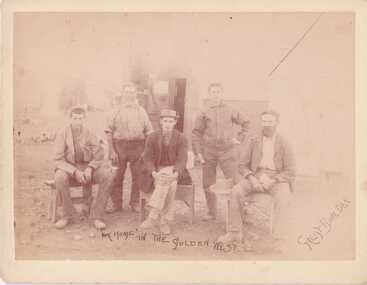
Photograph, GREAT BUILDER
SEPIA PHOTOGRAPH FIVE MEN - THREE SEATED, TWO STANDING. ON REVERSE SIDE OF PHOTOGRAPH - MAYBE GRANDPA OGIER SON OF FREDERICK WITH HAT ON AND MAYBE HARRY CARTER [SON IN LAW]"OUR HOME IN THE GOLDEN WEST" GREAT BUILDERphotography, early citizens, golden west, great boulder -
Clunes Museum
Clothing - GLOVES
WHITE MANMADE FIBRE, LADIES GLOVES, SIZE 6 1/2. "KAYSER" NYLON. MADE IN WEST GERMANY. COVERED BUTTON AT SIDE OF GLOVE AS DECORATIONcostume accessories, accessories - ladies, cloves -
Clunes Museum
Clothing - GLOVES
PAIR OF BONE COLOURED MANMADE FIBRE (DOUBLE WOVEN NYLON) LADIES GLOVES MADE IN WEST GERMANY. EMBROIDERED ON EACH OUTER SIDE OF GLOVE costume accessories female, costumes, accessories - ladies, gloves -
 Clunes Museum
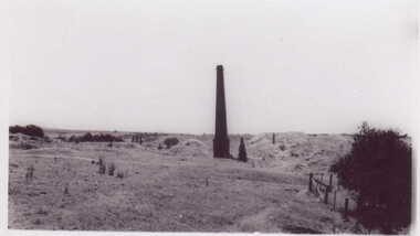
Photograph
... REVERSE SIDE MINE CHIMNEY JUST WEST OF SANDHEAPS FROM... history photography photographs REVERSE SIDE MINE CHIMNEY JUST ...SMALL BLACK AND WHITE PHOTOGRAPH OF MINE CHIMNEY PORT PHILIP MINEREVERSE SIDE MINE CHIMNEY JUST WEST OF SANDHEAPS FROM TALBOT ROAD LOOKING NORTH TO CHIMNEY OF PORT PHILIP MINElocal history, photography, photographs -
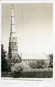 Stawell Historical Society Inc
Photograph, St. Matthew’s Presbyterian Church looking West. Rose Series P-4883
Side view of St. Matthew’s Church with wooden fence. Looking west.St Matthew's Presbyterian Church viewed from the side with a wooden picket fence. Photograph similar to 121.5 judging by the similar trees around the church.stawell religion -
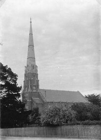 Stawell Historical Society Inc
Photograph, St. Matthew’s Presbyterian Church looking West
Side view of St. Matthew’s Church with wooden fence. Looking west.St Matthew's Presbyterian Church viewed from the side with a wooden picket fence. Photograph similar to 121.5 judging by the similar trees around the church.stawell religion -
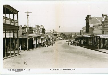 Stawell Historical Society Inc
Photograph, Main Street Stawell looking west towards the Post Office Rose series 1639
This photograph is of Main Street Stawell lookingwest around c 1930's. The photo was taken from the Bull and Mouth Hotel whis is on the left side and other business. On the road are a few people and cars.Black and white Postcard Rose Series 1639 Looking down Main St From the Bull and Mouth Hotel Partially visable on the left. The Rose series, P 1639 Main Street, Stawell, Victoriastawell business shops streetscape -
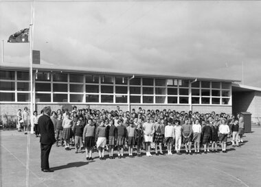 Stawell Historical Society Inc
Photograph, Stawell West Primary School Number 4934 at Assembly
... to the left side. Stawell West Primary School Number 4934 at Assembly ...Creased taken late 1950's or early 1960'sB/W Phot Students on grounds at Assembly. Flag full mast. Teacher to the left side.education -
 Stawell Historical Society Inc
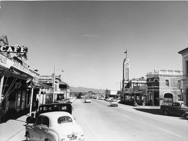
Photograph, Main Street Stawell looking West towards the Town Hall, on the right c 1960's
Main Street Stawell looking West including Town Hall Shops and Motor Vehicles c 1960's. This photo was taken by M. Robson before being donated to the society. The photo of Main St. was taken before it was made into a Mall, now know as "Gold Reef Mall". The street reopened to traffic in 2005.Black & white photograph of Main St Stawell looking towards the Grampians. The view includes the Town Hall & Bank of Australia on the right, with shops either side and two vehicles travelling along the road with vehicles parked along the street c 1960's.stawell business streetscape -
 Stawell Historical Society Inc
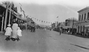
Photograph, Main Street Stawell at Easter looking West with the Post Office on the right
Easter celebrations in Main St. Stawell. The photo is taken looking west c 1930. Post Office building is on the right with bunting hanging over the building and down the main street. The street must have been closed to traffic as people are walking up and down the street. A woman with two children are on the left of the photo. One small black & white photo and a enlarged copy. The photograph was taken at Easter celebrations in Main street looking west. A woman with 2 children either side of her on the left of the photograph. Bunting is hanging along the Main street.Main St ? Datestawell business streetscape -
 Stawell Historical Society Inc
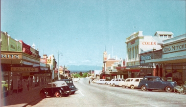
Photograph, Main Street Stawell looking West with Geo. Mitchell shop on the right c 1955 -- Coloured
Coloured photo c 1955 Main Street Scene looking West. Geo Mitchell Draper on right with Coles and Macrows. On the left E. Dale & Co. shop sign is visible. Either side of the street has cars parked at an angle with a soft canopy car parked on the left side.Colour photograph looking down Main St Stawell with the Grampians in the distance c 1955. This coloured photo has shops either side in view and cars parked at an angle along the street. Coles, Macrows and Geo. Mitchell shops are on the right and E. Dale & Co shop sigh is visible on the left.stawell business streetscape -
 Stawell Historical Society Inc
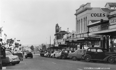
Photograph, Main Street Stawell looking West with the Coles Variety Store on the right c 1950 -- Postcard
Post Card Valentines c 1950. Main Street Stawell looking West. The view show cars parked at an angle down Main St. and shops mainly along one side. The town hall clock can be seen above the building with the Coles sign, Macrows and Geo on the right hand edge.Valentine's Post card of Main St., Stawell looking West. The scene is of many 1950 cars parked along the street with Coles Variety Store, Macrows and Geo stores dominating to the right of the photo."VII" "Main Street, Stawell" (on the front) "Valentine's Post Card sending you greetings" (on the back)stawell business streetscape -
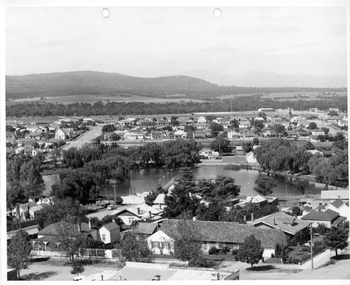 Stawell Historical Society Inc
Photograph, Cato Lake from top of clock tower c 1965
Photo taken from top of clock tower c 1965 looking South West. Black Range in background. Stawell West State School is in the far top right just in front of a band of trees. The swimming pool is hidden by pine trees in the center of the lake and identified but a line of flag posts either side of the pool.Aerial black and white view of Cato lake. One photo is original and the other a copy. The photo was taken from the top of the clock tower looking South West. c 1965.stawell, streetscape -
 Whitehorse Historical Society Inc.
Photograph, Site of Barnard's Corner Store
Laser Print of black and white photo of Site of Barnard's Corner Store (2 copies) Boronia Road and Canterbury Road, Vermont. (Mounted) Barnard's Store was on the south-west corner of Canterbury Road and L.L. Vale Road (Boronia Road) Vermont. The old store was run by Miss Barnard. Mr Barnard had a Farriers Shop at the back of the store. The white gates on back centre of photograph in Canterbury Road is entrance to Uplands, home of Edward Bishop and Dr. Stephens. White fence on right hand side of photograph is entrance to home of Mr. & Mrs. Tilson who was a market gardener and orchardist.barnards corner store, uplands, vermont, stephens, dr., tilson, mr., tilson mrs, bishop, edward -
 Whitehorse Historical Society Inc.
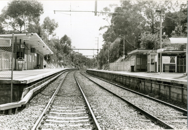
Photograph, Railway Station, Heatherdale|Railway Stations, 2000
Produced as one of a series of 24 prints commissioned by Nunawading & District Historical Society -|Theme: Intersections of Mitcham and Nunawading 2000/2001.|See also Series by P. Simmenauer on the same theme.Black and white photograph - print and negative of Heatherdale Railway Station, viewed from the Heatherdale Rail Crossing. L-R West bound station platform for travel to City of Melbourne, next station is Mitcham. Right hand side Eastbound platform - next stop Ringwood, where some trains travel S.E. to Belgrave and some N.E. to Lilydale. Heatherdale is last station in fare Zone 2 and 1st station in Fare Zone 3. Note Telstra Phonebox on platformheatherdale railway station -
 Whitehorse Historical Society Inc.
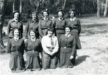
Photograph, Nunawading Brownie Guiders in Mitcham Shopping Centre, Late 1950s - Early 1960s
... on the north side of Whitehorse Road, west of Mitcham Road.The traders... Shopping Centre. Photo shows the Mitcham shops on the north side ...Black and white photo of Nunawading Brownie Guiders at a parade in Mitcham Shopping Centre. Photo shows the Mitcham shops on the north side of Whitehorse Road, west of Mitcham Road.The traders shown in the photo, left to right, Claude Richards-Draper; D.G.Williamson - Fruiterer; Bob Dorien - Chemist in same building as Williamson; Hay and Corn Store - ???; and Norman & Sons-Grocer.Across Mitcham Road is Barrie George - Milk Bar; Fish Shop- ??? and Ken Herbert - Grocer; the Mitcham Memorial Hall is on the east side.It is estimated that the photo was taken in the late 1950s or early 1960s.richards, claude, dorien, bob, williamson, d.g., norman & sons, george, barrie, herbert, ken, fish shops, mitcham memorial hall, gardiner, shirley, floyd, peg, quick, judith, elsworth, jean, lynette, brown, evelynne, hogben, pam, sue, yarrow, erica -
 Whitehorse Historical Society Inc.
Photograph, Narmara Primary School, 13/01/1994 12:00:00 AM
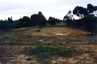
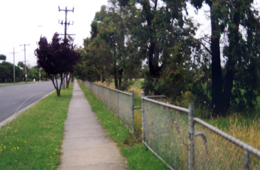
Coloured photo of Narmara Primary School looking East from North West corner, showing site of removal of school buildings. School on North side of Highbury Road between Middleborough Road and Blackburn Road. Since demolished and site developed for housing.narmara primary school, warner, philip -
 Whitehorse Historical Society Inc.
Photograph, Narmara Primary School, 13/01/1994 12:00:00 AM
Coloured photo of Narmara Primary School, looking South from North West corner. School on North side of Highbury Road between Middleborough Road and Blackburn Road. Since demolished and site developed for housing.narmara primary school, warner, philip -
 Whitehorse Historical Society Inc.
Photograph, Narmara Primary School, 13/01/1994 12:00:00 AM
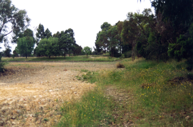
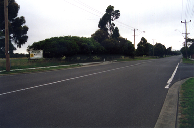
Coloured photo of Narmara Primary School, looking West along Highbury Road. School on North side of Highbury Road between Middleborough and Blackburn Roads. Since demolished and site developed for housing.narmara primary school, warner, philip -
 Whitehorse Historical Society Inc.
Photograph, Narmara Primary School, 13/01/1994 12:00:00 AM
Coloured photo of Narmara Primary School site looking West along Highbury Road. School on North side of Highbury Road between Middleborough and Blackburn Roads. Since demolished and site developed for housing.narmara primary school, warner, philip -
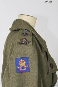 Whitehorse Historical Society Inc.
Clothing - Coat Army, c1939
World War Two Army uniform|Worn by Captain Noel WestWorld War two|Australian War Graves UnitOne khaki woolen army great coat, wide lapels wide cuffs, double breasted, four sets of medal buttons. Wide pocket cuffs on two external pockets. Epaulets on each shoulder with Australian badge and 3 pips and one button. Badge on right hand shoulder- blue with crown '' British Commonwealth Forces''. Collar with neck flaps with four bakelite buttons. Pleat on top of coat with belt with three metal buttons. Vent on skirt of coat with two bakelite buttons.Back of coat is lined to the vent, sides are fully lined with cotton fabric, sleeves are fully lined. One deep pocket on left side with one bakelite button. Fabric hook on back of collar''MTS'' N.WEST. British Commonwealth Forcescostume, male uniform, military