Showing 1615 items matching "zones"
-
 National Vietnam Veterans Museum (NVVM)
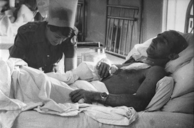
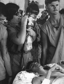
Photograph, Gibbons, Denis, Wounded Trooper
Denis Gibbons (1937 – 2011) Trained with the Australian Army, before travelling to Vietnam in January 1966, Denis stayed with the 1st Australian Task Force in Nui Dat working as a photographer. For almost five years Gibbons toured with nine Australian infantry battalions, posting compelling war images from within many combat zones before being flown out in late November 1970 after sustaining injuries. The images held within the National Vietnam Veterans Museum make up the Gibbons Collection.A black and white photograph at the 1st Australian Field Hospital, Vung Tau, South Vietnam, Ward Sister Lt Ann Wright applies treatment to a wounded Special Air Services Digger Trooper Rossiter, wounded during a hot extraction out of enemy territory.photograph, 1st australian field hospital, vung tau, lt ann wright, sas, digger, trooper rossiter, gibbons collection catalogue, special air services, wounded serviceman, nurses -
 National Vietnam Veterans Museum (NVVM)
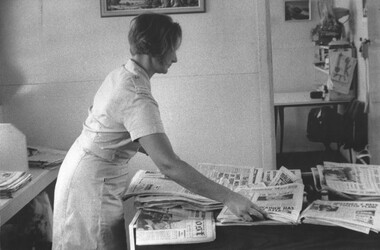
Photograph, Gibbons, Denis, News and a Cold Drink
Denis Gibbons (1937 – 2011) Trained with the Australian Army, before travelling to Vietnam in January 1966, Denis stayed with the 1st Australian Task Force in Nui Dat working as a photographer. For almost five years Gibbons toured with nine Australian infantry battalions, posting compelling war images from within many combat zones before being flown out in late November 1970 after sustaining injuries. The images held within the National Vietnam Veterans Museum make up the Gibbons Collection.A black and white photograph At 1st Australian Field Hospital, Vung Tau, South Vietnam, Red Cross Member Rosemary Griggs organises the Red Cross hut for the day of patient and general visitors. The Diggers could catch up on all the news from home over a cool drinkphotograph, 1st australian field hospital, vung tau, red cross, rosemary griggs, gibbons collection catalogue, diggers, red cross hut -
 National Vietnam Veterans Museum (NVVM)
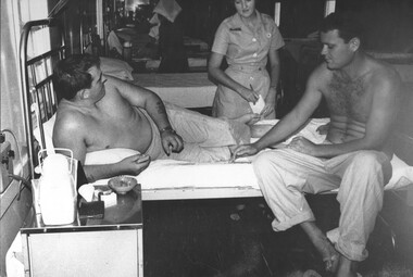
Photograph, Gibbons, Denis, Doing The Rounds
Denis Gibbons (1937 – 2011) Trained with the Australian Army, before travelling to Vietnam in January 1966, Denis stayed with the 1st Australian Task Force in Nui Dat working as a photographer. For almost five years Gibbons toured with nine Australian infantry battalions, posting compelling war images from within many combat zones before being flown out in late November 1970 after sustaining injuries. The images held within the National Vietnam Veterans Museum make up the Gibbons Collection.A black and white photograph of Red Cross girl Carol Eacott takes down the requirements of two patients as she does her rounds in the ward at the 1st Australian Field Hospital. Vung Tau, South Vietnam. ANZAC Sister can be seen treating patients in the background.photograph, 1st australian field hospital, carol eacott (red cross), red cross, gibbons collection catalogue, vung tau, anzac sister -
 National Vietnam Veterans Museum (NVVM)
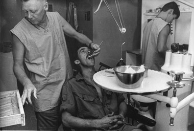
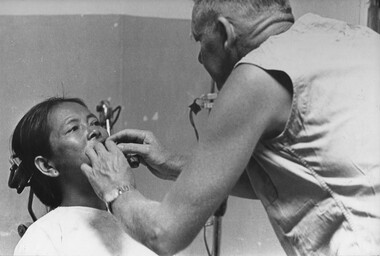
Photograph, Gibbons, Denis, Dental Services 1
Denis Gibbons (1937 – 2011) Trained with the Australian Army, before travelling to Vietnam in January 1966, Denis stayed with the 1st Australian Task Force in Nui Dat working as a photographer. For almost five years Gibbons toured with nine Australian infantry battalions, posting compelling war images from within many combat zones before being flown out in late November 1970 after sustaining injuries. The images held within the National Vietnam Veterans Museum make up the Gibbons Collection.A black and white photograph at the 1st Australian Field Hospital, Vung Tau, South Vietnam, Dentist works on a Digger patient while a dental assistant mixed filling material. Full dental services were available to the Digger under normal and battle circumstances.photograph, 1st australian field hospital, vung tau, dentists, digger, gibbons collection catalogue -
 National Vietnam Veterans Museum (NVVM)
Photograph, Gibbons, Denis, Adjusting the Drip Bottle
Denis Gibbons (1937 – 2011) Trained with the Australian Army, before travelling to Vietnam in January 1966, Denis stayed with the 1st Australian Task Force in Nui Dat working as a photographer. For almost five years Gibbons toured with nine Australian infantry battalions, posting compelling war images from within many combat zones before being flown out in late November 1970 after sustaining injuries. The images held within the National Vietnam Veterans Museum make up the Gibbons Collection.A black and white photograph at 1st Australian Field Hospital Medics Rob Swincer and Mick O'Halloran steady a stretcher as Capt Ann Hall adjusts the drip bottle for a wounded Digger being transported ambulance to be medivaced by RAAF transport back to Australiaphotograph, 1st australian field hospital, rob swincer (medic), mick o'halloran, digger, capt ann hall, raaf, c130 medivac flight, gibbons collection catalogue, medics, vung tau, wounded serviceman, nurses -
 National Vietnam Veterans Museum (NVVM)
Photograph, Gibbons, Denis, Catching Up
Denis Gibbons (1937 – 2011) Trained with the Australian Army, before travelling to Vietnam in January 1966, Denis stayed with the 1st Australian Task Force in Nui Dat working as a photographer. For almost five years Gibbons toured with nine Australian infantry battalions, posting compelling war images from within many combat zones before being flown out in late November 1970 after sustaining injuries. The images held within the National Vietnam Veterans Museum make up the Gibbons Collection.A black and white photograph of Capt Shirley Southwell (RAANC) and her brother Capt Terry Southwell 5th Battalion Royal Australian Regiment, snatch a few moments together as they watch the sick being loaded aboard ambulances for RAAF medivac C130 medivac transport to Australiaphotograph, 1st australian field hospital, raanc, nurse, capt shirley southwell, capt terry southwell, 5 rar, raaf, medivac, c130 medivac flight, gibbons collection catalogue, vung tau -
 National Vietnam Veterans Museum (NVVM)
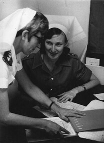
Photograph, Gibbons, Denis, Hand Over Report 2
Denis Gibbons (1937 – 2011) Trained with the Australian Army, before travelling to Vietnam in January 1966, Denis stayed with the 1st Australian Task Force in Nui Dat working as a photographer. For almost five years Gibbons toured with nine Australian infantry battalions, posting compelling war images from within many combat zones before being flown out in late November 1970 after sustaining injuries. The images held within the National Vietnam Veterans Museum make up the Gibbons Collection.A black and white photograph of ANZAC Nursing Sisters Lt Patricia Ferguson (RAANC), receives the hand over report from Capt Clare Jacobson (RNZANC) in the Sisters station of the Surgical Ward at the 1st Australian Field Hospital, Vung Tau, South Vietnam (May 1970) photograph, 1st australian field hospital, vung tau, lt patricia ferguson, capt clare jacobson, raanc, rnzanc, nurse, gibbons collection catalogue, surgical ward, sisters station -
 National Vietnam Veterans Museum (NVVM)
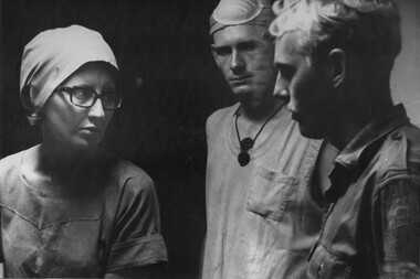
Photograph, Gibbons, Denis, Discussing a Problem
Denis Gibbons (1937 – 2011) Trained with the Australian Army, before travelling to Vietnam in January 1966, Denis stayed with the 1st Australian Task Force in Nui Dat working as a photographer. For almost five years Gibbons toured with nine Australian infantry battalions, posting compelling war images from within many combat zones before being flown out in late November 1970 after sustaining injuries. The images held within the National Vietnam Veterans Museum make up the Gibbons Collection.A black and white photograph at the 1st Australian Field Hospital, Vung Tau, South Vietnam, theatre sister Capt June Minchow and Medic Corporal Alex (Chuck) Berry discuss an operating theatre problem with another corporal Medic at the hospital.photograph, 1st australian field hospital, vung tau, medic, cpl alex (chuck) berry, capt june minchow, gibbons collection catalogue, nurses, operating theatre, medics -
 National Vietnam Veterans Museum (NVVM)
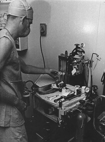
Photograph, Gibbons, Denis, Cpl Berry
Denis Gibbons (1937 – 2011) Trained with the Australian Army, before travelling to Vietnam in January 1966, Denis stayed with the 1st Australian Task Force in Nui Dat working as a photographer. For almost five years Gibbons toured with nine Australian infantry battalions, posting compelling war images from within many combat zones before being flown out in late November 1970 after sustaining injuries. The images held within the National Vietnam Veterans Museum make up the Gibbons Collection.A black and white photograph of Corporal (Chuck) Berry, adjusts the anaesthesia machine in the operating theatre at 1st Australian Field Hospital, Vung Tau, South Vietnam. The medics at the hospital were highly trained photograph, cpl alex (chuck) berry, 1st australian field hospital, vung tau, medic, gibbons collection catalogue, operating theatre -
 National Vietnam Veterans Museum (NVVM)
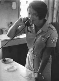
Photograph, Gibbons, Denis, Rosemary Griggs
Denis Gibbons (1937 – 2011) Trained with the Australian Army, before travelling to Vietnam in January 1966, Denis stayed with the 1st Australian Task Force in Nui Dat working as a photographer. For almost five years Gibbons toured with nine Australian infantry battalions, posting compelling war images from within many combat zones before being flown out in late November 1970 after sustaining injuries. The images held within the National Vietnam Veterans Museum make up the Gibbons Collection.A black and white photograph of one of the Red Cross Staff at the 1st Australian Field Hospital, Vung Tau, South Vietnam, Rosemary Griggs mans the telephone in the Red Cross Hut. photograph, red cross, 1st australian field hospital, vung tau, rosemary griggs, gibbons collection catalogue, red cross hut -
 National Vietnam Veterans Museum (NVVM)
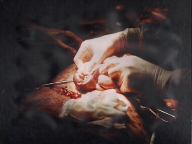
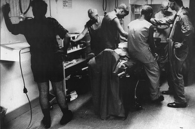
Photograph, Gibbons, Denis, Laporotomy
Denis Gibbons (1937 – 2011) Trained with the Australian Army, before travelling to Vietnam in January 1966, Denis stayed with the 1st Australian Task Force in Nui Dat working as a photographer. For almost five years Gibbons toured with nine Australian infantry battalions, posting compelling war images from within many combat zones before being flown out in late November 1970 after sustaining injuries. The images held within the National Vietnam Veterans Museum make up the Gibbons Collection.A coloured photograph at the 1st Australian Field Hospital, Vung Tau, Surgeon Ed Carr conducts a laporotomy on a mine explosion patient assisted by Wg Audio, CDr Alan Beech and medic Cpl Peter Whittle. The pressure wave from the mine explosion causes multiple perforations of the gut.photograph, 1st australian field hospital, surgeon ed carr, wg audio, cdr alan beech, cpl peter whittle, gibbons collection catalogue, surgeons, denis gibbons, vung tau, medics -
 National Vietnam Veterans Museum (NVVM)
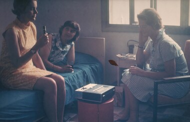
Photograph, Gibbons, Denis, Letter Tape Home
Denis Gibbons (1937 – 2011) Trained with the Australian Army, before travelling to Vietnam in January 1966, Denis stayed with the 1st Australian Task Force in Nui Dat working as a photographer. For almost five years Gibbons toured with nine Australian infantry battalions, posting compelling war images from within many combat zones before being flown out in late November 1970 after sustaining injuries. The images held within the National Vietnam Veterans Museum make up the Gibbons Collection.A coloured photograph of a combined "letter tape" back home to Australia for the 8 Field Ambulance Hospital Red Cross girls, Jean Debelle, Winsome Ayliffe and Janice Webb. These short tapes give the girls a feeling of being home to be able to talk to their family and friendsphotograph, 8 field ambulance hospital, red cross, jean debelle (red cross), winsome ayliffe (red cross), janice webb (red cross), gibbons collection catalogue, denis gibbons -
 National Vietnam Veterans Museum (NVVM)
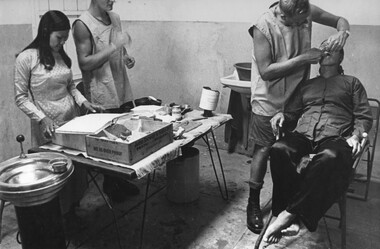
Photograph, Gibbons, Denis, Dental Services 3
Denis Gibbons (1937 – 2011) Trained with the Australian Army, before travelling to Vietnam in January 1966, Denis stayed with the 1st Australian Task Force in Nui Dat working as a photographer. For almost five years Gibbons toured with nine Australian infantry battalions, posting compelling war images from within many combat zones before being flown out in late November 1970 after sustaining injuries. The images held within the National Vietnam Veterans Museum make up the Gibbons Collection.A black and white photograph of 1st Australian Field Hospital, Vung Tau, South Vietnam. Dentist works on a female Vietnamese patient while a dental assistant and a civilian female Vietnamese aide look on. Full dental services were available to the staff and civilian Vietnamese employees.photograph, 1st australian field hospital, vung tau, vietnamese workers, dentists, gibbons collection catalogue, denis gibbons -
 National Vietnam Veterans Museum (NVVM)
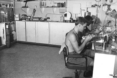
Photograph, Gibbons, Denis, False Teeth
Denis Gibbons (1937 – 2011) Trained with the Australian Army, before travelling to Vietnam in January 1966, Denis stayed with the 1st Australian Task Force in Nui Dat working as a photographer. For almost five years Gibbons toured with nine Australian infantry battalions, posting compelling war images from within many combat zones before being flown out in late November 1970 after sustaining injuries. The images held within the National Vietnam Veterans Museum make up the Gibbons Collection.A black and white photograph at 1st Australian Field Hospital, Vung Tau, South Vietnam, two Dental Technicians work on the construction of sets of false teeth in their well equiped Dental Laboratory. These technicians had the capability to construct any work ordered by the dentist.photograph, 1st australian field hospital, vung tau, dentists, dental laboratory, dental technicians, gibbons collection catalogue -
 National Vietnam Veterans Museum (NVVM)
Photograph, Gibbons, Denis, Dental Services 2
Denis Gibbons (1937 – 2011) Trained with the Australian Army, before travelling to Vietnam in January 1966, Denis stayed with the 1st Australian Task Force in Nui Dat working as a photographer. For almost five years Gibbons toured with nine Australian infantry battalions, posting compelling war images from within many combat zones before being flown out in late November 1970 after sustaining injuries. The images held within the National Vietnam Veterans Museum make up the Gibbons Collection.A black and white photograph at the 1st Australian Field Hospital, Vung Tau, South Vietnam. Dentist works on a Vietnamese patient while a dental assistant and female Vietnamese aide look on. Full dental services were available to the staff and civilian Vietnamese employees.photograph, 1st australian field hospital, vung tau, dentists, vietnamese workers, gibbons collection catalogue -
 National Vietnam Veterans Museum (NVVM)
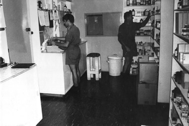
Photograph, Gibbons, Denis, Pharmacy
Denis Gibbons (1937 – 2011) Trained with the Australian Army, before travelling to Vietnam in January 1966, Denis stayed with the 1st Australian Task Force in Nui Dat working as a photographer. For almost five years Gibbons toured with nine Australian infantry battalions, posting compelling war images from within many combat zones before being flown out in late November 1970 after sustaining injuries. The images held within the National Vietnam Veterans Museum make up the Gibbons Collection.A black and white photograph at the 1st Australian Field Hospital, Vung Tau, South Vietnam, Pharmacist Lt Roger Nation prepares prescriptions for patients in the hospital while a pharmacy assistant collects the drugs to be issued.photograph, 1st australian field hospital, vung tau, lt roger nation, pharmacy, gibbons collection catalogue, pharmacists -
 National Vietnam Veterans Museum (NVVM)
Photograph, Gibbons, Denis, More Wounded NVA/VC 2
Denis Gibbons (1937 – 2011) Trained with the Australian Army, before travelling to Vietnam in January 1966, Denis stayed with the 1st Australian Task Force in Nui Dat working as a photographer. For almost five years Gibbons toured with nine Australian infantry battalions, posting compelling war images from within many combat zones before being flown out in late November 1970 after sustaining injuries. The images held within the National Vietnam Veterans Museum make up the Gibbons Collection.A black and white photograph of Medics and Intelligence Officers meet and unload a secondAmerican Dustoff medical evacuation helicopter bringing wounded NVA/VietCong enemy from the NVA/VietCong K76A Hospital wards captured on the Nui May Tao Mountain by 6 RAR/NZ (ANZAC)photograph, intelligence officers, dustoff, nva/vc, k76a hospital, 6 rar/nz, nui may tao mountain, operation marsden, gibbons collection catalogue, anzac, medics, denis gibbons -
 National Vietnam Veterans Museum (NVVM)
Photograph, Gibbons, Denis, Preparing for Theatre
Denis Gibbons (1937 – 2011) Trained with the Australian Army, before travelling to Vietnam in January 1966, Denis stayed with the 1st Australian Task Force in Nui Dat working as a photographer. For almost five years Gibbons toured with nine Australian infantry battalions, posting compelling war images from within many combat zones before being flown out in late November 1970 after sustaining injuries. The images held within the National Vietnam Veterans Museum make up the Gibbons Collection.A black and white photograph of Triage in the 1st Australian Field Hospital, Vung Tau, South Vietnam preparing a "Dustoff" wounded Digger prior to going to theatre. Lt Col Ian Miller (seated) and Dr Andrew Smith (in flying suit) are assisted by 1st Australian Field Hospital Medicsphotograph, 1st australian field hospital, vung tau, dustoff, digger, lt col ian miller (doctor), doctor, andrew smith (doctor), medic, gibbons collection catalogue, 1st australian field hospital medics, denis gibbons -
 National Vietnam Veterans Museum (NVVM)
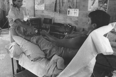
Photograph, Gibbons, Denis, Physiotherapy 2
Denis Gibbons (1937 – 2011) Trained with the Australian Army, before travelling to Vietnam in January 1966, Denis stayed with the 1st Australian Task Force in Nui Dat working as a photographer. For almost five years Gibbons toured with nine Australian infantry battalions, posting compelling war images from within many combat zones before being flown out in late November 1970 after sustaining injuries. The images held within the National Vietnam Veterans Museum make up the Gibbons Collection.A black and white photograph of Physiotherapist Lt Diane Skewes assists a patient, while a second Digger lies face down waiting his turn for treatment in the Physio Hut at the 1st Australian Field Hospital, Vung Tau, South Vietnam1st australian field hospital, vung tau, physiotherapy, lt diane skewes, gibbons collection catalogue, diggers, wounded servicemen, physio hut -
 National Vietnam Veterans Museum (NVVM)
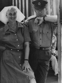
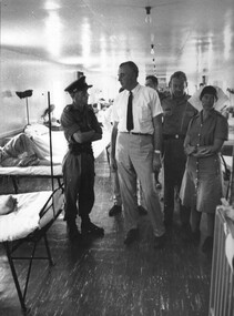
Photograph, Gibbons, Denis, Gough Whitlam 2
Denis Gibbons (1937 – 2011) Trained with the Australian Army, before travelling to Vietnam in January 1966, Denis stayed with the 1st Australian Task Force in Nui Dat working as a photographer. For almost five years Gibbons toured with nine Australian infantry battalions, posting compelling war images from within many combat zones before being flown out in late November 1970 after sustaining injuries. The images held within the National Vietnam Veterans Museum make up the Gibbons Collection.A black and white photograph of the Commanding Officer at the 1st Australian Field Hospital, Vung Tau, South Vietnam, Lt Col Hurley escorts the Leader of the Opposition Mr Gough Whitlam during a visit. photograph, 1st australian field hospital, lt col ray hurley, gough whitlam, vung tau, gibbons collection catalogue, denis gibbons, labour opposition australian government, nurses -
 National Vietnam Veterans Museum (NVVM)
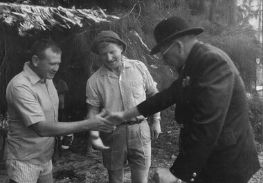
Photograph, Gibbons, Denis, Welcoming Guests
Denis Gibbons (1937 – 2011) Trained with the Australian Army, before travelling to Vietnam in January 1966, Denis stayed with the 1st Australian Task Force in Nui Dat working as a photographer. For almost five years Gibbons toured with nine Australian infantry battalions, posting compelling war images from within many combat zones before being flown out in late November 1970 after sustaining injuries. The images held within the National Vietnam Veterans Museum make up the Gibbons Collection.A black and white photograph at the 1st Australian Field Hospital, Vung Tau, South Vietnam. Medic in a bowler hat welcoming guests to a party at the unit in April 1970, in the centre is the Australian Force Vietnam Provost Marshall Maj Dick Gormanphotograph, 1st australian field hospital, vung tau, medic, provost marshall, maj dick gorman, gibbons collection catalogue, australian force vietnam, denis gibbons -
 National Vietnam Veterans Museum (NVVM)
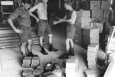
Photograph, Gibbons, Denis, Quartermasters Store
Denis Gibbons (1937 – 2011) Trained with the Australian Army, before travelling to Vietnam in January 1966, Denis stayed with the 1st Australian Task Force in Nui Dat working as a photographer. For almost five years Gibbons toured with nine Australian infantry battalions, posting compelling war images from within many combat zones before being flown out in late November 1970 after sustaining injuries. The images held within the National Vietnam Veterans Museum make up the Gibbons Collection.A black and white photograph at 1st Australian Field Hospital, Vung Tau, South Vietnam, a Digger in the Quartermaster's store appears to be making a point to one of his colleagues while a Corporal contemplates the packages on the floor.photograph, quartermasters store, 1st australian field hospital, vung tau, digger, gibbons collection catalogue -
 National Vietnam Veterans Museum (NVVM)
Photograph, Gibbons, Denis, Stores Check
Denis Gibbons (1937 – 2011) Trained with the Australian Army, before travelling to Vietnam in January 1966, Denis stayed with the 1st Australian Task Force in Nui Dat working as a photographer. For almost five years Gibbons toured with nine Australian infantry battalions, posting compelling war images from within many combat zones before being flown out in late November 1970 after sustaining injuries. The images held within the National Vietnam Veterans Museum make up the Gibbons Collection.A black and white photograph of Stores staff in the Quartermasters Store at 1st Australian Field Hospital, Vung Tau, South Vietnam, check and stack stores. The constant use and deterioration of stores required constant vigilence by the stores staff to maintain hospital requirements.photograph, quartermasters store, 1st australian field hospital, vung tau, digger, gibbons collection catalogue, denis gibbons -
 National Vietnam Veterans Museum (NVVM)
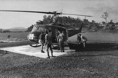
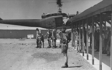
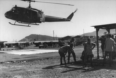
Photograph, Gibbons, Denis, Waiting for Incoming Dustoff 4
Denis Gibbons (1937 – 2011) Trained with the Australian Army, before travelling to Vietnam in January 1966, Denis stayed with the 1st Australian Task Force in Nui Dat working as a photographer. For almost five years Gibbons toured with nine Australian infantry battalions, posting compelling war images from within many combat zones before being flown out in late November 1970 after sustaining injuries. The images held within the National Vietnam Veterans Museum make up the Gibbons Collection.A black and white photograph of medics at the 1st Australian Field Hospital turn their heads to escape rotor wash as an American "Dustoff" medivac evacuation helicopter lands with a battle casuality. The Medics are ready to transfer the casavac to the hospital triage for assessment.photograph, 1st australian field hospital, vung tau, dustoff, medivac, gibbons collection catalogue, medics, wounded servicemen, denis gibbons -
 National Vietnam Veterans Museum (NVVM)
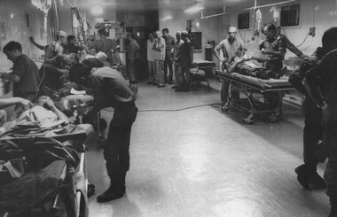
Photograph, Gibbons, Denis, Six Triage Bays
Denis Gibbons (1937 – 2011) Trained with the Australian Army, before travelling to Vietnam in January 1966, Denis stayed with the 1st Australian Task Force in Nui Dat working as a photographer. For almost five years Gibbons toured with nine Australian infantry battalions, posting compelling war images from within many combat zones before being flown out in late November 1970 after sustaining injuries. The images held within the National Vietnam Veterans Museum make up the Gibbons Collection.A black and white photograph of triage at full operational strength, with all six bays working, at the 1st Australian Field Hospital, Vung Tau, South Vietnam. In the last two of the bays wounded female and male VietCong are assessed at the same time as four wounded diggers.photograph, 1st australian field hospital, vung tau, viet cong, gibbons collection catalogue, denis gibbons, triage, diggers, wounded servicemen, female viet cong prisoner, male viet cong prisoner -
 National Vietnam Veterans Museum (NVVM)
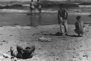
Photograph, Gibbons, Denis, Back Beach 2
Denis Gibbons (1937 – 2011) Trained with the Australian Army, before travelling to Vietnam in January 1966, Denis stayed with the 1st Australian Task Force in Nui Dat working as a photographer. For almost five years Gibbons toured with nine Australian infantry battalions, posting compelling war images from within many combat zones before being flown out in late November 1970 after sustaining injuries. The images held within the National Vietnam Veterans Museum make up the Gibbons Collection.A black and white photograph of Private Dave Henderson, wounded forward scout from 8 RAR, enjoys a paddle with a patient mate from the 1st Australian Field Hospital, Vung Tau, South Vietnam, while another patient looks on. Two other patients enjoy the open air and sun.photograph, pte dave henderson, 8 rar, 1st australian field hospital, vung tau, back beach, gibbons collection catalogue, denis gibbons, wounded servicemen -
 National Vietnam Veterans Museum (NVVM)
Photograph, Gibbons, Denis, Waiting for Treatment 2
Denis Gibbons (1937 – 2011) Trained with the Australian Army, before travelling to Vietnam in January 1966, Denis stayed with the 1st Australian Task Force in Nui Dat working as a photographer. For almost five years Gibbons toured with nine Australian infantry battalions, posting compelling war images from within many combat zones before being flown out in late November 1970 after sustaining injuries. The images held within the National Vietnam Veterans Museum make up the Gibbons Collection.A black and white photograph of Nursing Sister Captain Shirley Southwell answers the telephone as she mans the regimental aid post the 1st Australian Field Hospital, Vung Tau, South Vietnam while diggers wait their turn for assessment/treatmentphotograph, 1st australian field hospital, vung tau, capt shirley southwell, gibbons collection catalogue, diggers, denis gibbons -
 National Vietnam Veterans Museum (NVVM)
Photograph, Gibbons, Denis, Waiting for Incoming Dustoff 3
Denis Gibbons (1937 – 2011) Trained with the Australian Army, before travelling to Vietnam in January 1966, Denis stayed with the 1st Australian Task Force in Nui Dat working as a photographer. For almost five years Gibbons toured with nine Australian infantry battalions, posting compelling war images from within many combat zones before being flown out in late November 1970 after sustaining injuries. The images held within the National Vietnam Veterans Museum make up the Gibbons Collection.A black and white photograph - 1st Australian Field Hospital, Vung Tau, South Vietnam, on the left Medics Ron Gillespie and Tony Green turn to avoid the rotor wash from the incoming "Dustoff" helicopter at the Vampire Helicopter pad.photograph, 1st australian field hospital, vung tau, tony green (medic), ron gillespie (medic), dustoff, vampire helicopter pad, gibbons collection catalogue, medics -
 National Vietnam Veterans Museum (NVVM)
Photograph, Gibbons, Denis, Waiting for Treatment 1
Denis Gibbons (1937 – 2011) Trained with the Australian Army, before travelling to Vietnam in January 1966, Denis stayed with the 1st Australian Task Force in Nui Dat working as a photographer. For almost five years Gibbons toured with nine Australian infantry battalions, posting compelling war images from within many combat zones before being flown out in late November 1970 after sustaining injuries. The images held within the National Vietnam Veterans Museum make up the Gibbons Collection.A black and white photograph of Nursing Sister Capt Shirley Southwell answers the telephone as she mans the regimental aid post the 1st Australian Field Hospital, Vung Tau, South Vietnam while diggers wait their turn for assessment/treatment.photograph, 1st australian field hospital, vung tau, capt shirley southwell, gibbons collection catalogue, diggers -
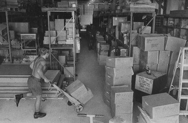 National Vietnam Veterans Museum (NVVM)
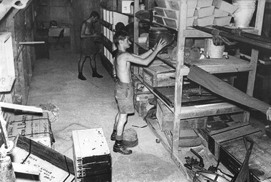
Photograph, Gibbons, Denis, Quartermasters Store 1
Denis Gibbons (1937 – 2011) Trained with the Australian Army, before travelling to Vietnam in January 1966, Denis stayed with the 1st Australian Task Force in Nui Dat working as a photographer. For almost five years Gibbons toured with nine Australian infantry battalions, posting compelling war images from within many combat zones before being flown out in late November 1970 after sustaining injuries. The images held within the National Vietnam Veterans Museum make up the Gibbons Collection.A black and white photograph of Diggers in the Quartermasters Store at 1st Australian Field Hospital, Vung Tau, South Vietnam sort and transport stores to their respective shelf area ready for stacking. photograph, 1st australian field hospital, vung tau, quartermasters store, gibbons collection catalogue, diggers, denis gibbons