Showing 25184 items
matching north
-
 Ballarat Tramway Museum
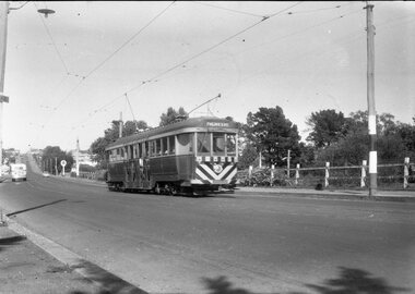
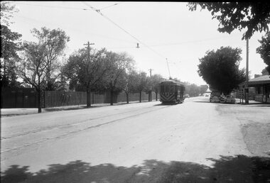
Negative - Geelong tram at Balliang St loop in Moorabool St, Laurie Gallop, early 1956
Photo shows a Geelong tram to North in Moorabool St at the Balliang St / Forser St loop in Moorabool St. In the background is a Caltex Service station and a bus. See also item 8299 for the trailing photograph.Yields information about the Geelong operations toward the closure of the tram system.Black and white Negative - 120 sizetramways, geelong, belmont, moorabool st, crossing loop -
 Melbourne Tram Museum
Document, Dennis Cliche, Employee News, 25 October 2007
This page is a letter to all Yarra Trams employees following a tram on tram collision in Flemington Rd, North Melbourne. It outlines the media stories and expresses appreciation to all employees for their work in delivering safe transport.Yields example of public relations between CEO and staff and concern when staff and passenger safety is breached.One singled side A4 size page printed with black ink A Message from the Chief Executive Officer, Yarra Tramsyarra trams, collision, ceo, senior management -
 Melbourne Tram Museum
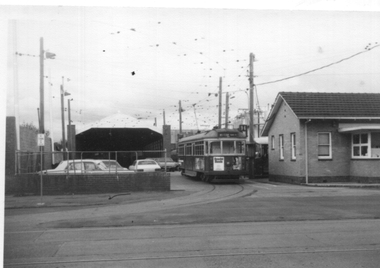
Photograph - W6 979 ready to leave North Fitzroy Depot, David Menzies, 1975
Black and white print of W6 979 ready to leave North Fitzroy Depot. Shows the depot offices and the depot behind and depot allocation board to the right of the tram. Tram about to run a route 96.Yields information about North Fitzroy Depot.Black and White photographs - printed on plain paper with photographers stamp and notes on rear.Has stamp of David Menzies on rear. and in ink details of photo.tramways, trams, mmtb, north fitzroy depot, w6 class, tram 979 -
 Melbourne Tram Museum
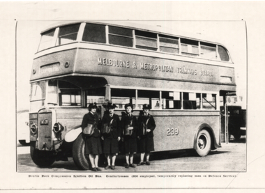
Photograph, Melbourne & Metropolitan Tramways Board (MMTB), "Double Deck Conductresses Ignition oil bus", 1942
Photograph shows four Second World War conductresses with ticket bags standing along MMTB Double Decker bus No. 239 at North Fitzroy Depot. The bus is fitted with headlight masks as a blackout measure. Yields information about Melbourne's Conductresses and double decker buses.Copy photograph - black and white - from the 1942 MMTB Annual Reporttramways, buses, world war 2, conductresses, double deck buses, bus 239, mmtb buses, leyland, td5c class -
 Melbourne Tram Museum
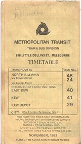
Ephemera - Timetable - route 48, The Met, Nov. 1943
Timetable published The Met or Metropolitan Transit - Nov. 1983 for the North Balywn tram route, giving route information sections, and timing points as well the timetables. Covers routes 24, 40, 41 and 29.Yields information about route 48 timetables.Timetable printed on yellow paper - 8 foldhas various notations in pencil.tramways, timetables, route 48, route 24, route 40, route 41, route 29 -
 Melbourne Tram Museum
Photograph - Cable tram track demolition - Nicholson St Fitzroy, 1954/55
Photograph shows cable tram track being removed in Nicholson St to the north of Gertrude St. The cable tram engine house can be seen in the far distance. Photographer and date unknown - 1954/55.Yields information about the removal of cable tram tracks in Nicholson Fitzroy during 1954/55.Black and white photograph with notes on rearOn rear in pencil number "141" in pencil in top right hand corner and "Removing cable track ? St?".tramways, cable trams, nicholson st, trackwork, demolition -
 Glen Eira Historical Society
Album - Album page, Ripponlea, 192 Hotham Street, Circa 1972
This photograph is part of the Caulfield Historical Album 1972. This album was created in approximately 1972 as part of a project by the Caulfield Historical Society to assist in identifying buildings worthy of preservation. The album is related to a Survey the Caulfield Historical Society developed in collaboration with the National Trust of Australia (Victoria) and Caulfield City Council to identify historic buildings within the City of Caulfield that warranted the protection of a National Trust Classification. Principal photographer thought to be Trevor Hart, member of Caulfield Historical Society. Most photographs were taken between 1966-1972 with a small number of photographs being older and from unknown sources. All photographs are black and white except where stated, with 386 photographs over 198 pages.From Victorian Heritage Database citation for Rippon Lea H0614 https://vhd.heritagecouncil.vic.gov.au/places/427(as at 23/10/2020) Rippon Lea was commenced in 1868 by Frederick Sargood, a most successful politician and merchant. He was born in England in 1834 and arrived in Melbourne in 1850. He soon joined his father's wholesale soft goods firm, spending some time as its manager on the goldfields. Sargood entered the Legislative Council in 1874. He was Victoria's first Minister for Defence in 1883. Sir Frederick Sargood was created CMG. In 1885 and KCMG in 1890 as a reward for his contribution to public life. He died suddenly in 1903. Rippon Lea was designed by the leading firm of architects, Reed and Barnes. Joseph Reed had travelled in Europe in 1863, including northern Italy. When he returned he introduced the use of polychromy. While not the first examples, Rippon Lea and the Independent Church in Collins Street were the best and set a fashion which became a distinctly Melbourne style, particularly used for houses and churches. Its popularity was possible because of the new availability of different coloured bricks. Reed's fine Lombardic Romanesque details soon became debased by others. As Sargood's family grew and his fortunes prospered, Rippon Lea was extended to include 33 rooms - a complete mansion. The cast iron porte cochere and the northern conservatory were added in 1897. The architects were Taylor and Fitts. The ballroom was added in 1882 and remodelled in 1889. Many alterations have changed the interior and exterior during the ownerships of Benjamin Nathan and later his daughter Mrs Louisa Jones in the 1930s and are in their own right of significance. Sir Thomas Bent owned the property from 1903 until 1911 but never lived there. He subdivided much of the land. The original garden dates from about 1868, and it seems that William Guilfoyle of the Botanic Gardens was involved. It was redesigned in a more natural style in the 1880s by Sargood and his head gardener, Adam Anderson. The lake, waterfalls, fernery, hill and grotto are balanced by mighty deciduous trees and conifers. These are interspersed with, but never dominated by Australian species such as eucalyptus and other exotics. The sinuous drive with its carefully prepared approach to the house is notable. The original vegetable gardens, orchard and outer paddocks no longer survive. The shade house is important as the largest known in Australia and possibly the world. Its curved plan and form of construction are particularly notable. It was built about 1884.Page 90 of Photograph Album with five photographs (one landscape and 4 portrait) of Ripponlea - two different views of the front entrance to the mansion, one of the front gates and two different views of the main residence.Handwritten: "Ripponlea" 192 Hotham Street [top right] / North [under top left photo] / Neg 255 Dec 1972 MAIN DRIVE [under bottom left photo] / Neg 238 8 OCT 1966 [under middle right photo] / 88 [bottom right]trevor hart, elsternwick, mansion, hotham street, frederick sargood, reed and barnes, cast iron porte cochere, conservatory, 1860's, 1890's, ballroom, 1880's, benjamin nathan, louisa jones, thomas bent, sir thomas bent, william guilfoyle, adam anderson, lake, grotto, shade house, portico, ripponlea, victorian, sir frederick sargood, architects, polychrome bricks, lombardic romanesque architectural style, rippon lea, taylor and fitts, land subdivisions, gardens, drives, vegetable gardens, orchards -
 Federation University Historical Collection
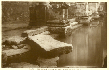
Postcard - Sepia, The Diving Stone in the Great Roman Bath, Bath, Somerset
The Great Bath is a massive pool, lined with 45 sheets of lead, and filled with hot spa water. It once stood in an enormous barrel-vaulted hall that rose to a height of 40 metres. For many Roman visitors this may have been the largest building they had ever entered in their life. The bath is 1.6 metres deep, which was ideal for bathing, and it has steps leading down on all sides. Niches around the baths would have held benches for bathers and possibly small tables for drinks or snacks. A large flat slab of stone is set across the point where hot water flows into the bath. It is known today as the diving stone. The Roman Baths complex is a site of historical interest in the English city of Bath. The house is a well-preserved Roman site for public bathing. The Roman Baths themselves are below the modern street level. There are four main features: the Sacred Spring, the Roman Temple, the Roman Bath House and the Museum, holding finds from Roman Bath. The buildings above street level date from the 19th century. Sepia postcard of a section of the Great Roman Bath at Bath, Somerset featuring the Diving Stone.printed verso: The Diving Stone in the great roman bath. The Diving stone, at the north-west corner of the great Roman Bath, still shows where the feet of bygone bathers wore away its surface. The hot mineral waters flowed into the bath through a channel under this stone. chatham-holmes family collection, bath, great roman bath, swimming pool -
 Ringwood and District Historical Society
Newspaper, Scrapbook Clipping, Library Collection, Ringwood, Victoria
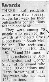
Newspaper Clipping from "The Mail", 25 May ,1993, Page 3. "Awards"Three local residents were awarded special badges last week for their outstanding contributions to the blood bank. They include Janet Beck of Croydon and George Silver of Ringwood who made 100 blood donations and Harry Browning of North Bayswater who has made 125 donations -
 Clunes Museum
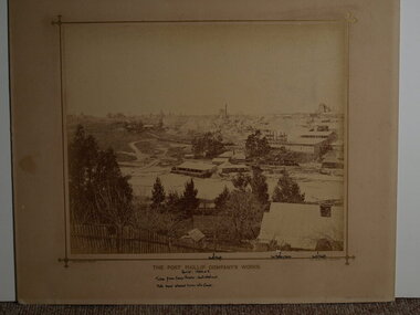
Photograph, BEAUCHAMP PHOTOGRAPHY, CIRCA 1884 - 1885
SEPIA PHOTOGRAPH OF PORT PHILLIP COMPANY'S WORKS.THE PORT PHILIP COMPANY'S WORK'S. HANDWRITTEN NOTES: PERIOD 1884 OR 5. TAKEN FROM CAMP PARADE: NOERTH WEST END NOTE SAND ALLOWED TO RUN INTO CREEK NORTH SHAFT, 2ND BATTERY HOUSE, SOUTH SHAFT. BEAUCHAMP PHOTO, 104 STURT STREET, BALLARATlocal history, mining, port phillip mine -
 Phillip Island and District Historical Society Inc.
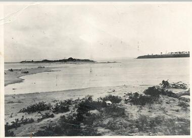
Photograph, 1890 - 1900
Sandy Island (no longer in existance) on the extremity of the sand spit on the north side of the "Nit" near Rhyll, Phillip Island. The original picture in the possession of Mr Les Findlay of Cowes was taken probably about 1890-1900.Black & White photograph of Sandy Island Rhyll - now gone.See below under History of Object.sandy island rhyll, arthur woodley -
 Greensborough Historical Society
Magazine, Banyule Banner. Jul-Aug 2019, 2019_07
The Banyule Banner is published bi-monthly by Banyule City Council to advertise upcoming events in the City of Banyule and to report on past events. This edition includes information on North East Link update, Banyule grants and budget.A record of events within the City of Banyule.20 pages (approx.), colour illustrations.banyule city council -
 Greensborough Historical Society
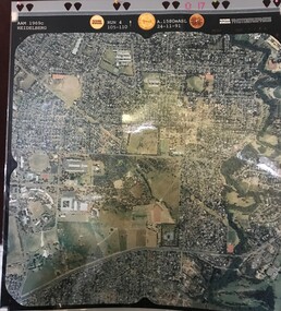
Aerial Photograph, AAM Photographics, Heidelberg AAM1969c 086, 24/11/1991
One of a series of four overlapping aerial photographs of the Heidelberg/Greensborough areas in 1991, covering Simpson Barracks, Macleod, Rosanna, Viewbank, Watsonia & Yallambie. North boundary Yallambie Road; West boundary Hurstbridge railway.Laminated colour aerial photographssimpson barracks, yallambie, watsonia, macleod, rosanna, viewbank -
 Greensborough Historical Society
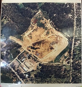
Aerial Photograph, AAM Photographics, Heidelberg AAM1969c 088, 24/11/1991
One of a series of overlapping aerial photographs of the Heidelberg/Greensborough area, covering Eaglemont, Heidelberg, Ivanhoe East & Viewbank. North boundary Hurstbridge railway, South boundary Ivanhoe East, East boundary Bulleen RoadLaminated colour aerial photographeaglemont, heidelberg, ivanhoe east, viewbank -
 Greensborough Historical Society
Map, Municipality of Heidelberg Plan No. 480, 17/10/1948
Map shows streets, buildings, river and major drainage easements in area covered by West boundary Sellars Street, North boundary Yando Street & South boundary Grimshaw Street. Adjoins Map No. 481 to East. Black & white map, features marked in green, gradients in red. Scale: 160 feet to 1 inchgreensborough -
 Greensborough Historical Society
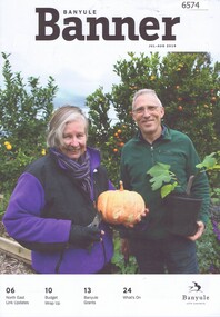
Magazine, Banyule Banner Nov-Dec 2019, 2019_11
The Banyule Banner is published bi-monthly by Banyule City Council to advertise upcoming events in the City of Banyule and to report on past events. This edition covers the Malahang Community Festival and developments with the North East Link project.A record of events within the City of Banyule.20 pages (approx.), colour illustrations. banyule banner, malahang festival, north east link -
![Photograph - Digital image, Edward Theodore Flintoff [and grave], 1870c](/media/collectors/4f729f5697f83e03086015b8/items/54434cd12162f10ea4a15f2b/item-media/544352ec2162f10ea4a19c55/item-fit-380x285.jpg) Greensborough Historical Society
Greensborough Historical SocietyPhotograph - Digital image, Edward Theodore Flintoff [and grave], 1870c
Photograph of a portrait of Edward Theodore Flintoff and his grave. The Flintoff family came to Greensborough circa 1841. They owned, farmed and leased land north of the present Civic Drive. Edward died on 14/06/1899. A pioneer Greensborough family.Digital copy of colour photographs.flintoff family, edward theodore flintoff -
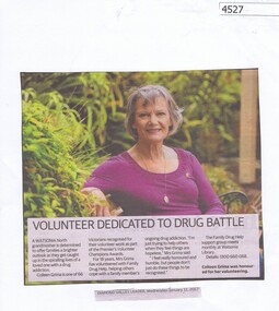 Greensborough Historical Society
Newspaper Clipping, Diamond Valley Leader, Volunteer Dedicated to Drug Battle, 11/01/2017
Colleen Grima is a Watsonia North grandmother who is determined to offer families a brighter outlook as they get caught up in the spiralling lives of a loved one with a drug addiction. She received a Premier's Volunteer Champions award.News article 1 page, black text, colour image.colleen grima, volunteering, drug addiction, premier's volunteer champions award -
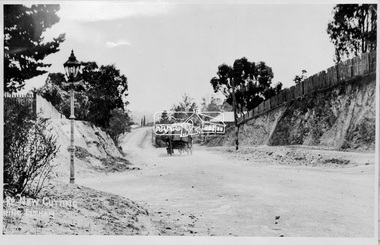 Eltham District Historical Society Inc
Negative - Photograph, Main Road, New Cutting Nearing Eltham, c.1908
Looking north from the corner of Bridge street The photo was possibly taken by John Henry Clark of Clark Bros Photographers who operated from 25 Thompson Street, Windsor near Prahan 1894-1914.This photo forms part of a collection of photographs gathered by the Shire of Eltham for their centenary project book,"Pioneers and Painters: 100 years of the Shire of Eltham" by Alan Marshall (1971). The collection of over 500 images is held in partnership between Eltham District Historical Society and Yarra Plenty Regional Library (Eltham Library) and is now formally known as the 'The Shire of Eltham Pioneers Photograph Collection.' It is significant in being the first community sourced collection representing the places and people of the Shire's first one hundred years.Digital image (x2) 4 x 5 inch B&W Negsepp, shire of eltham pioneers photograph collection, eltham, main road, gas lamp, street lamp, horse drawn vehicles, bakery, old bakery cottage, shillinglaw cottage, shillinglaw trees, clark bros. photo -
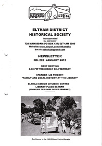 Eltham District Historical Society Inc
Newsletter, Newsletter, No. 202 January 2012
Contents: • Next meeting, guest speaker; Liz Pidgeon: Family and Local History at the Library • 2012 Program • February Meeting • J.B. North and the Meruka Estate • The Society Banner 1986 • Annual general Meeting • And Also The Shire of Eltham Historical Society was formed in October 1967. The first newsletter of the Society was issued May 1978 and has been published continuously ever since on a bi-monthly basis. With the cessation of the Shire of Eltham in late 1994, the Society's name was revised to Eltham District Historical Society and this name first appeared with issue No. 103, July 1995. The collection of the Society's newsletters provides a valuable resource on the history of the Society's activities, office bearers and committee members, guest speakers and subjects of historical interest pertinent to the former Shire of Eltham and the Eltham District.A4 photocopied newsletter distributed to membersnewsletter, eltham district historical society, shire of eltham historical society -
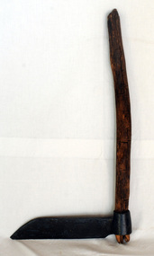 Orbost & District Historical Society
Paling knife, shingle froe, c. 1870s - 1930s
Likely used by the Jensen family who were early settlers in the Martin's Creek area, 35 miles north of Orbost, along the Bonang - Orbost Road in c. 1890. Peter Jensen came from Denmark. A flat iron blade, sharpened on the bottom and attached to a wooden handle. The blade has a pointed end.BRADES CO.shingle-making roofing-shingles house-construction -
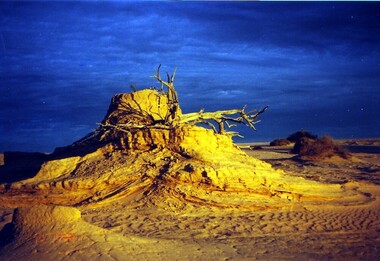 Victorian Interpretive Projects Inc.
Photograph - colour, Clare Gervasoni, Mungo at Dusk, 07/09/2008
Mungo National Park is a desert north of Mildura. It has numerous archaeological relics, and is the site of ancient Aboriginal burials known as Mungo Man and Mungo Woman. This photograph was taken during an expedition by Naga Tours in 2008.Colour photograph in digital format showing sand dunes and dramatic natural lighting at dusk at Mungo National Park. lake mungo, desert, archaeology, sand dune -
Tatura Irrigation & Wartime Camps Museum
Document, William McCartney's Houses & Stable
Material loaned for copying. Report prepared in 2001 on the remaining log house and stables on the property selected at Byrneside on the north west corner of Brewer Road and the Tatura Byrneside Road. Report contains copy of photographs and records. -
 Uniting Church Archives - Synod of Victoria
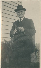
Photograph, Undated c.1930
William C. Tippett (1879 - 1940). Ordained in 1904. Stationed at: Lorquon, Daylesford, Foster, Cohuna, Omeo, Maldon, Geelong, Castlemaine. Chairman Castlemaine and Maryborough District. South Melbourne Mission, North Melbourne Mission.B & W full length photograph of the Rev W.C. Tippet, dressed in a 3 piece suit and homburg hat standing beside a weatherboard building.rev william c. tippett, methodist, minister -
 Hume City Civic Collection
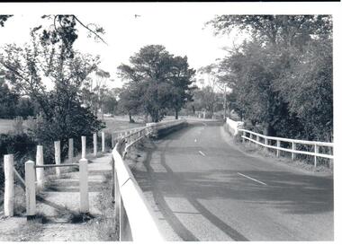
Photograph
In the 1970s the bluestone bridge over Jackson's Creek ceased to be used and a wider bridge was constructed to its north. The curved approach to the bridge was taken out of the road and the old approach area was redeveloped and is now Apex Park.A black and white photograph of the old stone bridge over Jackson's Creek in Macedon Street. A utility is in the distance approaching the bridge.macedon street, jackson's creek, bridges, transport, apex park, sunbury, jackson's creek bridge, george evans collection -
 Stawell Historical Society Inc
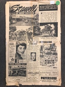
Archive - Newspaper Supplement, Stawell - An Argus Souvenir - 1955
Stawell Timber Industries Advertisement, North Western Woollen Mill Advertisement, Patterson's, T Barker Hardware, Coles, Sheffield's Cafe, Nalders Garage, Stawell Brick Co. Kingston's Motors, A.H. Welch Fashions.Six (6) Page Supplement April 7 1955tourism -
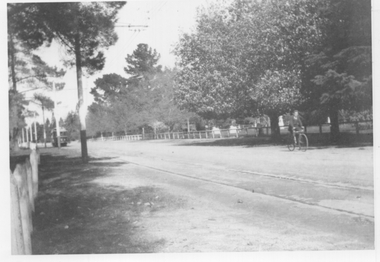 Ballarat Tramway Museum
Photograph - Wendouree Parade - Gardens area, mid 1930s
Black and white photograph of Wendouree Parade looking south. There is an SEC tram in the far distance. A young lad on a bicycle is north bound. Note the fence type on either side of the roadways. Photo possibly mid 1930s.Yields information about Wendouree Parade possibly mid 1930s.Black and white photograph on plain paper.trams, tramways, wendouree parade, botanical gardens -
 Bayside Gallery - Bayside City Council Art & Heritage Collection
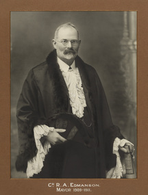
Photograph - gelatin silver photograph, Councillor R.A. Edmanson, Mayor of Brighton 1909-11, c.1911
Robert Arthur Edmanson (c.1858-1948) was elected as a councillor of the North Ward in Brighton in 1904, becoming Mayor in August 1909 and re-elected in September 1910. In 1912 he stood for election at Prahran Council.councillor, local government, municipality, mayor, portrait, mayoral robes, mayor of brighton, robert arthur edmanson, r.a. edmanson, north ward, brighton -
 Melbourne Tram Museum
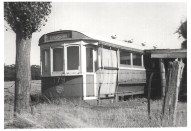
Photograph - Scrapped Melbourne T class trams 179 and 182, Bob Lilburn, 1965 & 1970
Two photos of scrapped former Melbourne T class trams 1 - T179, photographed at Dean (north of Ballarat), 14/3/1965 2 - T182, at Wangaratta on wooden support stands, 9/1/1970Yields information about two scrapped T class trams.Set of two black and white photographs of scrapped former Melbourne T class tramsDetails written on the rear with information labels along with photographer's R Lilburn name.tramways, t class, tram 179, tram 182, scrapped trams, melbourne -
 Ballarat Tramway Museum
Negative - Geelong tram at Balliang St loop in Moorabool St, Laurie Gallop, early 1956
Photo shows a Geelong tram to North in Moorabool St at the Balliang St / Forser St loop in Moorabool St. Has the rail over bridge in the far distance. See also item 8298 for the approaching photo.Yields information about the Geelong operations toward the closure of the tram system.Black and white Negative - 120 sizetramways, geelong, belmont, moorabool st