Showing 13176 items matching "2019-08-30"
-
 Bendigo Historical Society Inc.
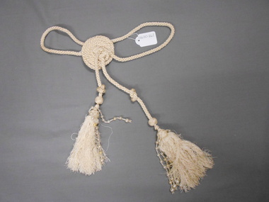
Clothing - DECORATIVE CORDING AND PEARL TRIMMED TASSEL, 1920's - 30's,maybe1800's
Cream silk, cord, wound into a 7cm diameter disk, with loops and decorative pearl trimmed tassel. Matching 11400.843, there is no evidence on the evening cape that it was at one time, attached. This item may be a decorative item that was worn over the wrist, and added interest to the wearer of the cape. A ''turk's head'' woven ball'', 1.5cm diameter, and tassel head, add to this decorative item.costume accessories, female, decorative cord and pearl trimmed tassel -
 Bendigo Historical Society Inc.
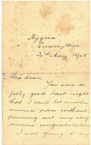
Document - HAMILTON COLLECTION: PERSONAL LETTER, 30 May1905
Document. Personal letter from ''Hag'' ''Hygeia'' Quarry Hill, 30th May 1905 to Alex Hamilton.Letter congratulates Alex on his performance the previous night.performing arts, elocution, personal letter -
 Bendigo Historical Society Inc.
Map - JACK FLYNN COLLECTION: VILLAGE OF BETLEY, 30/06/1874
Map: Village of Betley, on the Bet Bet Creek, Parish of Dunolly. Parish plan.Photo Lithographed at the Department of Lands and Survey Melbourne by J. Noone 30.6.74map, gladstone, village, betley, bet bet creek, dunolly -
 Bendigo Historical Society Inc.
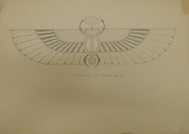
Drawing - NORMAN PENROSE COLLECTION: BORDER DESIGNS, 30/6/26 on one drawing
Artwork. Norman Penrose collection: 6 various designs suitable for borders. Gothic Flat Carving. Greek Vase Decoration (2)drawing, pencil, norman penrose collection, artwork, gothic flat carving, greek vase decoration -
 Bendigo Historical Society Inc.
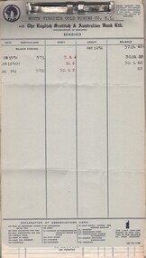
Document - MCCOLL, RANKIN AND STANISTREET COLLECTION: NORTH VIRGINIA GMC N L - PASS BOOK, 30/6/1944 - 14/5/1956
Document. Solid card (speckled tan) red spine. Pass book for the North Virginia GMC N L. Details of financial transactions at The English Scottish & Australian Bank.McColl, Rankin & Stanistreetorganization, business, north virginia gmc n l, mccoll, rankin & stanistreet, north virginia gmc n l, gold mining, pass book -
 Bendigo Historical Society Inc.
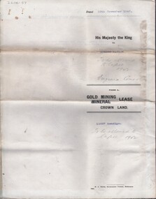
Document - MCCOLL, RANKIN AND STANISTREET COLLECTION: NORTH VIRGINIA GMC N L - TITLE DEED/LEASE, 30/11/1940
Document. Coarse cream coloured paper typed. Corrections and additions. Assistant Registrar of Titles. Made out to Robert Watson of Eaglehawk. Has map of lease in the back.McColl, Rankin & Stanistreetorganization, business, north virginia gmc n l, mccoll, rankin & stanistreet, north virginia gmc n l, r watson, gold mining, title deed/lease -
 Bendigo Historical Society Inc.
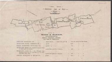
Document - KELLY AND ALLSOP COLLECTION: HUSTLERS LINE OF REEF MAP, 30/07/1891
Document. KELLY & ALLSOP COLLECTION. Map of the Hustlers Line of Reef, Bendigo (South portion). Issued by Wood & McNair, Sharebrokers, Beehive Chambers, Bendigo and High St., Eaglehawk. Mines shown on map are Fortuna Hustler's Co., Hustler's Royal Reserve No.2, Great Extended Hustlers Co., Hustlers Reef Co., Hustler's Reef No.1 Co., United Hustler's & Redan Co. Number of shares is listed against each of these mines.Wood & McNairbusiness, stockbroker, kelly & allsop, kelly & allsop collection, hustlers line of reef map, wood & mcnair. -
 Bendigo Historical Society Inc.
Map - BOROUGH OF EAGLEHAWK SHEET 1A, 30/11/1931
Map: Borough of Eaglehawk, Parish of Nerring. Parish plan ( number 186 in Map Cupboard 1)map, bendigo, parish plan, borough of eaglehawk, parish of nerring -
Bendigo Historical Society Inc.
Map - BOROUGH OF EAGLEHAWK, 30/11/1931
Map: Borough of Eagle hawk, Parish of Nerring. Parish plan with coloured areas ( number 185 in Map Cupboard 1)map, bendigo, parish plan, borough of eaglehawk, parish of nerring -
 Bendigo Historical Society Inc.
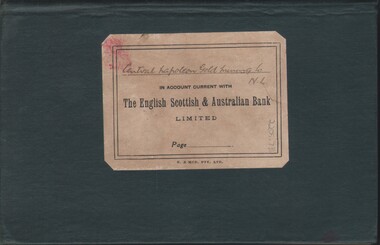
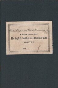
Document - MCCOLL, RANKIN AND STANISTREET COLLECTION: CENTRAL NAPOLEON GOLD MINING CO. N.L, 7 Jan 1940 - 30 May 1944
Document: Bank account book for 'Central Napoleon Gold Mining Co N.L.', with 'The English Scottish & Austrlian Bank Ltd', Green Cloth cover lable glued on front, not quite half full, Markings: Handwriting: 'Central Napoleon Gold Mining Co N.L', Print: 'In account current with The English Scottish & Australian Bank Ltd'.organization, business, industrial - mining, mccoll rankin & stanistreet, mining, gold mining, central napoleon -
 Bendigo Historical Society Inc.
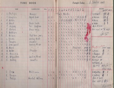
Document - MCCOLL, RANKIN AND STANISTREET COLLECTION: NELL GWYNNE REEF N/L - WAGES BOOK, 6/10/1948 - 30/11/1949
Document. Light brown book with dark brown binding. Only 1/3 of the book has been used.McColl, Rankin & Stanistreetorganization, business, nell gwynne reef mine, mccoll, rankin & stanistreet, nell gwynne reef n/l, gold mining, wages book -
 Bendigo Historical Society Inc.
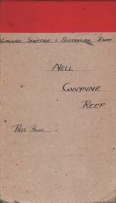
Document - MCCOLL, RANKIN AND STANISTREET COLLECTION: NELL GWYNNE REEF N/L - ES & A PASS BOOK, 30/6/1944 - 7/2/1962
Document. English, Scottish & Australlian Bank pass book containing debits & credits. Light greyish brown cardboard cover with red binding.McColl, Rankin & Stanistreetorganization, business, nell gwynne reef mine, mccoll, rankin & stanistreet, nell gwynne reef, gold mining, pass book -
 Bendigo Historical Society Inc.
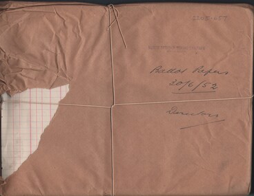
Document - MCCOLL, RANKIN AND STANISTREET COLLECTION: NORTH DEBORAH MINING CO. N/L - BALLOT PAPERS, 30/6/52
Document. Ballot papers wrapped in brown paper and tied up with string.McColl, Rankin & Stanistreetorganization, business, north deborah mine, mccoll, rankin & stanistreet, north deborah mining co. n/l, gold mining, ballot papers -
 Bendigo Historical Society Inc.
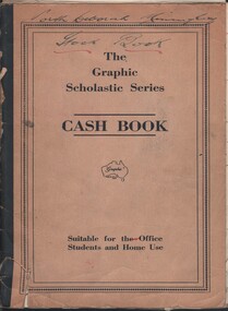
Document - MCCOLL, RANKIN AND STANISTREET COLLECTION: NORTH DEBORAH GMC N/L - STOCK BOOK, 30/11/1942 - 31/5/1948
Document. Brown cash book with black binding. Cash book printed on the front. Contains 11 loose pages.McColl, Rankin & Stanistreetorganization, business, north deborah mine, mccoll, rankin & stanistreet, north deborah gmc, gold mining, stock book -
 Bendigo Historical Society Inc.
Document - MCCOLL, RANKIN AND STANISTREET COLLECTION: NORTH VIRGINIA GMC N L - BANK BOOKS, 12 Dec 1933 - 30 Jun 1944
Document. 5 blue/grey cloth covered bank books. White label on the front 'North Virginia Gold Mining Co. N. L. in account current with The English Scottish & Australian Bank Limited.'McColl, Rankin & Stanistreetorganization, business, north virginia gmc n l, mccoll, rankin & stanistreet, north virginia gmc n l, the english, scottish & australian bank limited, gold mining, bank books -
 Bendigo Historical Society Inc.
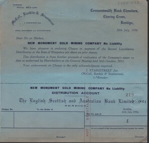
Document - MCCOLL, RANKIN AND STANISTREET COLLECTION: NEW MONUMENT GMC N/L - BUNDLE OF CHEQUES, 30 July 1956
Document. Bundle of blue cheques of New Monument Gold Mining Company Distribution Account. (Extras)Commonwealth Bank Chambers Charing Cross Bendigo McColl, Rankin & Stanistreet - Legal Managers and Accountants.McColl, Rankin & Stanistreetorganization, business, new monument gmc n/l, mccoll, rankin & stanistreet, new monument gmc n/l, gold mining, cheques -
 Bendigo Historical Society Inc.
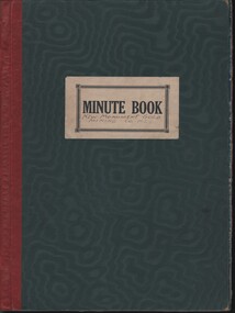
Document - MCCOLL, RANKIN AND STANISTREET COLLECTION: NEW MONUMENT GMC N/L - MINUTE BOOK, 18/8/1939 - 30/9/1960
Document. Green book with wavy pattern and red binding. Coloured feathery pattern on page edges.McColl, Rankin & Stanistreetcottage, miners, mccoll, rankin & stanistreet, new monument gmc, gold mining, minute book -
 Victorian Interpretive Projects Inc.
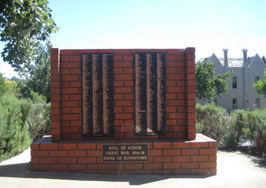
Photograph - Digital, Clare Gervasoni, Buninyong Avenue of Honour, 30/12/2011
buninyong avenue of honour, buninyong, world war one, world war -
 Victorian Interpretive Projects Inc.
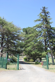
Photograph - Colour, Clare Gervasoni, Buninyong Cemetery, 2014, 30/12/2011
Buninyong was Victoria's first inland town,Seven colour photographs showing scenes in the Buninyong Cemetery.buninyong, cemetery, grave -
 Victorian Interpretive Projects Inc.
Photograph - Colour, Clare Gervasoni, Ballarat towards Sturt Street from the Ballarat Trades Hall, 2015, 30/07/2015
Rooflines and buildings from the top of the Ballarat Trades Hall in Camp Street Ballarat.ballarat trades hall, camp street, sturt street, ballarat, aerial -
Moorabbin Air Museum
Document (item) - Vickers-Armstrong Design for a Commercial Hovercraft, The Engineering Design of a Commercial Hovercraft by S. R. Hughes, 30/7/1962
-
 National Vietnam Veterans Museum (NVVM)
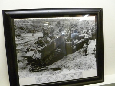
Photograph - Photograph, framed, APC, 30/09/1970 12:00:00 AM
Black and white photograph of an APC and two Centurion tanks. APC is damaged and resting on the rear of a tank after being blown up by a 180lb shell, set as a landmine. Infantry and cavalry personnel climb all over APC and tanks assessing damage. Photo is in a black frame.Photograph description of scene as accompanment of photodenis gibbons, armoured personnel carrier, centurion tank, "nympho", operation massey-harris -
 St Kilda Historical Society
Photograph - Photo map, 30/01/1960
One of a series of photo-maps produced for the Department of Crown Lands and Survey (1857-1983). For correlation with a current map, and access to other historical photo maps of Victoria, see the Historic Photo-Maps Index published by the Department of Environment, Land, Water and Planning at https://services.land.vic.gov.au/DELWPmaps/historical-photomaps/Black and white aerial photographVic 1093-62 Melbourne & Metropolitan Project Run 21 30.1.60 Lens 10" 8.200middle park, albert park, catani gardens, st kilda west, 1960 -
 St Kilda Historical Society
Photograph - Photo map, 30/01/1960
One of a series of photo-maps produced for the Department of Crown Lands and Survey (1857-1983). For correlation with a current map, and access to other historical photo maps of Victoria, see the Historic Photo-Maps Index published by the Department of Environment, Land, Water and Planning at https://services.land.vic.gov.au/DELWPmaps/historical-photomaps/Black and white aerial photographVic 1093-60 Melbourne & Metropolitan Project Run 21 30.1.60 Lens 10" 8.200st kilda, albert park, prahran, windsor, south yarra, 1960 -
 St Kilda Historical Society
Photograph - Photo map, 30/01/1960
One of a series of photo-maps produced for the Department of Crown Lands and Survey (1857-1983). For correlation with a current map, and access to other historical photo maps of Victoria, see the Historic Photo-Maps Index published by the Department of Environment, Land, Water and Planning at https://services.land.vic.gov.au/DELWPmaps/historical-photomaps/Black and white aerial photographVic 1092-36 Melbourne & Metropolitan Project Run 22 30.1.60 Lens 10" 8.200st kilda, st kilda pier, st kilda beach, catani gardens, 1960 -
 St Kilda Historical Society
Photograph - Photo map, 30/01/1960
One of a series of photo-maps produced for the Department of Crown Lands and Survey (1857-1983). For correlation with a current map, and access to other historical photo maps of Victoria, see the Historic Photo-Maps Index published by the Department of Environment, Land, Water and Planning at https://services.land.vic.gov.au/DELWPmaps/historical-photomaps/Black and white aerial photographVic 1092-38 Melbourne & Metropolitan Project Run 22 30.1.60 Lens 10" 8.200st kilda, st kilda beach, st kilda pier, catani gardens, 1960, st kilda botanical gardens, peanut farm -
 St Kilda Historical Society
Photograph - Photo map, 30/01/1960
One of a series of photo-maps produced for the Department of Crown Lands and Survey (1857-1983). For correlation with a current map, and access to other historical photo maps of Victoria, see the Historic Photo-Maps Index published by the Department of Environment, Land, Water and Planning at https://services.land.vic.gov.au/DELWPmaps/historical-photomaps/Black and white aerial photographVic 1092-40 Melbourne & Metropolitan Project Run 22 30.1.60 Lens 10" 8.200st kilda east, balaclava, ripponlea, st kilda cemetery, 1960 -
 St Kilda Historical Society
Photograph - Photo map, 30/01/1960
One of a series of photo-maps produced for the Department of Crown Lands and Survey (1857-1983). For correlation with a current map, and access to other historical photo maps of Victoria, see the Historic Photo-Maps Index published by the Department of Environment, Land, Water and Planning at https://services.land.vic.gov.au/DELWPmaps/historical-photomaps/Black and white aerial photographVic 1092-42 Melbourne & Metropolitan Project Run 22 30.1.60 Lens 10" 8.200malvern, caulfield, caulfield park, 1960 -
 St Kilda Historical Society
Photograph - Photo map, 30/01/1960
One of a series of photo-maps produced for the Department of Crown Lands and Survey (1857-1983). For correlation with a current map, and access to other historical photo maps of Victoria, see the Historic Photo-Maps Index published by the Department of Environment, Land, Water and Planning at https://services.land.vic.gov.au/DELWPmaps/historical-photomaps/Black and white aerial photographVic 1091-112 Melbourne & Metropolitan Project Run 23East 30.1.1960 Lens 10" 8.200elwood, point ormond, elwood park, elwood canal, 1960 -
 St Kilda Historical Society
Photograph - Photo map, 30/01/1960
One of a series of photo-maps produced for the Department of Crown Lands and Survey (1857-1983). For correlation with a current map, and access to other historical photo maps of Victoria, see the Historic Photo-Maps Index published by the Department of Environment, Land, Water and Planning at https://services.land.vic.gov.au/DELWPmaps/historical-photomaps/Black and white aerial photographVic 1091-110 Melbourne & Metropolitan Project Run 23East 30.1.60 Lens 10" 8.200elwood, elsternwick, elsternwick park, ripponlea, st kilda east, caulfield, balaclava, 1960