Showing 25185 items
matching north
-
 Kew Historical Society Inc
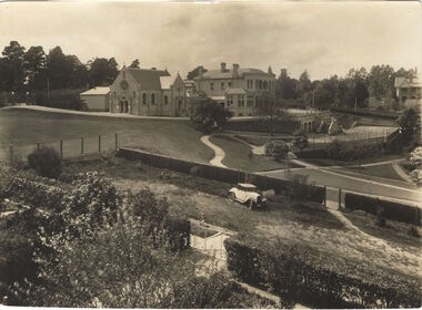
Photograph, Burke Hall, Xavier Preparatory School, circa 1930, c. 1930
This work forms part of the collection assembled by the historian Dorothy Rogers, that was donated to the Kew Historical Society by her son John Rogers in 2015. The manuscripts, photographs, maps, and documents were sourced by her from both family and local collections or produced as references for her print publications. Many were directly used by Rogers in writing ‘Lovely Old Homes of Kew’ (1961) and 'A History of Kew' (1973), or the numerous articles on local history that she produced for suburban newspapers. Most of the photographs in the collection include detailed annotations in her hand. The Rogers Collection provides a comprehensive insight into the working habits of a historian in the 1960s and 1970s. Together it forms the largest privately-donated collection within the archives of the Kew Historical Society.A panoramic photograph of the grounds of Xavier Preparatory School taken from the vicinity of Studley House, looking north east towards Burke Hall (originally Studley Hall). The foreground to the left of the chapel is an oval known as the Chapel Oval (later known as Studley Oval). The ground to the right front is now known as the Jack Gervasoni oval. The house to the far right (part view) is "Campion".Burke Hall (Xavier Preparatory School) formerly Waverley. Built by Charles Griffiths ca. 1869 (Panoramic view from East [sic]) burke hall, studley hall, xavier preparatory school, kew, studley park, dorothy rogers, chapel oval, jack gervasoni oval, burke hall chapel, studley oval, charles griffiths -
 Queen Victoria Women's Centre
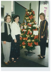
Photograph, December 1997
Colour photograph. Christmas 1997 Networking and Shilling Fund Breakfast. Three women are standing in the ground floor north foyer of the QVWC building. They stand around a Christmas tree adorned with multiple and various dollar notes. Left to right: Glenys Sharma (first General Manager), Kerri Ward (Marketing from Francis Tobin & Associates) and Janet England (first Chair of the Trust). Was a standard size but has been cut. christmas decorations, christmas, fundraising events -
 Surrey Hills Historical Society Collection
Map, Contour map of Surrey Hills showing potential sites for the Telecom Tower
The PMG / Telecom / Telstra tower was built in 1961-1963 as a relay station to support television and radio links between city and regional broadcasting stations. The tower itself was 45 m in height with a 2 storey building for equipment and staff surrounded by garden. From the beginning it was opposed by local residents. The location is said to be the second highest site in Melbourne, sometimes described as Delaney's Hill.Two A3 photocopied sheets of a map showing part of Surrey Hills, roughly between Windsor Crescent and Belmont Street (north / south) and Standard Avenue and Balmoral Crescent (east / west). The map shows contour lines and house sites, 16 of which are numbered. One sheet has been inscribed in top RH corner with notes regarding the significance of the numbers."Contour map of potential sites / for the telecommunications tower which / was eventually sited at 2. / Jock Campbell OBE was our neighbour / at 4 Theodore St when we moved into / the area in 1984. He was responsible in his / job at the PMG in deciding on the /site of the tower - Note site 5 was / behind his (& our) house. / Jack ended his career as Deputy Director / of the PMG. He sat on international committees / after WW2 to decide the split of the electronic / spectrum for radio, TV etc. / His group developed a "mobile phone" using / fixed towers but the phone was a truck full of gear."contour map, telecom tower, maps, jock campbell, john duncan campbell -
 Bendigo Historical Society Inc.
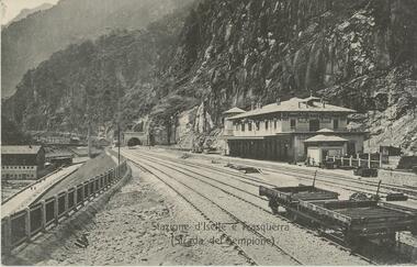
Postcard - ROY AND DORIS KELLY COLLECTION: STAZIONE D'ISELLE E TRASQUERRA (STRADA DEL SEMPIONE), CARTE POSTALE, 1900-1920
Postcard, B&W photo of the railway station serving the villages of Iselle and Trasquerra in the Piedmont region of north west Italy. It was opened in 1906. The rail tracks lead to the entrance of the Simplon Tunnel in the distance. An empty flat tray carriage sits on the tracks (lower right). Part of the the Simplon road (Strada del Sempione) is shown at lower left. This road connects Italy to Switzerland.postcard, photograph, postcard, iselle, trasquerra, italy, station, simplon tunnel. -
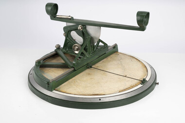
 Department of Energy, Environment and Climate Action
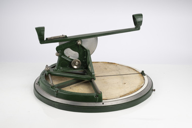
Fire Finder
Victoria once had well over one hundred fire lookouts and firetowers. Fire lookouts, or observation posts, were often just a clearing on a hill or a vantage point, whereas firetowers were definite structures. Many were established by the Forests Commission Victoria (FCV) in the 1920s, but the network was expanded rapidly in response to recommendations of the Stretton Royal Commission after the 1939 Black Friday bushfires. When a fire or smoke was spotted from the tower a bearing was taken with the alidade and radioed or telephoned into the district office. It was then cross referenced with bearings from other towers on a large wall map to give a "fix" on the fire location. Alidades and telescopes were used in the post war period but were replaced with a much simpler map table and reference string suspended from the centre of the tower cabin. This "Fire Finder" was used in Canadian fire towers to identify the location of wildfires. The unique design was first developed by the British Columbia Forest Service (BCFS) in the early 1950s. Close examination of the map indicates that this particular Fire Finder may have been once used at Bluejoint Mountain lookout in Granby Provincial Park. This Fire Finder was a gift to Barry (Rocky) Marsden from the British Columbia Forest Service in the late 1980s in recognition of the close relationships that had been forged with the staff at the Altona Workshops over many decades. Fire Finders were originally painted black but this one was repainted green after it arrived at Altona. The BC Forest Service had a large facility where they manufactured Fire Finders and many other items of equipment, but in the 1980s it was shut down. Heavy cast iron circular object with a paper topographic map mounted on it. The metal dial and ruler works similar to a compass. The sight tube is used to determine the bearing and elevation of the fire on the map. This Fire Finder also sometimes known as an Alidade. Its a different design from the Osborne Fire Finder widely used in North American fire lookouts from the 1920s. British Columbia Forest Service. Model 62A. Serial Number 6308.bushfire -
 Department of Energy, Environment and Climate Action
Fire Finder
Victoria once had well over one hundred fire lookouts and firetowers. Fire lookouts, or observation posts, were often just a clearing on a hill or a vantage point, whereas firetowers were definite structures. Many were established by the Forests Commission Victoria (FCV) in the 1920s, but the network was expanded rapidly in response to recommendations of the Stretton Royal Commission after the 1939 Black Friday bushfires. When a fire or smoke was spotted from the tower a bearing was taken with the alidade and radioed or telephoned into the district office. It was then cross referenced with bearings from other towers on a large wall map to give a "fix" on the fire location. Alidades and telescopes were used in the post war period but were replaced with a much simpler map table and reference string suspended from the centre of the tower cabin. This "Fire Finder" was used in Canadian fire towers to identify the location of wildfires. The unique design was first developed by the British Columbia Forest Service (BCFS) in the early 1950s. Close examination of the map indicates that this particular Fire Finder may have been once used at Bluejoint Mountain lookout in Granby Provincial Park. This Fire Finder was a gift to Barry (Rocky) Marsden from the British Columbia Forest Service in the late 1980s in recognition of the close relationships that had been forged with the staff at the Altona Workshops over many decades. Fire Finders were originally painted black but this one was repainted green after it arrived at Altona. The BC Forest Service had a large facility where they manufactured Fire Finders and many other items of equipment, but in the 1980s it was shut down. Heavy cast iron circular object with a paper topographic map mounted on it. The metal dial and ruler works similar to a compass. The sight tube is used to determine the bearing and elevation of the fire on the map. This Fire Finder also sometimes known as an Alidade. Its a different design from the Osborne Fire Finder widely used in North American fire lookouts from the 1920s. British Columbia Forest Service. Model 62A. Serial Number 6308.bushfire -
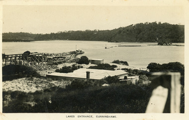 Lakes Entrance Historical Society
Postcard - New Works, Bulmer H D, 1910c
Also second copy same sizeBlack and white postcard showing view of Works buildings and north end of eastern pier. Cunninghame Arm and tip of Bullock Island and groyne work on right. Reeves channel and tip of Rigby Island on left. Mt Barkly and Kalimna Hills in background. Photo taken from top of dune. Roof of Carstairs boarding house centre foreground. Lakes Entrance VictoriaLakes Entrance, Cunninghamewaterways, settlement, historic buildings -
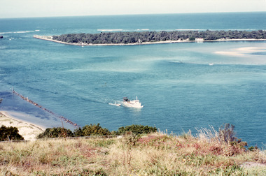 Lakes Entrance Historical Society
Photograph - The Entrance, Fraser, Ian, 1990c
Colour photograph of the lake. It shows a fishing boat with scallop dredge moving up the lake opposite the artificial entrance, grassy edge of Jemmy's Point in foreground above highway guard fence, rock groyne at entry to North Arm, sandy shallows at entry to Hopetoun Channel, scrub covered hummocks of south shore and Bass Strait in distance. Lakes Entrance Victoriaislands, waterways, topography -
Clunes Museum
Negative - NEGATIVE PLATES
Negatives taken and owned by Carl Weickhardt, grandson of Johannes, Son of Jacob (Tank Maker)10 Glass Negative Plates in a box with a note "our grandparents D & K Patience" .1 Weickhardt Tanks .2 Fire Brigade .3 David and Kate Patience .4 Ballarat Bakery (Clunes) .5 Montage of F Weickhardt .6 Tank on a lorry .7 Tank .8 Clunes North School .9 Aeroplane landing .10 Aeroplane landingOn box; Kodak, Abbotsford, Melbournenegatives, patience, tanks, kodak -
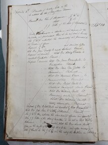
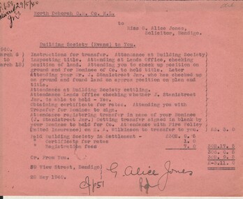 Bendigo Historical Society Inc.
Document - MISS G ALICE JONES COLLECTION: ACCOUNT
North Deborah G. M. Co. N. L. to Miss G. Alice Jones. Pink paper dated March 6 to 18 1940 and 28 May 1940. Re Building Society (Evans) to You. Account details work and expenses involved in the transfer of land. "R688 delivered 29/5/40" written in the top left corner. Cost £3.11.0.miss g alice jones - solicitor - account, north deborah g m co n l, building society (evans), mr j stanistreet jnr, united insurance, h a wilkinson -
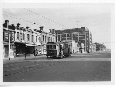
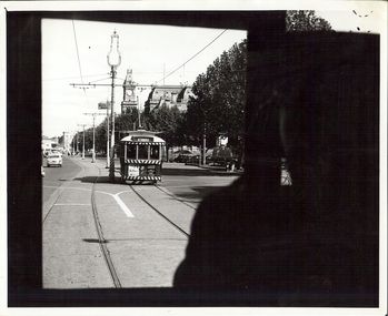 Bendigo Historical Society Inc.
Photograph - BASIL MILLER COLLECTION: NUMBER 7 TRAM
Black and white photograph taken while on board tram, of another tram heading up Pall Mall, destined for North Bendigo line. Post Office, Law Courts and City Family Hotel are all visible ion the background. Stamped in black on the back of photo: Photograph by Claver P. Carroll 79 Eaglehawk Road Eaglehawk. No. TR25. There are two copies of this photo.Claver P. Carrollbasil miller, bendigo trams -
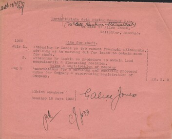 Bendigo Historical Society Inc.
Document - MISS G ALICE JONES COLLECTION: ACCOUNT
North Virginia Gold Mining Company N. L. (McColl Rankin & Stanistreet) to Miss G. Alice Jones. Pink paper dated July 1, 3 and Aug 1, 1933. Costs involved in procedure to obtain lease of land for shaft and perusing and checking proposed rules for company & supervising registration of company. Cost £2.2.0. Deld 19/9/33 GAJ.miss g alice jones - solicitor - account, north virginia gold mining company n l, mccoll rankin & stanistreet, mr leeds, mr rankin -
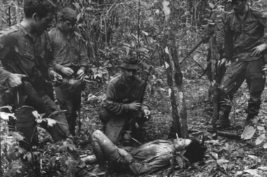 National Vietnam Veterans Museum (NVVM)
Photograph, Gibbons, Denis, Wounded VC Soldier
Denis Gibbons (1937 – 2011) Trained with the Australian Army, before travelling to Vietnam in January 1966, Denis stayed with the 1st Australian Task Force in Nui Dat working as a photographer. For almost five years Gibbons toured with nine Australian infantry battalions, posting compelling war images from within many combat zones before being flown out in late November 1970 after sustaining injuries. The images held within the National Vietnam Veterans Museum make up the Gibbons Collection. A black and white photograph of Diggers from 11 Platoon, D Copany, 6 RAR/NZ (ANZAC) on Operation Lavarack, North East of the Australian Task force Base at Nui Dat, Cpl R Bunting, Medic Pte T Spriggs, 2Lt A Valentine, Cpl D Severn and Cpl G Robinsin watch as the medic prepares to treat the wounded VCphotograph, 11 platoon, d coy, 6 rar/nz, operation lavarack, australian task force, nui dat, pte t spriggs, 2lt a valentine, cpl d severn, cpl g robinson, cpl r bunting, gibbons collection catalogue, medic, diggers, 6 rar/nz (anzac), wounded viet cong soldier, denis gibbons -
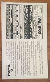 Melbourne Tram Museum
Poster, The Met, "Speed Hogs", May. 1984
Advertising Poster for use in Tramcars printed on heavy cardboard - titled "Speed Hogs" about the opening of the final section of the Underground loop or City Loop - has a cartoon by "Jeff" - notes the connection of the north western lines - 1 May 1984 (PTV Website loop history accessed 7-2-2016) Has The Met logo in the bottom right hand corner.trams, tramways, the met, city loop, melbourne -
 Melbourne Tram Museum
Ephemera - Timetable, Melbourne & Metropolitan Tramways Board (MMTB), Three mixed timetables, Dec. 1968
Timetable - printed or photocopied on foolscap paper for weekdays, Saturdays and Sunday and running times. Has various symbols for depot run in etc. In a style for public use. .1 - North Richmond - Prahran - St Kilda Beach - Feb. 1969 - two copies .2 - Wattle Park - City - Jan. 1969 - two copies .3 - Burwood - Spencer St - Dec. 1968trams, tramways, mmtb, timetables, buses, trams, north richmond, prahran, st kilda, wattle park, burwood -
 Melbourne Tram Museum
Photograph - Black & White Photograph/s, c1905
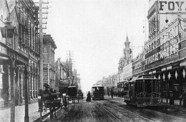
Photographs, Black and White, Photo of Elizabeth St, to the north of Collins St looking south towards Flinders St and Flinders St Station. Has a bogie cable trailer in the view, along with other cable trams, horse drawn vehicles and many pedestrians. In the background is Royal Bank, Craig Williamson, Sargent's Cafe and R. White on the corner. The photograph has a serrated edge.In ink on the rear: Keith Kings stamp and number S-A-449 "Melbourne - Elizabeth St, looking south over Collins St. About 1900. Note Bogie Cable Trailer"trams, tramways, elizabeth st, collins st, cable trams -
 Melbourne Tram Museum
Document - Tender Document, Melbourne & Metropolitan Tramways Board (MMTB), Tramway Board (MMTB), "Contract No. 92 Purchase and removal of WB Cottage Royal Park - Tender form", Nov. 1917
Tender document - single foolscap sheet - "Contract No. 92 Purchase and removal of WB Cottage Royal Park - Tender form". closing 7/4/1920. Notes cottage as four room, recently vacated by the Caretaker. No drawings provided. 2 copies held. .1 - single foolscap sheet for the purchase and removal of No. 41 Abbotsford St North Melbourne. Dated 1917.Handwritten notation in top right hand corner - "Board File"trams, tramways, tenders, contracts, mmtb, royal park, horse trams, zoo tram, north melbourne, abbotsford st -
 Melbourne Tram Museum
Postcard, Margiesphotos ,McKenzie Photography, "Richmond", c1990
Postcard - of W7 1015 in Church St Richmond at Swan St by McKenzie Photography titled "Richmond" and "Australia" Tram has the destination of North Richmond, route 78. Keith notes that he purchased the card 15/12/2011, the paintwork is in poor condition, its location and extensive notes checking the location. Has a copyright note by Margie photos and telephone number.trams, tramways, church st, swan st, richmond, north richmond, route 78, postcards, tram 1015 -
 Melbourne Tram Museum
Photograph - Black & White Photograph/s, Tramway Museum Society of Victoria (TMSV), c1975
Black & White Photograph of a postcard made by the TMSV Sales of Smith St Collingwood looking north with a cable car (Spencer St) and another in the view along with horse drawn vehicles. Has the Foy & Gibson Smith St buildings in the view. It would appear the cable car ironwork has been enhanced. Two copies held - the second copy is a slightly wider view.trams, tramways, smith st, cable trams -
 Bendigo Historical Society Inc.
Document - NORTH DEBORAH GOLD MINING CO N. L. - CONTRACTS FORTNIGHT ENDED 6/8/52
Two handwritten pages and typed copies of same, listing Contracts for the fortnight ended 6/8/52. Mentioned are the tons of ore, number of shifts, number of feet and expenses. Contractors are: Epworth, Clark, Monro, Nixon, Lewis, Harris, Turner, Panozzo, Bau and Greenwood. Copied from North Deborah Wages Sheet 12/11/70. Albert Richardson Collection. document, gold, north deborah gold mining co n. l., north deborah gold mining co n. l., contracts fortnight ended 6/8/52 north deborah gold mining co n. l., epworth, clark, monro, nixon, lewis, harris, turner, panozzo, bau, greenwood -
 Bendigo Historical Society Inc.
Document - PADDY'S GULLY LINE - VIRGINIA CONSOLS MINE
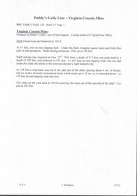
Handwritten page of notes on the Virginia Consols Mine on Paddy's Gully Line of Reef. Notes mention shaft being cleaned out and timbered to 100 ft. Also depth of work, timbering and geological features. Also a small piece of paper with:- Virginia Consols Mine 2 miles North of E'hawk Town Hall. Paddy's Gully Line. Notes prepared by Albert Richardson.document, gold, paddy's gully line, paddy's gully line, virginia consols mine, e'hawk town hall -
 Ringwood and District Historical Society
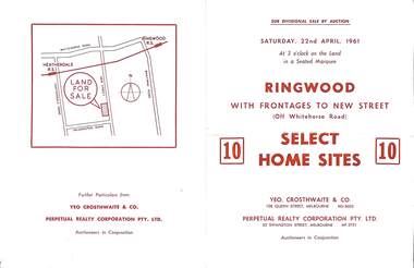
Flyer, Auction sale brochure advertising home sites with frontages to New Street, Ringwood, Victoria - 1961
Advertisement for Sub-divisional sale by auction on Saturday, 22nd April, 1961, with terms of sale of 10 home sites with frontages to New Street, Ringwood, Victoria.Location map showing land for sale on New Street, Ringwood, north of Palmerston Road. Auctioneers in conjunction - Yeo, Crosthwaite & Co., 108 Queen Street Melbourne (Telephone) MU 8605, and Perpetual Realty Corporation Pty. Ltd., 62 Swanston Street, Melbourne (Telephone) MF 3721. -
 City of Kingston
Book - Minute book
The Sons of Temperance was founded in New York in 1842 and brought to New South Wales by the Baptist minister, Dr William Hobbs, a short time later. Division, or local branches, grew quickly so that in October 1864, a provisional Grand Division was formed with a commitment to spread the word on temperance throughout the country, and the advantages gained by joining a temperance benefit society. It was reported that by 1869, in New South Wales, there was a National Division, two Grand Divisions, and one hundred and seven Divisions, with a total membership of 5970. While a distinct part of the temperance movement, the Sons of Temperance was also a 'friendly society'. Friendly societies were fraternal organisations established to assist members and their families cope with unemployment, sickness and death. No government unemployment or hospital benefits were available to individuals when the societies were initially formed. In each society, members contributed financially to a common fund which could be drawn upon in times of need. In 1868, members of the Church of Christ, Cheltenham, initiated a meeting to form a Division of the Sons of Temperance, which was subsequently called Star of Moorabbin Division, No 29. The meeting was held at the Cheltenham Temperance Hall on 30 September, with office bearers appointed and the larger membership acknowledged.This minute book records the minutes of the meetings of the Star of Moorabbin Division of the Sons of Temperance. It also records the first office holders. Additional members and some financial information is also recorded.Hard covered book, lined in brown fabric with red leather corners and spine used as a minute book for the Sons of Temperance, Star of Moorabbin Division. Inside pages are unlined, although a red margin has been printed. Additionally, the fly sheet of the book has printed text, which has been completed in handwriting.Handwritten in blue ink on the inside of the front cover: J.W. Hall G.S. / Brighton Cottage / Freeman Street / North Carlton The fly sheet has printed text which has been crossed out with handwritten edits: Star of Moorabbin Division / No 29 / Instituted: September 30th 1868friendly societies, societies, temperance, cheltenham, moorabbin -
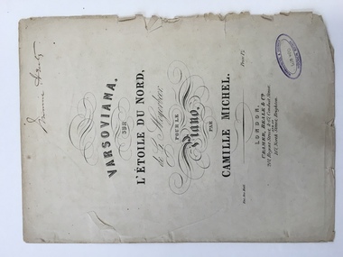 Warrnambool and District Historical Society Inc.
Work on paper - Sheet music, Varsoviana sur L’Etoile Du Nord, 1860s
This piece of music is the varsoviana dance piece from the Giacomo Meyerbeer opera, ‘L’Etoile Du Nord’ arranged by Camille Michel. The varsoviana was a slow graceful dance originating in Poland in 1850 and appearing in Australia in 1856. ‘L’Etoile Du Nord’ was a comic opera in three acts composed by Giacomo Meyerbeer in 1854. Meyerbeer was the most successful stage composer of the 19th century but his works are rarely performed today. Camille Michel was an editor, composer, author and arranger working from the 1840s to the 1880s. The varsoviana music arrangement probably dates from the late 1850s or 1860s. It is not clear who ‘Minnie Henty’ was but it is most likely that she was Minnie Adair who married George Henty, the son of Stephen and Jane Henty, pioneer settlers in Western VictoriaThis sheet music is most important mainly because of the ‘Minnie Henty’ signature. The Henty family members, founders of the first permanent Victorian settlement at Portland, were influential in the history of the Warrnambool area because of their connections with surrounding properties and with coastal shipping. The music also has social significance as an example of music popular in 19th century drawing rooms.This is a two-page piece of sheet music (cover and two pages of music notation) with the material printed in black on cream paper. The back cover is blank and the front cover has the title and names of the composer and the arranger with ornate scrolls around the printing. The edges and fold of the pages are much tattered and torn in some places. There is also a Warrnambool and District Historical Society stamp on the front cover and the signature of Minnie Henty. Front Cover: ‘Minnie Henty’ ‘Varsoviana sur L’Etoile Du Nord de G. Meyerbeer pour le piano par Camille Michel, Ent.Sta.Hall., Price 1s/-, London, Cramer, Beale & Co., 201,Regent Street & 67, Conduit Street and at 167, North Street, Brighton.’ henty family, giacomo meyerbeer, camille michel -
 Melbourne Tram Museum
Photograph - Black & White Photograph/s, Keith Kings, 15/01/1956 12:00:00 AM
Photographs, Black and White, Photo of Q 142 on an all night service to Camberwell at corner of Swanston and Queensberry St, 15/1/1956. Photo by Keith Kings. In the background is Tru-Bake biscuits, Newsagent advertising The Age, Argus, Post, Capstan cigarettes, the Hotel Queensberry, and Davies Coop & Co Limited - Weavers & Underwear Manufacturers.In ink on the rear: Keith Kings stamp and number R(f)(5) "M&MTB - Q-142 as "All Night" tram in Swanston St (North) at Queensberry St corner about to shunt on Xover to return to Camberwell. 7.378am Sunday 15/1/56" 1/250 f4.5trams, tramways, swanston st, queensberry st, all night services, camberwell, tram 142 -
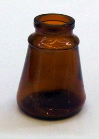 Orbost & District Historical Society
bottles, first half 20th century
Clag was first trademarked in 1898 by Joseph Angus, manufacturer of North Fitzroy, Melbourne. The original paste is thought to have been starch-based. Clag glue was sold in these containers from the early 1900's to the mid 1900's.These items are examples of glass containers used in the early to mid 20th century. Clag glue is an Australian made product still in use today.Two glass Clag bottles . Both are cone shaped and appear to have been sealed with a cork. 2373.1 is a smaller brown glass bottle. 2373.2 is a larger clear glass bottle.2373.1- on base Angus & C0 above ISM Pty Ltd with CLAG on side and numbers 12732 vertically. 2373.2 -on front CONTENTS MADE BY ANGUS & Co PTY Ltd on base - CONTENTS MADE BY ANGUS co PTY ltdjar bottle glue container angus&co clag -
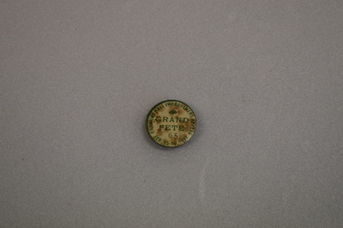 Warrnambool and District Historical Society Inc.
Badge, Panmure Hall Improvement
This badge was sold at a local fete to raise funds for improvements to the Panmure Hall. Panmure is a small town on the Princes Highway 22 kilometres north east of Warrnambool. In 1933 the population of Panmure was 273. The Panmure Hall still serves the community.This badge is of interest as an example of a local community effort to raise funds for local communities.Circular badge with cream background surrounded by a green rim. The text and a fan shaped medallion are also green. A black number is also featured. There is a clip pin on the reverse.PANMURE HALL IMPROVEMENT APPEAL FEB. 15-16. 1933 GRAND FETE 59 -
Glen Eira Historical Society
Article - Imber, Doris
An article from ‘The Age’ dated 21 October 1980 describing Breadmaker Mrs Doris Imber who ran her Doris’s Dough Cooking School from the kitchen of her North Caulfield home. There is a photograph of her in the article.imber doris, doris’s dough cooking school, north caulfield, bread, cooking demonstrations, kitchens, bakers, cooking, home units -
 Mission to Seafarers Victoria
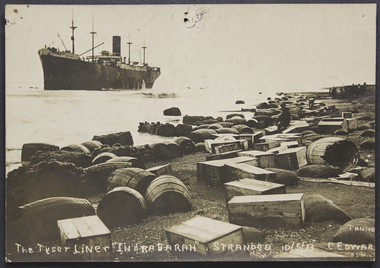
Postcard, The Tyser Liner Indrabarah stranded 10 May 1913 (New Zealand)
The steamer Indrabarah was stranded for 45+ days on the west coast of the north island of New Zealand, before being successfully towed free during a high spring tide. The cargo (mostly frozen meat) was reported to have survived the ordeal. This card (postcard) with print of Liner Indrabarah -
 Greensborough Historical Society
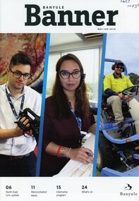
Magazine, Banyule Banner. May-June 2019, 2019_05
The Banyule Banner is published bi-monthly by Banyule City Council to advertise upcoming events in the City of Banyule and to report on past events. This edition includes information on North East Link update, Reconciliation Week and Council's Internship program..A record of events within the City of Banyule.20 pages (approx.), colour illustrations.banyule city council