Showing 1701 items
matching concreting
-
 Tatura Irrigation & Wartime Camps Museum
Photograph, Goulburn Weir, 1890
Taken by photographer for State Rivers and Water Supply Commission.Medium sized black and white photograph. Concrete and iron weir structure, stone spillway, earth bank on West bank below brick control house. Dead trees in water beyond weir, houses on West bankgoulburn weir, victorian state rivers and supply commission -
Tatura Irrigation & Wartime Camps Museum
Photograph, 19/12/1946
Taken by photographer for State Rivers and Water Supply Commission.Medium sized black and white photograph. Waranga Reservoir main outlet - Western main channel looking downstream to Waranga. Concrete bridges and control structure join earthen banks of channel. Windmill mid-left of picture.goulburn weir, victorian state rivers and supply commission -
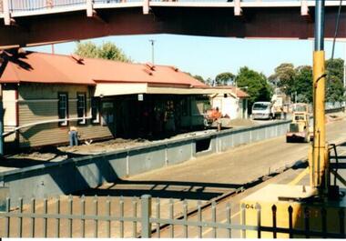 Hume City Civic Collection
Photograph, 21/04/2005
This photograph was taken during the upgrade of the Bendigo Railway line at Sunbury Station. The upgrade took twelve months to complete and during that time buses replaced the trains.A coloured photograph of construction on the site of the Sunbury Railway Station. The photograph was taken from the Bendigo platform and shows the concrete wall which replace the bluestone foundations on the Melbourne side of the station. A workman is on the platform working on the new surface.railways, bendigo line, railway stations, bridges, sunbury railway station, george evans collection -
Lakes Entrance Regional Historical Society (operating as Lakes Entrance History Centre & Museum)
Photograph, Rose Series, 1955 c
Also another colour postcard similar view of footbridge made by Murray Views donor Susan Samuel 2 January 2015 number 04272.1, 9 x 14 cmColour postcard taken from south end of the Cunninghame Arm footbridge showing crowd on bridge, cars parked on Esplanade, new concrete wall between dunes and lake at south end of bridge Lakes Entrance VictoriaThe Foot-Bridge, Lakes Entrance. Vicrecreation, waterfront, land reclamation -
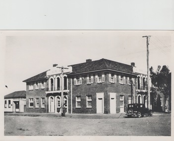 Sunbury Family History and Heritage Society Inc.
Photograph, The Royal Hotel, c1939
The two storey building is the Royal Hotel which is sited on the corner of Brook and Evans Streets in Sunbury's main shopping strip.The photograph was taken sometime in 1939 after it was totally rebuilt. A fire had damaged the old single storey structure, which was built on the same site c1860 shortly after Sunbury had a rail service. The building still operates today on the same site.The Royal Hotel is one of four hotels that were built in Evans Street Sunbury between Brook and Station Streets ion the 1860s shortly after the rail service arrived in the town. They were They were the Railway Hotel (Olive Tree), White Horse Hotel, Royal Hotel and the Rupertswood Hotel, opposite the Royal Hotel. A non-digital black and white photograph with a cream border of a two storey brick hotel building with light concrete trimming around the windows and entrances sited on a corner. A large black sedan car is parked near the corner. royal hotel, hotels -
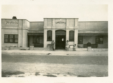 Lakes Entrance Regional Historical Society (operating as Lakes Entrance History Centre & Museum)
Photograph, 1935c
Two other copies identical view size 12.5 x 17.5 cmBlack and white photograph of Heyfield House, showing a large fibro-cement clad building, with name Carstairs on facade. Man, woman and child seated on concrete fence. Couch in alcove with person seated. Lakes Entrance Victoriaguesthouses, architecture, tourism -
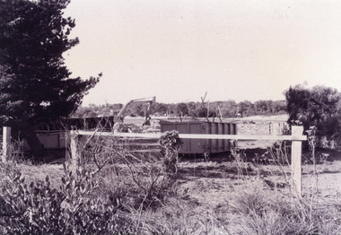 Lakes Entrance Regional Historical Society (operating as Lakes Entrance History Centre & Museum)
Photograph - TAFE site, Fish Marie, 1995
Black and white photograph of the site of Peck's fish processing factory on Bullock Island. It shows a heavy machine in background, broken concrete and rubbish skip in foreground, site cleared for TAFE education complex. Lakes Entrance Victoriaislands, education -
 Eltham District Historical Society Inc
Folder, The Erection of a reinforced bridge at Hurstbridge
Photocopied contract for construction of reinforced concrete bridge by the Shire of Eltham at Hurstbridge dated 5th February 1917, including general conditions of contract. This bridge is known as the Monash bridge.10 PagesHG Folders 115harry gilham collection, hurstbridge, monash bridge, contract -
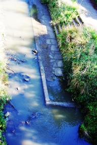 Greensborough Historical Society
Photograph - Digital Image, Old pool Plenty River, May 2014, 21/05/2014
Plenty River pool Greensborough. Opened in 1937, the remnants of this concrete pool can be seen today from the Main Street bridge Greensborough. Photograph by Marilyn Smith 2014.Digital copy of colour photograph.plenty river pool, greensborough pool, swimming pools -
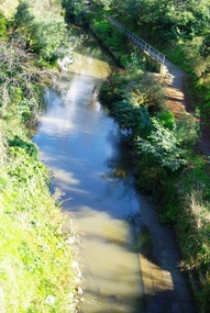 Greensborough Historical Society
Photograph - Digital Image, Old Pool Plenty River 2014, 21/05/2014
Plenty River pool Greensborough. Opened in 1937, the remnants of this concrete pool can be seen today from the Main Street bridge Greensborough. Photograph by Marilyn Smith 2014.Digital copy of colour photograph.plenty river pool, swimming pools, greensborough pool -
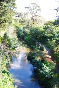 Greensborough Historical Society
Photograph - Digital Image, Old Pool Plenty River May 2014, 21/05/2014
Plenty River pool Greensborough. Opened in 1937, the remnants of this concrete pool can be seen today from the Main Street bridge Greensborough. Photograph by Marilyn Smith 2014.Digital copy of colour photograph.greensborough pool, swimming pools, plenty river pool -
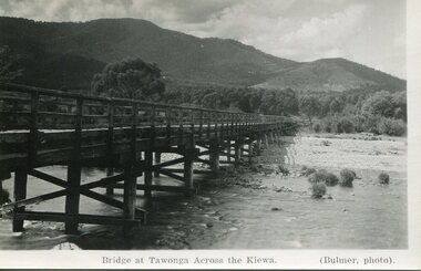 Kiewa Valley Historical Society
Photograph - Bridge at Tawonga 1936, 22/03/1936
First Tawonga bridge was built in 1884- destroyed by floods in 1916. New bridge constructed 1923 and destroyed in 1953. Present concrete bridge constructed in 1986 and named Ryders BridgeBridge construction over Kiewa River at TawongaBlack and white photographic postcard of the bridge at Tawonga across the Kiewa River.Handwritten in pencil on rear of photograph - Sunday 22nd March, 1936. Printed on front - Bridge at Tawonga across the Kiewa (Blumer, photo)tawonga bridge, kiewa valley -
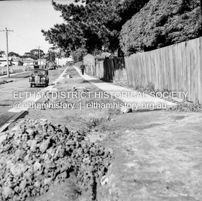 Eltham District Historical Society Inc
Negative - Photograph, J.A. McDonald, Eltham, Pryor Street, Sep. 1955
Construction of new concrete kerbing and footpath in Pryor Street, Eltham The truck on the left of the road is parked ouside the Eltham Police Station at No. 23. On the right is the present-day Woolworths carparkRecord of various Shire of Eltham infrastructure works undertaken during the period of 1952-1962 involving bridge and road reconstruction projects, sometimes with Eltham Shire Council Project Reference numbers quoted. It was during this period that a number of significant improvements were made to roads and new bridges constructed within the shire that remain in place as of present day (2022). In many situations, the photos provide a tangible visible record of infrastructure that existed throughout the early days of the Shire. The album was put together by or under the direction of the Shire Engineer, J.A. McDonald.1955-09, footpaths and gutters, pryor street, eltham police station, infrastructure, shire of eltham -
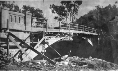 Eltham District Historical Society Inc
Photograph, Hurstbridge - Construction of new bridge
In early November 1917 the new reinforced concrete bridge across the Diamond Creek at Hurstbridge was officially opened with "some 500 spectators", some who had arrived by train for the occassion.This photo forms part of a collection of photographs gathered by the Shire of Eltham for their centenary project book, "Pioneers and Painters: 100 years of the Shire of Eltham" by Alan Marshall (1971). The collection of over 500 images is held in partnership between Eltham District Historical Society and Yarra Plenty Regional Library (Eltham Library) and is now formally known as 'The Shire of Eltham Pioneers Photograph Collection.' It is significant in being the first community sourced collection representing the places and people of the Shire's first one hundred years.Digital imagesepp, shire of eltham pioneers photograph collection, hurstbridge, bridge, bridge construction -
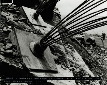 Lorne Historical Society
Photograph, Landslip Great Ocean Road 1971
Repairing land-slip at Windy-Point, showing cables that secured the face of the cliff. These cables ends are cut off and a concrete slab placed over the plate. Working machine below on the G.O.R. and workman holding stop/go sign.land-slip 1971: windy-point; cable-locks. concrete securing blocks. maintenance equipment -
Glenelg Shire Council Cultural Collection
Slide - Slide - Construction Portland/Cashmore Airport, c. 1980
Coloured slide. Deep squirish hole, muddy water in bottom. Rough wooden steps down to water, left hand side of hole. Large concrete pipe on right attached to metal structure which is embedded in bottom of hole. -
Glenelg Shire Council Cultural Collection
Photograph - Photograph - Main Breakwater construction, Portland, 05/06/1959
Port of Portland Authority ArchivesFront: 5/6/59- pencil Back: 5/6/59 - Pencilport of portland archives, harbour construction, main breakwater, wharf, crane -
Glenelg Shire Council Cultural Collection
Photograph - Photograph - Portland Harbour construction, n.d
Port of Portland Authority ArchivesFront: B41 1/5/59- Pencil Back: B14 1/5/59 - Pencilport of portland archives, main breakwater, harbour construction, harbour development -
Glenelg Shire Council Cultural Collection
Photograph - Photograph - Portland Harbour, n.d
Port of Portland Authority ArchivesBack: Border ruled 4 sides 'Reduce to 28 ems wide' - top border 50%- green pencil 14 bottom border - all in pencilport of portland archives, construction, harbour, portland -
Glenelg Shire Council Cultural Collection
Photograph - Photograph - Portland Harbour, n.d
Port of Portland Authority Archivesport of portland archives, reclamation harbour, barge, maritime, portland -
Glenelg Shire Council Cultural Collection
Photograph - Photograph - Silo Construction, c. 1964
Port of Portland Authority ArchivesBack: Blue PHT stamp 19 B 18-12-64 in black inkport of portland archives, silo construction -
Glenelg Shire Council Cultural Collection
Photograph - Photograph - Portland Harbour, n.d
Port of Portland Authority Archivesport of portland archives, portland harbour, construction -
Glenelg Shire Council Cultural Collection
Photograph - Photograph - Main Breakwater Construction, n.d
Port of Portland Authority Archivesport of portland archives, portland harbour -
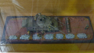 National Vietnam Veterans Museum (NVVM)
Model - Diorama
A diorama of a Centurion MBT mine clearance tank with roller drum configuration. Four x forty-four gallon drums filled with concrete and set on frame of water pipes. These were rolled along in front of the tank to bulldoze soil.mine clearing, centurion tank, roller drum, diorama -
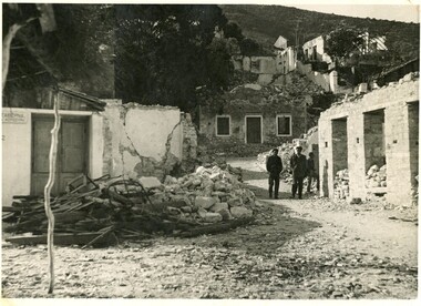 Ithacan Historical Society
Photograph, Ithaca earthquake, 1953
The photograph was taken after the massive earthquakes of 1953 which caused widespread destruction across Ithaca and other Ionian Islands. Many of the buildings destroyed in the earthquake could not be rebuilt and some parts of the villages became uninhabitable. This event brought about the largest mass migration from the island and a further wave of Ithacan migration to countries, such as Australia and South Africa, where relatives had already settled. The Ithacan Philanthropic Society established an Earthquake Appeal to assist their compatriots.A black and white photograph showing widespread damage done in the aftermath of an earthquake. Many houses are in ruins and there are two heaps of rubble comprising timber and metal and concrete in the foreground. Two men are walking along a track looking at the destruction in the village. -
 Bendigo Historical Society Inc.
Slide - ALLAN BUDGE COLLECTION: SLIDE HOUSE, QUEEN STREET, 1988
Slide, Allan Budge Collection: house, Queen Street.Verandah friezes in timber. One of a pair. Timber frieze.The gable treatment gives relief to another dull appearance.(Note: Fluted concrete verandah columns are almost certainly not original.)house, public, allan budge collection:, allan budge collection: -
Tatura Irrigation & Wartime Camps Museum
Photograph, Goulburn Weir, 1890
Taken by photographer for State Rivers and Water Supply Commission.Medium sized black and white photograph. Earthworks foreground, horse and dray lower right, men working on concrete weir structures, middle distance, - river with tree'd banks beyond, workmen's huts and house left of middle distancevictoria state rivers and water supply commission, goulburn weir -
Tatura Irrigation & Wartime Camps Museum
Photograph, Goulburn Weir, 1890
Taken by photographer for State Rivers and Water Supply Commission.Medium sized black and white photograph. View across weir - channel outlet left - earth and rubble wall separates two concrete and iron structures of weir. Trees on bank beyond beyond, buildings scattered amongst trees.victoria state rivers and water supply commission, goulburn weir -
 Bendigo Historical Society Inc.
Photograph - Kangaroo Flat Gold Mine Collection: Catherine Reef South shaft
Black and white photocopy of original photo. Image shows black square checker board steel capping on concrete base. Cap is situated on top of Catherine Reef South shaft, Eaglehawk. Shaft capped by Western Mining Corporation.On back in pencil: Catherine Reef South Shaft, WMC cap.western mining corporation, goldmining, capping, shaft, catherine reef south shaft, mining regulations -
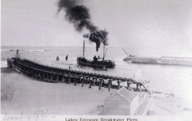 Lakes Entrance Regional Historical Society (operating as Lakes Entrance History Centre & Museum)
Photograph - S.S. Despatch, 1910 c
Black and white photograph showing S S Despatch steaming out the entrance. Photo shows wooden piers with concrete extensions, kiosk beside boardwalk, plenty of black smoke from funnel of ship. Lakes Entrance VictoriaLakes Entrance Breakwater Piers waterways, jetties, ships and shipping