Showing 1105 items
matching historic house
-
 Buninyong & District Historical Society
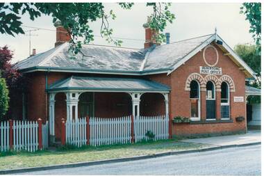
Photograph - Original Photograph, Clive Brooks, Old Buninyong Post Office (1874), Learmonth St. Buninyong, 9 Nov. 1991
detail of historic buildingColour Photograph, Old Buninyong Post Office (1874), Learmonth St. Buninyongbuninyong, church, presbyterian, uniting, learmonth st. -
 Buninyong & District Historical Society
Photograph - Original Photograph, Clive Brooks, Crown Hotel, rear view from DeSoza Park, Nov. 1991
detail of historic buildingColour Photograph, Crown Hotel, rear view from DeSoza Park, Original 1885 slate roof surrounded by 1980's extensions, bottle shop on left, corner shop on other side of Warrenheip St. visible.buninyong, crown hotel, bottle shop -
 Buninyong & District Historical Society
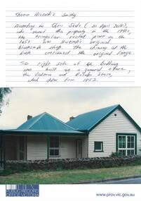
Photograph - Original Photograph, Clive Brooks, 412 Learmonth St. house on land bought by Thomas Hiscock in 1851, thought to include original smithy and residence and shop, Nov. 1991
detail of historic buildingColour Photograph, 412 Learmonth St. house on land bought by Thomas Hiscock in 1851, thought to include original smithy on left, residence and shop on right.buninyong, thomas hiscock, blacksmith, victoria and eureka store, learmonth st. -
 Buninyong & District Historical Society
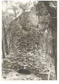
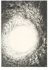
Photograph - Original Photograph, BCAE Metallurgy Staff, Lal Lal Blast Furnace, 1977
detail of historic buildingB/W Photograph, Lal Lal Blast Furnace, exterior in 1977buninyong, lal lal, blast furnace -
 Buninyong & District Historical Society
Photograph - Original Photograph, BCAE Metallurgy Staff, Lal Lal Blast Furnace, interior, 1977
detail of historic buildingB/W Photograph, Lal Lal Blast Furnace, interior, in 1977buninyong, lal lal, blast furnace -
 Buninyong & District Historical Society
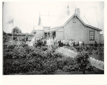
Photograph - Original Photograph, Clarendon State School, ANA Garden Competition 1904, 1988
historic building and occasionB/W Photograph, Clarendon State School, teachers and children awarded first prize in Ballarat Inspectorate in first ANA Garden Competition 1904buninyong, clarendon state school, ana garden competition -
 Buninyong & District Historical Society
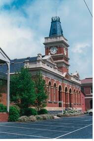
Photograph - Original Photograph, Buninyong Town Hall (1886) front, angle view from North-East, 9/11/1991
historic buildingColour photograph, Buninyong Town Hall (1886) front, angle view from North-East, buninyong, view, town hall -
 Buninyong & District Historical Society
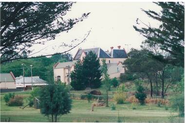
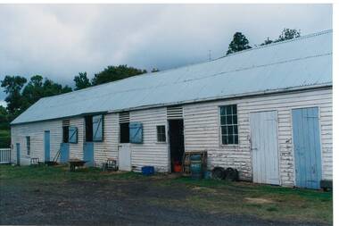
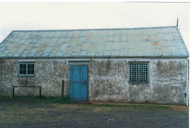
Photograph - Original Photograph, Clive Brooks, Part view of old stables at Mount Boninyong Homestead, 9/11/1991
historic buildingColour photograph, Part view of old stables at Mount Boninyong Homestead, white weatherboard, blue doors.buninyong, mt. boninyong hopmestead, stables, scott -
 Buninyong & District Historical Society
Photograph - Original Photograph, Clive Brooks, North side of old stables at Mount Boninyong Homestead, 9/11/1991
historic buildingColour photograph, north end of old stables at Mount Boninyong Homestead, stucco, traces of whitewash, tin roof, traces of blue paint, blue door.buninyong, mt. boninyong hopmestead, stables, scott -
 Buninyong & District Historical Society
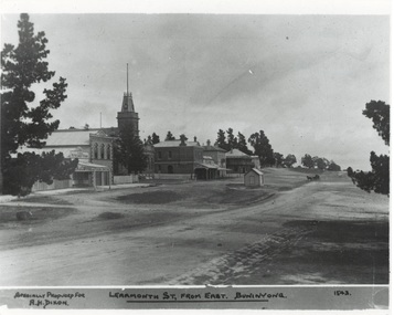
Photograph - Original Photograph, Learmonth St from the east, Town Hall Precinct, early 1900's, 9/11/1991
historic buildingsB/W photograph, Learmonth St from the east, Town Hall Precinct, early 1900's, Refreshment Rooms, Fire Station, Town Hall, Whyke's Butchers, Allan's Store, Bank, Buninyong Inn, toll booth."Specially Produced For A.H. Dixon Learmonth St, from east, Buninyong 1543"buninyong, calf's refreshment rooms, fire station, town hall, whyke's butches, allan store, nab bank, buninyong inn, toll booth -
 Buninyong & District Historical Society
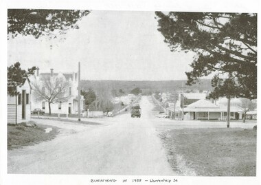
Photograph - Photo of Original Photograph, Warrenheip / Learmonth intersection, looking north up Warrenheip, in 1958, 1995
historic streetscapeB/W photograph, Warrenheip / Learmonth intersection, looking north up Warrenheip, in 1958, Crown Hotel, corner store visible, truck with double layer load of cars heading north."Specially Produced For A.H. Dixon Learmonth St, from east, Buninyong 1543"buninyong, learmonth st., warrenheip st., intersection, crown hotel, corner store -
 Buninyong & District Historical Society
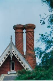
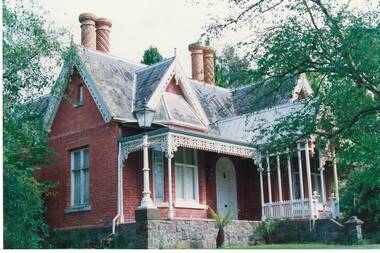
Photograph - Original Photograph, Clifton Villa (1859) Eyre St. Buninyong, close-up of chimneys, 9/11/1991
detail of feature of historic buildingColour photograph, Clifton Villa (1859) Eyre St. Buninyong, close-up of chimneys.buninyong, clifton villa, chimney -
 Buninyong & District Historical Society
Photograph - Original Photograph, Clifton Villa (1859) Eyre St. Buninyong, front (east side), 9/11/1991
historic building, after restorationColour photograph, Clifton Villa (1859) Eyre St. Buninyong, front (east side), 3/4 view.buninyong, clifton villa, chimney -
 Buninyong & District Historical Society
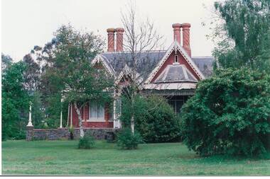
Photograph - Original Photograph, Clifton Villa (1859) Eyre St. Buninyong, front (east side), full on, 9/11/1991
historic building, after restorationColour photograph, Clifton Villa (1859) Eyre St. Buninyong, front (east side).buninyong, clifton villa, chimney -
 Buninyong & District Historical Society
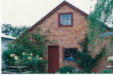
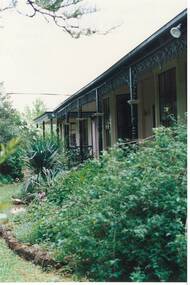
Photograph - Original Photograph, Robert Allen's house (1856-57) Eyre St. Buninyong, outhouse, rebuilt 1988, incorporating part of original stable, 9/11/1991
historic building, rebuildingColour photograph, Robert Allen's house (1856-57) Eyre St. Buninyong, outhouse, rebuilt 1988, incorporating part of original stable.buninyong, outhouse, robert allen -
 Buninyong & District Historical Society
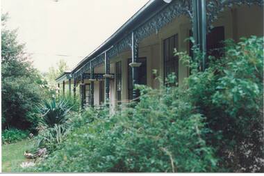
Photograph - Original Photograph, Robert Allen's house (1856-57) Eyre St. Buninyong, front verandah, 9/11/1991
historic building, Colour photograph, Robert Allen's house (1856-57) Eyre St. Buninyong, front verandah.buninyong, robert allen -
 Buninyong & District Historical Society
Photograph - Original Photograph, Robert Allen's house (1856-57) Eyre St. Buninyong, front verandah, 9/11/1991
historic building, Colour photograph, Robert Allen's house (1856-57) Eyre St. Buninyong, front verandah.buninyong, robert allen -
 Kew Historical Society Inc
Plan, Melbourne & Metropolitan Board of Works : Borough of Kew : Detail Plan No.1585, 1904
The Melbourne and Metropolitan Board of Works (MMBW) plans were produced from the 1890s to the 1950s. They were crucial to the design and development of Melbourne's sewerage and drainage system. The plans, at a scale of 40 feet to 1 inch (1:480), provide a detailed historical record of Melbourne streetscapes and environmental features. Each plan covers one or two street blocks (roughly six streets), showing details of buildings, including garden layouts and ownership boundaries, and features such as laneways, drains, bridges, parks, municipal boundaries and other prominent landmarks as they existed at the time each plan was produced. (Source: State Library of Victoria)This plan forms part of a large group of MMBW plans and maps that was donated to the Society by the Mr Poulter, City Engineer of the City of Kew in 1989. Within this collection, thirty-five hand-coloured plans, backed with linen, are of statewide significance as they include annotations that provide details of construction materials used in buildings in the first decade of the 20th century as well as additional information about land ownership and usage. The copies in the Public Record Office Victoria and the State Library of Victoria are monochrome versions which do not denote building materials so that the maps in this collection are invaluable and unique tools for researchers and heritage consultants. A number of the plans are not held in the collection of the State Library of Victoria so they have the additional attribute of rarity.Original survey plan, issued by the MMBW to a contractor with responsibility for constructing sewers in the area identified on the plan within the Borough of Kew. The plan was at some stage hand-coloured, possibly by the contractor, but more likely by officers working in the Engineering Department of the Borough and later Town, then City of Kew. The hand-coloured sections of buildings on the plan were used to denote masonry or brick constructions (pink), weatherboard constructions (yellow), and public buildings (grey). This plan, which covers parts of High Street, Pakington Street and Derby Street is dominated by two historic Kew mansions: ‘Konetta’ and ‘Ramornie’. Ramornie was constructed in 1890 for James Maitland Campbell, three times Mayor of Kew. Sold in 1940, it became a boarding house known as ‘The Towers’. Now a private residence again, it has only one of its three balconies remaining. The location of the missing two balconies can be seen on the plan. In 1903, the grounds of Ramornie included a large tennis court fronting Pakington Street. The rear of the property is shown as extending to Cobden Street. One of Kew’s oldest hotels, the Prospect Hill Hotel on the corner of High and Cobden Street was established in 1858. The outline of the hotel shown on the plan represents the second building on the site. During the 19th century it was often used for electoral meetings. The Prospect Hill Hotel was to be redeveloped again in 1928, by the local architect Robert McIntyre. Since the 1980s, the hotel has been a live music venue, the home of the Melbourne Jazz Club, a restaurant and a liquor outlet.melbourne and metropolitan board of works, detail plans, maps - borough of kew, mmbw 1585, cartography -
 Kew Historical Society Inc
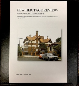
Archive (Sub-series) - Subject File, Kew Heritage Review, Residential Places Graded B, Volume 3, 1999, 1999
Graeme Butler & AssociatesProject FilesProvenance OrderBlack 4-Ring binder that includes research about, and an assessment of buildings previously graded B in the City of Kew Urban Conservation Study 1988 by Pru Sanderson Design Pty Ltd. The files were created by the heritage architect Graeme Butler and the paper files include maps, correspondence, title searches, readings, reviews of prior classifications, newspaper and journal articles, directories etc for each property assessed.graeme butler, heritage reviews - kew, 4 cameron court, 2 hodgson street, 20 fellows street, 26 fellows street, 23 highbury grove, kew lunatic asylum, kew mental hospital, willsmere, 36 stawell street, 13 studley avenue, 16 studley avenue, 20 studley avenue, raheen, studley park road, beament house, 33 uvadale road, 20 yarra streetgraeme butler, heritage reviews - kew, 4 cameron court, 2 hodgson street, 20 fellows street, 26 fellows street, 23 highbury grove, kew lunatic asylum, kew mental hospital, willsmere, 36 stawell street, 13 studley avenue, 16 studley avenue, 20 studley avenue, raheen, studley park road, beament house, 33 uvadale road, 20 yarra street -
 Kew Historical Society Inc
Archive (Sub-series) - Subject File, Kew Historical Society, Kew Association, 1974
Various partiesReference, Research, InformationSecondary valuesSubject file on ‘The Kew Association’ formed in 1974 as a separate group to the Kew Historical Society. Its constitution, which is filed, is general in nature. One part of the Association’s interests was the formation of a Historical Working Group to ‘examine historic buildings and other aspects of Kew’s history’. A founding member of the Society, Joy Stewart, was its convenor. By June 1974 it had 133 members. It differed from the Society in that it specifically aimed to improve Council services. One of its achievements was to begin a ‘historical home survey’ by street. The survey documents in the file list street name, number of house, side of street, size of house and general observations. Other information in the archive file includes correspondence, agendas, minutes etc. of the Association. As these only cover the years 1974-5, this may have been the period in which the group operated.kew - history, kew association - kew (vic), community groups - kew (vic), heritage - kew (vic)kew - history, kew association - kew (vic), community groups - kew (vic), heritage - kew (vic) -
 Kew Historical Society Inc
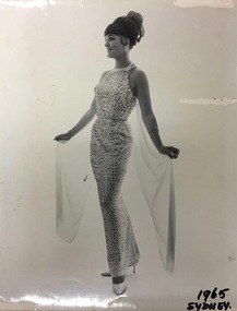
Photograph, Greg Desmond, Publicity Photograph, Robin Vanser, Sydney, 1965, 1965
Robin Kelly was born Robin Vandersluys in Mary Street, Kew. As a child, she sang in backyard concerts run with her brother, Leslie. The family moved to Deepdene in 1949 and Robin joined church and school choirs. Later she was to study classical singing with Stella Power, modern singing with Jack White, TV Presentation with Natalie Raine of Crawford Productions and acting/singing with Jessie Matthews. Following her victory in a talent quest at the Orama Ballroom, she was invited to join the Orama Big Band with singers Harry Cox and Arlene Forrest. She also sang with the Kerm Jones Jazz Band at Power House and with Frank Johnson's Jazz Band at Jazz Junction. Robin became resident band vocalist at the historic Federal Hotel in Collins Street with the Rudi Laquer Trio. She also sang at The Savoy Plaza with the George Cadman Trio. A year later she became resident vocalist at the Ress Oriental Hotel with the Lennie Holmes Trio. Later, Robin married pianist Peter Jones, singing under the name 'Robin Vanser' in clubs in Sydney and regional New South Wales. She was booked for a Vietnam War tour and also sang in Tahiti. Returning to Melbourne, her agent booked her to appear in shows in Tasmania including West Point Casino and Melbourne country venues. Another agent, John Bishop, booked her to do floor shows in Melbourne, including Xmas Seasons at the Hampton Hotel where she entertained audiences with her comedy and audience participation routines. In 1971, Robin Kelly retired to run her Robin Hood Antiques business in Canterbury, during which time she was married to tenor Glenn Kelly. Later she joined Sing Australia Camberwell Choir, performing as a soloist at their Melbourne Town Hall Concert.The Vandersluys-Kelly Collection of photographs, costumes and musical performance memorabilia was donated to the Kew Historical Society by Robin Denise Kelly in 2018. The collection is an important record of stage and recorded performances in Australia in the second half of the 20th century. This new nationally-focused and artistically significant collection augments and contextualises the local performing arts materials in our collection.Black and white publicity photograph of Robin Vanser (aka Robin Kelly nee Vandersluys) taken while performing in Sydney in 1965 by the photographer Greg Desmond, Ray Leighton Associates."1965, SYDNEY"robin vanser, perfoming arts - australia - 1960s, greg desmond (photographer), ray leighton associates - sydney - new south wales - australia (photographers) -
 Kew Historical Society Inc
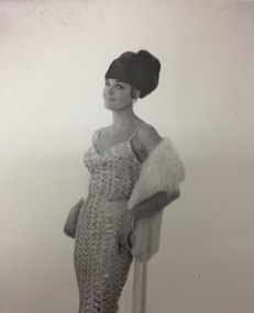
Photograph, Greg Desmond, Publicity Photograph, Robin Vanser, Sydney, 1965, 1965
Robin Kelly was born Robin Vandersluys in Mary Street, Kew. As a child, she sang in backyard concerts run with her brother, Leslie. The family moved to Deepdene in 1949 and Robin joined church and school choirs. Later she was to study classical singing with Stella Power, modern singing with Jack White, TV Presentation with Natalie Raine of Crawford Productions and acting/singing with Jessie Matthews. Following her victory in a talent quest at the Orama Ballroom, she was invited to join the Orama Big Band with singers Harry Cox and Arlene Forrest. She also sang with the Kerm Jones Jazz Band at Power House and with Frank Johnson's Jazz Band at Jazz Junction. Robin became resident band vocalist at the historic Federal Hotel in Collins Street with the Rudi Laquer Trio. She also sang at The Savoy Plaza with the George Cadman Trio. A year later she became resident vocalist at the Ress Oriental Hotel with the Lennie Holmes Trio. Later, Robin married pianist Peter Jones, singing under the name 'Robin Vanser' in clubs in Sydney and regional New South Wales. She was booked for a Vietnam War tour and also sang in Tahiti. Returning to Melbourne, her agent booked her to appear in shows in Tasmania including West Point Casino and Melbourne country venues. Another agent, John Bishop, booked her to do floor shows in Melbourne, including Xmas Seasons at the Hampton Hotel where she entertained audiences with her comedy and audience participation routines. In 1971, Robin Kelly retired to run her Robin Hood Antiques business in Canterbury, during which time she was married to tenor Glenn Kelly. Later she joined Sing Australia Camberwell Choir, performing as a soloist at their Melbourne Town Hall Concert.The Vandersluys-Kelly Collection of photographs, costumes and musical performance memorabilia was donated to the Kew Historical Society by Robin Denise Kelly in 2018. The collection is an important record of stage and recorded performances in Australia in the second half of the 20th century. This new nationally-focused and artistically significant collection augments and contextualises the local performing arts materials in our collection.Black and white publicity photograph of Robin Vanser (aka Robin Kelly nee Vandersluys) taken while performing in Sydney in 1965 by the photographer Greg Desmond, Ray Leighton Associates.PHOTOGRAPHED BY GREG DESMOND RAY LEIGHTON ASSOCIATES 278294-272231robin vanser, perfoming arts - australia - 1960s, greg desmond (photographer), ray leighton associates - sydney - new south wales - australia (photographers) -
 Kew Historical Society Inc
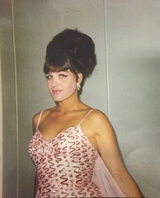
Photograph, Greg Desmond, Publicity Photograph, Robin Vanser, Sydney, 1965, 1965
Robin Kelly was born Robin Vandersluys in Mary Street, Kew. As a child, she sang in backyard concerts run with her brother, Leslie. The family moved to Deepdene in 1949 and Robin joined church and school choirs. Later she was to study classical singing with Stella Power, modern singing with Jack White, TV Presentation with Natalie Raine of Crawford Productions and acting/singing with Jessie Matthews. Following her victory in a talent quest at the Orama Ballroom, she was invited to join the Orama Big Band with singers Harry Cox and Arlene Forrest. She also sang with the Kerm Jones Jazz Band at Power House and with Frank Johnson's Jazz Band at Jazz Junction. Robin became resident band vocalist at the historic Federal Hotel in Collins Street with the Rudi Laquer Trio. She also sang at The Savoy Plaza with the George Cadman Trio. A year later she became resident vocalist at the Ress Oriental Hotel with the Lennie Holmes Trio. Later, Robin married pianist Peter Jones, singing under the name 'Robin Vanser' in clubs in Sydney and regional New South Wales. She was booked for a Vietnam War tour and also sang in Tahiti. Returning to Melbourne, her agent booked her to appear in shows in Tasmania including West Point Casino and Melbourne country venues. Another agent, John Bishop, booked her to do floor shows in Melbourne, including Xmas Seasons at the Hampton Hotel where she entertained audiences with her comedy and audience participation routines. In 1971, Robin Kelly retired to run her Robin Hood Antiques business in Canterbury, during which time she was married to tenor Glenn Kelly. Later she joined Sing Australia Camberwell Choir, performing as a soloist at their Melbourne Town Hall Concert.The Vandersluys-Kelly Collection of photographs, costumes and musical performance memorabilia was donated to the Kew Historical Society by Robin Denise Kelly in 2018. The collection is an important record of stage and recorded performances in Australia in the second half of the 20th century. This new nationally-focused and artistically significant collection augments and contextualises the local performing arts materials in our collection.Colour publicity photograph of Robin Vanser (aka Robin Kelly nee Vandersluys) taken while performing in Sydney in 1965 by the photographer Greg Desmond, Ray Leighton Associates.robin vanser, perfoming arts - australia - 1960s, greg desmond (photographer), ray leighton associates - sydney - new south wales - australia (photographers) -
 Kew Historical Society Inc
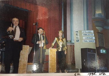
Photograph, Robin Vanser and Six-Piece Band, Hawthorn Town Hall, 1995, 1995
Robin Kelly was born Robin Vandersluys in Mary Street, Kew. As a child, she sang in backyard concerts run with her brother, Leslie. The family moved to Deepdene in 1949 and Robin joined church and school choirs. Later she was to study classical singing with Stella Power, modern singing with Jack White, TV Presentation with Natalie Raine of Crawford Productions and acting/singing with Jessie Matthews. Following her victory in a talent quest at the Orama Ballroom, she was invited to join the Orama Big Band with singers Harry Cox and Arlene Forrest. She also sang with the Kerm Jones Jazz Band at Power House and with Frank Johnson's Jazz Band at Jazz Junction. Robin became resident band vocalist at the historic Federal Hotel in Collins Street with the Rudi Laquer Trio. She also sang at The Savoy Plaza with the George Cadman Trio. A year later she became resident vocalist at the Ress Oriental Hotel with the Lennie Holmes Trio. Later, Robin married pianist Peter Jones, singing under the name 'Robin Vanser' in clubs in Sydney and regional New South Wales. She was booked for a Vietnam War tour and also sang in Tahiti. Returning to Melbourne, her agent booked her to appear in shows in Tasmania including West Point Casino and Melbourne country venues. Another agent, John Bishop, booked her to do floor shows in Melbourne, including Xmas Seasons at the Hampton Hotel where she entertained audiences with her comedy and audience participation routines. In 1971, Robin Kelly retired to run her Robin Hood Antiques business in Canterbury, during which time she was married to tenor Glenn Kelly. Later she joined Sing Australia Camberwell Choir, performing as a soloist at their Melbourne Town Hall Concert.The Vandersluys-Kelly Collection of photographs, costumes and musical performance memorabilia was donated to the Kew Historical Society by Robin Denise Kelly in 2018. The collection is an important record of stage and recorded performances in Australia in the second half of the 20th century. This new nationally-focused and artistically significant collection augments and contextualises the local performing arts materials in our collection.Colour photograph of Robin Vanser (aka Robin Kelly nee Vandersluys) taken while performing at Hawthorn Town Hall in 1995."6 PCE. 1995. HTC HAW. T. HALL / 1995"robin vanser, performing arts - australia - 1990s, hawthorn town hall -
 Kew Historical Society Inc
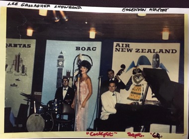
Photograph, Robin Vanser, Lee Gallagher Show Band, Essendon Airport, 1960s, 1960s
Robin Kelly was born Robin Vandersluys in Mary Street, Kew. As a child, she sang in backyard concerts run with her brother, Leslie. The family moved to Deepdene in 1949 and Robin joined church and school choirs. Later she was to study classical singing with Stella Power, modern singing with Jack White, TV Presentation with Natalie Raine of Crawford Productions and acting/singing with Jessie Matthews. Following her victory in a talent quest at the Orama Ballroom, she was invited to join the Orama Big Band with singers Harry Cox and Arlene Forrest. She also sang with the Kerm Jones Jazz Band at Power House and with Frank Johnson's Jazz Band at Jazz Junction. Robin became resident band vocalist at the historic Federal Hotel in Collins Street with the Rudi Laquer Trio. She also sang at The Savoy Plaza with the George Cadman Trio. A year later she became resident vocalist at the Ress Oriental Hotel with the Lennie Holmes Trio. Later, Robin married pianist Peter Jones, singing under the name 'Robin Vanser' in clubs in Sydney and regional New South Wales. She was booked for a Vietnam War tour and also sang in Tahiti. Returning to Melbourne, her agent booked her to appear in shows in Tasmania including West Point Casino and Melbourne country venues. Another agent, John Bishop, booked her to do floor shows in Melbourne, including Xmas Seasons at the Hampton Hotel where she entertained audiences with her comedy and audience participation routines. In 1971, Robin Kelly retired to run her Robin Hood Antiques business in Canterbury, during which time she was married to tenor Glenn Kelly. Later she joined Sing Australia Camberwell Choir, performing as a soloist at their Melbourne Town Hall Concert.The Vandersluys-Kelly Collection of photographs, costumes and musical performance memorabilia was donated to the Kew Historical Society by Robin Denise Kelly in 2018. The collection is an important record of stage and recorded performances in Australia in the second half of the 20th century. This new nationally-focused and artistically significant collection augments and contextualises the local performing arts materials in our collection.Colour photograph of Robin Vanser performing with the Lee Gallagher Show Band in "The Cockpit", Essendon Airport, September 1964"Lee Gallagher Show Band / Essendon Airport / "Cockpit" Sept '64"robin vanser, lee gallagher show band, "the cockpit" - essendon airport, performing arts - australia - 1960s -
 Kew Historical Society Inc
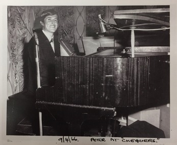
Photograph, Peter Jones, Chequers, Sydney, 1966, 1966
Robin Kelly was born Robin Vandersluys in Mary Street, Kew. As a child, she sang in backyard concerts run with her brother, Leslie. The family moved to Deepdene in 1949 and Robin joined church and school choirs. Later she was to study classical singing with Stella Power, modern singing with Jack White, TV Presentation with Natalie Raine of Crawford Productions and acting/singing with Jessie Matthews. Following her victory in a talent quest at the Orama Ballroom, she was invited to join the Orama Big Band with singers Harry Cox and Arlene Forrest. She also sang with the Kerm Jones Jazz Band at Power House and with Frank Johnson's Jazz Band at Jazz Junction. Robin became resident band vocalist at the historic Federal Hotel in Collins Street with the Rudi Laquer Trio. She also sang at The Savoy Plaza with the George Cadman Trio. A year later she became resident vocalist at the Ress Oriental Hotel with the Lennie Holmes Trio. Later, Robin married pianist Peter Jones, singing under the name 'Robin Vanser' in clubs in Sydney and regional New South Wales. She was booked for a Vietnam War tour and also sang in Tahiti. Returning to Melbourne, her agent booked her to appear in shows in Tasmania including West Point Casino and Melbourne country venues. Another agent, John Bishop, booked her to do floor shows in Melbourne, including Xmas Seasons at the Hampton Hotel where she entertained audiences with her comedy and audience participation routines. In 1971, Robin Kelly retired to run her Robin Hood Antiques business in Canterbury, during which time she was married to tenor Glenn Kelly. Later she joined Sing Australia Camberwell Choir, performing as a soloist at their Melbourne Town Hall Concert.The Vandersluys-Kelly Collection of photographs, costumes and musical performance memorabilia was donated to the Kew Historical Society by Robin Denise Kelly in 2018. The collection is an important record of stage and recorded performances in Australia in the second half of the 20th century. This new nationally-focused and artistically significant collection augments and contextualises the local performing arts materials in our collection.Black and white photograph of the pianist Peter Jones, husband of Robin Vanser (Kelly nee Vandersluys), at Chequers, Sydney in April 1966.robin vanser, chequers - sydney - 1960s, performing arts - australia - 1960s -
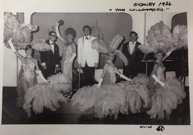 Kew Historical Society Inc
Photograph, Robin Vanser, The Colonnades, Sydney, 1966, 1966
Robin Kelly was born Robin Vandersluys in Mary Street, Kew. As a child, she sang in backyard concerts run with her brother, Leslie. The family moved to Deepdene in 1949 and Robin joined church and school choirs. Later she was to study classical singing with Stella Power, modern singing with Jack White, TV Presentation with Natalie Raine of Crawford Productions and acting/singing with Jessie Matthews. Following her victory in a talent quest at the Orama Ballroom, she was invited to join the Orama Big Band with singers Harry Cox and Arlene Forrest. She also sang with the Kerm Jones Jazz Band at Power House and with Frank Johnson's Jazz Band at Jazz Junction. Robin became resident band vocalist at the historic Federal Hotel in Collins Street with the Rudi Laquer Trio. She also sang at The Savoy Plaza with the George Cadman Trio. A year later she became resident vocalist at the Ress Oriental Hotel with the Lennie Holmes Trio. Later, Robin married pianist Peter Jones, singing under the name 'Robin Vanser' in clubs in Sydney and regional New South Wales. She was booked for a Vietnam War tour and also sang in Tahiti. Returning to Melbourne, her agent booked her to appear in shows in Tasmania including West Point Casino and Melbourne country venues. Another agent, John Bishop, booked her to do floor shows in Melbourne, including Xmas Seasons at the Hampton Hotel where she entertained audiences with her comedy and audience participation routines. In 1971, Robin Kelly retired to run her Robin Hood Antiques business in Canterbury, during which time she was married to tenor Glenn Kelly. Later she joined Sing Australia Camberwell Choir, performing as a soloist at their Melbourne Town Hall Concert.The Vandersluys-Kelly Collection of photographs, costumes and musical performance memorabilia was donated to the Kew Historical Society by Robin Denise Kelly in 2018. The collection is an important record of stage and recorded performances in Australia in the second half of the 20th century. This new nationally-focused and artistically significant collection augments and contextualises the local performing arts materials in our collection.Black and white photograph of the singer Robin Vanser in performance with fellow artists and dancers at 'The Colonnades. Sydney, 1966robin vanser, performing arts - australia - 1960s, the colonnades - sydney - 1966 -
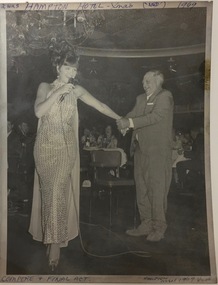 Kew Historical Society Inc
Photograph, Robin Vanser, Hampton Hotel, Xmas 1969, 1969
Robin Kelly was born Robin Vandersluys in Mary Street, Kew. As a child, she sang in backyard concerts run with her brother, Leslie. The family moved to Deepdene in 1949 and Robin joined church and school choirs. Later she was to study classical singing with Stella Power, modern singing with Jack White, TV Presentation with Natalie Raine of Crawford Productions and acting/singing with Jessie Matthews. Following her victory in a talent quest at the Orama Ballroom, she was invited to join the Orama Big Band with singers Harry Cox and Arlene Forrest. She also sang with the Kerm Jones Jazz Band at Power House and with Frank Johnson's Jazz Band at Jazz Junction. Robin became resident band vocalist at the historic Federal Hotel in Collins Street with the Rudi Laquer Trio. She also sang at The Savoy Plaza with the George Cadman Trio. A year later she became resident vocalist at the Ress Oriental Hotel with the Lennie Holmes Trio. Later, Robin married pianist Peter Jones, singing under the name 'Robin Vanser' in clubs in Sydney and regional New South Wales. She was booked for a Vietnam War tour and also sang in Tahiti. Returning to Melbourne, her agent booked her to appear in shows in Tasmania including West Point Casino and Melbourne country venues. Another agent, John Bishop, booked her to do floor shows in Melbourne, including Xmas Seasons at the Hampton Hotel where she entertained audiences with her comedy and audience participation routines. In 1971, Robin Kelly retired to run her Robin Hood Antiques business in Canterbury, during which time she was married to tenor Glenn Kelly. Later she joined Sing Australia Camberwell Choir, performing as a soloist at their Melbourne Town Hall Concert.The Vandersluys-Kelly Collection of photographs, costumes and musical performance memorabilia was donated to the Kew Historical Society by Robin Denise Kelly in 2018. The collection is an important record of stage and recorded performances in Australia in the second half of the 20th century. This new nationally-focused and artistically significant collection augments and contextualises the local performing arts materials in our collection.Black and white photograph of Robin Vanser in performance at the Hampton Hotel, Xmas 1969robin vanser, performing arts - australia - 1960s, performances - hampton hotel - 1960s -
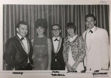 Kew Historical Society Inc
Photograph, Robin Vanser, with Fellow Artists, 1965, 1965
Robin Kelly was born Robin Vandersluys in Mary Street, Kew. As a child, she sang in backyard concerts run with her brother, Leslie. The family moved to Deepdene in 1949 and Robin joined church and school choirs. Later she was to study classical singing with Stella Power, modern singing with Jack White, TV Presentation with Natalie Raine of Crawford Productions and acting/singing with Jessie Matthews. Following her victory in a talent quest at the Orama Ballroom, she was invited to join the Orama Big Band with singers Harry Cox and Arlene Forrest. She also sang with the Kerm Jones Jazz Band at Power House and with Frank Johnson's Jazz Band at Jazz Junction. Robin became resident band vocalist at the historic Federal Hotel in Collins Street with the Rudi Laquer Trio. She also sang at The Savoy Plaza with the George Cadman Trio. A year later she became resident vocalist at the Ress Oriental Hotel with the Lennie Holmes Trio. Later, Robin married pianist Peter Jones, singing under the name 'Robin Vanser' in clubs in Sydney and regional New South Wales. She was booked for a Vietnam War tour and also sang in Tahiti. Returning to Melbourne, her agent booked her to appear in shows in Tasmania including West Point Casino and Melbourne country venues. Another agent, John Bishop, booked her to do floor shows in Melbourne, including Xmas Seasons at the Hampton Hotel where she entertained audiences with her comedy and audience participation routines. In 1971, Robin Kelly retired to run her Robin Hood Antiques business in Canterbury, during which time she was married to tenor Glenn Kelly. Later she joined Sing Australia Camberwell Choir, performing as a soloist at their Melbourne Town Hall Concert.The Vandersluys-Kelly Collection of photographs, costumes and musical performance memorabilia was donated to the Kew Historical Society by Robin Denise Kelly in 2018. The collection is an important record of stage and recorded performances in Australia in the second half of the 20th century. This new nationally-focused and artistically significant collection augments and contextualises the local performing arts materials in our collection.Black and white photograph of Robin Vanser with fellow performers in Sydney, 1965. The other performers are identified as Johnny Rae, Alan Turnbull, Dinah Lee, and Ray Gallagher."Johnny Rae, Alan Turnbull, Dinah Lee, Ray Gallagher (Band leader)performing arts - australia - 1960s, robin vanser, johnny rae, alan turnbull, dinah lee, ray gallagher -
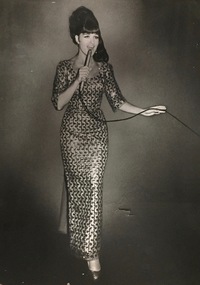 Kew Historical Society Inc
Photograph, Robin Vanser, Wentworth Hotel, Sydney, 1966, 1966
Robin Kelly was born Robin Vandersluys in Mary Street, Kew. As a child, she sang in backyard concerts run with her brother, Leslie. The family moved to Deepdene in 1949 and Robin joined church and school choirs. Later she was to study classical singing with Stella Power, modern singing with Jack White, TV Presentation with Natalie Raine of Crawford Productions and acting/singing with Jessie Matthews. Following her victory in a talent quest at the Orama Ballroom, she was invited to join the Orama Big Band with singers Harry Cox and Arlene Forrest. She also sang with the Kerm Jones Jazz Band at Power House and with Frank Johnson's Jazz Band at Jazz Junction. Robin became resident band vocalist at the historic Federal Hotel in Collins Street with the Rudi Laquer Trio. She also sang at The Savoy Plaza with the George Cadman Trio. A year later she became resident vocalist at the Ress Oriental Hotel with the Lennie Holmes Trio. Later, Robin married pianist Peter Jones, singing under the name 'Robin Vanser' in clubs in Sydney and regional New South Wales. She was booked for a Vietnam War tour and also sang in Tahiti. Returning to Melbourne, her agent booked her to appear in shows in Tasmania including West Point Casino and Melbourne country venues. Another agent, John Bishop, booked her to do floor shows in Melbourne, including Xmas Seasons at the Hampton Hotel where she entertained audiences with her comedy and audience participation routines. In 1971, Robin Kelly retired to run her Robin Hood Antiques business in Canterbury, during which time she was married to tenor Glenn Kelly. Later she joined Sing Australia Camberwell Choir, performing as a soloist at their Melbourne Town Hall Concert.The Vandersluys-Kelly Collection of photographs, costumes and musical performance memorabilia was donated to the Kew Historical Society by Robin Denise Kelly in 2018. The collection is an important record of stage and recorded performances in Australia in the second half of the 20th century. This new nationally-focused and artistically significant collection augments and contextualises the local performing arts materials in our collection.Black and white photograph of Robin Vanser performing at the Wentworth Hotel, Sydney, 1966.performing arts - australia - 1960s, robin vanser, musical performances - wentworth hotel - sydney - 1960s