Showing 11595 items matching " map"
-
 Federation University Historical Collection
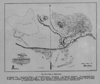
Image, The First Map of Melbourne, 1837
Scanned from "The Old Pioneers' Memorial History of Melbourne From the Discovery of Port Phillip to the World War".First map of Melbourne showing the location of Batman's Hill, Batman's House, Lonsdale's Residence, Commissarist Stores, location of John Falwkner, R. Webb, D'Acry, Carr, Diprose, Nodin, Robson, Alex Thompson, Surveyors tents, Burial Hill (AKA Flagstaff Hill)port phillip bay, batman's hill, batman's house, lonsdale's residence, commissarist stores, john fawkner, r. webb, d'acry, carr, diprose, nodin, robson, alex thompson, surveyors tents, burial hill, flagstaff hill -
 Ballarat Heritage Services
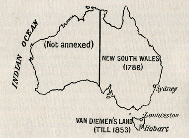
Map, Australian Colonies (States), c1918
Copy of a map from 'A Short History of Australia' by Ernest Scott published in 1918. map, australia, indian ocean, van dieman's land, tasmania, new south wales, sydney, western australia, perth, albany, launceston, hobart, south australia, melbourne, townsville, rockhampton, brisbane, northern territory, queensland -
 Wangaratta RSL Sub Branch
Mixed media - Framed Map and Newspaper, Peter Muncey, 23/7/1943
Sketch Map of Bulldog-Wau Road New Guinea drawn to scale by 2/1 Aust Fd Coy dated 23.7.43 and signed by soldiers together with related newspaper article. Hand sketched by Peter Muncey VX10042 a Draughtsman who served in the Middle East Ceylon and New Guinea with the 2/2 and 2/1 Field Coy Royal Australian Engineers. The sketch contains 26 signatures including:- S/Sgt Raymond Hector Ibbotson NX14112 who served in the Middle East and New Guinea Lt Col Jack Graham Wilson NX 130646Bulldog Track also known as Bulldog-Wau road was longer, higher, steeper, wetter, colder and rougher than Kokoda Track. In 1943 Australian Army engineers; the 2/1 and 2/16 Field Company RAE, 9th Australian Field Company (AIF), veterans of Syria, Palestine, Egypt, Greece and Crete, the 1st and 3rd Australian Pack Transport Companies and local Papuan labour cut the road with pickaxes and dynamite over a period of eight months. During five months of operations over seventy per cent of the 2/1 Australian Field Company contracted malaria.Seventeen bridges were constructed; mostly single, but at least one with multiple spans. More than two thousand Australian army personnel and over two thousand Papuans and New Guineans were involved during nine months of construction. Thus the road, acclaimed as the greatest military engineering feat ever, was completed and for the only time in history motor vehicles crossed the high rugged mountains of Papua New Guinea. Carved brown timber frame with cream mount containing hand sketched map with soldiers signatures and two newspaper articles.Sketch Map of Bulldog-Wau Road 23.7.43 2/1 Aust Fd Coy Newspaper - Diggers pushed on with pick and shovelbulldog-wau road, map, new guinea, ww2, 2/1 aust field coy -
 Bendigo Military Museum
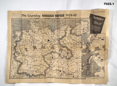
Newspaper - NEWSPAPER EXTRACTS
The various map extract showed the position of the German Control of Europe at the point of time in 1944 and April 1945 near the end. Was for general issue at a time when Allied Forces were on top moving towards German lines.Yellow faded paper, black writing and b & W photos. 1. Four page extract from Newspaper "The Sun" with centre pages having a detailed map of the European Theatre of War dated 11 April 1945. front and Back pages covering normal news items. 2. Four page extract from "The Sun" newspaper giving a phasing of German control of Europe over period of War and a detailed map of position as at 5th August 1944. Final page lists key dates in the history of the War.1. Map headed "The Crumbling German Empire 1939-45". 2. Maps headed "The War Map".ww2, europe, maps, newspapers -
 Whitehorse Historical Society Inc.
Map, Schwerkolt property and rough plan of old stone house, 1993
Map drawn by Arthur SchwerkoltMap drawn by Arthur Schwerkolt in 1993 from memory assisted by survey map of 1902. Covering letter from Glyn France [also at ND1367 (G-H-S-C 46) gives extra details.Map drawn by Arthur Schwerkoltschwerkolt cottage, schwerkolt, arthur, whalen, rosalie, france, glyn -
 Clunes Museum
Map, F.W. NIVEN EMBOSSER
SCROLL - SURVEVOR MAP AND PLAN OF NEW CRESWICK GOLD FIELDS SURFACE LEVELSlocal history, document, maps, mining - maps -
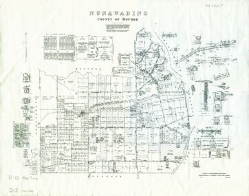
 Whitehorse Historical Society Inc.
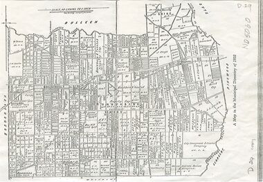
Map, Shire of Nunawading, 1892
Map of the Shire of Nunawading in the Municipal Directory of 1892e of NunawadingPhotocopy of a map of the Shirew of Nunawading in the Municipal Directory of 1892 showing land owners.Map of the Shire of Nunawading in the Municipal Directory of 1892e of Nunawadingmaps, shire of nunawading -
Whitehorse Historical Society Inc.
Map, City of Whitehorse, 1/03/1995 12:00:00 AM
Map of City of Whitehorse prepared by Richard Meloni showing roads, railways, creeks.Map of City of Whitehorse prepared by Richard Meloni showing roads, railways, creeks.Map of City of Whitehorse prepared by Richard Meloni showing roads, railways, creeks.blackburn, nunawading, blackburn south, mitcham, vermont, vermont south, blackburn north, forest hill, burwood east, city of whitehorse -
Whitehorse Historical Society Inc.
Map, Parish of Bulleen, 1892
Copy of map of the Parish of BulleenCopy of map of the Parish of Bulleen together with North-East portion of the Parish of Nunawading.Copy of map of the Parish of Bulleenmaps, parish of bulleen, parish of nunawading -
Whitehorse Historical Society Inc.
Map, Elmore Houses, 1/08/1993 12:00:00 AM
Elmore Houses - Blackburn Lake Walk [map by] Ken Green. August 1993.Elmore Houses - Blackburn Lake Walk [map by] Ken Green. August 1993.Elmore Houses - Blackburn Lake Walk [map by] Ken Green. August 1993.blackburn, green, ken, elmore houses, elmore, algernon john -
Whitehorse Historical Society Inc.
Map, Aboriginal sites in the City of Doncaster-Templestowe, 1/03/1991 12:00:00 AM
Map of City of Doncaster and Templestowe.Map of City of Doncaster and Templestowe showing location of stone artefacts and scarred trees.Map of City of Doncaster and Templestowe. aborigines, city of doncaster and templestowe -
 Bacchus Marsh & District Historical Society
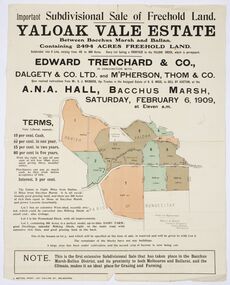
Map, Edward Trenchard & Co, Important Subdivisional Sale of Freehold Land Yaloak Vale Estate
A land sales map and advertisementLand sales advertising poster with map indicating specific lots of land for sale.A land sales map and advertisementimportant subdivisional sale of freehold land yaloak vale estate, land sales -
Greensborough Historical Society
Map, Victoria: Yan Yean, prep. by Australian Section of Imperial General Staff, 1935
Part of 1:63,360 series of survey mapsColour copy from original. Scale: 1: 63,360 (1 inch to 1 mile) 2 copiesRev. 1930 by Australian Survey Corps using RAAF Air Photos. yan yean -
 Whitehorse Historical Society Inc.
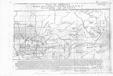
Map, Plan of locality, 1855-60?
'Plan of locality, showing the whole line of route to the district from Melbourne by way of Nunawading and Bulleen. 2,000 acres for sale... Thomas Ham, Land Agent [ 1855 - 60?]nunawading, bulleen, barkers track, land sales -
Whitehorse Historical Society Inc.
Map, Shire of Blackburn and Mitcham, 1928
Combination of two sheets of detailed map.Combination of two sheets of detailed map. Many subdivisions shown in details with lot numbers.Combination of two sheets of detailed map. maps, shire of blackburn and mitcham -
Whitehorse Historical Society Inc.
Map, City of Nunawading, n.d
Map of the City of Nunawading with streets and railway stations namedMap of the City of Nunawading with streets and railway stations named Scale 1 mile = 3.75 inMap of the City of Nunawading with streets and railway stations named city of nunawading, maps -
Whitehorse Historical Society Inc.
Map, City of Nunawading, c1980
Map of the City of Nunawading with list and location of 47 schools.Map of the City of Nunawading with list and location of 47 schools. Scale 1 mile = 3.75 inMap of the City of Nunawading with list and location of 47 schools. city of nunawading, maps, schools -
Whitehorse Historical Society Inc.
Map, City of Whitehorse, 2001
Key map of City of Whitehorse, showing parks and reserves, council and community facilities and services.Key map of City of Whitehorse, showing parks and reserves, council and community facilities and services.Key map of City of Whitehorse, showing parks and reserves, council and community facilities and services.libraries, child care centres, parks and reserves, senior citizens centres, maternal and child health centres, city of whitehorse -
 Whitehorse Historical Society Inc.
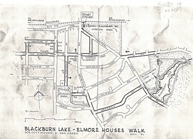
Map, Blackburn Lake - Elmore houses walk, 1/11/1991
Map of Blackburn outlining a walk through the lake.Map of Blackburn outlining a walk through the lake. The route includes four Elmore houses.Map of Blackburn outlining a walk through the lake.maps, blackburn lake sanctuary, the avenue, blackburn, laburnum street, main street, gardenia street, blackburn road, gordon crescent -
Whitehorse Historical Society Inc.
Map, City of Nunawading, 1980?
Map of the City of Nunawading showing streets to south of Burwood Highway and east of Springvale Road.Map of the City of Nunawading showing streets to south of Burwood Highway and east of Springvale Road.Map of the City of Nunawading showing streets to south of Burwood Highway and east of Springvale Road.city of nunawading, historical -
Whitehorse Historical Society Inc.
Map, City of Nunawading, 21/10/1994 12:00:00 AM
Map showing streets in the City of Nunawading, prep. by M. Day Scale 1:15,000Map showing streets in the City of Nunawading, prep. by M. Day Scale 1:15,000Map showing streets in the City of Nunawading, prep. by M. Day Scale 1:15,000city of nunawading, maps -
Creswick Campus Historical Collection - University of Melbourne
Map, 1923
Includes detail of Plantation layout and plantings at the time and later plantings (1930's) in pencil.Map -
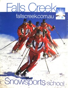 Falls Creek Historical Society
Booklet - Falls Creek Snowsports School Information and Trail map 2002
Part of yearly marketing and information material promoting the Falls Creek Ski School. This publication includes detailed information about the Falls Creek Snowsport School Program for 2002. An introduction by the School Director, Benny Pregenzer states "Our motto is improving our guests skiing and boarding in a fun and safe environment. The most important facets of a good instructor are patience and empathy. These are qualities that our instructors display in every lesson and together with successful teaching methods, will ensure you experience fast improvement. Our instructors are carefully selected from Australia and all over the world to provide the highest quality service possible. Have a great holiday and see you on the slopes." The brochure bears the logo of Nursing Australia, proud sponsors of the Falls Creek Snowsport School.This item is important because it documents seasonal activities at Falls Creek Snowsport School in 2002.A glossy booklet featuring images and information about programs to be offered at Falls Creek in the 2002 winter season. The front cover features a group of downhill skiers while the back cover is illustrated with an image of a female snowboarder. Coloured images are included throughout the booklet. The centre page includes a map of trails at Falls Creek.On front cover Falls Creek and the resort Logo fallscreek.com.au Snowsport Schoolfalls creek marketing, falls creek ski academy, falls creek race club, falls creek snowsport school. -
 Bacchus Marsh & District Historical Society
Map, Plan of Survey of Part of Crown Allotment 9, Parish of Korkuperrimul, 1890
This map documents a transfer of an allotment of land in Clarke Street Bacchus Marsh in 1890. Clarke Street is located on the eastern side of Bacchus Marsh not far from Main Street and Crook Street. It is now known as Candeloro Street. The map indicates J. Booth as the owner of the land and H. Simpson as the occupier. Next to this allotment is a an allotment of land owned by J. Elmore,Single page map showing Crown allotment 9, Parish of Korkuperrimul, County of Bourke. Scale 100 feet to inch. Part of a set of maps which are pasted into a bound volume containing 76 maps or plans in total. High resolution digital image stored on BMDHS computer network. At bottom of map: I hereby certify that I have made this survey expressly for the purpose of an application under the Transfer of Land Statute that this plan is correct. Barry B???, Lic. Surveyor, 16.10.90bacchus marsh victoria maps, clarke street bacchus marsh maps -
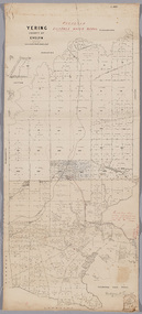 Yarra Ranges Regional Museum
Map, District of Yering, 1 Dec 1885
Canvas backed paper map of District of Yering, Country of Evelyn, showing proposed waterworks for township of Lilydale. Signed by Hodgson & Smith, water supply engineers. Proposed waterworks for the township of Lilydale. Signed by Hodgson & Smith, water supply engineers. Proposed water main shown with of reservoir etc. Canvas backed paper map of District of Yering, Country of Evelyn, showing proposed waterworks for township of Lilydale. Signed by Hodgson & Smith, water supply engineers. Proposed waterworks for the township of Lilydale. Signed by Hodgson & Smith, water supply engineers. Proposed water main shown with of reservoir etc. evelyn, lilydale, waterworks and irrigation -
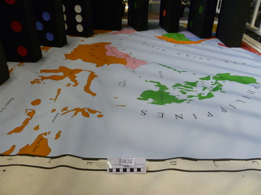 National Vietnam Veterans Museum (NVVM)
Map, Flawed Theory, 2009
Large PVC 1965 political map of South East Asia with nine large dominoes attached'Asia South East Political 1965'domino theory, 3rar, jones, geoffrey r -
 Whitehorse Historical Society Inc.
Map, Nunawading, 1970
Reprint of original map of Shire of NunawadingReprint of original map of Shire of Nunawading with various update but mostly showing 19th century landholders.Reprint of original map of Shire of Nunawadingmaps, shire of nunawading -
Whitehorse Historical Society Inc.
Map, State Electoral Districts, 1937
Map showing [Victorian] State Electoral Districts, Metropolitan, 1937.Map showing [Victorian] State Electoral Districts, Metropolitan, 1937. Scale: 40 chains to the inch.Map showing [Victorian] State Electoral Districts, Metropolitan, 1937.electoral boundaries, melbourne, elections -
Whitehorse Historical Society Inc.
Map, City of Nunawading, n.d
Map of the City of Nunawading with a list and locations of 48 schools.Map of the City of Nunawading with a list and locations of 48 schools. Scale: 1 mile = 3.75 inches.Map of the City of Nunawading with a list and locations of 48 schools. city of nunawading, schools -
Whitehorse Historical Society Inc.
Map, City of Nunawading, n.d
Map of the City of Nunawading with a list and locations of 49 schools.Map of the City of Nunawading with a list and locations of 49 schools. Scale: 1 mile = 3.75 inchesMap of the City of Nunawading with a list and locations of 49 schools. schools, city of nunawading