Showing 2075 items
matching parish
-
 Bendigo Historical Society Inc.
Map - ELLESMERE, Circa 1878
Map: Ellesmere, County of Bendigo. Parish plan (number 255 in map cupboard 1)map, bendigo, parish plan, ellesmere -
Bendigo Historical Society Inc.
Map - MUSKERRY, 23/01/1888
Map: Muskerry , County of Rodney. Parish plan. ( number 251 in Map Cupboard 1)map, rodney, parish plan, muskerry -
Bendigo Historical Society Inc.
Map - MUSKERRY, 23/01/1888
Map: Muskerry, County of Bendigo. Parish plan ( number 250 in Map Cupboard 1)map, bendigo, parish plan, muskerry -
Bendigo Historical Society Inc.
Map - NOLAN, 5/03/1888
Map: Nolan, County of Bendigo. Parish plan ( number 249 in Map Cupboard 1)map, bendigo, parish plan, nolan -
Bendigo Historical Society Inc.
Map - MINTO, 10/01/1884
Map: Minto, County of Bendigo. Parish plan. ( number 248 in Map Cupboard 1).map, bendigo, parish plan, minto -
Bendigo Historical Society Inc.
Map - TARNAGULLA, 8/08/1912
Map: Tarnagulla sheet 2. Parish plan ( number 241 in Map Cupboard 1)map, talbot, parish plan, tarnagulla -
Bendigo Historical Society Inc.
Map - GOORNONG, 19/04/1873
Map: Goornong, Hand draughted parish plan ( number 238 in Map Cupboard 1)map, bendigo, parish plan, goornong -
Bendigo Historical Society Inc.
Map - DIGGORRA, 26/04/1880
Map: Diggorra, County of Bendigo. Parish plan ( number 237 in Map Cupboard 1)map, bendigo, parish plan, diggorra -
Bendigo Historical Society Inc.
Map - EGERTON, 13/05/1879
Map: Egerton, County of Bendigo. Parish plan ( number 236 in Map Cupboard 1)map, bendigo, parish plan, egerton -
Bendigo Historical Society Inc.
Map - BENDIGO SHEET 4, Circa 1940's
Map: Bendigo sheet 4. Parish plan ( number 210 in Map Cupboard 1)map, bendigo, parish plan, bendigo -
Bendigo Historical Society Inc.
Map - TARNAGULLA SHEET 3, No date visible
Map: Tarnagulla Sheet 3. Parish plan (number 308 in map cupboard 1)map, parish plan, tarnagulla -
Bendigo Historical Society Inc.
Map - TARNAGULLA SHEET 2, No date visible
Map: Tarnagulla Sheet 2. Parish plan (number 307 in map cupboard 1)map, parish plan, tarnagulla -
Bendigo Historical Society Inc.
Map - TARNAGULLA SHEET 4, 25/11/1926
Map: Tarnagulla Sheet 4. Parish plan (number 306 in map cupboard 1)map, parish plan, tarnagulla -
Bendigo Historical Society Inc.
Map - DERBY, No date visible
Map: Derby. Hand draughted parish plan (number 303 in map cupboard 1)map, bendigo, parish plan, derby -
Bendigo Historical Society Inc.
Map - EPPALOCK, COUNTY OF BENDIGO MAP, 3/11/1882
Map: Eppalock, County of Bendigo. Parish plan (number 302 in map cupboard 1)map, bendigo, parish plan, eppalock -
Bendigo Historical Society Inc.
Map - NEILBOROUGH, 15/10/1877
Map: Neilborough, County of Bendigo. Parish plan (number 301 in map cupboard 1)map, bendigo, parish plan, neilborough, elysian flat -
Bendigo Historical Society Inc.
Map - LEICHARDT, Circa 1870's
Map: Leichardt, Hand draughted parish plan ( number 300 in map cupboard 1 )map, bendigo, parish plan, leichardt -
Bendigo Historical Society Inc.
Map - HAYANMI, 16/05/1879
Map: Hayanmi, County of Bendigo. Parish plan (number 294 in map cupboard 1)map, bendigo, parish plan, hayanmi -
Bendigo Historical Society Inc.
Map - REDCASTLE, 15/10/1878
Map: Redcastle, County of Rodney. Parish plan. (number 293 in map cupboard 1)map, rodney, parish plan, redcastle -
Bendigo Historical Society Inc.
Map - WESTON RESURVEY, June 20th 1875
Map: Weston, Resurvey.Hand draughted Parish plan (number 292 in map cupboard 1)map, parish plan, weston -
Bendigo Historical Society Inc.
Map - STRATHFIELDSAYE, 25/06/1877
Map: Strathfieldsaye, County of Bendigo. Parish plan (number 291 in map cupboard 1)map, bendigo, parish plan, strathfieldsaye -
Bendigo Historical Society Inc.
Map - RUNNYMEDE, 2/05/1895
Map: Runnymede, County of Rodney. Parish plan (number 285 in map cupboard 1)map, rodney, parish plan, runnymede, county of rodney -
Bendigo Historical Society Inc.
Map - NOLAN, 5/03/1888
Map: Nolan, County of Bendigo. Parish plan (number 284 in map cupboard 1)map, bendigo, parish plan, nolan -
Bendigo Historical Society Inc.
Map - MINTO, /01/1884
Map: Minto, County of Bendigo. Parish plan (number 283 in map cupboard 1)map, bendigo, parish plan, minto -
Bendigo Historical Society Inc.
Map - PANNOOMILLOO, 21/06/1882
Map: Pannoomilloo, County of Bendigo. Parish plan (number 282 in map cupboard 1)map, bendigo, parish plan, pannoomilloo -
Whitehorse Historical Society Inc.
Map, Plan, 1939
Plan of subdivision, part of crown portion 83A and 83, Parish of Nunawading, County of BourkePlan of subdivision, part of crown portion 83A and 83, Parish of Nunawading, County of BourkePlan of subdivision, part of crown portion 83A and 83, Parish of Nunawading, County of Bourkestreet names, parish of nunawading, station street, blackburn, railway road, blackburn, vine street, blackburn, south parade, blackburn, laburnum street, blackburn, main street, blackburn, gardenia street, blackburn, the avenue, blackburn, fuschia street, blackburn, linum street, blackburn -
Bendigo Historical Society Inc.
Book - LYDIA CHANCELLOR COLLECTION: HISTORY OF THE PARISH CHURCH OF ST PAUL 'THE FIRST HUNDRED YEARS', 1988
LYDIA CHANCELLOR COLLECTION: HISTORY OF THE PARISH CHURCH OF ST PAUL 'THE FIRST HUNDRED YEARS'bendigo, history, bendigo churches -
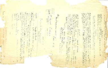 Beechworth Honey Archive
Hand-Written Copy of Particulars and Conditions of Sale of Land May 1922
This item consists of two pages. Page One: Hand-written copy of a Particulars and Conditions of Sale of Land for a piece of land in Moira county (East of Goulburn River, South of Murray River, West of Ovens River). Also inculded is a hand-written copy of a Particulars and Conditions of a Contract of Sale; Frank L. Frost is selling land to Bridget Ellen Ryan. Takes place in May 1922. Copy of Transfer of Land Title. Purchase price £478.11.3 Page Two: A list of Parish, Shire and County locations. Both pages written with black ink on paper. hand written, hand-written, particulars, conditions, sale, land, title, parish, shire, county, ryan, frost, beekeeper, beechworth honey -
Bendigo Historical Society Inc.
Map - CAMPBELL COLLECTION: BENDIGO & DISTRICT MAPS, 22-3 29
Map. Marong, Parishes of Marong, Lockwood and Mandurang. Scale 20 chains to an inch. Total area 5106 acres. Crusoe Reservoir on right. Compiled in W.P.B. from Field Survey and Parish Plans (number 373 in map cupboard 1)G.W.Lmap, bendigo, allotments -
Bendigo Historical Society Inc.
Map - CAMPBELL COLLECTION: BENDIGO AND DISTRICT MAPS
Map. Marong, Parishes of Marong, Lockwood and Mandurang. Scale 20 chains to an inch. Total 5106 acres. Compiled in W.P.B. from Field Survey and Parish Plans. Crusoe Reservoir to the right of map. (number 362 in map cupboard 1)map, bendigo, parish plan