Showing 2472 items matching " township"
-
 Lakes Entrance Historical Society
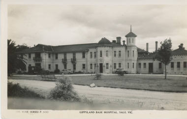
Postcard, Rose Series, The Gippsland Base Hospital Sale Victoria, 1930 c
Black and white postcard of Gippsland Base Hospital showing extensive double storeyed building in front of a ground floor building. Two cars and an ambulance parked outside main building Sale Victoriahospital, township -
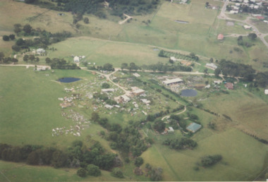
 Lakes Entrance Historical Society
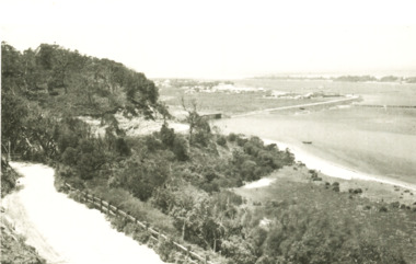
Postcard - Lakes Entrance viewed from Jemmys Point, Rose Series, 1925 c
Post and rail fence beside highway and no vegetation on sand dunes eastern part of Cunninghame ArmBlack and white postcard showing view of Cunninghame Arm from Jemmys Point, gravel Princes Highway, North Arm bridge and end of town Lakes Entrance VictoriaNearing Lakes Entrance on the Princes Highwaytownship, waterways -
 Lakes Entrance Historical Society
Album, M Fish, East Gippsland Album
Images copied from postcards, publications and other sources. S.S. Wyrallah S.S. Murray, S.S. Dargo, S.S. Gippsland, Dredge Wombat. Campbelltown cottages, Excellent photographic record of the building of the EntranceBlue covered album containing 122 copies of postcards of East Gippsland Victoriatownship, ships and shipping -
Lakes Entrance Historical Society
Book, Synan, Peter, Units of the Royal Australian Air Force. A concise History Volume 7 - Maintenance Units, 1994
A history of the town of Sale, Victoria, Australia from 1839 to 1993. Includes index.With every best wish Peter Synantownship, government -
 Lakes Entrance Historical Society
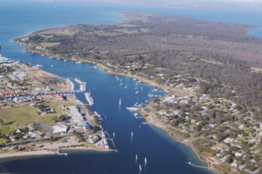
Photograph - McMillan Strait, 2005 c
Colour aerial photograph of McMillan Strait between Paynesville on left and Raymond Island on right on Gippsland Lakes Victoriaaerial photograph, township -
 Lakes Entrance Historical Society
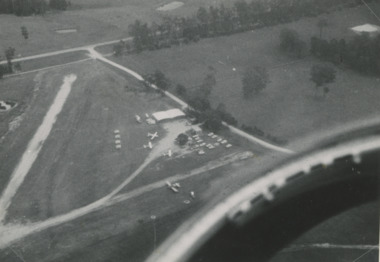
Photograph - Campell's Airfield Lakes Entrance, Lakes Post Newspaper, 1/01/1993 12:00:00 AM
DCNR Crews from Bairnsdale Swifts Creek and Nowa Nowa training at Campbell's AirfieldBlack and white aerial photograph of Campbell's Airfield Colquhoun Road showing planes and vehicles near hanger Lakes Entrance Victoriaaerial photograph, township -
 Lakes Entrance Historical Society
Photograph - Lakes Entrance, 1993c
Red brick house on right O'DonnellsColour aerial photograph of Blair Road showing first few dwellings of housing estate Tarra Landing in background Lakes Entrance Victoriaaerial photograph, township -
 Lakes Entrance Historical Society
Photograph - Lakes Entrance, 1952c
Colour photograph of town from Myers Street looking west showing footbridge, Cunninghamme Arm and North Arm Lakes Entrance Victoriaaerial photograph, township -
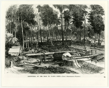 Marysville & District Historical Society
Work on paper (item) - Print of wood engraving, Frederick Grosse et al, Marysville, on the road to Wood's Point, 27-11-1866
A copy of an early wood engraving taken from a photograph of the township of Marysville in Victoria.A copy of an early wood engraving taken from a photograph of the township of Marysville in Victoria. The Yarra Track is the former name of the gold fields road from Healesville to the Woods Point and Jordan Goldfields in Victoria.victoria, frederick grosse, albert charles cooke, thomas waters, wood engraving, marysville, wood's point road -
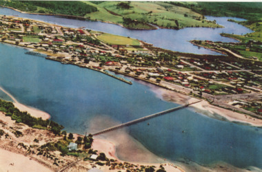
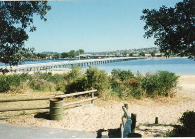 Lakes Entrance Historical Society
Photograph - Footbridge, 1999c
This photo taken from south side (looking towards township on northern side)Colored photograph of the footbridge over the Cunninghame Arm, taken from the path on the southern shore. It shows sand, scrub, treated pine fences and rubbish bin, town in the distance on northern shore. Lakes Entrance Victoriawaterfront, topography, bridges -
 Kiewa Valley Historical Society
Papers - Hollonds' Family and their memories, 2013
The Hollonds' family were original settlers in the Kiewa Valley at Mulagong. Their descendants owned land in Tawonga, Tawonga South and between the East and West of the Kiewa river. Hollonds had a cattle run on Mt Fainter which was later given to the Hicks family.Members of the Hollonds family lived, worked and married in the Kiewa Valley. These papers describe the connection to the families and the Kiewa Valley.Typed papers donated by the Hollonds' family covering: The Hollonds Family History, Cattlemen, 'Snowy' Miller, Mrs Hollonds' Boarding house, SEC Depot at Tawonga, building of Bogong Township, Early Scenes on the Kiewa Scheme.hollonds family, tawonga station, cattlemen, mt beauty land, tawonga boarding house -
 Bendigo Military Museum
Photograph - PHOTOGRAPH, FRAMED
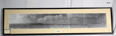
Tobruk panorama. Black plastic frame, glass front, white cardboard backing, black & white photograph with cream border. Photo in 5 sections showing Tobruk township & surrounding landscape of desert & military vehicles. LHS bottom front: Donation info sticker Centre front: Tobruk sticker Blue sticker on backing: Bendigo City Framersphotograpy - photographs, frame accessories, tobruk -
Federation University Historical Collection
Map, Town of Buninyong, 1927, 09/1927
The date of this map is September 1927 revised from the original 1910 map. Buninyong was created a district on 09 July 1858, proclaimed a Shire on 16 February 1864, and the Buninyong Borough united on 01 October 1915.Township plan of the Town of Buninyong showing government roads and crown allotments. Earlier detail pencilled on (commercial buildings, etc) appears to be from an 1850 survey. Scale: 4 chains to 1 inch (1:3168)buninyong, map, buninyong botanical gardens, tannery dam, buninyong reservoir, chapel school, rev. hastie -
Linton and District Historical Society Inc
Mortgage document, Mortgage agreements, 1863 and 1868 : William Hugill and Henry Franks
Value of the mortgage was £500. Henry Franks appears to have lent William Hugill the money to purchase the land from him, and to have extended the agreement in 1868. See aslo conveyance document connected to this mortgage agreement: Registration no. 2023-47.A3 photocopy of mortgage agreements drawn up between William Hugill and Henry Franks, in connection with the sale/purchase of Allotment 15, Section 1, Township of Linton. (Current address 64 Sussex Street, Linton.)henry franks, william hugill, mortgage agreements, allotment 15 section 1 township of linton, 64 sussex street linton -
 Clunes Museum
Photograph, KODAK, 1999
VIEW OF POWDER MAGAZINE USED IN MINING DAYS TO STORE EXPLOSIVES. BUILDING MATERIALS SOLID BRICKCOLOURED PRINT PHOTOGRAPH OF POWDER MAGAZINE EXTERIOR. SITUATED IN A PADDOCK ON SMEATON ROAD APPROX. 2 KM. FROM TOWNSHIP ON LEFT HAND SIDE. LEAFLESS TREE IN FOREGROUND - FALLEN TREE BESIDE IT EASTERN ASPECT.local history, photography, photographs, mining -
 Bendigo Historical Society Inc.
Map - CAMPBELL COLLECTION: BENDIGO AND DISTRICT MAPS, 1959
Map. Huntly, County of Bendigo, Neilborough, Bagshot, Nerring, Wellsford, Sandhurst. Township of Huntly. By Authority A.C. Brooks, Government Printer Melbourne. Drawn and reproduced at the Department of Lands and Survey, Melbourne, 1958. Price 5/-.A.C. Brooks, Government Printermap, bendigo, allotments, huntly -
 Bacchus Marsh & District Historical Society
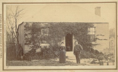
Photograph, Cottage Bacchus Marsh 1883
The precise location of this house and the identity of the two people in the picture has not been established. It is possible it is a house within the township area of Bacchus Marsh. The image only includes the house and the garden area and does not depict any surrounding farm land or farmyard buildings indicating a probable township location.Small sepia unframed photograph on card with gold border framing photograph. Housed in the album, 'Photographs of Bacchus Marsh and District in 1883 by Stevenson and McNicoll'. The image depicts a house with a man and a woman standing in front of it. The house has a well-established creeper present across much of the front of the house indicating it had been occupied for some time when this photograph was taken.On the front: Stevenson & McNicoll. Photo. 108 Elizabeth St. Melbourne. COPIES CAN BE OBTAINED AT ANY TIME. On the back: LIGHT & TRUTH inscribed on a banner surmounted by a representation of the rising sun. Copies of this Portrait can be had at any time by sending the Name and Post Office Money Order or Stamps for the amount of order to STEVENSON & McNICOLL LATE BENSON & STEVENSON, Photographers. 108 Elizabeth Street, MELBOURNE stevenson and mcnicoll 1883 photographs of bacchus marsh and district, houses bacchus marsh -
 Greensborough Historical Society
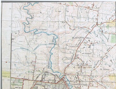
Map, John Monash, 1913 Map of Greensborough, 1913
1913 Map of Greensborough, possibly by John Monash. This map shows the area to the north of the township.Map, colour.greensborough - maps, 1913 -
 Greensborough Historical Society
Article, Printer Unknown, Greensborough, 1840o
Details the history of the current Greensborough township. It also mentions the early settlement of Kangaroo Point.Mentions early settlers such as William Poulter, James Chapman, James Mann and Edwin Willis Magger (Maygar).2 page printed document outlining the activities and motives of Edward Bernard Green, an early owner of the area of land that became Greensborough.Pencilled words on front page. greensborough, kangaroo point, edward green, poulter, mann, chapman, magger, mayger, melbourne to sydney mail contract -
 Halls Gap & Grampians Historical Society
Photograph - B/W, C 1878-1888
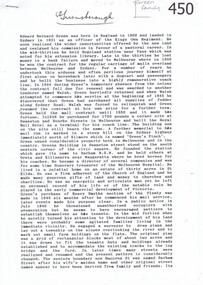
This school was moved to Heatherlie Township from Darra in 1888. Closed in 1890 and moved to BeulahTeacher and students outside School House Historical Places Branch,education, schools, heatherlie -
 Tatura Irrigation & Wartime Camps Museum
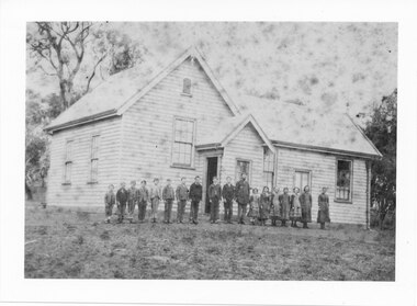
Book, Kyabram, 1965
Written history of the township of Kyabram, covering squatters, the reform movement, churches, hospitals etc.Red hard cover. Cover design by Anne Bossence. Dust jacket green, white and brown. Title and author in black print. Drawing of a water wheel in green and brown. Back cover whitebossence w, kyabram, kyabram reform movement, kyabram churches, kyabram hospitals, kyabram squatters -
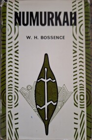 Tatura Irrigation & Wartime Camps Museum
Book, Numurkah, 1965
Written history of the township of Numurkah, covering squatters, the aboriginals, churches, hospitals, railways etc.Black hard cover. Cover design by Anne Bossence. Dust jacket green, white and brown. Title and author in black print. Sketch on front is of an aboriginal drawing depicting a leaf with an animal on it in green. Back cover whitebossence w, numurkah, numurkah squatters, numurkah aboriginals, numurkah churches, numurkah hospitals -
Stawell Historical Society Inc
Map, Plan of Division Line between Ararat and Stawell Shires 1877, 1877
Grampians Halls Gap Black Range Stawell Shire Ararat Shire Crowlands TownshipVery Large Map Printed on Linen with Table of bearingsExamined by H.C. Malcolm 28.12.77 Traced By D.H. Meike 28.12.77survey -
 Phillip Island and District Historical Society Inc.
Photographs/Slides, Laurie Dixon, 1960's
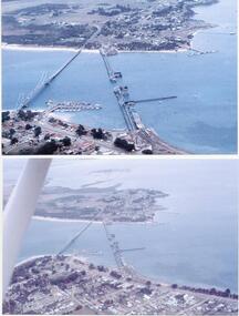
Four of a collection of slides taken by Laurie Dixon. (Scanned by E Alexander) The new bridge was built in 1968.Four coloured photographs scanned from slides. Three aerial views. 273-01. Aerial view of the old and new bridges and Newhaven, San Remo and Churchill Island - extra close up of same photo. 273-02. Aerial view of the old and new bridges looking towards Cape Woolamai on the top right. 273-03. Aerial view of the Cowes Pier and township - extra close up of same photo. 273-04. Looking down the Cowes Pier towards the township with Isle of Wight Hotel in the background.273-03. Inscription on the slide: Cowes from the air Jan 1968.phillip island suspension bridge, two bridges phillip island, san remo, newhaven, laurie dixon, cowes pier, cowes pier phillip island -
 Kiewa Valley Historical Society
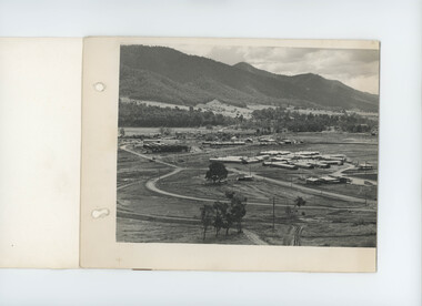
Photo - black & white - Mt Beauty Township, April 1948
Panorama of 'General View of Mt Beauty Township' SECV black & white photo dated 22 April 1948. This is the first of three photos that fold out and join to complete the panorama. (Note: the other two photos not included) -
 Kiewa Valley Historical Society
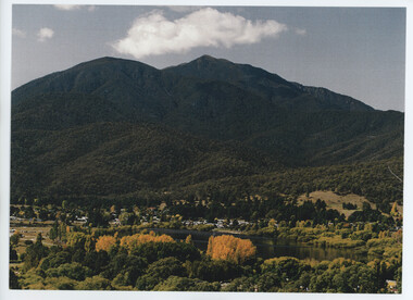
Photos - Mt Beauty Township and 'The Chalet'
Mt Beauty was built by the SECV to house the workers working on the Kiewa Hydro Electric Scheme.A. Colored photo of Mt Beauty Township in Autumn with Mount Bogong in the background. B. A long black and white photo attached to white cardboard with the title 'Staff accommodation Mt Beauty 1948-49' written below the photo.On the back in pencil 'Building "The Chalet" 1948-49'the chalet mt beauty -
 Bendigo Historical Society Inc.
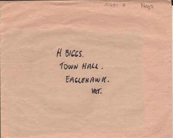
Negative - ALBERT RICHARDSON COLLECTION: EAGLEHAWK TOWNSHIP NEGATIVES
Envelope containing two negatives: on outside of envelope 'H. Biggs, Town Hall, Eaglehawk, Vict' on back 2 negatives, 1 township of Eaglehawk, 2. View from behind Eaglehawk Town Hall. Negatives not scanned.bendigo, streetscape, eaglehawk -
 Bendigo Historical Society Inc.
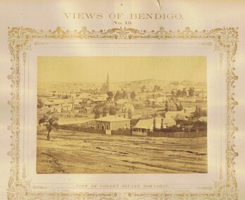
Photograph - VIEWS OF BENDIGO: GOLDEN SQUARE TOWNSHIP, c. 1870's
Photograph No. 19. Sepia photograph of view of Golden Square township. Church in centre back of view. Printed below photograph: Welch Type, Forbes & Holmes, Agents. Written on front MP148 (Two Copies) Nicholas CaireN J Caireplace, landscape view, golden square -
 Bendigo Historical Society Inc.
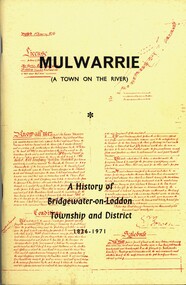
Book - MULWARRIE A TOWN ON THE RIVER A HISTORY OF BRIDGWATER-0N-LODDON TOWNSHIP AND DISTRICT 1836-1971, 1971
'Mulwarrie' (A Town on the River). A History of Bridgewater-on-Loddon Township and District 1836-1971. Publisher: Jim Lowden Printing, Kilmore 3601. 80 pages. Photographs & illustrations. Bridgewater-on -Loddon History. Inscriptions: Bendigo Historical Society.Back to Bridgewater Committee 1971history, bridgewater -
 Bendigo Historical Society Inc.
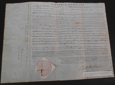
Document - WES HARRY COLLECTION: SALE OF LAND ALLOTMENT 20 IN TOWNSHIP OF WHITE HILLS DATED 5TH NOVEMBER 1855, 1855
Land Sale Agreement dtaed 5th November 1855 signed and selaed by Charles Hotham Allotment 20 Section 10 Township of White Hills Sold to George Souter Butter for the sum of six pounds and fifteen shillings