Showing 8358 items matching "bridges"
-
 Mt Dandenong & District Historical Society Inc.
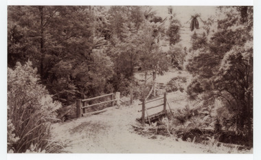
Photograph, The Crescent Bridge, Sassafras
Photograph taken at the bottom of the hill on 'The Crescent' at Sassafras where the Crescent Bridge crosses the Sassafras Creek.Black and white cop of a photograph showing a bridge crossing an unmade road over creek. Bush in background.sassafras, sassafras creek, crescent bridge, bridge, the crescent, bush, tree ferns -
 Federation University Historical Collection
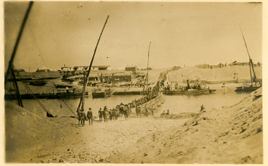
Postcard, Crossing the Suez via Pontoon Bridge, 1915
During WWI some AIF soldiers were located at the Suez in Egypt.Postcard with sepia photograph of Suez canal with soldiers crossing a pontoon bridge.Verso: "POST CARD" at centre top, "Correspondence" LHS top and "Address" RHS top "No 2" in black ink handwritten on top LHS corner. Handwriting blacked out on centre. "crossing the Suez via Pontoon Bridge" in pencilsuez, soldiers, wwi, world war one, canal, pontoon bridge, holmes, anzac -
 Glenelg Shire Council Cultural Collection
Photograph - Photograph - Bridge Construction, 29/05/1957
Port of Portland Authority ArchivesFront: Back- 'Bridgewater road Bridge (otway street) 29/5/57' - pencilport of portland -
 Linton and District Historical Society Inc
Photograph, Dilapidated bridge over Springdallah Creek, Happy Valley/Piggoreet, 2010
This bridge was built in the 1880s. By the 1980s it was in a dilapidated condition and was replaced. The old bridge was further damaged by storms and flooding in November 2010 and January 2011. (The newer bridge was completely washed away when the Springdallah Creek flooded in January 2011.) In 2025, little remains of the old bridge.Two colour photographs of a trestle bridge spanning Springdallah Creek, Linton-Piggoreet Road. The two photographs have been sticky-taped together to form one panoramic image.trestle bridges, old springdallah bridge -
 City of Whittlesea
Photograph - Photographs - Bridges, Moses Thomas bridge over the Plenty River 1970, 1970
... bridges ...Bluestone bridge across the Plenty River, Mernda. Commissioned by Moses Thomas, Secretary Morang District Road Board 1867bridges, moses thomas, mernda, bridge inn road -
 Federation University Historical Collection
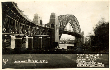
Postcard, Kodak, Sydney Harbour Bridge, c1949, 13/10/1949
Postcard written by Frank Wright to a friend, W. Snelling in London. Frank Wright was a renown resident of Smeaton, where he was born. He lived at Laura Villa, and attended Smeaton State School. His father William was a gold miner and his mother's name was Sarah. Their family won many singing and instrumental awards. Frank was tutored by Percy Code and was awarded a gold medal for the highest marks in the ALCM examinations in the British Colonies at the age of seventeen years. He became the Australian Open Cornet Champion by the age of eighteen. A year later, Frank conducted the City of Ballarat Band, and later the Ballarat Soldiers’ Memorial Band. He formed the Frank Wright Frisco Band and Frank Wright and his Coliseum Orchestra. These bands won many South Street awards, and Frank as conductor won many awards in the Australian Band Championship contest. In 1933 Frank Wright sailed to England to conduct the famous St Hilda’s Band and was later appointed Musical Director of the London County Council, where he organized many amazing concerts in parks, in and around the London district. He was made Professor of Brass and Military Band Scoring and conducted at the Guildhall of Music and Drama. Frank was often invited to adjudicate Brass Band Championships around Europe, in Australia, including South Street and in New Zealand. The Frank Wright Medal at the Royal South Street competition is awarded to an individual recognized as making an outstanding contribution to brass music in Australia.Black and white photograph of the Sydney Harbour Bridge. A small section of the city and water can be seen beneath the arched span of the bridge.Written in white on front - 660.B, Harbour Bridge, Sydney., Height-Top arch - 437 ft.,Width 159 ft. 11 3/4 in., Footways 10 ft. ea., Roadway 57 ft., Four Electric Rail Tracks., Length of span 1650 ft. Handwritten on back - Message to W. Snelling in London from Frank Wrightfrank wright, cornet, conductor, sydney harbour bridge -
 Ballarat Heritage Services
Photograph - Photograph - Colour, The Edna Walling Bridge at Locarno Spring in the Hepburn Springs Reserve, 2020, 12/12/2020
The Hepburn Springs Progress Association invited Edna Walling the the Hepburn Springs Reserve, and sandstone paths and bridges resulted. In 1934 there was a proposal to spend 2,000 to 3,000 poinds at the Hepburn Springs Reserve, with a govenrment loan suggested. Colour photograph of the stone bridge at Locarno Spring in the Hepburn Springs Reserve.hepburn springs, locarno, mineral water, hepburn springs reserve, locarno spring, edna walling -
 Phillip Island and District Historical Society Inc.
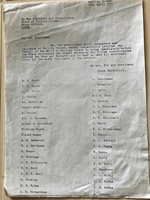
Document, Petition for bridge between Phillip Island and San Remo 1937
On 29 November 1940, a suspension bridge opened between San Remo on the mainland and with Newhaven on Phillip Island. The 540 metre bridge had two lanes but no footpaths, instead having six pedestrian refuges. The main span was 168 metres long. The cables had previously been used on a bridge on Sydney's North Shore. Because of weight restrictions, tourist coaches had to offload their passengers. [Wikipedia]HistoricalFoolscap size photocopy of a petition to Shire of Phillip Island for a bridge to Phillip Island in 1937. Signed by 42 local residents and ratepayers.first phillip island bridge to san remo, phillip island suspension bridge, petition, odlum, ockleford, regos, mcguigan, west, mcfee, richardson, underdown, mcmaster, cleeland, neely, leeson, saunders, scott, brown, hislop, donnellan, rackham, findlay, anderson -
 Lakes Entrance Historical Society
Photograph, 1947
... Bridges ...1/02/1947 12:00:00 AMBlack and white photograph of the Princes Highway bridge over Bunga Creek showing the sharp bend in the road as it crosses the creek east of Lakes Entrance Victoriabridges, transport, roads and streets -
 Lakes Entrance Historical Society
Photograph - Bullock Island, 1930c
... Bridges ...Black and white photograph of Bullock Island, showing sparse vegetation on island, low foot bridge to island, reedy vegetation in foreground. Lakes Entrance Victoria topography, islands, bridges -
 Lakes Entrance Historical Society
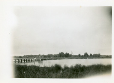
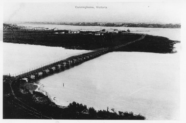
Photograph - Norm Arm bridge, Lakes Entrance Victoria c1900, 1900c
... Bridges ...Black and white photograph of the bridge over the Norm Arm, showing the town of Cunninghame, including the Club Hotel, the sand hummocks and Cunninghame. Lakes Entrance VictoriaCunninghame Victoriabridges, township, coast -
 Port of Echuca
Black and white photograph, 20.04.1979
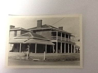
Relates to a series of 5 photos:P000094-P000098 of the front of the Bridge Hotel on the corner of Murray esplanade and Hopwood gardens. These photos taken in 1976, were before the Port Restoration Scheme renovated the hotel.The Bridge Hotel, Echuca is of historical and social significance in that it was originally built by Henry Hopwood, the founder of Echuca. Hopwood built the hotel to provide accommodation to people using his punts across the Campaspe and Murray rivers. The hotel was situated between the 2 punts. The hotel provided for a variety of levels of accommodation from grand rooms to very basic rooms. At the time of the photos the hotel was 120 years old and became an important part of the Port of Echuca tourism. Black and white photograph of the Bridge Hotel , taken from the corner of Murray esplanade and Hopwood gardens. A power pole pokes through the verandah roof of the eastern (left) wing. The eastern wing of the Bridge is clearly visible.On sign on the front verandah "unauthorised entry not permitted". On back of photo in pen :" 1"bridge hotel, echcua, port restoration scheme, bridge hotel restoration, echuca -
 Orbost & District Historical Society
black and white photograph, 1971
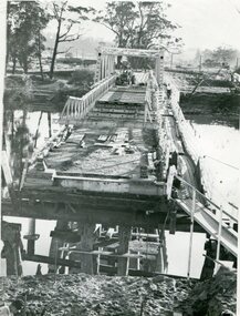
This photograph shows the second major bridge across the Snowy River at Orbost. The current Snowy River bridge is the fourth to provide a crossing to the township of Orbost. The first, in 1891, lasted just two years before it succumbed to flood waters. The bridge in this photograph was built in the 1920s as a road and rail bridge, and was again partly washed away by flood waters in 1934. After the end of the first World War the Victorian Railways considered an extension of the railhead across the river at Orbost, and in 1922 a new timber and steel girder structure, a joint Country Roads Board — Victorian Railways venture, was built and completed at a cost of £41,000 (the steel girders came from the Flinders Street viaduct reconstruction). Subsequently it was decided not to take the railway across the river, and the bridge was only used by road traffic. It was severely battered by floods during its life. and after the devastating 1971 floods was eventually replaced by the current bridge in 1975. (info from Newletter 54N by John Phillips)This is a pictorial record of the flood damage in 1971 when part of the Snowy River Bridge was washed away.A black / white photograph of a bridge which has been damaged by floodwaters. It shows one end has been washed away.orbost-snowy-river-bridge-1971 floods-orbost-1971 -
 Lakes Entrance Historical Society
Photograph - Footbridge, Holding M, 1985c
... Bridges ...Colored photograph of the footbridge. It shows seagulls on the weed covered northern edge of the lake, people on bridge, roof of surf lifesaving club house visible among dunes of south shore. Lakes Entrance Victoriawaterways, bridges -
Glenelg Shire Council Cultural Collection
Photograph - Photograph - Killara Bridge over Glenelg River, c. 1963
Sourced from Casterton Town Hall (former Shire of Glenelg)Black and white photo. View of Killara Bridge over Glenelg RiverFront: Black stamp - 003635 Back: 'View of Killara Bridge over Glenelg River' - handwritten in pencil. Blue biro line arrowed both ends, drawn across width of photo. 3" in blue biro written above line -
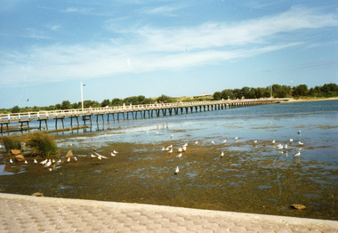
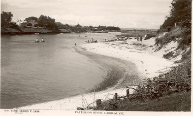 Chelsea & District Historical Society Inc
Photograph - Patterson River, Rose Series Postcard
The first bridge over the river was built in the early 1880's, prior to this it was a pontoon bridge.Black and white photo of Patterson River, looking east from the Patterson River Bridge. People in canoes on the river and sitting on the river bank. Houses can be seen on the opposite bank.THE ROSE SERIES P. 2908 - PATTERSON RIVER, CARRUM, VICpatterson river, chelsea, patterson river bridge, carrum bridge, canoes, beach, leisure, the rose series -
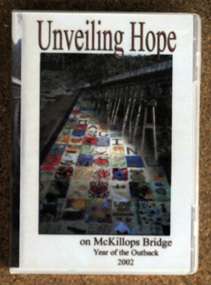 Orbost & District Historical Society
D.V.D, Jenkins, Daniel - Hot Dog Films, Unveiling Hope, 8.8.2002
As part of the Crelebration of the Year of the Outback, McKillop's Bridge in the Deddick Valley was hung with nineteen banners made by individuals and groups of East Gippsland. Banners containing thousands of messages of hope and optimism for the future of rural communities were suspended from he bridge in the Snowy River National Park, in front of a three hundred strong crowd that had assembled. Sister Helen Barnes from the Sisters of St Joseph Order, founded by Mary McKillop, initiated the project. This event was a significant event in local history and this item is a contemporary recording of it.A D.V.D. titled, Unveiling Hope. On the front is a coloured photograph of McKillop's Bridge in the Deddick Valley.mckillop's-bridge banners-of-hope -
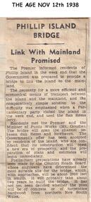 Phillip Island and District Historical Society Inc.
Newspaper clippings, 12/11/1938
... bridges ...Article in The Age newspaperArticle stating that a bridge linking San Remo and Phillip Island will be built.local history, documents, newspapers, bridges, phillip island, black & white newspaper clipping, mr dunstan premier of victoria -
 Phillip Island and District Historical Society Inc.
Newspaper clippings
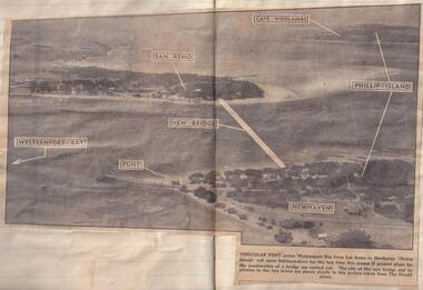
... bridges ...Aerial photograph in newspaperAerial photograph of site of proposed bridge between San Remo and Newhaven.local history, documents, newspapers, bridges, phillip island, black & white newspaper clipping, phillip island. -
 Phillip Island and District Historical Society Inc.
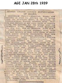
Newspaper clippings, 28/01/1939
... bridges ...Newspaper clippingContract to supply of aggregate for concrete to the site of the new bridge at Phillip islandlocal history, documents, newspapers, bridges, phillip island, black & white newspaper clipping, phillip island. -
 Sunbury Family History and Heritage Society Inc.
Photograph
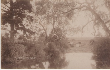
The Jacksons Creek and the Macedon Street stone arched bridge are the features in this postcard with a view of a vineyard on the LH river bank. The wine industry was one of the early industries caroused out in Sunbury by the early European settlers in the district.A sepia photograph in post card format of a waterway with overhanging trees and an arched bridge in the middl;e distance.JACKSONS CREEK, SUNBURYjacksons creek, macedon street bridge, vineyards. -
 Lakes Entrance Historical Society
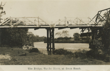
Postcard, Howard Bulmer, Tambo River Swan Reach Victoria c1920, 1920 c
This bridge collapsed in 1925 NovemberSepia photograph of bascule bridge over the Tambo River showing part of lifting gear on right hand side of photograph, Swan Reach Victoriabusinesses -
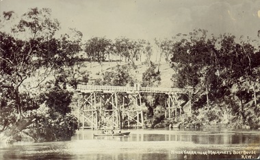 Kew Historical Society Inc
Postcard, J.W.K. & Co, River Yarra near Macauleys' Boathouse Kew, c.1910
The Zig-Zag Bridge which was constructed in the 1870s to link the Yarra Bend Asylum and Kew Asylum. Initially it transported bluestone from the west side of the Yarra to the east during the construction of the Kew Asylum.Real photo postcard of the Zig-Zag Bridge at Kew. In the middle ground there is a rowboat.Obverse: "River Yarra near Macauleys' Boathouse Kew". Reverse: "Gift from L Bennett"bridges -- river yarra, bridges - kew (vic.), zig-zag bridge -
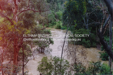 Eltham District Historical Society Inc
Photograph, Flooding of Diamond Creek at Lower Eltham Main Road bridge, Nov 2004, 2004
... bridges ...Two colour photographs of the flooded Diamond Creek at the Lower Eltham Main Road bridge in Nov 2004eltham, main road, bridges, diamond creek, floods -
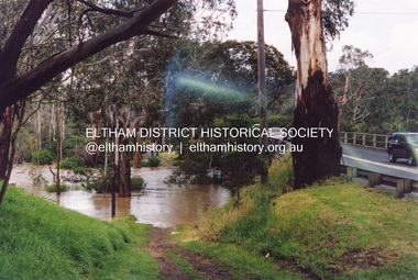 Eltham District Historical Society Inc
Photograph, Flooding of Diamond Creek at Lower Eltham Main Road bridge, Nov 2004, 2004
... bridges ...Two colour photographs of the flooded Diamond Creek at the Lower Eltham Main Road bridge in Nov 2004eltham, main road, bridges, diamond creek, floods -
 Lakes Entrance Historical Society
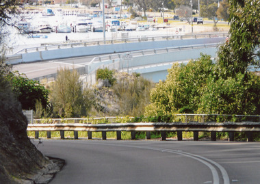
Photograph - North Arm Bridge, 2008
... Bridges ...Date made August 2008|This is the after paired photograph used in the 150 year Lakes Entrance 1858-2008 display.Colour photograph of the approach to the North Arm bridge. Boats moored at jetties in the background. Lakes Entrance Victoriabridges, fences, animals, roads and streets, room display -
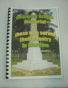 St Arnaud and District Historical Society
Book. Coonooer Bridge Memorial, Coonooer Bridge Memorial to those who served their Country in Wartime
Following the Great War of 1914-18 the people who lived in the general area around Coonooer Bridge , (18 kms from St.Arnaud ) erected a Monument in honour of those men and women who served their country in a time of war. In 1920 the monument was erected across from the hall, situated in a small pine plantation which was also planted by community members. The names of those that served their country during war time were placed on the monument. After the 2nd World War the names of the local men and women who once again were asked to serve their country were added to the memorial to honour and remember the sacrifice that they made.This book was compiled to honour and enable families and future generations to remember those who served.This is the only book listing these servicemen that served from the Coonooer Bridge Area.Spiral plastic bound book.Clear perspex cover. Coloured pages.Includes photographs of servicemen, medals and war service information.Dedicated to the people of Coonooer Bridge. -
 Lakes Entrance Historical Society
Photograph - North Arm Bridge, 2008
... Bridges ...Date made September 2008Colour photograph showing the new North Arm bridge opened 2000, taken from pathway besides Princes Highway at west end of Lakes Entrance, Victoria.bridges, waterways, roads and streets -
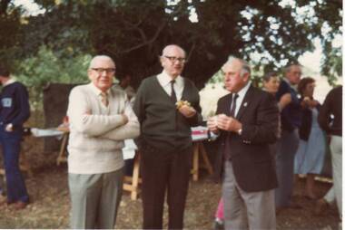 Clunes Museum
Photograph
... bridges ...THEO HARDEN, FRANK COLLINS & HARRY TOOLE AT THE OPENINGOF THE SUSPENSION BRIDGE OVER CRESWICK CREEK, CLUNES. 14/4/1986local history, photography, photographs, bridges -
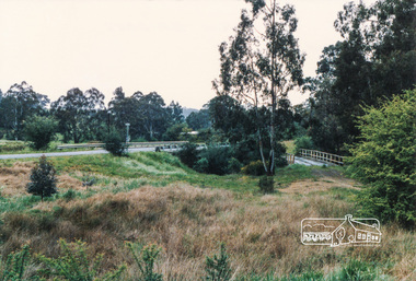 Eltham District Historical Society Inc
Photograph, Burkes Bridge, Hurstbridge
... bridges ...Colour photograph showing the old and new Burkes Bridges over Arthurs Creek, Hurstbridgeburkes bridges, bridges, hurstbridge, hurstbridge arthurs creek road, arthurs creek road, arthurs creek