Showing 1039 items
matching built heritage
-
 Bendigo Historical Society Inc.
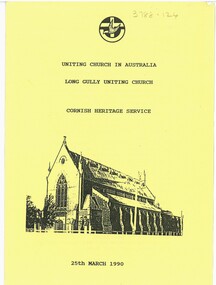
Document - Long Gully Uniting Church - Cornish Heritage Order of Service 25 March 1990, 23/02/1986
The initial Methodist Church at Long Gully was a slab hut and in 1855 the first brick building was erected. This was replaced in 1865 by a brick church designed by architects Vahland and Getzschmann. In 1877 the present church, designed by the same architects was built, with the 1865 building becoming the Sunday school. A large part of the congregation was Cornish miners of whom there were large numbers in Long Gully and California Gully.A4 Sheet printed both sides of page, sketch of Long Gully Uniting Church on the front cover.religion, lydia chancellor collection, history, church -
 Bendigo Historical Society Inc.
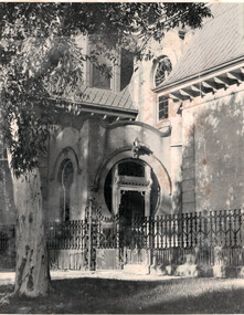
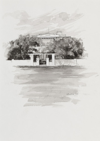
Document - Coolock House / Denderah, 01/04/1981
The ground floor of "Denderah" was built in 1880 for Mr D White. In 1910 the upper floor was designed by architect William Beebe for George Victor Lansell, son of George Lansell. When George Victor died in 1958, the house was incorporated into Catholic College, Bendigo. It was renamed Coolock House after a property in Ireland by the same name, that was inherited by Catherine McCauly enabling her to begin her charitable work educating and finding work for the poor in Dublin. It is now on the Victorian Heritage Register.Coolock House View Street Bendigo, formerly Denderah. Photo of Coolock House and letters re citation from the National Trust BendigoOn rear of photo: Bendigo Regional Photographic Library for private and research purposes only.history, national trust bendigo collection, coolock house -
 Bendigo Historical Society Inc.
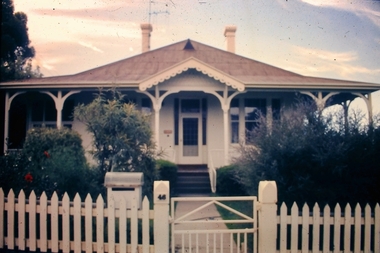
Slide - National Trust 46 Rowan Street, Edwardian Built 1908
The Bendigo & Region Branch is the National Trust’s voice in the region. The Branch works with council and the community on local heritage issues. New members are always welcome at any of the Branch’s meetings and events.National Trust Photo of 46 Rowan Street, Edwardian Built 1908. history, bendigo, national trust collection bendigo, 46 rowan street bendigo -
 Bendigo Historical Society Inc.
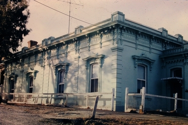
Slide - Osborne House 33 MacKenzie Street Bendigo
The Bendigo & Region Branch is the National Trust’s voice in the region. The Branch works with council and the community on local heritage issues. New members are always welcome at any of the Branch’s meetings and events. Designed by renown Bendigo architects Vahland and Getzschmann, Osborne House was originally built as a private school in 1869, extended in 1870 and sold in 1888 when it became a boarding house. The property enjoys a privileged position surrounded by more of Vahland's inspiring designs - the Forest Street Anglican, Methodist and Congregational churches while just over the hill, the massive spire of the Sacred Heart Cathedral dominates the skyline. Both the skyline and the residence have undergone much change over the last century and now enjoy a harmonious blend of traditional form and modern function. Beyond the secluded front entry, Osborne House offers grand Victorian proportions blended seamlessly with a timeless French influence. Built over three levels, the residence has four bedrooms plus home office, grand formal lounge and dining roomsOsborne House 33 MacKenzie Street Bendigo - Slidehistory, bendigo, national trust collection bendigo, osborne house 33 mackenzie street bendigo -
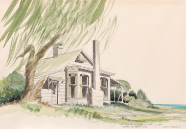 Bayside Gallery - Bayside City Council Art & Heritage Collection
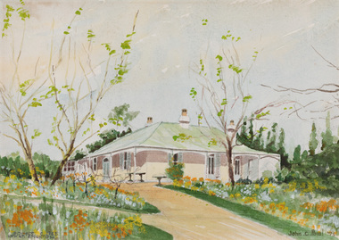
Work on paper - watercolour, John C. Paul, St. Ninian's north elevation c.1841, 1971
Built around 1841, St Ninian’s, located at 10 Miller Street, was one of Brighton’s earliest buildings. It is best known as being the home of merchant shipping agent, politician and former British naval officer, George Ward Cole between the 1840s and 1902. Following the death of George Ward Cole in 1879 and his wife in 1898, their only surviving child, Margaret, sold the property to Sir Thomas Bent, who subdivided the land in the early 1900s. The property was demolished in 1974. John C. Paul, St. Ninian's north elevation c.1841 1971, watercolour, 29.5 x 42.3 cm. Bayside City Council Art and Heritage Collection. Purchased 1974.st ninian's, brighton, historic house, george ward cole, thomas bent -
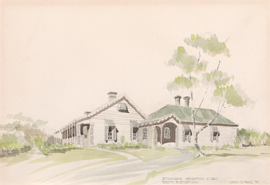 Bayside Gallery - Bayside City Council Art & Heritage Collection
Work on paper - watercolour, John C. Paul, St. Ninian's south elevation c.1841, 1971
Built around 1841, St Ninian’s, located at 10 Miller Street, was one of Brighton’s earliest buildings. It is best known as being the home of merchant shipping agent, politician and former British naval officer, George Ward Cole between the 1840s and 1902. Following the death of George Ward Cole in 1879 and his wife in 1898, their only surviving child, Margaret, sold the property to Sir Thomas Bent, who subdivided the land in the early 1900s. The property was demolished in 1974. John C. Paul, St. Ninian's south elevation c.1841 1971, watercolour, 29.5 x 43 cm. Bayside City Council Art and Heritage Collection. Purchased 1974.st ninian's, brighton, historic house, george ward cole, thomas bent -
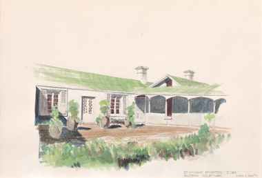
 Bayside Gallery - Bayside City Council Art & Heritage Collection
Work on paper - watercolour, John C. Paul, St. Ninian's servants' quarters, 1975
Built around 1841, St Ninian’s, located at 10 Miller Street, was one of Brighton’s earliest buildings. It is best known as being the home of merchant shipping agent, politician and former British naval officer, George Ward Cole between the 1840s and 1902. Following the death of George Ward Cole in 1879 and his wife in 1898, their only surviving child, Margaret, sold the property to Sir Thomas Bent, who subdivided the land in the early 1900s. The property was demolished in 1974. John C. Paul, St. Ninian's servants' quarters 1975, watercolour, 27.5 x 39.6 cm. Bayside City Council Art and Heritage Collectionst ninian's, brighton, historic house, george ward cole, thomas bent, servants' quarters -
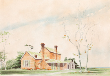
 Bayside Gallery - Bayside City Council Art & Heritage Collection
Work on paper - watercolour, John C. Paul, St. Ninian's eastern courtyard c.1841, 1971
Built around 1841, St Ninian’s, located at 10 Miller Street, was one of Brighton’s earliest buildings. It is best known as being the home of merchant shipping agent, politician and former British naval officer, George Ward Cole between the 1840s and 1902. Following the death of George Ward Cole in 1879 and his wife in 1898, their only surviving child, Margaret, sold the property to Sir Thomas Bent, who subdivided the land in the early 1900s. The property was demolished in 1974. John C. Paul, St. Ninian's eastern courtyard c.1841 1971, watercolour, 28.5 x 40.8 cm. Bayside City Council Art and Heritage Collection. Purchased 1974.st ninian's, brighton, historic house, george ward cole, thomas bent, courtyard -
 Bayside Gallery - Bayside City Council Art & Heritage Collection
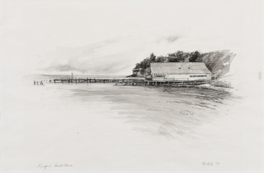
Work on paper - ink and watercolour, Annette Meikle, Keefer's boat shed, 1977
In 1977, artist Annette Meikle undertook a commission to illustrate a book recording stories of places and people in the Bayside area. It was published in 1978 as Sandringham Sketchbook, with text by Elizabeth Waters. The sketches were intended to record remaining examples of Bayside’s early architecture and environment, as well as reflect newer architectural changes. Meikle went on to donate 22 of these sketches to Bayside City Council in 2003. Charles Keefer established this landmark boat hire business in the early twentieth century, shortly after he had built municipal baths at Beaumaris. The original boat shed was damaged in a storm in 1934 and burned down in 1984.Annette Meikle, Keefer's boat shed 1977, ink and watercolour, 33 x 53.5 cm. Bayside City Council Art and Heritage Collection. Donated by the artist, 2003annette meikle, sandringham sketchbook, elizabeth waters, port phillip bay, coastline, beaumaris, keefer's, keefer's boat shed, jetty, boat shed -
 Bayside Gallery - Bayside City Council Art & Heritage Collection
Work on paper - ink and watercolour, Annette Meikle, Band Rotunda, 1977
In 1977, artist Annette Meikle undertook a commission to illustrate a book recording stories of places and people in the Bayside area. It was published in 1978 as Sandringham Sketchbook, with text by Elizabeth Waters. The sketches were intended to record remaining examples of Bayside’s early architecture and environment, as well as reflect newer architectural changes. Meikle went on to donate 22 of these sketches to Bayside City Council in 2003. Built in 1926, the Band Rotunda was a gift to the people of Sandringham by local doctor and former soldier Thomas Garnet Leary. On Sunday afternoons throughout the inter-war years, brass bands such as the military uniformed 46th Battalion Brass Band and the popular Sandringham Boys Band would play. The canopied top storey comfortably held twenty five performers with enough room for their large instruments. Large crowds would picnic along the foreshore listening to the performances. The drinking fountain pictured under the rotunda has since been removed.Annette Meikle, Band Rotunda 1977, ink and watercolour, 33.8 x 23.5 cm. Bayside City Council Art and Heritage Collection. Donated by the artist, 2003annette meikle, sandringham sketchbook, elizabeth waters, band rotunda, sandringham, thomas garnet leary, foreshore -
 Bayside Gallery - Bayside City Council Art & Heritage Collection
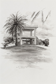
Work on paper - ink and watercolour, Annette Meikle, Black Rock House, 1977
In 1977, artist Annette Meikle undertook a commission to illustrate a book recording stories of places and people in the Bayside area. It was published in 1978 as Sandringham Sketchbook, with text by Elizabeth Waters. The sketches were intended to record remaining examples of Bayside’s early architecture and environment, as well as reflect newer architectural changes. Meikle went on to donate 22 of these sketches to Bayside City Council in 2003. Black Rock House was built in 1858 by wealthy land dealer and politician Charles Hobson Ebden as a holiday home on 112 acres of virgin scrub, taking in the area of present day Balcombe Road, Beach Road and the line of Keating Street. The house included four bedrooms, a cellar, stables and a courtyard enclosed in castle-like sandstone walls. It was named Black Rock House after Black Rock Castle near Dublin, associated with Mrs Ebden’s childhood.Annette Meikle, Black Rock House 1977, ink and watercolour, 33 x 53.5 cm. Bayside City Council Art and Heritage Collection. Donated by the artist, 2003annette meikle, sandringham sketchbook, elizabeth waters, black rock house, black rock, charles hobson ebden, architecture, historic house -
 Bayside Gallery - Bayside City Council Art & Heritage Collection
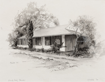
Work on paper - ink and watercolour, Annette Meikle, Shenval, 1977
In 1977, artist Annette Meikle undertook a commission to illustrate a book recording stories of places and people in the Bayside area. It was published in 1978 as Sandringham Sketchbook, with text by Elizabeth Waters. The sketches were intended to record remaining examples of Bayside’s early architecture and environment, as well as reflect newer architectural changes. Meikle went on to donate 22 of these sketches to Bayside City Council in 2003. Built in 1891 for Captain Murray to his own design, ‘Shenval’ originally stood on five acres fronting Bluff Road, Black Rock.Annette Meikle, Shenval 1977, ink and watercolour, 33 x 23.5 cm. Bayside City Council Art and Heritage Collection. Donated by the artist, 2003annette meikle, sandringham sketchbook, elizabeth waters, black rock, architecture, historic house, shenval, captain murray, bluff road, verandah -
 Bayside Gallery - Bayside City Council Art & Heritage Collection
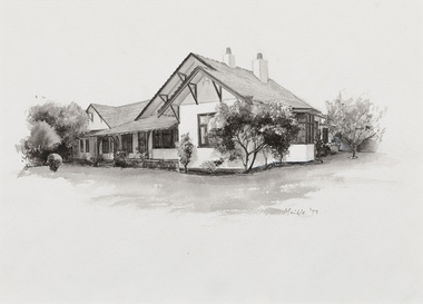
Work on paper - ink and watercolour, Annette Meikle, Hollyburton, 1977
In 1977, artist Annette Meikle undertook a commission to illustrate a book recording stories of places and people in the Bayside area. It was published in 1978 as Sandringham Sketchbook, with text by Elizabeth Waters. The sketches were intended to record remaining examples of Bayside’s early architecture and environment, as well as reflect newer architectural changes. Meikle went on to donate 22 of these sketches to Bayside City Council in 2003. ‘Hollyburton’ was built in 1908 by the Honourable JV Fairbairn MHR and is notable for its Australian-style arts and crafts detailing. Located on Fernhill Road, Sandringham, it covered 930 square metres and included a servants’ wing.Annette Meikle, Hollyburton 1977, ink and watercolour, 25.8 x 35.6 cm. Bayside City Council Art and Heritage Collection. Donated by the artist, 2003annette meikle, sandringham sketchbook, elizabeth waters, hollyburton, honourable jv fairbairn mhr, arts and crafts, architecture, historic house, fernhill road, sandringham -
 Bayside Gallery - Bayside City Council Art & Heritage Collection
Work on paper - ink and watercolour, Annette Meikle, Karinga, 1977
In 1977, artist Annette Meikle undertook a commission to illustrate a book recording stories of places and people in the Bayside area. It was published in 1978 as Sandringham Sketchbook, with text by Elizabeth Waters. The sketches were intended to record remaining examples of Bayside’s early architecture and environment, as well as reflect newer architectural changes. Meikle went on to donate 22 of these sketches to Bayside City Council in 2003. This inter-war house located at 60 Bluff Road, Black Rock, was built in 1926 for former Scotland Yard and Criminal Investigation Branch detective Horatio Reginald Clarence McWilliams. When McWilliams died it was found that he had taken extreme measures to protect his security. All the windows were nailed shut, a network of burglar alarms ran through the house and a complicated underground air raid shelter had been built in the garden. The security measures were at odds with the name of the house – Karinga or Karinya – an Aboriginal word meaning peaceful, happy home. Later residents of ‘Karinga’ included Senator Don Chipp and his family. The property has since been demolished and apartments have been built on the land.Annette Meikle, Karinga 1977, ink and watercolour, 32 x 23.5 cm. Bayside City Council Art and Heritage Collection. Donated by the artist, 2003annette meikle, sandringham sketchbook, elizabeth waters, black rock, karinga, karinya, horatio reginald clarence mcwilliams, senator don chipp, historic house, bluff road -
 Bayside Gallery - Bayside City Council Art & Heritage Collection
Work on paper - watercolour, John C. Paul, Boort c.1965, 1975
Originally built around 1869-74, the residential house Boort which was located at 266 New Street, Brighton was sold to Brighton Grammar in 1968 and was subsequently demolished in 1974.John C Paul, Boort c.1965 1975, watercolour, 27.2 x 38.3 cm. Bayside City Council Art and Heritage Collection.brighton, john c paul, historic house, boort, new street, brighton grammar -
 Bayside Gallery - Bayside City Council Art & Heritage Collection
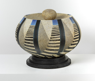
Ceramic - stoneware, Garry Bish, Cauldron, 2011
wheel thrown and hand built stoneware, wax resist, stencil and airbrushed glaze and stainsceramic, stairs, sky, stencil, stoneware, garry bish, cauldron -
 Bayside Gallery - Bayside City Council Art & Heritage Collection
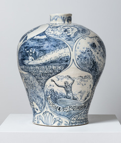
Ceramic - stoneware, Gerry Wedd, Wayne Lynch pot, 2015
hand-built, slip decorated and glazed, mid-fired stonewarestoneware, ceramic, surf, wayne lynch, gerry wedd, flowers, waves, beach, urn, vase -
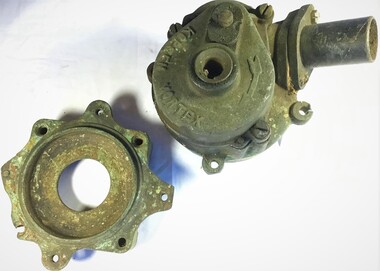 Queenscliffe Maritime Museum
Functional object - Vortex Pump
... that the heritage of this Lacco-built boat fishing boat is preserved..., ensuring that the heritage of this Lacco-built boat fishing boat ...For over 45 years, Richard has used Wendy regularly for recreational fishing and occasional sailing out of Queenscliff. He has the original cotton canvas sails that were fitted on the boat when she was built, and which still are in working condition. Richard says that one of his favourite pastimes has been trolling for pike around Swan Island, close by Queenscliff, ensuring that the heritage of this Lacco-built boat fishing boat is preserved. In about 2015, Wendy underwent a rebuild including: a new centre-case, ribs and deck, and a new Yanmar engine. The works were done by Bryon Miller of Peninsula Wooden Boats. Wendy remains berthed, fore and aft, at Number 12 pile in front of Queenscliff Lonsdale Yacht Club. Well known couta boat in QueenscliffeAustralian made Kopsen vortex bilge pump.Kopsen Vortexcouta boats, 'wendy", bilge pump -
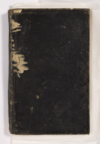 Queenscliffe Maritime Museum
Document - Diary of John Clarke 1850 to 1883, John Clarke, Personal diary of John Clarke, 1850 to 1883
The wreck site identified as the Columbine, a two masted brig built in 1839 in Aberdeen, Scotland and wrecked on the 1st April 1854 at Ocean Grove, Victoria, was formally reported to Heritage Victoria as located on the 15th January 2003 by Peter Ferrier and Don Love. As the site is over 75 years old it is automatically protected under the Commonwealth Historic Shipwrecks Act 1976. This diary is important as it outlines the eye witness account of the last moments of the Barque Columbine which is primarily of historic, technical, social and archaeological significance internationally and to the State of Victoria. It is a unique original account of that episode in early migrant history of Victoria and of Australia.A small leather bound black diary containing entries by John Clarke from 1843 to 1883, recording aspects of his life in Australia from the wreck of the Colombine as a child [approx 13 y.o.a.] to his experiences working in the gold fields and around the Geelong area. The diary is extensively damaged.john clarke, barque colombine, approaches to port phillip, ship wrecks, south coast -
 Buninyong & District Historical Society
Photograph - Original Colour Photograph, Anne Beggs-Sunter, 'Ballantree" homestead, Geelong Road, Buninyong, built in 1857, 1993
... of the National Estate, built in 1857. Heritage Status: On Victorian ...Heritage Status: On Victorian Heritage Register and the register of the National Estate, built in 1857.Heritage Status: On Victorian Heritage Register and the register of the National EstateColour Photograph of "Ballentree" homestead, 1857. Partial frontal view of homestead showing the verandah valences of carved Baltic pine fretwork. Shrubbery in foreground partially obscuring view.buninyong, ballantree, homestead, wb smith, timber fretwork, weatherboard house -
 Moorabbin Air Museum
Machine - DAP (Bristol) Beaufort Mk V A9-13 (T9552, "Nk-B")
Historical Details: The DAP Beaufort A9-13 was the 13th locally built Australian mark V Beaufort Bomber, with the first 20 being assembled from imported UK parts, but fitted with Australian built Pratt and Whitney 1830 Twin Row Wasp engines. A9-13 was originally built to an. Description: The DAP (Bristol) Beaufort Bomber A9-13, the 13th example built in Australia, was acquired in 2011 with Government funding assistance under the Australian National Cultural Heritage Account. The Beaufort Bomber was the first product of the Department o. Level of Importance: Nationalbeaufort -
 Kew Historical Society Inc
Plan - Subdivision Plan, H C Crouch, Old Golf Links Estate, 1930s
The land in North Kew between the Outer Circle Railway and the River Yarra was released in sections. This release included 80 lots. Most of this area was released during the Depression years in the early 1930s.Subdivision plans are historically important documents used as evidence of the growth of suburbs in Australia. They frequently provide information about when the land was sold on which a built structure was subsequently constructed as well as evidence relating to surveyors and real estate and financial agents. The numerous subdivision plans in the Kew Historical Society's collection represent working documents, ranging from the initial sketches made in planning a subdivision to printed plans on which auctioneers or agents listed the prices for which individual lots were sold. In a number of cases, the reverse of a subdivision plan in the collection includes a photograph of a house that was also for sale by the agent. These photographs provide significant heritage information relating house design and decoration, fencing and household gardens.One part of a massive subdivision of the Old Golf Links Estate in North Kew of 80 allotments bordering Sutherland Avenue, Ramsay Avenue, Belford Road, Beresford Street and Coleman Avenue. Inset on the plan at the top left, the route of the Outer Circle Railway is clearly marked. The Kew Golf Links is identified in its current location. The land on which Greenacres Golf Club was to be constructed is at this time marked as ‘Recreation Ground’. The ‘new bridge’ over the Yarra at Burke Road is also marked on the inset map. The Plan identifies the surveyor (sic) H.C. Crouch BCE MVIS, 443 Little Collins St., Melbourne. The date of the subdivision auction sale in identified as Saturday September 25th at three o'clock.Annotations: "E" top left. "Golf Links" top right. Lots 73-76 ticked and listed as "6" poundssubdivisions -- kew (vic.), old golf links estate -
 Kew Historical Society Inc
Photograph - Cosy Five Roomed Rough Cast Bungalow, Kew, J E Barnes, c.1920
Subdivision plans are historically important documents used as evidence of the growth of suburbs in Australia. They frequently provide information about when the land was sold on which a built structure was subsequently constructed as well as evidence relating to surveyors and real estate and financial agents. The numerous subdivision plans in the Kew Historical Society's collection represent working documents, ranging from the initial sketches made in planning a subdivision to printed plans on which auctioneers or agents listed the prices for which individual lots were sold. In a number of cases, the reverse of a subdivision plan in the collection includes a photograph of a house that was also for sale by the agent. These photographs provide significant heritage information relating house design and decoration, fencing and household gardens. The photograph is also aesthetically significant as it was taken by J. E. Barnes, a nationally significant photographer. He was the most important photographer to have worked in Kew. He was active as a photographer in the district from c.1906 until his death in 1921. Best known as 'the Embarkation Photographer' (see the Australian War Memorial collection), Josiah Earl Barnes was also the official photographer employed by the Borough (and later Town, then City) of Kew. He clearly also completed commercial jobs for local businesses, as is the case in this photograph of a house for a local real estate and financial agent. A modest weatherboard house with rough-cast rendered walls. The gabled entrance incorporates elements of the Japanese aesthetic. The strong lines of the dark timber gable are reinforced by the colour and shape of the pickets in the fence. In contrast to an earlier period, the chimneys appear truncated. The use of extensive double-hung sash windows in the front rooms reflects a new interest in light in houses. The use of separate sunshades over windows in an earlier period is here replaced by an extension of the roofline over the window. The photographer Josiah Barnes died in 1921; so, the photograph of the house must predate this date. The location of the house, which was advertised for sale, has to date not been identified. Illegible inscription. Photographer's information on mount.josiah earl barnes, j e barnes, photography - kew, interwar housing - victoria, 1920s housing - kew -
 Kew Historical Society Inc
Photograph - 2 Young Street, Kew, Paramount Photos, 1920s
Subdivision plans are historically important documents used as evidence of the growth of suburbs in Australia. They frequently provide information about when the land was sold on which a built structure was subsequently constructed as well as evidence relating to surveyors and real estate and financial agents. The numerous subdivision plans in the Kew Historical Society's collection represent working documents, ranging from the initial sketches made in planning a subdivision to printed plans on which auctioneers or agents listed the prices for which individual lots were sold. In a number of cases, the reverse of a subdivision plan in the collection includes a photograph of a house that was also for sale by the agent. These photographs provide significant heritage information relating house design and decoration, fencing and household gardens.A prepossessing, large home constructed in the Arts and Crafts style. Located on the banks of the Yarra at 2 Young Street, Kew overlooking the factories of Richmond, the design of the house takes account of the gradient with the addition of a level below the front entrance. The elegant roof includes a number of projecting gables and dormers. The gables are typically half-timbered and rendered. In addition to the asymmetrically placed portico, there are at least two open verandas, supported by timber pillars and with roofs that reflect the overall pitch of the roof of the housereal estate photographs, 2 young street - kew -
 Kew Historical Society Inc
Photograph - 29 Uvadale Grove, Kew, 1920
The numerous subdivision plans in the Kew Historical Society's collection represent working documents, ranging from the initial sketches made in planning a subdivision to printed plans on which auctioneers or agents listed the prices for which individual lots were sold. In a number of cases, the reverse of a subdivision plan in the collection includes a photograph of a house that was also for sale by the agent. Subdivision plans are historically important documents used as evidence of the growth of suburbs in Australia. They frequently provide information about when the land was sold on which a built structure was subsequently constructed as well as evidence relating to surveyors and real estate and financial agents. These photographs provide significant heritage information relating house design and decoration, fencing and household gardens.When 29 Uvadale Grove, Kew was offered for sale it was described as: ‘Kew. Fine locality, 3 minutes Cotham Road. Splendidly built 6 roomed Brick Villa. Rooms 17 x 14, 16 x 13, &c. Beautifully fitted throughout. Land 70 x 134 to ROW.’ The price was advertised as being £1,400. The house exhibits key features of Federation architecture such as the gabled roof with a facing of half-timber and stucco. The veranda has a curved corrugated iron roof supported by timber pillars and fretwork. The slate roof with terra cotta ridging and finials marks a transition to the more common use of Marseilles tiles in Federation architecture.subdivisions - kew (vic.), 29 uvadale grove - kew (vic.) -
 Kew Historical Society Inc
Photograph - 'Mount Eri', 9 Highbury Grove, 1919
Subdivision plans are historically important documents used as evidence of the growth of suburbs in Australia. They frequently provide information about when the land was sold on which a built structure was subsequently constructed as well as evidence relating to surveyors and real estate and financial agents. The numerous subdivision plans in the Kew Historical Society's collection represent working documents, ranging from the initial sketches made in planning a subdivision to printed plans on which auctioneers or agents listed the prices for which individual lots were sold. In a number of cases, the reverse of a subdivision plan in the collection includes a photograph of a house that was also for sale by the agent. These photographs provide significant heritage information relating house design and decoration, fencing and household gardens.A photograph of Mount Eri, 9 Highbury Grove, an 11-room house for sale near the junction of Cotham and Glenferrie Roads. The substantial red brick, slate-roofed house and its location are not identified in the photograph, although the extent of the house is noted. It was described then as ‘well situated’ and close to 3 trams. Mathers, a financial agent in Cotham Road, placed advertisements about the sale of the property in The Argus in May and June 1919. The advertisement additionally refers to a billiard room and asserts that the house has every modern convenience. An annotation on the plan indicates that the house, with tennis court, was sold for £1960. Following extensive research, the house has now been conclusively identified, albeit extended and rendered. The house was originally built in the 19th century as a school and for much of the 20th century was used as a venue for receptions. -
 Kew Historical Society Inc
Photograph - Victorian Villa, High Street, c.1922
Subdivision plans are historically important documents used as evidence of the growth of suburbs in Australia. They frequently provide information about when the land was sold on which a built structure was subsequently constructed as well as evidence relating to surveyors and real estate and financial agents. The numerous subdivision plans in the Kew Historical Society's collection represent working documents, ranging from the initial sketches made in planning a subdivision to printed plans on which auctioneers or agents listed the prices for which individual lots were sold. In a number of cases, the reverse of a subdivision plan in the collection includes a photograph of a house that was also for sale by the agent. These photographs provide significant heritage information relating house design and decoration, fencing and household gardens.An old inscription on this photograph identifies it as ‘an elegant timber villa in High Street. It occupied part of Lot 91, bought by Edward Glyn in the land sale of 16th October 1851, and run as a flower farm’. The subdivision called the ‘Flower Farm Estate’ in East Kew occurred in 1922. [The subdivision plan is on the reverse of this photo.] The Estate included 61 lots on either side of Boorool Road between High Street and Harp Road. In the MMBW Detail Plan 2017 of 1926, a number of these new villas had already been built. Matching houses with MMBW maps can always be a challenge, however if this house was near the corner of Boorool Road and High Street, it seems to fit the profile of a house called ‘Maxton’ (demolished).Photographer's name on photograph, lower right, and stamp on mount lower right: "A. Aberline, Glenferrie".houses - maxton - high street - kew (vic.), violet farm estate, subdivisions - kew (vic.) -
 Kew Historical Society Inc
Photograph - 8 roomed DF Brick Villa, Kew, J E Barnes, c.1920
Subdivision plans are historically important documents used as evidence of the growth of suburbs in Australia. They frequently provide information about when the land was sold on which a built structure was subsequently constructed as well as evidence relating to surveyors and real estate and financial agents. The numerous subdivision plans in the Kew Historical Society's collection represent working documents, ranging from the initial sketches made in planning a subdivision to printed plans on which auctioneers or agents listed the prices for which individual lots were sold. In a number of cases, the reverse of a subdivision plan in the collection includes a photograph of a house that was also for sale by the agent. These photographs provide significant heritage information relating house design and decoration, fencing and household gardens. The photograph is of additional aesthetic significance as it was photographed by J. E. Barnes. Josiah Earl Barnes is a nationally significant photographer. He was also the most important photographer to have worked in Kew. He was active as a photographer in the district from c.1906 until his death in 1921. Best known as 'the Embarkation Photographer' (see the Australian War Memorial collection), J. Earl Barnes was also the official photographer employed by the Borough (and later Town, then City) of Kew. He clearly also completed commercial jobs for local businesses, as is the case in this photograph of a house for a local real estate and financial agent.A photograph, mounted on board of a double fronted Federation-era brick villa in Kew, photographed for a local real estate agent and financier by J. E. Barnes of Kew. On the reverse of the photograph is a subdivision plan for the Normanby Estate, East Kew - 2016.0039.1. As can be seen from the image, there is a large tear on the surface of the photograph.The brown card on which the photograph is mounted includes the following handwritten description, which may aid the identification of the house: "Kew, 3 minutes from tram, 8 roomed DF Brick Villa, tile roof including two attics, sleepout, bathroom, heater, E Light, Entrance Hall, double doors, leadlights, laundry, garden, lawns, land 75 x 170, 1975 pounds". Also photographers inscription on mount, lower left: J. E. Barnes / Photo / Phone 1966 Haw. KEW.j. e. barnes, josiah earl barnes, j. earl banes - photographer, architecture - federation style, houses - kew, real estate photographs -
 Kew Historical Society Inc
Photograph - W.B. Villa, Kew, c.1919
The photograph offers significant information relating to late Victorian / Federation colour schemes and fencing.The block fronted villa has a corrugated iron roof and a flat projecting verandah, ornamented with a trellis design of timber. The front window features a timber shade, mounted on brackets. The treatment of the block-fronted panels shows that there is an attempt to highlight imitation quoining through use of a darker colour. The windows and door are also in this darker shade. The front fence and gate are made of wooden pickets. It is unlikely that the photograph was taken at the time of the villa's construction given the size of the shrub/tree in the front garden.Subdivision plans are historically important documents used as evidence of the growth of suburbs in Australia. They frequently provide information about when the land was sold on which a built structure was subsequently constructed as well as evidence relating to surveyors and real estate and financial agents. The numerous subdivision plans in the Kew Historical Society's collection represent working documents, ranging from the initial sketches made in planning a subdivision to printed plans on which auctioneers or agents listed the prices for which individual lots were sold. In a number of cases, the reverse of a subdivision plan in the collection includes a photograph of a house that was also for sale by the agent. These photographs provide significant heritage information relating house design and decoration, fencing and household gardens.A real estate photograph, mounted on brown card, showing a double fronted weatherboard villa, located in Kew, Victoria. On the reverse of the photograph is a subdivision plan for the Altyre Estate.Stamped on mount: Top - "KEW. Close tram. Fine View. / W.B. Villa Containing 8 Rooms. / Up-to-date Conveniences. EL Etc." Below - "Land 40 x 165. 615 pounds. Sold"houses - kew, real estate photographs -
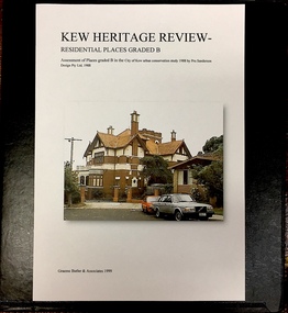 Kew Historical Society Inc
Archive (Sub-series) - Subject File, Kew Heritage Review, Residential Places Graded B, Volume 1, 1999, 1999
Graeme Butler & AssociatesProject FilesProvenance OrderBlack 4-Ring binder that includes research about, and an assessment of buildings previously graded B in the City of Kew Urban Conservation Study 1988 by Pru Sanderson Design Pty Ltd. The files were created by the heritage architect Graeme Butler and the paper files include maps, correspondence, title searches, readings, reviews of prior classifications, newspaper and journal articles, directories etc for each property assessed.graeme butler, heritage reviews - kew, 20 yarra street, 8 yarra street, 33 wills street, 25 wellington street, 11 wellington street, 118 walpole street, 84 walpole street, 83 walpole street, 63 walpole street, 52 walpole street, 51 walpole street, 14 vista avenue, 12 tara avenue, 89 studley park road, 75 studley park road, 44 studley park road, 25 studley park road, 13 studley avenue, 21 stoke avenue, 71 stevenson street, 34 stevenson street, 12 stevenson street, 36 stawell street, 11 second avenue, 3 second avenue, 2 second avenue, 34 rowland street, 21 redmond street, 11 redmond street, 16 queen street, 27 princess street, 82 molesworth street, 28 miller grove, 26 miller grove, 24 miller grove, 24 milfay avenue, 8 milfay avenue, 4 merrion grove, 25 mary street, 24 lister avenue, 2 john street, 9 hume street, 7 hume street, 24 howard street, 20 howard street, 19 howard street, 10 howard street, 2 howard street, 26 holroyd street, 12 holroyd street, 73 high street, 69 high street, 35 high street, 6 high street, 53 harp road, 6 gellibrand street, 48 foley street, 9 eglinton street, 25-27 edgecombe street, 21-23 edgecombe street, 5-7 edgecombe street, 23 dunlop avenue, 167 derby street, 8 denmark street, 1 denmark street, 2 daracomb avenue, 2 danielle place, 340 cotham road, 294 cotham road, 241 cotham road, 221-229 cotham road, 208 cotham road, 193 cotham road, 180 cotham road, 171 cotham road, 167 cotham road, 161 cotham road, 135-137 cotham road, 46 clyde street, 4 cameron court, 1291 burke road, 1223 burke road, 1205 burke road, 5 bowen street, 35-37 belford road, 389 barkers road, 387 barkers road, 311 barkers road, 231 barkers road, 83-85 barkers road, 15 adeney avenue, 6 a'beckett streetgraeme butler, heritage reviews - kew, 20 yarra street, 8 yarra street, 33 wills street, 25 wellington street, 11 wellington street, 118 walpole street, 84 walpole street, 83 walpole street, 63 walpole street, 52 walpole street, 51 walpole street, 14 vista avenue, 12 tara avenue, 89 studley park road, 75 studley park road, 44 studley park road, 25 studley park road, 13 studley avenue, 21 stoke avenue, 71 stevenson street, 34 stevenson street, 12 stevenson street, 36 stawell street, 11 second avenue, 3 second avenue, 2 second avenue, 34 rowland street, 21 redmond street, 11 redmond street, 16 queen street, 27 princess street, 82 molesworth street, 28 miller grove, 26 miller grove, 24 miller grove, 24 milfay avenue, 8 milfay avenue, 4 merrion grove, 25 mary street, 24 lister avenue, 2 john street, 9 hume street, 7 hume street, 24 howard street, 20 howard street, 19 howard street, 10 howard street, 2 howard street, 26 holroyd street, 12 holroyd street, 73 high street, 69 high street, 35 high street, 6 high street, 53 harp road, 6 gellibrand street, 48 foley street, 9 eglinton street, 25-27 edgecombe street, 21-23 edgecombe street, 5-7 edgecombe street, 23 dunlop avenue, 167 derby street, 8 denmark street, 1 denmark street, 2 daracomb avenue, 2 danielle place, 340 cotham road, 294 cotham road, 241 cotham road, 221-229 cotham road, 208 cotham road, 193 cotham road, 180 cotham road, 171 cotham road, 167 cotham road, 161 cotham road, 135-137 cotham road, 46 clyde street, 4 cameron court, 1291 burke road, 1223 burke road, 1205 burke road, 5 bowen street, 35-37 belford road, 389 barkers road, 387 barkers road, 311 barkers road, 231 barkers road, 83-85 barkers road, 15 adeney avenue, 6 a'beckett street