Showing 14288 items matching "drives"
-
 Whitehorse Historical Society Inc.
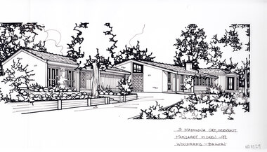
Artwork, other - Ink Line Drawing, Margaret Picken, 3 Madonna Crt., Vermont, 1999
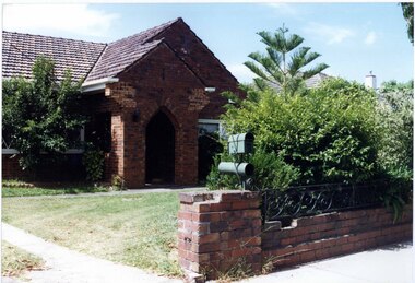
A property illustration by Margaret Picken Commissioned by a real estate agency for the purpose of advertising 3 Madonna Crt., Vermont This property has been subdivided into three, and 1/3 Madonna Crt., Vermont is listed as having sold for $1,100,000 in 2018 Made by using Rotring ‘Rapidigraph’ drafting pens with Rotring ink on Rapidigraph polyester drafting film, double matte. Trained as a cartographic draftsman within the mining industry, Margaret Picken is an artist who worked producing property illustrations for real estate agencies in eastern suburbs of Victoria from 1983-2005. Retiring from the industry as technological changes favored coloured photography over illustrations, and commissioning companies over sole contractors.This artwork is of Historical Significance as a record of local domestic architecture.A black ink line drawing on drafters film by Margaret Picken, of a single story house stretching from the left to the right along the center of the drawing. In the foreground a drive curves up to a connected garage. To the left and right are gardens, all the way up to the house. There are two hole punch holes just below centre of the upper edge3 Madonna Crt., Vermont Margaret Picken - 99 Woodards Balwynwhitehorse historical society, schwerkolt cottage, housing, architecture, margaret picken, house, garden, real estate, vermont, vermont south -
 Bendigo Historical Society Inc.
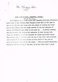
Document - TYPEWRITTEN ACCOUNT OF JOH MCCAVISTON'S WONDERFUL ESCAPE FROM THE HUSTLERS REEF MINE, 1873
Typewritten 10-page account of ''John McCaviston's Wonderful Escape'' (from the Hustlers Reef mine, 1873). Detailed story of shift boss, M'Caviston who descended into the flooding mine to warn workers below (who had actually left somewhat before) and who was himself trapped. The water in the shaft rose to a much higher level but M'Caviston was saved by being able to take refuge in a drive that had a 'stulling' (a mound of stones under a raised portion of the drive - allowing for an amount of trapped air). The account concludes as follows: ''The preservation of his life was discussed from a scientific point of view, and diverse opinions were expressed, and doubts (sic)'' (there is no page 11). No date on this document; handwritten on front page is ''The Flooded Mine'' ''By G Mackay'' (Occasional handwritten notations to text)document, names of bendigo pioneers, bendigo goldfields -
 Ballarat Tramway Museum
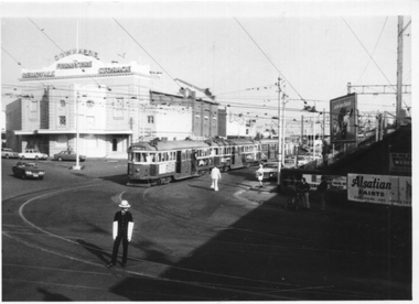
Slide - 35mm slide/s - set 16, John Theodore, 1/02/1975 12:00:00 AM
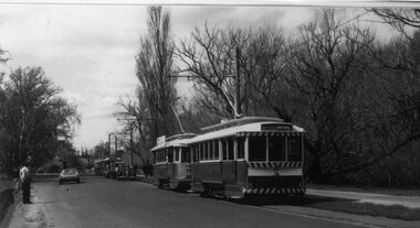
Yields information about the official opening by the BTPS of its operations in Wendouree Parade and tramcar operations afterwards.Set of 16 AGFA blue and white plastic mount 35mm slides of tram running after the official opening day of the BTPS Wendouree Parade tramway operations 1/2/1975. .1 - 14 and 26 in Wendouree Parade ready to carry passengers either way. .2 - 26 at St Aidans Drive .3 - 26 and another tram at St Aidans Drive .4 - 26 at Gardens Loop .5 - 26 Wendouree Parade .6 - 27 ditto .7 - 14 running in onto the access track. .8 - 27 in Wendouree Parade .9 - 40 at depot junction .10 - 27 at depot junction .11 - ditto running in .12 - 14 on access track .13 - 40 running in .14 - ditto .15 - ditto .16 - ditto Various notations by John as to the slide number and the trams in pencil and ink.tramways, trams, btps, opening, wendouree parade, depot, depot junction, st aidans drive, tram 40, tram 26, tram 14, tram 27 -
 Ballarat Tramway Museum
Photograph - Colour Photograph/s - set of 3, Austin Brehaut, 2/03/2002 12:00:00 AM
Set of three colour photographs of the Frank Puls and Austin Brehaut on the day of the funeral of Elizabeth the Queen Mother wearing black ties 2/4/2002. Photographs taken by a passenger (.1 and .2) and Austin Brehaut (.3) on the day using Frank's camera. Within the cataloguing file is a copy of the letter from Frank and a note from Richard Gilbert, via the Secretary. Photograph 2128.1 used in July 2002 Fares Please! Photos on Fujicolor Crystal Archive Paper. .1 - Frank Puls and Austin Brehaut standing in front of No. 26 at Depot Junction in Wendouree Parade .2 - ditto, but vertical format. Tram has destination of "St Aidans Drive" .3 - Close up of Frank, possibly at St Aidans Drive. Tram showing destination of "Depot"On rear of each photo in black ink "2/4/2002".funeral, wendouree parade, depot junction, tram 26 -
 Ringwood and District Historical Society
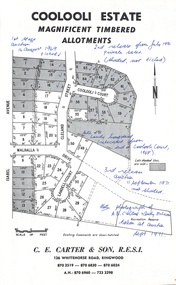
Document - Folder, Coolooli Estate Subdivision, Ringwood East, Vic. - Four Releases 1969-1975
Collection of Subdivision Plans, Land Sale flyers, Auction notices, and Real Estate Agent's notes for Coolooli Estate, Ringwood East, Victoria. Subdivision includes Coolooli Court, Isabel Avenue, Walhalla Drive, Cleland Street, Landell Court, Byways Drive, Heathwood Street and Hume Street, released over four stages - First Stage auction 16 August 1969, Second Release private sales from July 1970, Third Release Auction 11 September 1971, Final Release auction June 21st 1975. Agents - C.E. Carter & Son, 126 Whitehorse Road, Ringwood until moving to 122 Whitehorse Road in 1973 - Tel. 870 6024, 870 6830, 870 2519, A.H. 723 3298, 870 6960. Digitised copy of photograph - A.B. Carter and Andy McLean at Coolooli Estate auction, 11 September, 1971. -
 Eltham District Historical Society Inc
Slide, Looking westerly into Martins property, Lower Plenty, 18 July 1972, 1972
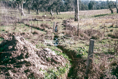
Water drainage work undertaken by Eltham Shire Council in Bonds Road, Lower Plenty outside the Martin property opposite Montpelier Drive, July 1972 Note natural gully conditions and open drain cleared through property with owner's consent.35 mm colour positive transparency Mount - Agfacolor Service (Blue)Bonds Road (Martin property) 12.10 pm 18.7.72bonds road, drainage works, eltham shire council, infrastructure, lower plenty, martin property, montpelier drive -
 Hume City Civic Collection
Photograph, early 1990s
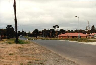
The series of 5 photographs feature different views of the Woodlands Housing Development which opened up land bounded by Gap and Anderson Roads, Cornish Street and Elizabeth Drive in the early 1990s. It was a large housing development built close to Sunbury township.A coloured photograph of one of the last housing developments which took place in the old township area. It is a photograph taken at the north end of Anderson Road looking towards Gap Road. One house has been built and there are a number of 'For Sale' signs of blocks fronting Anderson Road. Guttering and driveways have been formed on one side of the road.housing developments, anderson road, george evans collection -
 Hume City Civic Collection
Photograph, early 1990s
The series of 5 photographs feature different views of the Woodlands housing development which opened up land bounded by Gap and Anderson Roads, Cornish Street and Elizabeth Drive in the early 1990s. It was a large housing development built close to Sunbury township.A view of the northern boundary of the Woodlands housing development in Anderson Road. A paling fence divides the estate from the 'Malley' factory, now 'Storage King' which is on the corner of Cornish Street and Anderson Road. A 'For Sale' sign is in the foreground and a partly built house is in the middle distance.housing developments, anderson road, george evans collection -
 Ballarat Tramway Museum
Photograph - Ballarat Horse tram 1 - Wendouree Parade, Warren Doubleday, 7-11-1992
Colour print of Ballarat Horse Tram No. 1 with horses in Wendouree Parade departing Depot Junction with passengers for a trip to St Aidans Drive. Photo by Warren Doubleday on 7-11-1992. See also item 4086 for the actual launch photo.Yields information about the launch and the first operation of the horse tram in Wendouree Parade by the BTPS and has a strong association with those involved.Colour print with plain back.tramways, horse tram, tram 1, launch, btps, tramcars, reconstruction, wendouree parade -
 Melton City Libraries
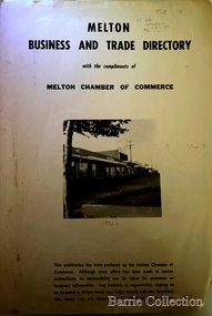
Booklet, Melton Business and Trade Directory, c.1965
BUSINESS TRADE AND DIRECTORY MAP NORTH of High Street RALIEGHS Road - Early settlers Oliver Reierson ( Norwegian) Raliegh SHEBLER Court Auguste EMIL Court Jongebloed Family residence “Hemlich” ALEXANDRA Street Coronation King, Queen Alexandra - 1903 O’NEILS Road Farmer OLDERSHAW Road CORR Grove Early landowner, Teacher at the Common School – Denominational Churches, 1850’s Wesleyan (Methodist) BRYAN Court 1850’s resident renamed from earliest town site - Flat HURLEY Street Early settler and farmers - CHESNEY Road was named Minns, due to duplication altered to Chesney (Minns) SOUTH of High ALKEMADE Drive. Family name ARNOLD Court Family BARRIES Road Charles Ernest Barrie “Darlingsford” 1911 Residence KILPATRICKS Road became Barries Road west of Station Road BLACKWOOD Drive Alexander, Early settler CALLANAN Drive Surveyor early LUBY Court John Luby - Crown Grant Land title KERWIN Street Michael - Crown Grant land title (deleted due to Freeway)Pamphlet of Melton Businesses and map of the townlocal identities, misc., council -
 Federation University Historical Collection
Laptop Computer, Acer, Acernote 350 Laptop Computer, 10/10/1995
The Acer was one of the first notebook computers used in the Electrical Engineering Department of the School of Engineering at the Ballarat University College. It was purchased in 1995 at a cost of $1800. The Acer Note350 has a 3½ inch floppy drive and a hard drive with a capacity of 401 megabytes and a ram capacity of 64 kilobytes. The operating system is Windows 95. The computer was used most often in conjunction with a data acquisition device plugged into the parallel port. In 1996 the equipment was setup to measure the forces of acceleration on a cricket bat caused by impact with the ball. This debunked a long held misconception that Composition balls used in a cricket bowling machine caused more damage to a bat than normal leather balls. Grey Plastic laptop computer, with black AC Adapter. Model 350C Ext No 0P3 Serial No M0006862 DC rating 20v 1.7a computer, ballarat university college, laptop -
Southern Sherbrooke Historical Society Inc.
Map - photocopy
A photocopy taken from the original land sale map provided to the society through Karel Coxell of Stockdale & Leggo. The original maps are stored in large bound account books and were originally the propert of McNally Real Estate. The books are held (in 2A3 photocopy of plan of survey of part of Crown Allotments 20 & 21, section C, parish of Narre Worran, County of Mornington. Clements Ave and environs in Belgrave Heights"Villette Estate" in top LH corner, "Locality Plan" in bottom LH corner, "Not in sale" written on one block and crossed out. All handwritten in pencil on original. "Colby Drive " and "Verona Street" added in pencil to copy.land sales, advertisements, subdivision -
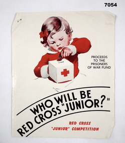 Bendigo Military Museum
Poster - POSTER, RED CROSS, Red Cross, "Who will be Red Cross Junior?", 1943
Refer Cat No’s 7028, 7029 for VAD, Red Cross and fund raising.This is a quarto sized poster with glossy white paper. Printing is in red ink. Main image shows a little toddler with red bow in her hair, placing a penny into a Red Cross money box. A sign in black ink beside it states - Proceeds to the Prisoners of War Fund. At the bottom is a little statement Red Cross 'Junior' Competition.Staple hole on top LHS. On the rear, in pencil, are the raffle plans and prizes = Babyset - Palmer Club Raffle - Wireless - (YMCA Dance on 17th) - Hann Raffle - Bicycle - Love Birds - Permit for (S..?) Ann - Radio Drive. ww2, pows, red cross -
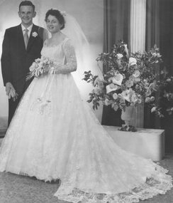 Ringwood and District Historical Society
Photograph, Wedding. Miss Betty Wood, 139 Bedford Rd. Heathmont. 1959
Black and white photographWritten on back of photograph: "Bride, Betty Wood, 139 Bedford Rd. Heathmont. Bridegroom, Arthur Dyasle, East Ringwood. 1959. Church of England, Ringwood. Reception, Drive In Croydon. Photo, Peter Payens Ringwood Studios." -
 Eltham District Historical Society Inc
Slide, Southern alignment of Montpelier Drive looking north up Bonds Road, Lower Plenty, 18 July 1972, 1972
Water drainage work undertaken by Eltham Shire Council in Bonds Road, Lower Plenty outside the Martin property opposite Montpelier Drive, July 1972 The water is not able to enter the pit on the northern side of Montpelier. It then flows along and across Bonds Road.35 mm colour positive transparency Mount - Agfacolor Service (Blue)Bonds Road (Martin property) 12.10 pm 18.7.72bonds road, drainage works, eltham shire council, infrastructure, lower plenty, martin property, montpelier drive -
 Melbourne Tram Museum
Photograph, David Menzies, Caulfield Loop - Caulfield Cup Day, 1975
Black and white print of a number of trams, lead by W2 245 parked in Railway Ave (now Sir John Monash Drive), Caulfield on Caulfield Cup day, 1975. A traffic policeman is on duty. In the background is Downards Furniture Store in a former picture theatre.Yields information about a Caulfield Cup race day and the tram services.Black and White photographs - printed on plain paper with photographers stamp and notes on rear.Has stamp of David Menzies on rear. and in ink details of photo.tramways, trams, mmtb, caulfield, races, caulfield races, railway ave, w2 class, tram 245 -
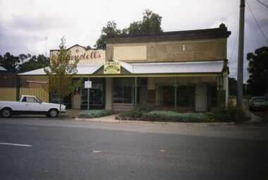 Charlton Golden Grains Museum Inc
Photograph, Brownjohn, Reg, Charlton High Street 1988, c.1988
Charlton High Street centre 1988. Vic Arundell's Shoe Shop, Stock & Station Agent and former W. Williams Saddlery (later Bullock's Grocery). Buildings latr demolished to become the Traveller's Rest. Williams St renamed John Curtin Drive.Colour photograph of Vic Arundell's shop and former W. Williams Saddlery on the corner of High St and Williams St. For Sale sign over the middle building. White ute parked in front of Arundell's. Another ute parked at side of buildings.bullocks grocery, business, industry, high street, arundell, shoe shop, saddlery, w. williams -
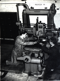 Federation University Historical Collection
Photograph - Image, Ballarat School of Mines Machine Shop, 1960s
A set of photos from the Ballarat School of Mines Machine Shop, showing students working with machine tools. .1) a centre lathe, with belt drive from overhead transmission .2) Cincinatti milling machine .3) Horizontal borer .4) P. Van Bergen and P. Johnson working on a jog borer in the Ballarat School of Mines machine shop machine shop, ballarat school of mines, jog borer, p. van bergen, p. johnson -
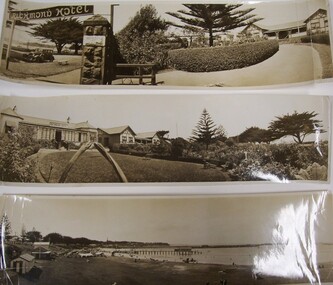 Glenelg Shire Council Cultural Collection
Photograph - Photograph - View of Richmond Hotel, 1934
Photographs taken by Esther Winifred Hall (nee Smallpage) - great grand-daughter of Stephen George Henty. Taken in 1934 Centenary celebrations in Portland.Back: "to E.....Hall from Mary Grant." (and further text)portland centenary celebrations 1934 -
 Glen Eira Historical Society
Photograph, Dalny Road, 11, Murrumbeena, 2001
Originally labelled "Beauville Estate, Established 1936, Still Thriving 65 years on, 10th March 2001", the Beauville Estate Album contains colour photographs of houses in the Estate. They were taken around the time of the Beauville Estate’s 65th Heritage Celebration held on 10/03/2001 and donated to the Caulfield Historical Society shortly afterwards. Photographer unknown. City of Glen Eira’s Heritage Management Plan Vol 2 p79 (this is p84 of the pdf version) – HO12 Beauville Estate and environs, Murrumbeena: The Beauville Historic Area is important at the State level as the first large housing estate undertaken by the AV Jennings Construction Co, later Jennings Group Limited, Victoria’s largest home builder. It is important also as a very early estate development incorporating a range of features other than houses and including made roads, shops and recreation facilities. In this respect it was the forerunner of the comprehensively planned housing estate of the post war era. The estate is distinguished by its aesthetic values, as is the earlier and comparable Hillcrest Estate, which are formed by a combination of restrained diversity in house styles, with the exception of no. 30 in the emerging International style, and by a landscaped garden environment. Colour photograph of an unpainted variegated brown brick house with decorative brickwork. Other features include tiled roof, enclosed porch with an arched entrance and black metal lantern and open window on the left side , garden, drive and a low slightly damaged unpainted brick fence with cast iron work railing in the foreground with a cast iron work letterbox on top.11murrumbeena, houses, architectural styles, 1930's, inter war style, a.v. jennings, av jennings, jennings, brick houses, beauville estate, dalny road, porches, sir albert victor jennings, a v jennings construction co, beauville estate heritage area, glen eira city council, architectural features, jennings group limited, land subdivision, gardens, beauville historic area, brick features, arches, cast iron work, letterboxes, brick walls -
 Bendigo Historical Society Inc.
Document - KEN HESSE COLLECTION: PROGRAM
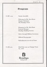
Program: 11.00 am Guest assemble Welcome by Mr. Ken Hesse Deputy Chairman The Bendigo Trust. Response by Mr. Rob Hunt General Manager Bendigo Building Society. Drive through Ribbon Ceremony. Official Photographs Refreshments served on Tram. 11.20 am Brief City tour on Vintage Tram No. 470. Sponsored by Bendigo Building Societyevent, social, reception -
 Ballarat Tramway Museum
Photograph - Bromide of a b/w photograph, Carolyn Dean, 26/09/1992 12:00:00 AM
Yields information about the BTPS 21st Anniversary celebrations which involved running a "all day" service and a cavalcade of trams.Bromide of a black and white photograph of the cavalcade of trams as part of the 21st celebrations of the closure of the Ballarat tramways on 26/9/1992. Photo appeared in the Sept. 1992 issue of Fares Please! Caption was "Tram No. 13, the service car meets up with cavalcade being prepared at St. Aidans Drive." Photo Carolyn Dean. See September 1992 Fares Please!trams, tramways, btps, 21st anniversary, wendouree parade, st aidans drive, cavalcade, tram 13 -
 Ballarat Tramway Museum
Photograph - digital Images, Peter Bruce
Has a strong association with the activities of the Ballarat tramway Museum in celebrating the 100th anniversary of the Geelong tramway opening in 1912, by using Geelong destinations on ex Geelong tramcars.Digital image of Ballarat No. 13 at Carlton St with the destination of Chilwell and at St Aidans Drive with the Geelong destination of Humble St. Part of marking the 100th anniversary of the opening of Geelong Tramways in March 1912 by the Ballarat Tramway Museum. Trams 13 and 14 were marked with different destinations. Photo by Peter Bruce 5/3/2012. Digital images.trams, tramways, geelong, chilwell, btm, carlton st, st aidans drive -
 Ballarat Tramway Museum
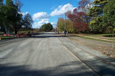
Photograph - Digital image Set of 12, Warren Doubleday, Wendouree Parade roadworks - April and May 2003, 27/4/2003 and 5/5/2003
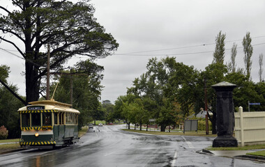
Set of 12 Digital Images of the reconstruction of the roadway at the north end or near St Aidans drive that was part of the project to lift the road above flood level. Images show the work in progress and at the tram terminus itself. The gutter was moved to the north and later on the gate pillar was shifted to the north as well. Photos dated 27/4/2003 and 5/5/2003.trams, tramways, road works, st aidans drive, wendouree parade, tram track -
 Ringwood and District Historical Society
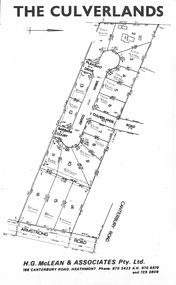
Document, Subdivision Plan - The Culverlands Estate, Heathmont, Victoria (undated, circa 1968)
Map of residential allotments for sale, with handwritten pricing notations and some marked "Sold". Subdivision includes Culverlands Road, Swain Court, Pleasant Drive, Barbara Court, and Armstrong Road, Heathmont. Agent - H.G. McLean & Associates Pty. Ltd., 166 Canterbury Road, Heathmont Vic., 3135, Telephones : 870-3422 A/hrs 870-5879 and 729-2809. -
 Melbourne Tram Museum
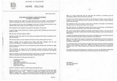
Document - Photocopy, Minister of Transport, "New tram line brings major improvement to public transport", 10/01/1985 12:00:00 AM
Press release - photocopied onto two A4 sheets, stapled in top left hand corner, issued 10/1/1985, titled "New tram line brings major improvement to public transport", for the opening of the tram line to Kingsbury Drive near Latrobe University - notes the background to the extension and future proposals to go to Bundoora. Opened by John Cain.trams, tramways, mta, opening, la trobe university -
 Bendigo Historical Society Inc.
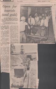
Newspaper - LYDIA CHANCELLOR COLLECTION: OPEN FOR TOURISTS (AND GOLD)
A Bendigo newspaper article titled 'Open for tourists (and gold).' The State Member for Midlands Mr. Bill Ebury, officially opened the Wattle Gully gold mine tourist project. There is a photo of Mr. Felix Cappy, Tourism chairman of the mine about to drive the train through the tunnel with his passengers and also coming out of the mine. 17/01/75.mine, gold, wattle gully, lydia chancellor collection, collection, bendigo, mine, mining, tourism, gold, history -
 Eltham District Historical Society Inc
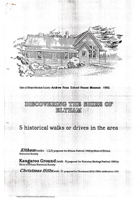
Document - Folder, Historical Walks, 1993
Includes: Eltham Festival 1992, Eltham Discovery Walks: 3 walks with short descriptions. "Kangaroo Ground Historical Notes" with points of interest highlighted for a walk or drive and map titled "Tour maps, Christmas Hills, 1992" with points of interest highlighted - and cover sheet 7 pages. Photocopiestour, walk, christmas hills, kangaroo ground, little eltham, eltham festival, armstrong, barr, bell, donaldson, harkness, harry gilham collection, jardine, johnson, mess, rogerson, ross, stevenson, thompson, walters, weller, whipple -
 Greensborough Historical Society
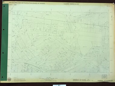
Map, Melbourne and Metropolitan Board of Works. Survey Division, MMBW, Yarra 2500 / 14.20. Montmorency, Sherbourne Road, 1977_06
Melbourne and Metropolitan Board of Works. Yarra 2500 [base map] 14.20. Montmorency, Sherbourne Road. Municipality of Diamond Valley 257 and Eltham 238. Prominent streets: Sherbourne Road, Karingal Drive and Calrossie Avenue. Features include Montmorency Station and Meruka Park.MMBW Map in 1:2500 [scale] series. Cream parchment with green tape reinforcing on edges and punched holes on left edge.mmbw, melbourne and metropolitan board of works, shire of diamond valley, montmorency - maps