Showing 824 items
matching eastern victoria
-
 Melbourne Tram Museum
Document - Report, The Parliamentary Standing Committee on Railways, "Report - Darling - Glen Waverley" and Outer Eastern Suburbs Connecting Railway, "Proposed Kew to Doncaster Electric Railway Extension", "Keilor and Bulla Districts Connecting Railway", "Proposed Expenditure under railway loan application Act - provision of connecting lines between Glenroy and Albion and Melbourne Goods Yard", 1923
Set of six reports from the "The Parliamentary Standing Committee on Railways" .1 - Report - 12 pages + plan printed stapled titled "Report - Darling - Glen Waverley" - includes connexion between Camberwell to Ferntree Gully and Oakleigh. Dated 30/6/1926 .2 - Report - 16 pages - "Report - Outer Eastern Suburbs Connecting Railway or Tramway (Doncaster, Templestowe and Warrandyte)"- 8/7/1925. .3 - Report - 24 pages - "Doncaster and Warrandyte Districts Connecting Railway" - 13/12/1928 - 2 copies held. .4 - Report - 12 pages - Proposed Kew to Doncaster Electric Railway Extension" - 4/12/1930 - 3 copies held - see also Reg Item 414. .5 - Report - 16 pages including plan - "Keilor and Bulla Districts Connecting Railway" - 1926. .6 - Progress Report - 12 pages including plans - "Proposed Expenditure under railway loan application Act - provision of connecting lines between Glenroy and Albion and Melbourne Goods Yard" - 30/6/1926. Includes a circular letter dated 24/7/1926, enclosing reports 5 and 6 from the Secretary of the Metropolitan Town Planning Commission. Note: All these documents are available as a pdf on the Parliament of Victoria website..2 - has "Manager" stamped and "Mr. Murdoch" and a date in the top right hand corner.. .3 - copy 2 - has "Mr. Lormer" as for .4trams, tramways, railways, parliament, darling, glen waverley, doncaster, templestowe, warrandyte, keilor, essendon -
 Melbourne Tram Museum
Document - Folder with papers, Folder of memos and directions, c1940
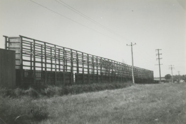
Folder of Memos and directions (htd3207i1> htd3207i8) - Air raid precautions, covering painting, respirators, sheds, tools, kits, shelters, stacks , blackouts, trenches, emergency, air raid shelters (htd3207i9> htd3207i16) - Accidents, covering accidents and derailments, (htd3207i17) - Bridges – inspection of Victoria St bridge (htd3207i18) - Cable tracks, covering tarring, patching, top dressing of cable tracks (htd3207i19> htd3207i21) - Cartage, covering hired trucks, cartage of wood blocks, spoil, sleepers (htd3207i22> htd3207i23) - Contracts, blank page (no image) - Councils, covering track opening, storm water drain, bad roads (htd3207i24) - Costs, covering maintenance costs, construction costs, wet weather (htd3207i25> htd3207i26) - Depots, covering inspections, storage, paving, telephones, mail (htd3207i27> htd3207i30) - Derailments, covering controls, reports (htd3207i31) - Drainage (htd3207i32) - Eastern Lines, covering loading platforms, crossovers, work orders (htd3207i33> htd3207i34) - Eastern Lines Reconstruction (htd3207i35> htd3207i37) - Eastern Line Maintenance (htd3207i38> htd3207i40) - Estimates (htd3207i41) - Employment (htd3207i42) - Footscray Lines (htd3207i43) - Instructions (htd3207i44) - Journals, covering Engineering Journal and magazines (htd3207i45) - Materials – General, covering frames & covers, unloading stores, packing plates, petrol allowance, ashes at Preston workshops, electrodes, sleepers (htd3207i46> htd3207i50) - Maintenance – General, covering loading platforms, inspections, work orders, paving (htd3207i51> htd3207i57) - Northern Lines, covering greasing of curves, crossovers, loading platforms (htd3207i58> htd3207i61) - Northern Lines – Reconstruction, covering crossings, welding machines (htd3207i62> htd3207i64) - Northern Lines – Maintenance, covering repairs, crossings, lifting programme, fencing, curves, track inspection, repairs (htd3207i65> htd3207i70) - New Lines (htd3207i71> htd3207i80) - Plant – General (htd3207i81> htd3207i94) - Plant – Concrete Mixers (htd3207i95) - Plant – Motor Vehicles (htd3207i96> htd3207i100) - Plant – Rollers (htd3207i101> htd3207i103) - Plant – Grinders (htd3207i104) - Plant – Grinders & Scrubbers (htd3207i105> htd3207i110) - Plant – Compressors and Tie Tampers (htd3207i111) - Plant – Cleaner Cars (htd3207i112> htd3207i114) - Plant – Loaders (htd3207i115) - Plant – Tools (htd3207i116> htd3207i117) - Plant – Miscellaneous (htd3207i118) - Per Way – General (htd3207i119> htd3207i121) - Public Utilities (htd3207i122> htd3207i123) - Reconstruction – General (htd3207i124> htd3207i126) - Railways (htd3207i127> htd3207i129) See \dbtext\hawthorn\photo_collections\3207_Folder for scanned images.trams, tramways, instructions -
 Melbourne Tram Museum
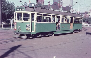
Slide, Keith Caldwell, 12/03/1960 12:00:00 AM
Agfa Colour slide, cardboard mount, by Keith Caldwell of 12 March 1960 - of SW6 875 at junction with Victoria Parade and Brunswick St (now St Vincent's Plaza) wit the Eastern Hill fire station in the background. Tram has adverts for Radio 3AW and ?.1 - hand stamped "12 Mar '60"trams, tramways, st vincent's plaza, victoria parade, west preston, route 10, sw6 class, tram 875 -
 Melbourne Tram Museum
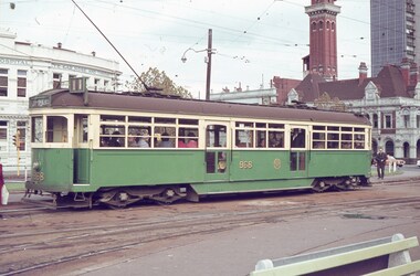
Slide, Keith Caldwell, 27/04/1964 12:00:00 AM
Agfa colour slide, blue / white plastic mount, photo by Keith Caldwell of W6 968 at the Victoria Parade junction with Gisborne St. Tram running a route 11, Spencer St service. In the background is the MFBB Eastern Hill fire station and the Eye and Ear Hospital. 27/4/1964In ink "SW car 27.4.64:"trams, tramways, route 11, victoria parade, gisborne st, mfbb, st vincent's plaza, w6 class, tram 968 -
 Melbourne Tram Museum
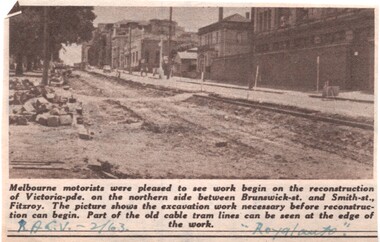
Newspaper, Royal Automobile club of Victoria (RACv), removal of the cable tram track in Victoria Parade, 1963 to 1971
Set of 8 newspaper clippings, mid 1960's concerning traffic control and congestion issues. .1 - Royal auto - 2/1963 - reporting on the removal of the cable tram track in Victoria Parade between Brunswick and Smith St, noting the old cable tram lines. .2 - Royal auto - 1/65 - Photo of Toorak Road Toorak with a tram and parked cars. .3 - Royal auto - 8/64 on Chapel St with W2 324 (route 77, City) showing the impact of parked cars at 8.45am and a motor car trying to squeeze past. .4 - Royal auto - 9/64, Burke Road Camberwell, showing the impact of parked cars and trams. Photo includes SW6 934 (Route 7 Camberwell) .5 - Royal auto - 8/67 - Swanston St near Collins St. .6 - View of Toorak Road, Hartwell, W2 641 (Spencer St, route 74) photo 8/68 by John Shingler. shows the shopping centre. .7 - Royal auto - 9/64 - Johnston St Collingwood and buses. .8 - MMBW Living City Winter 1971 of Kew Junction, peak hour inbound noting the new Eastern Freeway will reduce congestion.Extensive notes on the rear of the photo, see image i2trams, tramways, congestion, traffic control, racv, chapel st, toorak road, victoria parade, cable trams, w2 class, sw6 class, burke road, camberwell, route 77, route 7, swanston st, kew junction, route 74, hartwell, johnston st, buses, tram 324, tram 641, tram 934 -
 Melbourne Tram Museum
Document - Report, Australian Electric Traction Association (AETA), Set of 6 options for Doncaster Light Rail Line, 1991
... Victoria Park station Eastern Freeway/Doncaster Road 4 - Heavy rail... Victoria Park station Eastern Freeway/Doncaster Road 4 - Heavy rail ...In 1991, the Australian Electric Traction Association (AETA) produced 7 different options to provide public transport to the Doncaster area. See reference for background to the proposals. Six of the seven options have been found and collected. Each option provides a summary, costing based in a scope of works. The Options were: 1 - Light Rail to Doncaster Shoppingtown via Eastern Freeway/Doncaster Road 2 - Light rail to Mitcham Road/Springvale Road 3 - High-performance train to Doncaster Shoppingtown via Victoria Park station Eastern Freeway/Doncaster Road 4 - Heavy rail to Doncaster Shoppingtown via Eastern Freeway to Bulleen Road and underground to Shoppingtown 5 - Heavy Rail to Blackburn Road/George St East Doncaster 7 - Extension of the Camberwell Tram (72) along Burke Road from Cotham Road to Doncaster Road. Out of all the studies, nothing happened.Yields information about the early 1990s proposal to provide public transport to the Doncaster area.Set of 6 reports or options printed on A4 paper, stapled in top left hand corner.tramcars, tramways, aeta, new tramways, doncaster, railways, light rail -
 Melbourne Tram Museum
Document - Report, Parliament of Victoria, "Transcript of Evidence Public Works Committee - Melbourne - Eastern Railway Enquiry No. 2", 1974 - 1975
Foolscap duplicated reports or ""Transcript of Evidence Public Works Committee - Melbourne - 1974 - Eastern Railway Enquiry". Each set stapled in top left hand corner. 690.1 - First day - 46 pages - 14/8/1974 - includes evidence from Mr Kirby of MMTB 690.2 - Second day - 48 pages - 21/8/1974 - last page loose. 690.3 - 3rd day - 19 pages - 9/10/1974 690.4 - 4th day - 87 pages - 11/11/1974 - last three pages loose and damaged. 690.5 - 5th day - 27 pages - 27/11/1974 690.6 - 6th day - 66 pages - 9/12/1974 - last two pages loose 690.7 - 7th day - 34 pages - 5/2/1974 - first and last two pages loose and includes Mr. Kirby and others on trams. 690.8 - Report from the Parliamentary Public Works Committee - 25/6/1975 - 33 pages.Each set of documents stamped "AETA" and "AETA Public Transport Committee" on the front sheet.trams, tramways, victorian government, parliament, enquiries, mmtb, tramways, railways, doncaster -
 Melbourne Tram Museum
Document - Report, Parliament of Victoria, "Transcript of Evidence Public Works Committee - Melbourne - Eastern Railway Enquiry", 1972
Foolscap duplicated - Report from the Parliamentary Public Works Committee - 11/12/1972 - 18 pages, stapled in the top left hand corner.Stamped "AETA Public Transport Committee" on the front sheet and date "11/12/72" written in ink on top right hand corner.trams, tramways, victorian government, parliament, enquiries, mmtb, tramways, railways, doncaster -
 Melbourne Tram Museum
Document - Report, Melbourne & Metropolitan Tramways Board (MMTB), "Trial Installation of Barrier Kerbing, Nicholson Street - Fitzroy", Nov. 197
Report, manila covers, A4 paper, white comb binder, 30 pages, 1 photograph page of Nicholson St, looking north with a Z class tram in the distance, tables of traffic timing, looking at the impact of concrete barrier kerbs laid along the eastern side of Nicholson St Fitzroy between Alexandra Parade and Victoria Parade, 12 month trial. Report dated November 1976. Includes impact on traffic and tram services. 2nd copy added 23/10/2014.Marked number "85" in top right hand corner and stamped on cover and inside cover page "Discarded from PTC Library 22 Oct 1989". 2nd copy ex AETA marked "4E13" in top right hand corner of cover.trams, tramways, mmtb, nicholson st, fitzroy, traffic control -
 Bacchus Marsh & District Historical Society
Map, Plan of the second portion of the property of Messers Atkins and Clarke situate at Bacchus Marsh 1856
This plan of land allotments for sale indicates part of the property once owned by the Bacchus family in and around the township area of Bacchus Marsh. The Bacchus family sold their property in Bacchus Marsh to John Aitkins and Robert Nalder Clarke in March 1851. Aitkins and Clarke kept the property for a number of years until April 1856 when these allotments were put up for sale.This is a very early land sales plan for agricultural land close to the township of Bacchus Marsh. It therefore provides some clues as to how the early urban development of the township and agricultural development of the nearby area took place. Upon seeing the map in 1911 Bacchus Marsh Express newspaper editor Christopher Crisp wrote "The sale appears to have created the present township, which had a nucleus in earlier times further east", Express, 30 September, 1911, page 3.A single page paper plan showing allotments of land for sale. The subdivided land shown was owned by John Aitkins and Robert Nalder Clarke, but previously owned by the Bacchus Family and was in and around their Manor House (Mansion) property in Bacchus Marsh. This plan shows allotments in the second portion of land to be sold which was located east of the Manor House on the eastern side of the Lerderderg River. The land for sale was made up of 15 allotments. The plan is pasted into a bound volume containing 76 maps or plans in total. BMDHS Loc: AR/B12/S4 Bacchus Marsh Township and Nearby Districts Maps Volume In-house Digital copies: BMDHS, Computer Network: Maps\Bacchus Marsh Township and Nearby Districts Maps Volumebacchus marsh victoria maps, bacchus family, land sales, manor house bacchus marsh -
 Bacchus Marsh & District Historical Society
Map, Plan of Survey of Part of Crown Allotment 9, Parish of Korkuperrimul, 1890
This map documents a transfer of an allotment of land in Clarke Street Bacchus Marsh in 1890. Clarke Street is located on the eastern side of Bacchus Marsh not far from Main Street and Crook Street. It is now known as Candeloro Street. The map indicates J. Booth as the owner of the land and H. Simpson as the occupier. Next to this allotment is a an allotment of land owned by J. Elmore,Single page map showing Crown allotment 9, Parish of Korkuperrimul, County of Bourke. Scale 100 feet to inch. Part of a set of maps which are pasted into a bound volume containing 76 maps or plans in total. High resolution digital image stored on BMDHS computer network. At bottom of map: I hereby certify that I have made this survey expressly for the purpose of an application under the Transfer of Land Statute that this plan is correct. Barry B???, Lic. Surveyor, 16.10.90bacchus marsh victoria maps, clarke street bacchus marsh maps -
 Department of Energy, Environment and Climate Action
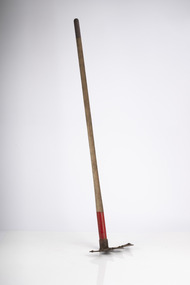
Rakehoe (McLeod Tool)
Bushfire perimeter rather than bushfire area is the main control problem for firefighters on the ground. A conundrum rapidly compounded by spot fires. A small 5 ha fire can be nearly 1 km around the perimeter. That's a long way to build a control line by hand in rough bush. Dry firefighting techniques by hand were mostly confined to “knocking down” or “beating out” the flames, as well as "digging out". Digging or raking a “mineral earth” trail down to bare dirt proved most effective in forest fuels which, unlike grass, tend to retain heat and smoulder. Early tools were whatever happened to be close at hand. They were simple and primitive and included shovels, slashers, axes, hoes, beaters and rakes. A cut branch to beat the flames was often the only thing available. Farming and logging tools, developed over centuries of manual labour, and readily available at local hardware stores came into use, but little thought was given to size, weight, and balance. For years foresters experimented with combination tools. In about 1952 fire beaters and other implements were being replaced with Rakuts. However, its believed the now common Rakehoe is an Australian variation of the American McLeod Tool which was developed in 1905 by forest ranger Malcolm McLeod of the Sierra National Forest. The late Athol Hodgson advised that predecessors, Reg Torbet who had been the Chief Fire Officer for the Forests Commission from 1948-1956, along with his QLD counterpart Clive Price, went in late 1951 as Australian delegates on a 10 week fire study tour of Nth America organised by the United Nations. They came back with a couple of McLeod tools from Canada. Cam MacLeod (different spelling) had been the Head of Fire Research for the Canadian Forest Service at the time and had supplied them. The tools were ideal for deciduous forests in the eastern provinces and Clive arranged to have them manufactured in QLD. The Rakho, as it was then spelled, was first issued to FCV crews 65 years ago in 1955-56. The American Pulaski had been trialled, but never found favour with Australian firefighters.Rakhoeforests commission victoria (fcv), hand tools, forest harvesting, bushfire -
 Lakes Entrance Historical Society
Photograph - Scallop Boats, Lakes Post Newspaper, 1/03/1993 12:00:00 AM
fishing boats at the Eastern Wharf aka Scallop Wharf prior to the opening of scallop season in which over sixty five boats are to take part fifty five being from Melbourne, Lakes Entrance Victoria. Crate limit of ten for the first fortnightBlack and white photograph showing fishing boats at the Eastern Wharf aka Scallop Wharf prior to the opening of scallop season in which over sixty five boats are to take part fifty five being from Melbourne, Lakes Entrance Victoriabusinesses, fishing industry -
 Department of Energy, Environment and Climate Action
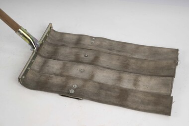
Fire beater (canvas)
Bushfire perimeter rather than bushfire area is the main control problem for firefighters on the ground. A conundrum rapidly compounded by spot fires. A small 5 ha fire can be nearly 1 km around the perimeter. That's a long way to build a control line by hand in rough bush. Dry firefighting techniques by hand were mostly confined to “knocking down” or “beating out” the flames, as well as "digging out". Digging or raking a “mineral earth” trail down to bare dirt proved most effective in forest fuels which, unlike grass, tend to retain heat and smoulder. Early tools were whatever happened to be close at hand. They were simple and primitive and included shovels, slashers, axes, hoes, beaters and rakes. A cut branch to beat the flames was often the only thing available. Farming and logging tools, developed over centuries of manual labour, and readily available at local hardware stores came into use, but little thought was given to size, weight, and balance. For years foresters experimented with combination tools. In about 1952 fire beaters and other implements were being replaced with Rakuts. However, its believed the now common Rakehoe is an Australian variation of the American McLeod Tool which was developed in 1905 by forest ranger Malcolm McLeod of the Sierra National Forest. The late Athol Hodgson advised that predecessors, Reg Torbet who had been the Chief Fire Officer for the Forests Commission from 1948-1956, along with his QLD counterpart Clive Price, went in late 1951 as Australian delegates on a 10 week fire study tour of Nth America organised by the United Nations. They came back with a couple of McLeod tools from Canada. Cam MacLeod (different spelling) had been the Head of Fire Research for the Canadian Forest Service at the time and had supplied them. The tools were ideal for deciduous forests in the eastern provinces and Clive arranged to have them manufactured in QLD. The Rakho, as it was then spelled, was first issued to FCV crews 65 years ago in 1955-56. The American Pulaski had been trialled, but never found favour with Australian firefighters.Fire Beater (canvas) 1930s designforests commission victoria (fcv), hand tools, forest harvesting, bushfire -
 Lakes Entrance Historical Society
Photograph - Broomes Maranui , Police Station Esplanade Lakes Entrance Victoria, 1938 c
Broomes Maranui Guesthouse with Police Station on the western side and the picture theatre on the eastern side. In foreground is the stone wall beside the lake, concrete path and picnic table beside the Esplanade Lakes Entrance Victoria. In foreground is the stone wall beside the lake, concrete path and picnic table beside the Esplanade Lakes Entrance Victoria. c1938 Black and white photograph of a postcard showing Broomes Maranui Guesthouse with Police Station on the western side and the picture theatre on the eastern side.accommodation, transport -
 Melbourne Tram Museum
Postcard, "A Glimpse of Collins St Melbourne Victoria", mid 1900's?
Image of Collins St looking west from Russell St with two cable trams in the view. Includes the Town Hall. Printed mid-1900's. Titled "A Glimpse of Collins St Melbourne Victoria". On the rear is a handwritten message and address - the removal of the stamp has obscured name. No printer details other than a number "B135/841" and in the bottom right hand corner "No. 8". Second copy in good order.Yields information about Collins St eastern end.Divided back postcard featuring a coloured image - Two copies held.trams, tramways, collins st, cable trams, town hall -
 Lakes Entrance Historical Society
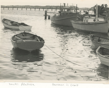
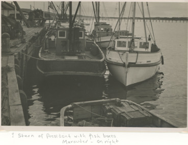
Photograph - fishing boats Alathea, Harveen, President and Marauder Lakes Entrance Victoria, Carpenter family, 1/05/1955 12:00:00 AM
fishing boats Alathea and Harveen moored on the inside berth at Eastern Wharf known as Harbecks Jetty with Cunninghame Arm Footbridge in distance Lakes Entrance Victoria. Plus another photo of 2 fishing boats Stern of President in foreground with fish boxes and Marauder on the right Black and white photograph taken of fishing boats Alathea and Harveen moored on the inside berth at Eastern Wharf known as Harbecks Jetty with Cunninghame Arm Footbridge in distance Lakes Entrance Victoria. Plus another photo of 2 fishing boatsfishing industry, boats and boating, jetties, waterways -
 Lakes Entrance Historical Society
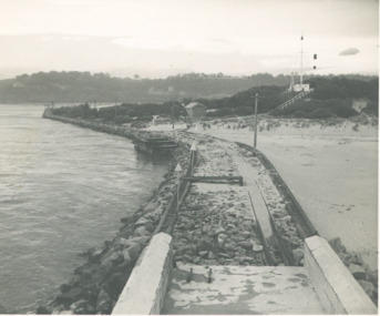
Photograph - Flagstaff above the entrance channel at Lakes Entrance Victoria c1952, L Carpenter, 1/11/1952 12:00:00 AM
eastern pier taken from the light at the southern end looking towards the entrance to Cunninghame Arm and showing the flagstaff above the entrance channel at Lakes Entrance Victoria c1952 Also a black and white photograph showing both entrance piers taken from the beach near the eastern pier Lakes Entrance Black and white photograph of the eastern pier taken from the light at the southern end looking towards the entrance to Cunninghame Arm and showing the flagstaff above the entrance channel at Lakes Entrance Victoria c1952 .. Also a black and white photograph showing both entrance piers taken from the beach near the eastern pier Lakes Entrance waterfront, boats and boating, jetties, gippsland lakes -
 Ballarat Tramway Museum
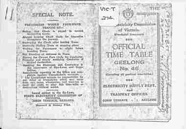
Ephemera - Photocopy, State Electricity Commission of Victoria (SECV), "Official Time Table Geelong No. 46", c1951
Photocopy of the Geelong Timetable, No. 46, c1951 giving details of the fares, transfers, luggage or parcels, lost property, times of each tram on the Newtown, West Geelong, East Geelong, Chilwell, Eastern Park, Belmont and North lines. Note: Sheets may not be in the same order as the printed versions due to the photocopying method. See items 5357 and 5629 and 8552 for other versions. Yields information about the operation of the Geelong tramway system.Photocopy - 17 A4 sheets of the "Official Time Table Geelong No. 46" on heat sensitive paper.tramways, trams, geelong, timetable, operations -
 Lakes Entrance Historical Society
Photograph, Carpenter family, Fishing boats Marauder and President, Lakes Entrance, 1/05/1955 12:00:00 AM
at Eastern Wharf aka Harbecks Jetty Lakes Entrance VictoriaBlack and white photograph of fishing boats Marauder and President on the outside berth jetties, waterways, boats and boating, fishing industry -
 Lakes Entrance Historical Society
Book, Victoria University Institute for Sustainability and Innovation, Breaming with Knowledge, 2010
A program for the 2-day conference on the ecology and management of the Gippsland Lakes and other coastal lagoons in south-eastern Australia.waterways, conservation, climate -
 Ballarat Tramway Museum
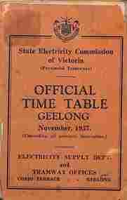
Ephemera - Timetable, State Electricity Commission of Victoria (SECV), "Official Timetable Geelong", November 1937
Gives details of the fares, transfers, luggage or parcels, lost property, times of each tram on the Newtown, West Geelong, East Geelong, Chilwell, Eastern Park, Belmont,, North, Dated Nov. 1937. Has adverts for SEC domestic appliances eg toasters, refrigerators and hot water.Yields information the 1937 tramway services in Geelong and SECV advertising domestic appliances.Printed booklet - was centre stapled - part of two timetables included within one cover. One loose sheet.secv, tramways, geelong, timetables -
 Lakes Entrance Historical Society
Photograph - large maize crib Bruthen Victoria, 1990 c
possibly last one still remaining in district.Black and white photograph of large maize crib Situated on eastern side of main road from Bruthen to Mossiface Victoriafarming, agriculture -
 Ballarat Tramway Museum
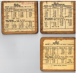
Document - Table Cards (Sheets), State Electricity Commission of Victoria (SECV), Geelong Trams Runs, 1950's
Table cards gives details for the Motorman and Conductor, starting times, meal times, relief and taken by details. Not known when made - 1950's? .1 - Run 5- Ryrie St - Belmont and North .2 - Run 12 - Ryrie St - Belmont and North with further details on rear. .3 - Run 33 - City - Eastern Park and Newtown for Motorman and Conductor See also Reg Item 3155, 8134 and 9690 for other examples and 8135 for a Bendigo example.Set of three Typed table card or run card, for Geelong Trams Runs glued and varnished onto a sheet of three ply timber - plywood boards. trams, tramways, secv, forms, timetables, geelong -
 Ballarat Tramway Museum
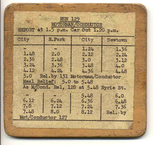
Document - Table Cards (Sheets), State Electricity Commission of Victoria (SECV), Geelong Trams Run 129, 1950's
Table card gives details for the Motorman and Conductor, starting at 125, working Eastern Park and Newtown. Gives meal times, relief and taken by details. Not known when made - 1950's? See also Reg Item 6270, 8134 and 9690 for other examples and 8135 for a Bendigo example.Typed table card or run card, for Geelong Trams Run 129 glued and varnished onto a sheet of three ply timber - plywood. trams, tramways, secv, forms, timetables, geelong -
 Bacchus Marsh & District Historical Society
Map, Plan of the property of Messers Atkins and Clarke to be sold at the Mansion, Bacchus Marsh 19th April 1856. Copy 1
This plan of land allotments for sale indicates the property once owned by the Bacchus family in and around the township area of Bacchus Marsh. The Bacchus family sold their property in Bacchus Marsh to John Atkins and Robert Nalder Clarke in March 1851. Atkins and Clarke kept the property for a number of years until April 1856 when these allotments were put up for sale.This plan is almost identical to another copy held by the Bacchus Marsh and District Historical Society, VC Record 452, BMDHS collection). This plan, VC Record 707 Copy 1, contains a little more detail overall than VC Record 452 Copy 2, such as who did the survey work for the plan (R.C. Bagot) and who the selling agents were, (W.M. Tennent), and on the right side of the plan near the Lerderderg River is indicated the general area for a second parcel of land from this sale which is to be sold. There is also a compass illustration indicating north and south compass points.This is a very early land sales plan for the township of Bacchus Marsh and it therefore provides some clues as to how the early urban development of the township took place. Upon seeing the map in 1911 Bacchus Marsh Express newspaper editor Christopher Crisp wrote "The sale appears to have created the present township, which had a nucleus in earlier times further east", Express, 30 September, 1911, page 3.A single page paper plan showing allotments of land for sale. The subdivided land shown was owned by John Atkins and Robert Nalder Clarke, but previously owned by the Bacchus Family and was in and around their Manor House (Mansion) property in Bacchus Marsh.There are 5 portions of land further divided into numerous small portions. The land for sale is bounded by the present day streets of Main Street, Young Street, McFarland Street, Morton Streets, Crook Street, and part of the eastern section extends to the Lerderderg River. Scale: 8 chains to 1 inch The plan is pasted into a bound volume containing 76 maps or plans in total. BMDHS Loc: AR/B12/S4 Bacchus Marsh Township and Nearby Districts Maps Volume In-house Digital copies: BMDHS, Computer Network: Maps\Bacchus Marsh Township and Nearby Districts Maps VolumeHeading: Plan of the first portion of land. The property of Messers Atkins and Clarke situate at Bacchus Marsh. To be sold by W.M. Tennent & Co. at the Mansion on the Ground on Saturday the 19th April 1856. Below heading: Jas Ferguson, Lithographer On upper right side: Subdivided by R.C. Bagot London and Liverpool Chambers, Melbourne. 'Thos Taubman'. Post Office Stamp: BACCHUS MARSH VICTORIA MY 6, 63bacchus marsh victoria maps, bacchus family, land sales, manor house bacchus marsh -
 Lakes Entrance Historical Society
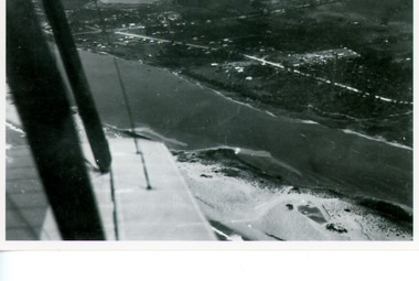
Photograph - Lakes Entrance, Bulmer H D, Whiters Camp Park, 1940c
Black and white copy photograph of aerial view of eastern approach, showing Princes Highway, Whiter's Camp Park, sandy outer barrier beside Cunninghame Arm, distant view of North Arm. Lakes Entrance Victoriawaterways, township -
 Flagstaff Hill Maritime Museum and Village
Photograph - Historical, building, Late 19th to early 20th century
The black and white photograph depicts the Lady Bay Lighthouse Complex at Flagstaff Hill, Warrnambool. It was opened on this site in 1871. From left to right, the Chartroom (previously named the Store), Upper Lighthouse, Flagstaff, Lighthouse Keeper's Quarters. The bluestone buildings are facing North on Merri Street. The Harbour Pilot's Lodgings were on the east of the Complex. There are two unknown male figures standing in front of the light-coloured picket fence that encompasses the Complex. The photograph is mounted on card. WARRNAMBOOL'S LADY BAY LIGHTHOUSES In the 1800s ships sailing from England to Australia began to use Bass Strait as a faster route to Melbourne. Small navigation errors led to many tragic shipwrecks. From 1848 lighthouses were operating along Victoria’s southern coast as a guide for sailors. Coastal towns such as Warrnambool grew and the exchange of trade and passengers was of great benefit. However, the uncertain weather changes, relatively shallow waters and treacherous, hidden rocky reefs were not really suitable for a Harbour and in the 1840s and 1850s, there were many shipwrecks in the area, with some even stranded in its Lady Bay harbour. A jetty was built in 1850 and a flagstaff to guide seafarers was placed up high on what became known now as Flagstaff Hill. In November 1857 the Victorian Government recommended that Warrnambool Harbour had beacons and two lighthouses to guide vessels into and out of the Harbour safely. The white light of the Middle Island lighthouse was to be used for the first time on September 1, 1859. The red light of the Beach Lighthouse, a wooden obelisk structure, was first operated on March 25, 1860, but in 1868 this light was ‘discontinued’ due to it being too low. Melbourne’s Department of Public Works decided to relocate the Middle Island Lighthouse Complex - Lighthouse, Keeper’s Quarters, Privy, Store Room and even water tanks - to Flagstaff Hill. The lower obelisk was shortened, and a protruding gallery, railing, and external ladder were added, and the light from the Beach Lighthouse. A green guiding light was erected on the end of the jetty. The transfer of the Complex began in March 1871. Each shaped stone of the lighthouse was carefully numbered, removed then reassembled on Flagstaff Hill. In 1872 the well was sunk behind the Lighthouse Keeper’s Cottage. The Keepers and families had left Middle Island in April and moved to Flagstaff Hill in October 1871. Vessels entering Lady Bay align the Upper and Lower Lighthouse towers during the day and the lights at night. The Upper Lighthouse is a round tower, and the Lower Light is square. The Lighthouses were categorised as harbour lights rather than coastal lights, so they remain under the control of the Victorian Government’s Ports and Harbours section. The lights were originally powered by oil, then acetylene gas, later by electricity, and then converted to solar power in 1988. In 1993 the solar panel was replaced by a battery charger. A decision was made in 1936 to replace the lighthouses’ lights with unattended lights that no longer required Keepers and Assistants. At least 29 Keepers had attended to the lighthouse from its opening in 1859 to when the last official Lightkeepers left In April 1916. The Warrnambool Harbour Board rented out the Quarters from 1916 to 1936. The Board closed down but the rentals continued with other unknown landlords. In the 1970s the Flagstaff Hill Planning Board was set up under the chairmanship of John Lindsay. The Board was to make recommendations to the Warrnambool City Council regarding using the buildings and the rest of the Crown Land on the site. The Flagstaff Hill Maritime Village opened in 1975 and began renovating the Cottage in stages, during which time evidence of a 1920s fire was found in the eastern section of the cottage. Additions of a porch on the west and a washroom on the east were made in the 1980s. The western part of the building is now a Shipwreck Museum and the east has returned to a late 19th-century Lighthouse Keeper’s cottage and includes the screen made by Assistant Lighthouse Keeper Thomas Hope in the late 19th century. He served as Assistant Keeper in Warrnambool for two periods.The Warrnambool Lighthouse Complex is now listed on the Victorian Heritage Register, H1520, for being of historical, scientific (technological) and architectural significance to the State of Victoria. The Complex is significant as an example of early colonial development. The buildings are significant for their connection with the important navigational function of the Lighthouses, a function still being performed to this day. The buildings are also significant as an example of structures designed and works carried out by the Public Works Department in Victoria in the mid-to-late 19th century. The structures still stand strong. Photograph; Warrnambool Lighthouse Keeper's cottage, lighthouse, flagstaff and chartroom at Flagstaff Hill, and a light-coloured picket fence with gate. Two male figures are in front of the fence. Black and white print glued to a yellow card. The inscription is indecipherable. The right side of the cottage has a built-in, enclosed addition.Ink stamped in lower right hand corner, too faded to be legible.flagstaff hill, flagstaff hill maritime museum, flagstaff hill maritime village, warrnambool, maritime museum, shipwreck coast, lighthouse keeper's cottage, lighthouse residence, lighthouse, chart room, quarters, privy, middle island, beach lighthouse, obelisk, lighthouse complex, lady bay complex, warrnambool port, warrnambool harbour, lady bay, keepers, lighthouse keeper, upper lighthouse, lower lighthouse, assistant keeper, ports and harbours, cottage -
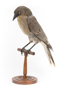 The Beechworth Burke Museum
Animal specimen - Grey Currawong, Trustees of the Australian Museum, 1860-1880
This specimen is a Grey Currawong. There are six subspecies of Grey Currawongs and they can sometimes interbreed with other species of Currawong leading to a divergent series of appearances amongst the species. The species can be found in the south western to south eastern parts of Australia, including in Tasmania. It is an endangered species in the Northern Territory although the reasons why are not yet known. They prefer a wide range of habitats including coastal to arid and can also be occasionally found in suburban areas. This specimen was misidentified as a Grey Crow in original catalogue records and is part of a collection of almost 200 animal specimens that were originally acquired as skins from various institutions across Australia, including the Australian Museum in Sydney and the National Museum of Victoria (known as Museums Victoria since 1983), as well as individuals such as amateur anthropologist Reynell Eveleigh Johns between 1860-1880. These skins were then mounted by members of the Burke Museum Committee and put-on display in the formal space of the Museum’s original exhibition hall where they continue to be on display. This display of taxidermy mounts initially served to instruct visitors to the Burke Museum of the natural world around them, today it serves as an insight into the collecting habits of the 19th century.This specimen is part of a significant and rare taxidermy mount collection in the Burke Museum. This collection is scientifically and culturally important for reminding us of how science continues to shape our understanding of the modern world. They demonstrate a capacity to hold evidence of how Australia’s fauna history existed in the past and are potentially important for future environmental research. This collection continues to be on display in the Museum and has become a key part to interpreting the collecting habits of the 19th century.This Grey Currawong has mainly grey plumage with a white tail tip and darker undercarriage. It has yellow irises, made of glass, and brown claws. The bill is dark in colour. This specimen has been placed upon a wooden mount in a downwards facing position. It has a paper tag attached to its right leg.16a / Grey Cro [torn] / See Cat / [torn] /axidermy mount, taxidermy, animalia, burke museum, beechworth, australian museum, skin, reynell eveleigh johns, bird, grey crow, grey currawong, currawong -
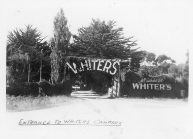 Lakes Entrance Historical Society
Postcard - whiters camp park, Bulmer H D, 1945c
One of a set of eight small format postcardsBlack and white small format postcard taken from road, showing entrance, treed with signage above double gated driveway at Whiters Camp Park. Sign on fence at eastern side of gateway, Still Australia's Best. Lakes Entrance VictoriaEntrance to Whiters Camp Parkresort, tourism, recreation