Showing 13341 items
matching genealogy-german-research
-
 Tatura Irrigation & Wartime Camps Museum
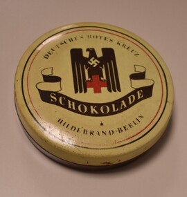
Tin, Chocolate, 1939-1945
Else-Lore and her mother Else Oertel were German internees in Camp 3A from 1940-1945. The German Red Cross sent items to the internees in the camps and this tin of chocolate was one of the items given to the Oertel family. Else-Lore Hukins donated the item, which she describes as a 'treasured item'.Round metal tin with plastic-wrapped cake of chocolate inside. Chocolate has Hildebrand inscribed in centre with picture possibly of two knights on horseback. Tin has cream/tan lid with dark brown base. Lid has picture of German eagle in brown, with a cream swastika on its chest, standing on a red cross.(On lid): Deutsches rotes kreuz (German Red Cross)/ Schokolade (chocolate)/ Hildebrand - Berlintatura, ww2, camp 3, internment, internee camps, items, german red cross, else-lore hukins, oertel family, else oertel -
 Eltham District Historical Society Inc
Slide, Maroondah Aqueduct, Research, Victoria, 22 Mar. 1981
An inspection tour of the Maroondah Aqueduct was undertaken by the Shire of Eltham Historical Society on Sunday, March 22nd, 1981, commening where the aqueduct crosses Main Rd., Research, just below Eltham College. The Maroondah Aqueduct was part of Melbourne’s water supply system. It carried water over the 66 km from the Maroondah Reservoir on the Watts River at Healesville to the Preston Reservoir. Of this length, 41 km were open channel, 10 km, tunnel through hills and 15 km in 14 inverted siphons across stream valleys. The route of the aqueduct is north of Tarrawarra and Yarra Glen, along the Yarra escarpment south of Christmas Hills and crossing Watsons Creek into the present Shire of Eltham near Henley Rd. The eastern part of the route lies entirely within the former boundaries of the shire. The aqueduct passes south of Kangaroo Ground to Research and crosses the Diamond Creek by siphon at Allendale Rd., Eltham North. It then extends to Reservoir via St. Helena, Greensborough North and Bundoora. Water first flowed through the aqueduct in February 1891 when it was fed by a diversion weir on the Watts River. Records of the building of the aqueduct indicate that it was a significant construction achievement. The present Maroondah Reservoir was completed in 1927 and the aqueduct was enlarged at that time to take increased flows. About 1971 the section of the aqueduct through and north of Research was replaced by a large pipe and that section of the channel is now unused. The channel has remained largely intact (unlike sections at Greensborough and Bundoora where long lengths of the disused aqueduct have been demolished or filled in). The M.M.B.W. relinquished control of the disused aqueduct reserve which is crown land and the Shire of Eltham took control of this section of the reserve as a linear park. The Maroondah Aqueduct is considered to be an important historic structure, not just to the local area but to the metropolitan area generally. It is considered important to preserve substantially intact long lengths of the disused aqueduct, together with its bridges and other associated structures. 35 mm colour positive transparency (1 of 5) Mount - Agfachrome Agfa CS System black 8 dotsactivities, heritage excursion, maroondah aqueduct, research (vic.), shire of eltham historical society -
 Bendigo Historical Society Inc.
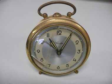
Functional object - ALARM CLOCK, 1960's
Cream tin plate German alarm clock, silvered dial with black and gold hands & numerals Brass bezel, legs and handle, convex glass.Schuler made in Germanyhorology, clocks, alarm -
 Lakes Entrance Historical Society
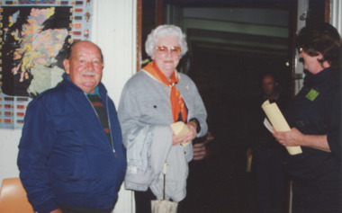
Photograph - Genealogical Group , Lakes Entrance Victoria, Babs Harris, 11/03/1994 12:00:00 AM
Genealogical Group Display Opening held at the Mechanic Hall showing Ian and Edith Bulmer and Jan Grant Lakes Entrance Victoria. Also two other colour photographs taken the same day numbers 04108.3 and 04108.4 size 10 x 15 cm, plus a black and white photograph of Marion Holding and Margo Kirby number 04108.5 size 8 x 11 cmColour photograph taken at the Genealogical Group Display Opening held at the Mechanic Hall showing Ian and Edith Bulmer and Jan Grant Lakes Entrance Victoriagenealogy, clubs -
 Eltham District Historical Society Inc
Photograph - Aerial Photograph, Landata, Research, Vic, Apr. 1972
Centred on present day Maroong Drive, Research bounded by Allendale Road to north, Thompson Crescent to south, Eltham College to east and Parsons Road to west. Historic Aerial Imagery Source: Landata.vic.gov.au Aerial Photo Details: Project No :985 Project : MELBOURNE 1972 Run : 26 Frame : 193 Date : 04/1972 Film Type : B/W Camera : RC10 Flying Height : 5700 Scale : 9600 Film Number : 2636 GDA2020 : 37°42'04"S, 145°10'33"E MGA2020 : 339187, 5825794 (55) Melways : 22 F1 (ed. 42)aerial photo, neil webster collection, 1972-04, allendale road, eltham, eltham barrel, eltham college, maroong drive, melway 22f1, parsons road, research (vic.), thompson crescent -
 Federation University Historical Collection
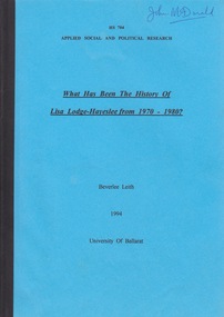
Document - Document - Research Paper, University of Ballarat: Applied Social and Political Research; "What has been the History of Lisa Lodge-Haveslee from 1970 - 1980?" Beverlee Leith, 1994
Lisa Lodge Girls' Hostel, Ballarat, was established in 1970 and was run by a committee of women. All the women were Honorary Probation Officers. It provided residential care for eight adolescent girls at a time. Lisa Lodge was located in a number of different properties around Ballarat. The Hostel closed in 1994. Some time after this, Hayeslee House (another home in Ballarat, run by the same committee) became known as Lisa Lodge. This Committee managed a number of institutions in the Ballarat region. Another institution to start in 1994 was Berry Street Incorporated that amalgamated with Sutherland Child, Youth and Family Services. In 2009 Berry Street was the largest independent child and family welfare organisation in Victoria. In 2012 Lisa Lodge merged with Berry Street to strengthen Berry Street's services provided in the Grampians Region of Victoria. This research paper explores the first ten years of Lisa Lodge. Of note is Lisa Lodge was set up by a group of women for a group of women. It depended on donations to continue operating. Data was collected through interviews and analysing minutes of meetings. Correspondence and newspaper clipping were also used. This is a historical report so there are no recommendations. Before proceeding with this project, Beverlee Leith had to seek approval from the Human Research Ethics Committee, University of Ballarat. This was granted at their meeting on Thursday, 11 August 1994. Dr John McDonald, School of Humanities and Social Sciences was supervisor.Booklet of 51 pages. Blue paper cover front and back. Pages are glued together and have black binding. Name John McDonald written in biro - top right corner of front cover. Date of item is 1994honorary probation officers, ballarat, adolescent girls, hayeslee house, minutes of meetings, correspondence, berry street, interviews, beverlee leith, human research ethics committee, school of humanities & social sciences, dr john mcdonald, lisa lodge girls' hostel, residential care -
 8th/13th Victorian Mounted Rifles Regimental Collection
Photograph - WWI aircraft in desert
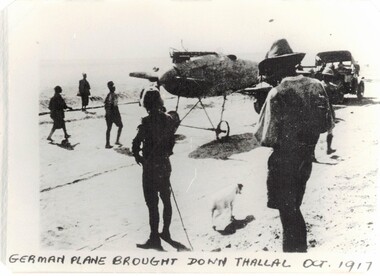
The 8th Light Horse Regiment AIF was raised at Broadmeadows Victoria in September 1914 under the command of Lieutenant Colonel Alexander White and formed part of the 3rd Light Horse Brigade. The regiment served at Gallipoli where in a courageous but ill-fated charge at the Nek on 7 August 1915 it suffered horrendous casualties including Lieutenant Colonel White. Rebuilt in Egypt under the command of Lieutenant Colonel Leslie Maygar VC the regiment went on the serve throughout the Middle East Campaign. Colonel Maygar died of wounds at Beersheba when the regiment was attacked by enemy aircraft while waiting to follow up the successful charge of the 4th LH Brigade on 30 October 1917. The 8th Light Horse AIF was disbanded in 1919, but soon after re-raised as the 8th (Indi) Light Horse in the Citizen Military Forces, superseding 16th (Indi) Light Horse. Black and white photograph of spectators round a downed German aircraft October 1917.German plane brought down Thallal Oct 1917world war one, wwi, aircraft, plane, thallal -
 Eltham District Historical Society Inc
Photograph - Aerial Photograph, Landata, Research, Vic, Feb. 1956
Centred on present day Thompson Crescent, Research bounded by Maroondah Aqueduct to north, Thompson Crescent and Nyora Road to south, Bells Hill Road to east and Eucalyptus Road to west Historic Aerial Imagery Source: Landata.vic.gov.au Aerial Photo Details: Project No :250 Project : MELBOURNE OUTER SUBURBS PROJECT Run : 19 Frame : 6 Date : 02/1956 Film Type : B/W Camera : EAG9 Flying Height : 10000 Scale : 12000 Film Number : 1176 GDA2020 : 37°42'38"S, 145°11'02"E MGA2020 : 339927, 5824736 (55) Melways : 22 H4 (ed. 42)aerial photo, 1956-02, neil webster collection, bells hill road, eltham, eucalyptus road, maroondah aqueduct, melway 22h4, nyora road, research (vic.), thompson crescent -
 Eltham District Historical Society Inc
Photograph - Aerial Photograph, Landata, Research, Vic, Apr. 1963
Centred on present day Thompson Crescent and Nicholson Close, Research bounded by Maroondah Aqueduct to north, Nyora Road to south, Eltham College to east and Eltham Gateway Hotel to west. Historic Aerial Imagery Source: Landata.vic.gov.au Aerial Photo Details: Project No :486 Project : MELBOURNE (1963) PROJECT Run : 5 Frame : 61 Date : 04/1963 Film Type : B/W Camera : RC8 Flying Height : 5100 Scale : 9600 Film Number : 1805 GDA2020 : 37°42'24"S, 145°10'06"E MGA2020 : 338528, 5825143 (55) Melways : 22 D3 (ed. 42)aerial photo, neil webster collection, eltham, 1963-04, eltham college, eltham gateway hotel and conference centre, maroondah aqueduct, melway 22d3, nicholson close, nyora road, research (vic.), thompson crescent -
 Eltham District Historical Society Inc
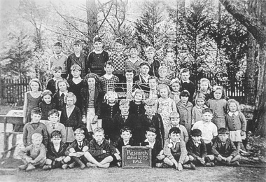
Photograph, Students, Research State School No. 2959, Research, Vic, 1942
1942, class photo, research (vic.), research state school no. 2959 -
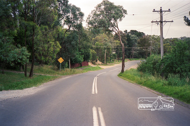
 Eltham District Historical Society Inc
Photograph (Item) - Negative, Jocelyn Zepter-Trevor, Main Road at Research-Warrandyte Road, Research, 1988
Jocelyn Zepter-Trevor 1988 Entrant No. 69 Ref: Series 34, Item 24 The images in this record were not selected for inclusion. SHIRE OF ELTHAM COMMUNITY PHOTOGRAPHIC SURVEY Photography is an artform which many of us practice, sometimes purely for artistic pursuit, sometimes to record the people and events in our lives. In 1988, as part of a local Bicentennial project, the Shire of Eltham conducted the Eltham Community Photographic Survey. Up to 100 entries were to be selected by a panel of photographers for entry into the Eltham Photographic Survey Exhibition. Entries had to be submitted by May 13, 1988. Entrants whose images were selected for the exhibition were contacted and requested to further submit an entry form providing entrant’s name, area of residence, age, and proposed captions. These details were then used to produce labels for the exhibition mounts. Where negatives had not been supplied, these were requested to support the display of printed enlargements mounted on 10” x 8” cardboard. The mounted prints were made available post exhibition for sale at $8.50 each for colour prints and $7.00 for B&W prints. Residents in the Shire were invited to collect a free roll of film and take a photograph of what they either liked or did not like about the area. A total of 160 entrants submitted multiple entries for the exhibition. Of those selected for exhibition, entrants ranged in age from 9 to 70 years. All custom colour and black and white printing for the exhibition was completed by Wattle Studios of Eltham. The Eltham Photographic Survey was jointly auspiced by the Shire of Eltham and Wattle Studios, of 953 Main Road, Eltham. The project was greatly assisted by: • David McRitchie, Media Studies Lecturer Victoria College, Rusden Campus. • Ian and Annette Toohill of Wattle Studios • Tracy Naughton, Eltham Community Arts Officer • Neville Emerson Pty. Ltd. • Superior Press, Eltham • Kodak Australasia Pty. Ltd. • Agfa Gevaert Ltd. • Townsend Colourtech Pty. Ltd. • The Australian Bicentennial Authority • Eleanor Bowers, Secretary, Eltham Arts Council The exhibition was placed on display in the Woolworths Arcade, Eltham between Monday June 6th and Saturday June 11, 1988. It was also intended to hold the exhibition at a venue in the Shire’s North Riding from Monday, June 20 to Friday June 24. It was then displayed at the Were Street Theatre, Montmorency from Friday, June 24 to Thursday, July 7. Series 34: Eltham Community Photographic Survey 1988 - Prints & Documentation Series consists of 117 photographs of Shire scenes taken by members of the community. Items I - 41 are larger photographs mounted on card, which were exhibited. Items 42 - 117 are unmounted copies, alternative takes and other entries. Corresponding negatives contained in Series 35: Eltham Community Photographic Survey 1988 – Negatives which consists of 267 colour and B&W negatives and one colour slide of Shire scenes taken by members of the community. The negatives are arranged by the entrant number of the photographer. The Eltham Community Photographic Survey collection is significant to the local community as it was curated by the local community - ordinary people of all ages - representing what they liked and did not like in the area where they lived. It represents an unfiltered representation of the Shire of Eltham as it was in 1988. It also represents one of many projects as part of the national programme of events and celebrations to commemorate the bicentenary. It is a time capsule of life in the 1980s of this urban and rural municipality in Melbourne's north. shire of eltham archives, bicentennial project, eltham community photographic survey, film - agfa xr 100 i, jocelyn zepter-trevor, scan - 35mm negative, series 35, main road, research (vic.), research-warrandyte road -
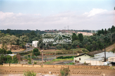
 Eltham District Historical Society Inc
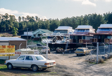
Slide - Photograph, Research Industrial Estate, 1607 Main Road, Research, c.May 1988
35mm colour positive transparency (1 of 23) Mount - Kodak EktachromeProcess Date MAY 88Mboat building, research industrial estate, main road, research (vic.) -
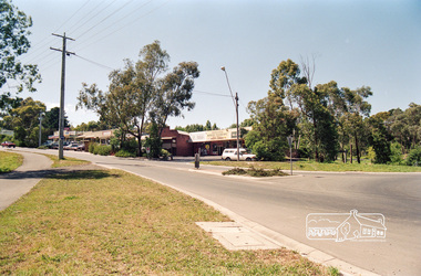 Eltham District Historical Society Inc
Photograph, Research Shops looking southeast from intersection of Main Road and Research Warrandyte Road, c.1992, 1992c
Roll of 35mm colour negative film, 7 strips Fuji 100main road, research (vic.), research warrandyte road -
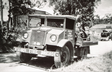 Eltham District Historical Society Inc
Photograph, Neil Ploog, Ford Blitz water tanker, Research Fire Brigade, Ingrams Road, Research, 1954, 1954
Early 1954 near present day site of Eltham Little TheatreThe Reynolds family were early settlers in Research.Black and white photograph mounted in an album, the Reynolds/Prior Photograph Collection, this being one of 53 reproduced black and white images of early Eltham. Also available digital colour variantThe Reynolds/Prior Photograph Collection, Presented to the Eltham District Historical Society, 14 June 2006 by Ross McDonald. A second copy was also presented to the Andrew Ross Museum, Kangaroo Groundreynolds prior collection, research (vic.), research fire brigade, fire brigades -
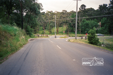 Eltham District Historical Society Inc
Photograph, Research-Warrandyte Road, Research
Roll of 35mm colour negative film, 4 stripsFuji 100main road, research (vic.), roundabouts, research warrandyte road -
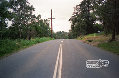 Eltham District Historical Society Inc
Photograph, Research-Warrandyte Road, Research
Roll of 35mm colour negative film, 4 stripsFuji 100main road, research (vic.), research warrandyte road -
 Eltham District Historical Society Inc
Photograph, Research-Warrandyte Road, Research
Roll of 35mm colour negative film, 4 stripsFuji 100main road, research (vic.), research warrandyte road -
 NMIT (Northern Melbourne Institute of TAFE)
Report: Making research work for vocational education, Papers & Proceedings of the Victorian Training Research Conference 28-29 April 1994 Holmsglen College of TAFE
One volume of various pagings published by the Office of Training and Further Education, Victoria, June 1994 and edited by Damon Anderson. ISBN 073064619X.victorian training research conference, state training board, reports -
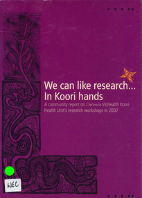 Victorian Aboriginal Corporation for Languages
Book, Onemda VicHealth Koori Health Unit, We can like research -- in Koori hands : a community report on Onemda VicHealth Koori Health Unit's research workshops in 2007, 2008
B&w photographsindigenous health, health and hygiene, koori community workshops, health research, onemda, njernda aboriginal corporation, vaccho, wathaurong aboriginal cooperative, gippsland and east gippsland aboriginal cooperative -
Moorabbin Air Museum
Book (Item) - Aeronautical Research Laboratory 1939 - 1989 , 50 Years Of Research And Development For Australia's Defence
-
University of Melbourne, Burnley Campus Archives
Plan - Photocopy, Plan - Additions to Plant Research Laboratory (1) , Extension to Plant Research Laboratory for the Department of Agriculture, Burnley Gardens (2 & 3), 1953
University of Melbourne Property and Services has better copies Photocopies, reduced in size, of original plans. Signed by Dept of Public Works, Chief Architect. (1) and (2) dated 14.08.1953 (1) UCB.2.123 North Elevation, Perspective Sketch, Plan. (2) UCB.2.142₃ Floor plan. (3) UCB.2.157.0, dated 26.11.53, South Elevation Front (North) Elevation, West Elevation, Plan, Sections ₂. University of Melbourne - Property and Services has a better copy.plant research, laboratories -
 Eltham District Historical Society Inc
Negative - Photograph, View from Main Road, Research towards Maroondah Aqueduct Trail showing mudbrick manufacture, Research Industrial Estate, 1991
Roll of 35mm colour negative film, 9 strips olour print 10 x 15 cmFuji HG 200 CA-1main road, maroondah aqueduct, maroondah aqueduct trail, mudbrick, mudbrick construction, research (vic.), research industrial estate -
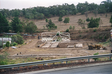
 Eltham District Historical Society Inc
Negative - Photograph, View towards Main Road, Research from Maroondah Aqueduct Trail showing mudbrick manufacture, Research Industrial Estate, 1991
Roll of 35mm colour negative film, 9 strips Colour print 10 x 15 cmFuji HG 200 CA-1main road, maroondah aqueduct, maroondah aqueduct trail, mudbrick, mudbrick construction, research (vic.), research industrial estate -
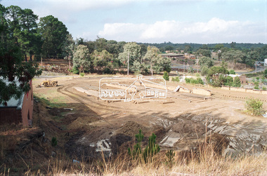
 Eltham District Historical Society Inc
Negative - Photograph, View towards Main Road, Research from Maroondah Aqueduct Trail showing mudbrick manufacture, Research Industrial Estate, 1991
Eltham Little Theatre in centre distance and new housing estate development off Reynolds Road in distanceRoll of 35mm colour negative film, 9 strips Colour print 10 x 15 cmFuji HG 200 CA-1eltham little theatre, houses, main road, maroondah aqueduct, maroondah aqueduct trail, mudbrick, mudbrick construction, research (vic.), research industrial estate, reynolds road -
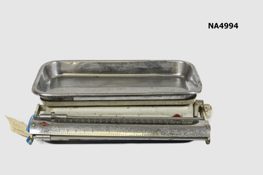 Whitehorse Historical Society Inc.
Functional object - Kitchen Scales, c: 1950s
Donanted by Robert Petty Family of Petty's Orchard in Doncaster/Templestowe area. The scales were owned by Gertrude Petty (nee Pye)Kitchen scales - imperial measurement, balance scale , 25lb capacity. Enamel Painted, chrome with chrome tray. Krups brand. Made in Germany.Krups Perla, made in Germanydomestic items, weighing -
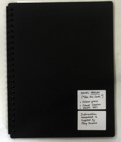 Orbost & District Historical Society
folder, Daniel Moylan (Dan the Cook), October 2012
This research record was part of a thesis that Mary Doland was preparing.This record is an excellent research tool for the study of the Indigenous history of Orbost.A 38 pp black spiral bound plastic folder containing a CD and research evidence compiled by Mary Doland on the topic of Dan Moylan, known as "Dan the Cook". He was speared to death in 1851 at Orbost Station, Snowy River.handwritten on a white label - Daniel Moylan handwritten on a white label below -Information researched and supplied by Mary Doland (Dan the Cook) Orbost grave Orbost station death 1851daniel-moylan aboriginal-history-orbost -
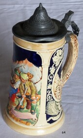 Flagstaff Hill Maritime Museum and Village
Ceramic - Beer Stein, Reinhold Merkelbach, 1945 to 1964
This mug was made by Reinhold Merkelbach. Reinhold Merkelbach was founded in 1845 by Wilhelm Merkelbach, a descendent of a long line of German potters, and the company eventually took the name of his son Wilhelm Reinhold Merkelbach, who left school early to get involved with the family business. The company became a major name in German ceramics, especially in the Jugendstil style. The company produced a large number of collectable beer steins in the late 18th and early 19th centuries, including a number of so-called “character steins.” In 1882, the firm began producing art pottery, which at that time was enjoying a revival and new appreciation in Europe in general and in Germany in particular. Reinhold Merkelbach produced ceramic objects both with and without pewter hardware but rarely altered its manufacturing techniques. Many of its products were destined for use at pubs, bars, or breweries as well as in the homes of Germany’s beer-drinking populace. It had a retail location in Munich and also sold products through its factory warehouse. In 1971, half of the company’s ownership was sold to W. Goebel KG and the firm’s name changed officially to Merkelbach Manufaktur GmbH & Co. KG. Goebel ultimately purchased the other half of the business before members of the Merkelbach family, along with a handful of collectors and former staff members, repurchased the factory in 1988. In 2007, Judith Merkelbach Engelmann decided to close the firm; demand for ceramics had been decreasing and the next generation of the family had no interest in maintaining the business. Luckily, Reinhold Merkelbach transferred its moulds to Töpferei Girmscheid Höhr-Grenzhausen to ensure that its best-known pieces of Jugendstil art pottery and steins would continue to be available to interested consumers and collectors.This beer stein was made around the mid-20th century by a popular German maker. It fits in with the context of maritime village life. At this current time, there is no particular connection with people, places and events. The German beer stein is made from ceramic ironstone. It has a bell-shaped hinged pewter lid with a leaf-shaped thumb lever. The lid has a pattern stamped on it. The design on the mug includes a woman in bright colours, a man holding a musket, and buildings in mountain settings. There are inscriptions on the mug. Marked "Made in Germany" "RM" "4070" (underside of mug) "05" to the side of mug flagstaff hill, warrnambool, shipwrecked coast, flagstaff hill maritime museum, maritime museum, shipwreck coast, flagstaff hill maritime village, great ocean road, beer stein, ceramic beer stein, reinhold merkelbach, drinking vessel