Showing 3153 items matching "miles"
-
 Bendigo Military Museum
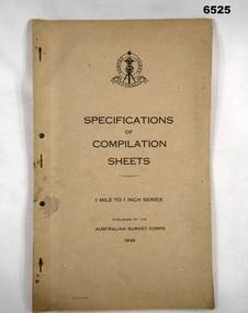
Document - Australian Survey Corps - Specifications of Compilation Sheets 1 Mile to 1 Inch Series 1948, Army Survey Corps, 1948
This document is the Australian Survey Corps - Specifications of Compilation Sheets 1 Mile to 1 Inch Series published in 1948. This map series was widely produced by the Australian Survey Corps across Australia.A foolscap sized 7 x page buff coloured card covered document, stapled and two holed punched. Cover has Australian Survey Corps badge and text.royal australian survey corps, rasvy, fortuna, army survey regiment, army svy regt, asr -
 Montmorency–Eltham RSL Sub Branch
Souvenir - Commemorative Medallion, Quartermasters sales and service inc
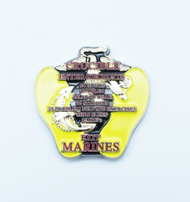
An irregular cloissonne medallion Yellow with gold illustrations and red and gold writing on one side and silver gun, bayonet and fist on a black background with red and silver writing Crucible Enter recruits 54 hours 48 miles 49 lbs of gear 36 stations 29 problem solving exercises 8 hrs sleep 3 MRE’s Exit Marines One mind any weapon the military mint, military medal -
 Ringwood and District Historical Society
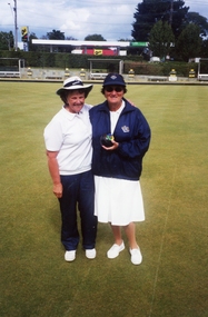
Photograph, Ringwood Bowls Club- Ladies Pairs winners, 2001/2002
Colour photograph."Note attached to photograph" Ringwood Bowls Club- Ladies Section. 2001/2002 Ladies Pairs Winners: Margaret Round- Skip. Eileen Aanensen- Lead. Runner- up: Gordana Baric- Skip. Anne Miles- Lead. -
 Ringwood and District Historical Society
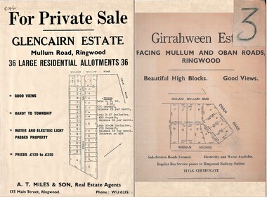
Document - Folder, Land Sale Advertisement, Glencairn Estate and Girrahween Estate, Ringwood - circa 1950s
Single sided advertisement for private sale of residential allotments - undated, circa 1950s.Subdivisions include Mullum Mullum Road,Glen Cairn Avenue (Glencairn), Oban Road, and Norman Avenue (later Hugh Street). Agent - A.T. Miles & Son, 175 Main Street, Ringwood, Phone WU 6215. -
 Orbost & District Historical Society
black and white photograph, C 1890s
The first hotel built in Orbost was the Club in 1885 an old wooden place on the corner built for J. A. Petersen of the Mitchell Hotel Bairnsdale, with the licence in the name of Mr Thomas Maguire (stepson of Petersen). William Archer was the proprietor at the time of the photograph. The coach driver was Sam Dyer and the coach is leaving for the goldfields at Combienbar. In June 1889 there was a rush to Mackenzie River, about 28 miles from Orbost, on Twelve Mile Creek. An estimated 80 men rushed the ground, but yields were patchy and large numbers eventually left. They were coming and going almost daily.The Club Hotel was the first hotel built in Orbost and remains a significant building in the town. It was an important hub for the township with many whole town meetings held there.A faded black / white photograph (with two copies) with a horse-drawn carriage loaded with men and the Orbost Club Hotel behind them. The photo is on a grey buff card.on back - " H. Adams. Driven by Sam Dyer - Leaving for the Combienbar Goldfields"orbost-club-hotel combienbar-goldfields -
 Tatura Irrigation & Wartime Camps Museum
Blackout shield
Used during WW2 to restrict the light from vehicle headlights and so make more difficult any observation by enemy air craft. The brightly lit camps, however where clearly visible for miles.Circular metal disc painted black. A small slit over which is a verandah. A white opaque circle in centre top.black out shields -
 Bendigo Military Museum
Map - EASTER NEW GUINEA NAVIGATION CHART, RAAF, Aug 1943
From the collection of "Maxwell Lennox Matheson" No.418447 RAAF. Enlisted 22/5/1942 Aged 19. Discharged 19/2/1948 - Rank FLTLT.This map is in colour. It is made of a stiff paper and has a map printed on both sides. Side1 - scale 1:2,315,000. 31.72 Nautical miles = 1 inch. It shows Eastern half of New Guinea. It also shows New Britain and New Ireland. Manus Island is at the top. Side 2 - Scale 1:1,000,000 - this shows Manus Island on right side, top of New Guinea at bottom edge (Wewak) and some other little islands. The map on side 1 has numerous navigation tracks and calculations in pencil. i.e. LAE, KOKODA, PORT MORESBY.ww2, raaf, new guinea -
 Bendigo Historical Society Inc.
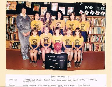
Photograph - GOLDEN SQUARE LAUREL STREET P.S. COLLECTION: PHOTOGRAPH GRADE 5 NETBALL B2
Coloured photo of the Grade 5 Netball - B2 Team of 1981. Photo taken in the library. The girls are wearing yellow t-shirts with a printed emblem and Golden Square printed on them and dark blue skirts. The Coach, Jeanette Bish, is wearing a grey tracksuit. The names of the girls are: Tracey Tesch, Julie Mannallack, Karen Dignan, Lisa Hocking, Brenda Miles, Julie Thompson, Kerry Lukeis, Joanne Tipple, Haylee Kurzke and Carla Jeffrey.education, primary, golden square laurel st p.s., golden square laurel street p.s. collection - photograph grade 5 netball b2, jeanette bish, tracey tesch, julie mannallack, karen dogman, lisa hocking, brenda miles, julie thompson, kerry lukeis, joanne tipple, haylee kurzke, carla jeffrey -
Yarrawonga and Mulwala Pioneer Museum
Plough, 1880's - 1890's
This plough was used by William Christians and John Holmes when they worked on the formation of Belmore Street, Yarrawonga The Single Furrow Plough - Hugh Lennon began making ploughs in Carlton from 1860's. Within 10 years the patented steel plough, suitable to Australian conditions, was outselling all imported cast iron, mouldboard ploughs. Early settlers (1870's) used this type of plough pulled by one horse to prepare ground for wheat sowing. Being a wheeled machine it allowed the ploughman to sit on the plough and saves miles of walking. -
 Bendigo Historical Society Inc.
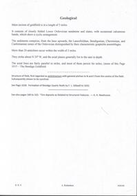
Document - MINING REPORTS - GEOLOGICAL REPORT OF MAIN SECTION OF GOLDFIELD
Handwritten notes by Albert Richardson, with typed copy, on a Geological report of main section in a length of 5 miles. Report mentions sandstones and slates, with occasional calcareous bands, which show a cyclic arrangement. Also mentioned are different zones of sediments, anticlines, structure of the field and references: Page 1028 Formation of Bendigo Quartz Reefs by F R Stilwell to 1032 and pages 160 to 163 'Ore deposits as Related to Structural Features - A H Newhouse. document, gold, mining reports, mining reports, geological report of main section of goldfield, the bendigo goldfields page 1015, formation of bendigo quartz reefs by f r stilwell page 1028 to 1032, ore deposits as related to structural features pages 160 to 163 a h newhouse -
 Robin Boyd Foundation
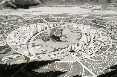
Slide, Robin Boyd
Colour slide in a mount. Magazine image of 'Horizon City' plan for El Paso (1959), Texas, USA. (Architect: Lucio Costa.)Made in Australia / Encircled 49 (Handwritten) / 1.5m (Handwritten) / city 'Horizon city' (Handwritten) / 167 mile (Handwritten) / lake park (Handwritten) / Texas new El Paso (Handwritten) / Brazchari (?): Lucio Costa (Handwritten) / 13 (Handwritten)the puzzle of architecture, slide -
 Stawell Historical Society Inc
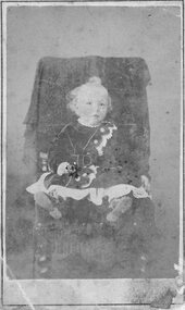
Photograph, Master Alfred Thomas Huttley -- Studio Portrait
B/W: toddler on a chair wearing dress, dark white lace buckled. colour tinted, fair curly hair holding a coured Rosealfred Thomas Huttley ( my Father) Stewart & Co 217 Bourke St. E Near Parliment House Melbourne A Large Framed copy Of This Portrit may be had Price is View taken within 20 Miles of Town. -
 Ringwood and District Historical Society
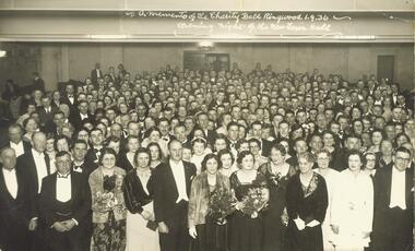
Photograph, A memento of the Charity Ball Ringwood 1.9.1936. Opening night of the New Town Hall
Black and white photograph (2 copies- 1 postcard size, 1 larger copy)Written on back of large photograph: "Opening night of Ringwood Town Hall- Charity Ball, 1936." Cr A.T. Miles front LH side next to Cr A. Blood. H.F. Pearson & Mrs Pearson also in frot Row. -
 Orbost & District Historical Society
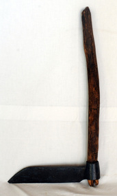
Paling knife, shingle froe, c. 1870s - 1930s
Likely used by the Jensen family who were early settlers in the Martin's Creek area, 35 miles north of Orbost, along the Bonang - Orbost Road in c. 1890. Peter Jensen came from Denmark. A flat iron blade, sharpened on the bottom and attached to a wooden handle. The blade has a pointed end.BRADES CO.shingle-making roofing-shingles house-construction -
 Ballarat Tramway Museum
Document, "Geelong Tramways Particulars - Opening and Length of Routes"
List of Geelong tramway routes and their opening dates and description - gives present length, where and extensions or variations. At the base of the sheet gives route miles, single track, double track and totals. Two copies held.Demonstrates a list of Geelong tram routes and their lengths.Document - A4 photocopied sheet.tramways, secv, geelong, tram tracks, statistics, history -
 Chelsea & District Historical Society Inc
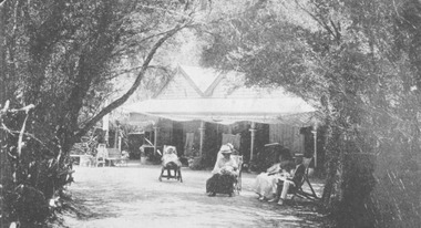
Photograph - Chalet at Aspendale, 1910
The Aspendale Chalet was about 18 miles from Melbourne between the railway station and the beach. It was a seaside "resort" where people could camp amongst the ti-trees. In 1911, the Chalet was subdivided and the blocks were sold.Four guest sitting on deck chairs in the Chalet gardens.chalet, aspendale, holidays -
 Melbourne Legacy
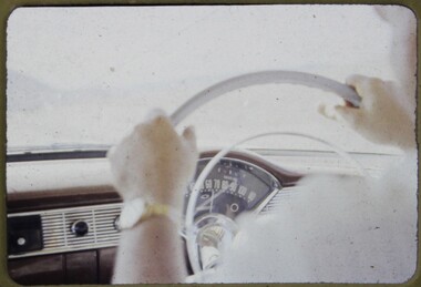
Slide, Operation Firewood, 1960s
Two colour slides of a steering wheel, dashboard and speedometer. One shows 65 miles per hour and the second 70 miles per hour. It was during Operation Firewood. Legatees would organise collection of wood from the country and distribute it to widows in metropolitan Melbourne. Other slides show the cutting and loading of wood and delivery to widows in metropolitan Melbourne. Was with many other slides taken in the 1950s and 1960s. The slides have been photographed to make digital images and moved to archive quality sleeves. In many cases the original images were not well focussed and the digital image the best available.A record of Legacy helping widows by sourcing, supplying and delivering firewood. When open fires were the main source of heating, a load of firewood and help moving it, would have been very important to the widows.Colour slide x 2 of the steering wheel and speedometer during Operation Firewood in brown Anscochrome cardboard mount.Printed on front in red ink 'Anscochrome / View from this side / Made in Australia'. Hand written on front of one '65MPH Warming up' and on the other '70MPH just cruising' in blue pen. Printed on reverse in red ink 'Processed by Verycolor photo labs. Melbourne, Victoria'.operation firewood, cars -
 Ringwood and District Historical Society
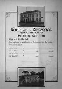
Certificate, Borough of Ringwood- Municipal Baths. Swimming Certificate c1950's
Swimming Certificate for the Borough of Ringwood Municipal Baths. Proficient in swimming in 66 yards, 200 yards, and 400 yards and 1 mile and Life Saving Tests. Two good B&W pictures of Town Hall and pool.Sample swimming certificate, cardboard, with two B&W pictures on it. At the top is a picture of the old Ringwood Town Hall, and at the bottom a picture of the Ringwood outdoor swimming pool and building. -
Moorabbin Air Museum
Document (Item) - 3 View Drawings For Davis Da-2
Description: A set of drawings of the Bristol Boxkite as drawn by FW Miles (note these modern drawings, not original manufacturers drawings) The Boxkite (officially the Bristol Biplane) was the first aircraft produced by the British and Colonial Aeroplane Company Level of Importance: . -
 Clunes Museum
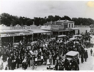
Photograph, c1920
Image shows looking east along Fraser Street, showing shops, including L. Cook Tearooms, M. Downes Boot Warehouse, Cash Draper, 4 Miles Central Garage, F C Henry, Barnetts.1 Black and white photograph of Fraser Street Clunes after a parade c1920, street is filled with people celebrating .2 Larger reproduction of the above photograph in black and white.1 £4.00parade, fraser street, 1920, l cook tearooms, m downes boot warehouse, cash drapery, h miles central garage, f c henry, barnetts -
 Geelong Cycling Club
Trophy, 2009
The Annual 20 Road race has been the classic championship of the Geelong Cycling Club from 1914 onwards. It was called the Annual 20 because it was originally a 20 mile race. 2009 marked the 97th running of the race. This award highlights the significance of this Road Race to the Club.Gold coloured trophy on a burgundy base. A cyclist is depicted on the top of a column with the word 1st adhered to the front of the column."Geelong Cycling Club - 2009/Annual 20/Road Race/1st Place"geelong cycling club; annual 20; road race; 1st place; -
 Peterborough History Group
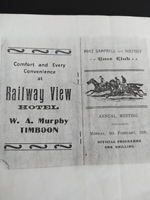
Booklet - Race Card, Port Campbell and District Race Club Annual Meeting Monday 8th February 1926
Race programme for horse racing event at the Port Campbell race track, located near Two Mile Bay, where the rifle range is now located. Lists horses and owners. Includes advertising for local businesses at the time.Significant as it indicates sporting and social activities in 1926. Photocopy of original race programme at the Port Campbell Racetrack.port campbell horse racing, port campbell race track, railway view hotel timboon, port campbell hotel, cobden hotel, 1926 -
 Trentham and District Historical Society
Book - Log book, Observers Log - Volunteer Air Observers Corps
Used during WW2. Trentham Air Observers Corps logbook of plane traffic spotted from Cranney's Hill lookout. The lookout was located one mile east of Trentham township. The Observers were volunteers, mainly women.Foolscap sized book with brown paper cover. Hand-written entries.trentham, volunteer air observers corps, spotters, cranney's hill, shirley trewella, gamble, world war 2, home front, log-book -
Ringwood and District Historical Society
Book, Proposition Book for Independent Order of Rechabites, Hope of Ringwood Tent No. 372 - 23-Apr-1900 to 3-May-1927, 23-Apr-1900 to 3-May-1927
Used in Ringwood by the Victorian District Independent Order of Rechabites No. 82|Proposition Book - Hope of Ringwood Tent No. 372|Gives names, occupations, residence, age, marital status, wife's name, age, proposer, seconder and date. The book contains many prominent local names of the early 1900s.Black covered book - cardboard covered with cloth. Red leather corners and spine. Some blank pages in centre of book.; Used in Ringwood by the Victorian District Independent Order of Rechabites No. 82; Proposition Book - Hope of Ringwood Tent No. 372; Gives names, occupations, residence, age, marital status, wife's name, age, proposer, seconder and date. The book contains many prominent local names of the early 1900s. +Additional Keywords: Miles / Pollard / ParkerVictorian District Independent Order of Rechabites No. 82; Proposition Book - Hope of Ringwood Tent No. 372 -
 Kiewa Valley Historical Society
Set of 6 framed photographs - Kiewa Hydro Electric Scheme
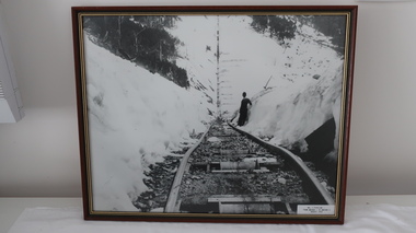
Official photo of KHES constructed by SECVOfficial photo of KHES in the Kiewa Valley1. No. 1 Pipeline - from Anchor 1 to Anchor 5. August 1955 2. Junction Dam - General View from Downstream - May 1943 3. No. 3 Power Station - Clover Flat Camp - February 1951 4. Clover Dam - October 1954 5. View from Downstream of Junction Dam - July 1943 6. Upper Kiewa Valley Road 3 to 4 Mile - Mt Arthur in Background - July 1954 khes, secv -
 Bendigo Historical Society Inc.
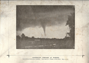
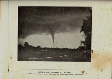
Photograph - TORNADO AT MARONG, 27 Sept 1911
Copy of black and white photograph of tornado at Marong. Dark sky above with funnel to ground. Printed on cream card with printed border. Inscriptions: on front - below image 'Australian Tornado at Marong, loss of life and destruction of property. Photo taken by C Hosken, three miles distant. Sept. 27, 1911. On TR corner 'MP106'. On back - circular stamp 'Royal Historical Society of Victoria, Bendigo Branch', '2nd of 2 copies' hand written in ink.topic, natural disaster -
 Bendigo Historical Society Inc.
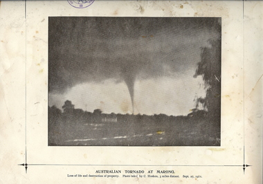
Photograph - TORNADO AT MARONG, 27 Sept 1911
Copy of black and white photograph of tornado at Marong. Dark sky above with funnel to ground. Printed on cream card with printed border. Inscriptions: on front - below image 'Australian Tornado at Marong, loss of life and destruction of property. Photo taken by C Hosken, three miles distant. Sept. 27, 1911. On TR corner 'MP106'. On back - circular stamp 'Royal Historical Society of Victoria, Bendigo Branch', '2nd of 2 copies' hand written in ink.topic, natural disaster -
 Ballarat Tramway Museum
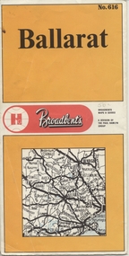
Map, Broadbent's, "Broadbent's Map 616 Ballarat", c1960
Yields information about the extent of Ballarat in the early to mid 1960's shows the tram lines and other rail lines in the district.Printed street map titled "Broadbent's Map 1616 Ballarat" printed in colour on one side only of a folded (10) sheet. Shows the suburbs of Ballarat, tram lines, has a scale in miles, Ballarat District map and an index to streets. Also points interest and historical interest. also shows railways lines. Map used as the base for the tram line map in the display area in the depot. Large Res scan made 28/1/2011."50c" in pencil on front cover.trams, tramways, map, ballarat, broadbent's, railways -
 Melbourne Tram Museum
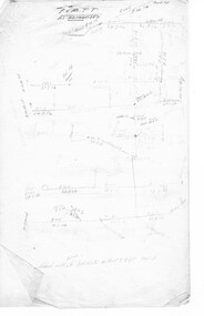
Document - Research Notes, H. S. McComb, development and timing of the "PMTT" - part 1, 1950's
Set of papers, handwritten concerning the development and timing of the "PMTT", Prahran and Malvern - about 13 sheets. Prepared by H. S. McComb - gives layout of the PMTT system, sketches of track layout, opening dates, sketches of various junctions, bridges, track miles, junctions, reconciliations of track lengths from various sources, Camberwell Junction and cross overs. Items 2041 to 2052 within box 72.3 in a brown folder marked "PMTT" in red pencil.trams, tramways, pmtt, malvern, routes, track, malvern depot, camberwell junction, surveys