Showing 2630 items
matching otway-reef
-
 Bendigo Historical Society Inc.
Map - BENDIGO GOLD FIELD LONGITUDINAL VERTICAL PROJECTIONS
Bendigo gold field map showing vertical projections of portions of three anticlinal axial planes showing stratigraphical zones and caps of known saddle reefs. This map forms part of the Geological Survey of Victoria, Structure of Bendigo Goldfield report, No. 47, 1923. H.Herman, late Director of Geological Survey.Geological Survey Victoriabendigo, gold mining, vertical projections, bendigo, goldfield, gold mining, reef lines, mining companies, geological survey -
Bendigo Historical Society Inc.
Map - UNITED HUSTLER'S & REDAN MINE - TRANSVERSE SECTIONS N & S OF SHAFT UNITED HUSTLER'S & REDAN MINE
Transverse Sections N & S of Shaft United Hustler's & Redan Mine on the Hustler's Line of Reef Bulletin No 33, Plate No XXX. Map shows some of the stone encountered on the levels and depth. Geological Survey of Victoria emblem and signed by H A Whitdan, Underground Survey Office Bendigo, September 1913.mining, parish map, united hustler's & redan mine, transverse sections n & s of shaft united hustler's & redan mine, hustler's line of reef -
Bendigo Historical Society Inc.
Document - THE UNITED DEVONSHIRE MINE - NOTES ON THE UNITED DEVONSHIRE MINE
One handwritten and three typed copies of notes on The United Devonshire Mine on the New Chum Line of Reef. Notes include size of lease, depth of shaft, East Shaft, locality, a warning on the area where the shaft is, plant, early history. Leading and Prominent, Best Gold, Total Yields and Dividends.document, gold, the united devonshire mine, the united devonshire mine, notes on the united devonshire mine, california hill state school, freeman & coy, the 'danes', princess alexandra, the premier coy, saxon & celt, south devonshire, new st mungo, duke of edinburgh, phoenix mine, duchess tribute, duchess of edinburgh, albert battery, mines dept special edition australian mining standard 1/6/1899, mines dept booklet bendigo goldfields 1936, mines dept annual and quarterly reports, annals of bendigo mining sections 1881 - 1916, a richardson, mines dept bulletin no 47 structure of bendigo goldfield h herman 1923, the bendigo goldfield registry j n macartney 1/3/1871 -
Bendigo Historical Society Inc.
Document - THE LAZARUS MINE - PRODUCTION NOTES OF THE THE LAZARUS MINES
Handwritten notes including depth of shaft, years, call, dividends, tons of ore, amount of gold, authority and remarks. On the second page:- Lazarus, Lazarus New Chum and Lazarus No 1. 1886 At 1675 ft Gold discovered unexpectedly when timbering. Manager cut in on reef, found good stone.document, gold, the lazarus mine, the lazarus mine, production notes of the the lazarus mines, early workings, begelhole & co (north), geo gibbs & lazarus claim, watson & co, ballerstadt & co, lazarus freehold, lazarus freehold, lazarus new chum (april), lazarus co, lazarus no 1, lazarus no 2, lazarus new chum m co, abe lincoln trib co, central new chum, abe lincoln sands, bendigo goldfield history and production page 107, annals 1886 page 208 -
Bendigo Historical Society Inc.
Document - THE LAZARUS MINE - NOTES ON THE THE LAZARUS MINE
One handwritten and three typed copies of notes on the The Lazarus Mine including the Lazarus New Chum and the Lazarus No 1 on the New Chum Line of Reef. Notes include locality, depth of shafts, size of lease, plant, early history, the Lazarus Company, Prominence, Best Gold and Total Gold Yields.document, gold, the lazarus mine, the lazarus mine, notes on the the lazarus mine, lazarus new chum, lazarus no 1, australian headquarters survey unit, george lansell, new chum hill, b c v 8 studios, sheepshead, central red white & blue, mr lazarus, lansell's 222, old chum mine, lazarus company, mr george gibbs, lansell's fortuna, ballerstedt, mr barnet lazarus, the black lead, the white lead, mount alvernia hospital, mines dept special edition 'australian mining standard' 1/6/1899, mines dept booklet 'bendigo goldfield' 1936, mines dept annual and quarterly reports, annals of bendigo mining sections 1868 - 1910, a richardson, the bendigo goldfield registry j n macartney 1/3/1871 -
Stawell Historical Society Inc
Geological specimen - Mining, Broken Dimond Drill Pieces
Used to drill through the red Iron stone - reefs end of Stawell. Found along Darlington Road after drilling to erect a Power Pole 2X Cylindrical Broken used Dimond Drill - Core Samples, Basalt - granite -
 Torquay and District Historical Society
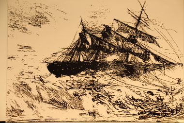
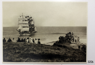
Photograph (copy)
Photograph appears to have been copied from an unknown newspaper but is believed to show the Joseph H Scammell on the reef at Point Danger Torquay in 1891.Black and White photocopyshipwrecks great ocean road victoria -
 Stawell Historical Society Inc
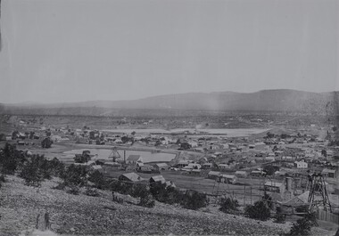
Photograph, View of Stawell from Big Hill 1874 showing mines looking towards South end of Black range -- 4 Photos
Visible Nelsons Criterion Hotel, Wimmera Crushing Mill, Odd Fellows Arms hotel, F.H. Oliver & Co Grain Merchant, Reefs Restaurant.Holtermann Black and White photograph of Stawell from Big Hill with mining in foreground. April 1874. Wimmera Crushing Mill and settling pond at centre of photograph. Stawell water supply centre left of photo. Black Range in Background.mining, panorama -
 Wannon Water
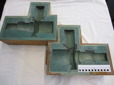
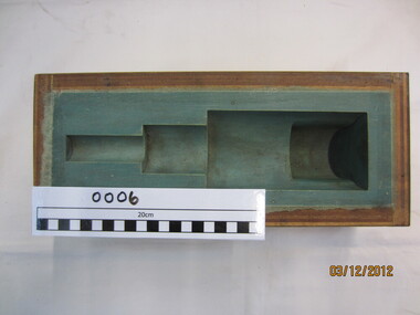
High pressure scour valve mould (casting) watermains, Mould
Used to make casting moulds for the high pressure main Otway Supply System pipeline. Was used in conjunction with scour valve mould, Wf mould and valve stem mould in the 1980sUsed to manufacture spare parts for the main Otway pipeline2 wooden boxes each contain the mould for casting valves for wtaermains pipelines. Moulds lined with green coloured sealantwatermains written in black ink on outside of boxotway region, water supply, pipelines, valves -
 Parks Victoria - Gabo Island Lightstation
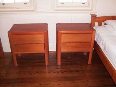
Bedside tables
Used at Lightstation. There are an identical pair in the studio cottage at Cape Otway Lightstation so they are most likely purchased for the Lightstation. The two drawer table has the name ‘Kalmar Melbourne’ on the rear confirming its provenance.The three tables, along with the nest of tables, chest of drawers , and two bookcases would have been purchased as part of a large order placed by the Commonwealth Government sometime between 1957 and the early 1970s, when Kalmar was concentrating on large commissions. Cape Otway Lightstation has a pair of the same bedside tables. Gabo Island’s two bedside tables have first level contributory significance as part of a set, and for their clear provenance to Steven Kalmar whose functional designs introduced modern, low cost furnishings to a number of Australia’s lightstations.Two Scandinavian style bed-side tables. Two drawers in each. Chipboard veneer top. Solid wood frame / legs. Stained an orange colour. -
Bendigo Historical Society Inc.
Document - MERLE HALL COLLECTION: ROSALIND PARK CREATIVE VILLAGE BENDIGO PLAN OF MOSAIC AND TYPICAL REEF CONTOURS, 1990s
MERLE HALL COLLECTION: ROSALIND PARK CREATIVE VILLAGE BENDIGO Plan of Mosaic and Typical Reef Contours 3858.14.pdf contains five pages First Page: Describes the plan the mosaic is a stylised representation of the cenral area of the main Bendigo Goldfield. A typical croos section ogf the Bendigo Goldfield. The mosaic are based on actual mine layouts. The artist has used gold as her inspiration. Second Page: A plan of the mosaic using the atomic structure of gold. Third Page: A plan of the quartz vains winding through the earth, containing gold in its various forms. Fourth Page: A typical reef layout in the Bendigo Goldfields and cross sections. Fifth page: On of the Mosiaic depicking a bird -
 Flagstaff Hill Maritime Museum and Village
Photograph, Original image recorded between 14 Nov 1908 and early Jan 1909
The photograph represents the original complete landscape (southerly) view of the FALLS OF HALLADALE shipwreck which occurred at 3 am on the 14th of November 1908. This image includes three groups of well-dressed Edwardian sightseers on the clifftop and a rocky headland. Subsequent reproductions of this well-known image have been cropped to a striking portrait view, emphasising the vertical line of the masts and sails of the sailing ship, and excluding the groups of sightseers on the adjoining headland. The small girl in the foreground and the loose topsail on the foremast are common to both the landscape and the cropped portrait images of this memorable scene. The photograph was taken at an early stage of the ship’s final days, somewhere between the date of her grounding in mid-November 1908 and early January 1909, when salvagers began dynamiting her masts to get to the cargo in her holds. The heavily laden FALLS OF HALLADALE was 102 days out of New York when the swell of the Southern Ocean lifted her onto the rocks near Peterborough. At the time she was sailing at six knots in a light breeze, her sails fully set and on an ENE tack. Mist over the land created an optical illusion of a distant horizon and the crew believed they were at least ten miles off the coast. When high cliffs loomed up out of the darkness it was too late in the light conditions to change tack or let go the anchors. Within minutes of running aground, her decks were awash and the holds filling with water. Captain Thomson and his 29 crew took to the boats, leaving the vessel stranded on the reef, looking awkwardly graceful in her predicament. Firmly wedged between two parts of the reef and with all her square-rigged sails still set, FALLS OF HALLADALE provided a landmark visible for miles. Over the following two months she attracted hundreds of sightseers, including contemporary photographers. A Court of Marine Inquiry at Melbourne on 30 November 1908 found Captain Thomson guilty of a gross act of misconduct ― in that he carelessly navigated the ship, neglecting to take proper soundings and failing to place the ship on the port tack before it was too late to do so. His Master’s Certificate of Competency was suspended for six months and he was ordered to pay £15/15/- toward the costs of the inquiry. It was an expensive outcome for the captain but his error provided many weeks of inexpensive entertainment for coastal residents and visitors to Peterborough. To judge from the standard of formal dress in this photograph, visiting the wreck was considered a special occasion as well as a popular one. Falls of Halladale The iron-hulled, four-masted barque, the Falls of Halladale, was a bulk carrier of general cargo. She left New York in August 1908 on her way to Melbourne and Sydney. In her hold, along with 56,763 tiles of unusual beautiful green American slates (roofing tiles), 5,673 coils of barbed wire, 600 stoves, 500 sewing machines, 6500 gallons of oil, 14400 gallons of benzene, and many other manufactured items, were 117 cases of crockery and glassware. Three months later and close to her destination, a navigational error caused the Falls of Halladale to be wrecked on a reef off the Peterborough headland at 3 am on the morning of the 15th of November, 1908. The captain and 29 crew members all survived, but her valuable cargo was largely lost, despite two salvage attempts in 1908-09 and 1910. ABOUT THE ‘FALLS OF HALLADALE’ (1886 - 1908) Built: in1886 by Russell & Co., Greenock shipyards, River Clyde, Scotland, UK. The company was founded in 1870 (or 1873) as a partnership between Joseph Russell (1834-1917), Anderson Rodger and William Todd Lithgow. During the period 1882-92 Russell & Co. they standardised designs, which sped up their building process so much that they were able to build 271 ships over that time. In 1886 they introduced a 3000 ton class of sailing vessel with auxiliary engines and brace halyard winches. In 1890 they broke the world output record. Owner: Falls Line, Wright, Breakenridge & Co, 111 Union Street, Glasgow, Scotland. Configuration: Four masted sailing ship; iron-hulled barque; iron masts, wire rigging, fore & aft lifting bridges. Size: Length 83.87m x Breadth 12.6m x Depth 7.23m, Gross tonnage 2085 ton Wrecked: the night of 14th November 1908, Curdies Inlet, Peterborough south west Victoria Crew: 29 The Falls of Halladale was a four-masted sailing ship built-in 1886 in Glasgow, Scotland, for the long-distance cargo trade and was mostly used for Pacific grain trade. She was owned by Wright, Breakenridge & Co of Glasgow and was one of several Falls Line ships, all of which were named after waterfalls in Scotland. The lines flag was of red, blue and white vertical stripes. The Falls of Halladale had a sturdy construction built to carry maximum cargo and able to maintain full sail in heavy gales, one of the last of the ‘windjammers’ that sailed the Trade Route. She and her sister ship, the Falls of Garry, were the first ships in the world to include fore and aft lifting bridges. Previous to this, heavily loaded vessels could have heavy seas break along the full length of the deck, causing serious injury or even death to those on deck. The new, raised catwalk-type decking allowed the crew to move above the deck stormy conditions. This idea is still used today on the most modern tankers and cargo vessels and has proved to be an important step forward in the safety of men at sea. On 4th August 1908, with new sails, 29 crew, and 2800 tons of cargo, the Falls of Halladale left New York, bound for Melbourne and Sydney via the Cape of Good Hope. The cargo on board was valued at £35,000 and included 56,763 tiles of American slate roofing tiles (roof slates), 5,673 coils of barbed wire, 600 stoves, 500 sewing machines, 6,500 gallons of oil, 14,400 gallons of benzene, plumbing iron, 117 cases of crockery and glassware and many other manufactured items. The Falls of Halladale had been at sail for 102 days when, at 3 am on the night of 14th November 1908, under full sail in calm seas with a six knots breeze behind and misleading fog along the coast, the great vessel rose up on an ocean swell and settled on top of a submerged reef near Peterborough on south-west Victoria’s coast. The ship was jammed on the rocks and began filling with water. The crew launched the two lifeboats and all 29 crew landed safely on the beach over 4 miles away at the Bay of Islands. The postmistress at Peterborough, who kept a watch for vessels in distress, saw the stranding and sent out an alert to the local people. A rescue party went to the aid of the sailors and the Port Campbell rocket crew was dispatched, but the crew had all managed to reach shore safely by the time help arrived. The ship stayed in full sail on the rocky shelf for nearly two months, attracting hundreds of sightseers who watched her slowly disintegrate until the pounding seas and dynamiting by salvagers finally broke her back, and her remains disappeared back into deeper water. The valuable cargo was largely lost, despite two salvage attempts in 1908-09 and 1910. Further salvage operations were made from 1974-1986, during which time 22,000 slate tiles were recovered with the help of 14 oil drums to float them, plus personal artefacts, ship fittings, reams of paper and other items. The Court of Marine Inquiry in Melbourne ruled that the foundering of the ship was entirely due to Captain David Wood Thomson’s navigational error, not too technical failure of the Clyde-built ship. The shipwreck is a popular site for divers, about 300m offshore and in 3 – 15m of water. Some of the original cargo can be seen at the site, including pieces of roof slate and coils of barbed wire The shipwreck of the FALLS OF HALLADALE is of state significance: Victorian Heritage Register No. S255. The Falls of Halladale shipwreck is listed on the Victorian Heritage Register (No. S255). She was one of the last ships to sail the Trade Routes. She is one of the first vessels to have fore and aft lifting bridges. She is an example of the remains of an International Cargo Ship and also represents aspects of Victoria’s shipping industry. The wreck is protected as a Historic Shipwreck under the Commonwealth Historic Shipwrecks Act (1976).Black and white photograph on cream-coloured backing card and in good condition. Description of Image: Quadrant 01, vessel with full set of sails perched on reef with stern submerged; Quadrant 02, predominantly clear sky over flat calm sea; Quadrant 03, two groups of standing sightseers on rocky promontory with three individuals approaching from far left foreground; Quadrant 04, fifteen well dressed sightseers seated on grassed cliff top including one child and six women. There is a deliberately obscured inscription in white ink along lower border or foreground of photograph.Letters in upper case and white contrast stretching across the grassed foreground of photograph have been smudged over by development process and are largely indecipherable. However rear of backing board of identical but reduced image Reg. No. 3207 bears pencilled words “Mrs Francis” and “Wreck of ‘Falls of Halladale’ Peterborough 1908”, which accords with what remains of the initial inscription.flagstaff hill, warrnambool, shipwrecked-coast, flagstaff-hill-maritime-museum, maritime-museum, shipwreck-coast, flagstaff-hill-maritime-village, falls of halladale, shipwreck spectacle, shipwreck photograph, peterborough reef, edwardian sightseers, russell & co. -
 Federation University Historical Collection
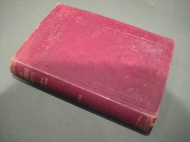
Book, The Cyanide Process of Gold Extraction, 1906
Maroon hard covered book of 239 pages. Along with technical information the book looks at cyanide processing around the world including South Africa, New Zealand, Kalgoorlie, Golden Horseshoe Mine, Great Boulder Main Reef, New South Wales, United States of America, Mexico, India, Canada.cyanide, mining, mcarthur-forrest process, laboratory, slimes, leaching, zinc precipitation, siemens-halske process, cyanide plantbutters' distributer, cyanide poisoning antidotes, south africa, new zealand, waihi mine, waikino, south kalgoorlie, united states, mexico, india -
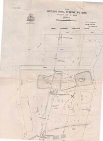
 Bendigo Historical Society Inc.
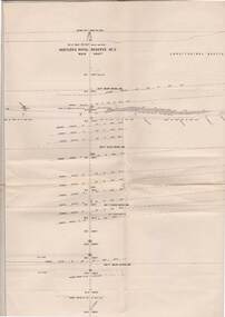
Map - STRUGNELL COLLECTION: HUSTLER'S LINE OF REEF, BENDIGO, September 1913
Map, Hustler's Line of Reef, Hustler's Royal Reserves No. 2 Co, Longitudinal Section.Plate No.V111 (8). Bulletin No 33 Signed H.A.Whitelaw Underground survey Office Bendigo September 1913 Drawing shows mine shaft to over 1746 feet deep and appears to show samples of connecting horizontal shaftsUnderground Survey Office, Bendigo.map, bendigo, hustler's royal reserve no. 2 mine* -
 Bendigo Historical Society Inc.
Map - STRUGNELL COLLECTION: HUSTLER'S LINE OF REEFS, BENDIGO, September 1913
Map, Hustler's Line of Reefs, Great Extended Hustler's Mine, Longitudinal Section Plate No X111 (13). Bulletin No 33 Signed H.A.Whitelaw Underground survey Office Bendigo September 1913 Drawing shows mine shaft to over 3454 feet deep and appears to show samples of connecting horizontal shaftsUnderground Survey Office, Bendigo.map, bendigo, great extended hustler's mine -
 Bendigo Historical Society Inc.
Map - STRUGNELL COLLECTION: HUSTLER'S LINE OF REEFS, BENDIGO, September 1913
Map, Hustler's Line of Reefs, Hustler's Royal Reserve No. 2 Mine, Bendigo.Plate No. V (5).. Great Extended Hustler's Lease, Imperial Hustler's, Hustler's Royal Reserve No. 2 Park & Main Shafts, Fortuna Hustler's Lease.Bulletin No 33 Signed H.A.Whitelaw Underground survey Office Bendigo September 1913Underground Survey Office, Bendigo.map, bendigo, hustler's royal reserve no. 2 mine* -
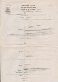 Bendigo Historical Society Inc.
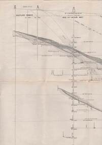
Map - STRUGNELL COLLECTION: HUSTLER'S LINE OF REEF, BENDIGO
Map, Hustler's Line of Reef, Bendigo, Fortuna Hustler's Mine, Longitudinal Section. Plate No. 1V (4). NOTE--- Plates 4,8,13,29,26 & 31 form a Longitudinal Section from Fortuna Hustler's to Hustler's Consols Mine.Bulletin No 33 Signed H.A.Whitelaw. Drawing shows the vertical shaft descending to over 2228 feetUnderground Survey Office, Bendigo.map, bendigo, fortuna hustler's mine -
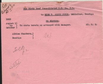 Bendigo Historical Society Inc.
Document - MISS G ALICE JONES COLLECTION: ACCOUNT
New Birds Reef Consolidated G. M. Co. N. L. to Miss G. Alice Jones. Pink paper dated August 1 to October 1923. re Sievers. To costs herein as arranged with Manager £3.3.0. "r338 Delivered by KD 4-12-23" written in the top left corner.miss g. alice jones - solicitor - account, new birds reef consolidated g. m. co n l, sievers -
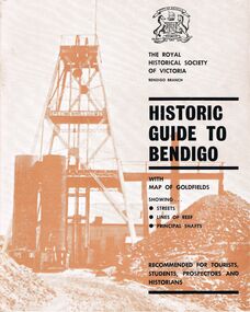 Bendigo Historical Society Inc.
Book - HISTORIC GUIDE TO BENDIGO
Five copies of ' The Royal Historical Society of Victoria Bendigo Branch Historic Guide to Bendigo with map of goldfields showing streets, lines of reef, principal shafts. Recommended for tourists, students, prospectors and historians.' Cambridge Press, Bendigo. Third Edition. Maps, photos, illustratons. Only four copies have maps.bendigo, history, gold mining, book, books, bendigo, bendigo history, history, victorian history, victoria, australian history, gold fields, gold, gold discoveries, the royal historical society of victoria -
 Bendigo Historical Society Inc.
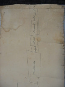
Document - PLAN SHOWING THE VARIOUS CLAIMS ON THE NEW CHUM VICTORIA , ST MUNGO & DEVONSHIRE REEFS BENDIGO
Map of mines - calico scroll showing locations of various claims .printed in black ink on off-white Calico with turned wooden ends on scroll -missing one wooden end , some stains and creasing / Plan showing the various Claims on the New Chum Victoria , St Mungo & Devonshire reefs BendigoW Holmes , printer & lithographer , Sandhurstorganization, mining, industrial, w holmes , printer & lithographer , sandhurst/new cum , victoria st mungo & devonshire reefs bendigo -
Bendigo Historical Society Inc.
Document - MINING REPORTS - BENDIGO GOLDFIELD PRODUCTION
Handwritten notes detailing tons of ore and ounces of gold it produced for mines on the Hustlers, Paddy's Gully, Garden Gully, Deborah, Sheepshead, New Chum, Nell Gwynne, Napoleon, Lancashire, Thistle and Christmas Lines of Reef. Also the Napoleon Syncline and Mary McDonald Spurs. Also mentioned is the average per ton.document, gold, mining reports, mining reports, bendigo goldfield production, m d, q r & a r, bendigo advertiser, b m l, burrell's records -
Bendigo Historical Society Inc.
Document - VIRGINIA MINE - VIRGINIA MINE STATISTICS
Handwritten notes on the Virginia Mine. Notes include gold yield, dividends, depth of shaft, wages bill for each fortnight, thickness of reef, length of claim, mine workings, machinery, winding engines, boiler pressure and battery. Mine Manager Mr Hooper and Battery Manager Mr S H Patterson.document, gold, virginia mine, virginia mine, virginia mine statistics, the bendigonian annual xmas 1908, gt northern mine, mr hooper, mr s h patterson -
Bendigo Historical Society Inc.
Document - VICTORIA QUARTZ - VICTORIA REEF QUARTZ MINE MANAGER'S REPORT
Two copies of the Victoria Reef Quartz Mine Managers report. The report mentions putting up the poppet heads, drainage assessment, water level and two men offered 50/- per week. Dates 14/6/1861, 22/6/1861, 18/10/1861 and 13/12/1861.document, gold, victoria quartz, victoria quartz, victoria reef quartz mine manager's report, victoria reef gold mines, gerraws, mr cook, mr sterry, mr mollison, endeavour coy, the victoria reef gold mines coy, ironbark co, endeavour, chenoweth, mr hoskins -
Bendigo Historical Society Inc.
Photograph - KEN BICE COLLECTION: CENTRAL NELL GWYNNE MINE, BENDIGO
Copy of photo: image shows line of miners standing on rock ledge underground, holding lamps, one sitting on ladder on RH side of image. On back Central Nell Gwynne Mine, Bendigo. Stopes on cap of Central Nell Gwynne Reef, 870 ft. level, 1938. This is a digital only photograph.bendigo, mining, central nell gwynne, bendigo, central nell gwynne, mining, miners, lamps -
Bendigo Historical Society Inc.
Document - NEW MOON MINE - NOTES ON THE NEW MOON MINE
Handwritten notes on the New Moon Mine on the Garden Gully Line of Reef. Notes include depth of Shaft, locality, Formation & Registration, Last year of production 1931, Size of lease, Early History, Plant, Poppet Legs, Telephone & Electric Signalling, Gold Obtained, Prominence, Total Gold Production and Dividends.document, gold, new moon mine, new moon mine, notes on the new moon mine, garden gully line of reef, prospector's vote, h harkness & coy, thompson & co of castlemaine, bendigo amalgamated goldfields coy, mines dept special edition australian mining standard 1/6/1899, mines dept booklet bendigo goldfield geo brown 1936, mines dept annual and quarterly reports, annals of bendigo mining sections 1907 to 1931, a richardson, souvenir declaration 200th dividend issued by directors new moon 1/12/1906, mines dept bulletin no 47 structure of bendigo goldfield h herman 1923 -
Bendigo Historical Society Inc.
Archive - MCCOLL, RANKIN AND STANISTREET COLLECTION: NELL GWYNNE REEF MINING BOX, 1930's - 1940's
Mining Box. Painted green with yellow interior. Nell Gwynne Reef painted on the front of the box. Tag number 488, now box number 9. Box contains Minute Book (from 3/10/1939 to 21/8/1947) and financial books for Forbes Carshalton GMC N/L.mining, parish map, nell gwynne reef, mccoll, rankin & stanistreet, nell gwynne reef, forbes carshalton gmc n/l, mining box -
 Wannon Water
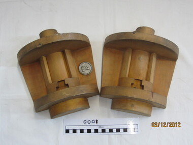
Valve stem mould
Used to make casting moulds for the Otway Water Supply System in the 1980s. Used in conjunction with scour valve mould, Wf mould and high pressure scour valve mould (casting) watermainsUsed in the manufacture of spare parts for the Otway Water Supply pipelinevalve stem casting mould in plywood boxwatermains in black textaotway region, water supply, pipelines -
 Wannon Water
Wf valve mould, Mould
Used in the manufacture of spare parts for the Otway Water supply pipeline in the 1980s. Used in conjunction with scour valve mould, valve stem mould and high pressure scour valve mould (casting) watermainsUsed to manufacture spare parts in the 1980sWooden casting mould in 2 piecesotway region, pipelines, water supply -
 Wannon Water
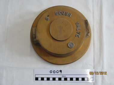
3" Scour valve mould, Valve mould
Used in the manufacture of spare parts for the Otway Water supply pipeline in the 1980s. Used in conjunction with scour valve mould, valve stem mould and high pressure scour valve mould (casting) watermains Used to manufacture spare parts in the 1980swooden casting mould3" Scour Valve in silver raised lettering WF Logo in silver and raise In black texta - DEMAC 4 off C.I.otway region, pipeline, water supply -
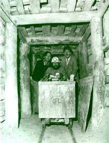 Federation University Historical Collection
Photograph - Black and White, 1988, Three men standing behind a trolley in a mine tunnel, 06/1988
This image was taken at the conclusion of a special eight week "Crash course" in mining, requested by Eastern Reefs. It was used in the Ballarat School of Mines Review, 1988, page 7.Black and white image of three men standing behind a trolley in a mine tunnel showing supporting beams (thought to be Sovereign Hill) They are from left to right Ernie Terrill (Ballarat CES), Raymond Collins (Ballarat School of Mines Mining Student) and Malcolm Vallance (Ballarat School of Mines Special Projects Manager).ballarat school of mines, mines, mining, mining trolley, mine truck, mining railway, malcolm vallance, mal vallance, raymond collins, ernie terrill, eastern reefs, sovereign hill, mining education