Showing 835 items
matching parish map
-
 Bendigo Historical Society Inc.
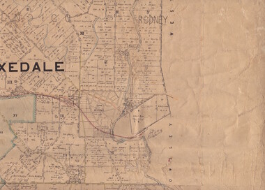
Map - Parish of Strathfieldsaye
... and Survey Melbourne by T E McGauran 24.3.07. Price 1/-. Map Parish ...Map owned by Henry Thomas (Jack) Qualtrough who worked for the Victorian Forestry Commission. Shire of Strathfieldsaye County of Bendigo canvas backed map. L5169. Includes Axedale, Kimbolton, Eppalock and Sedgewick. Photographed/Lithographed for the Department of Lands and Survey Melbourne by T E McGauran 24.3.07. Price 1/-.map, axedale, kimbolton, sedgewick, eppalock -
 Ringwood and District Historical Society
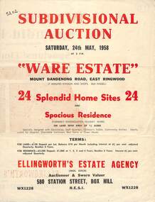
Flyer, Subdivisional Auction Sale Brochure, Ware Estate, East Ringwood, Vic. - 1958
Folded double-sided advertisement for auction of 24 home sites and existing residence on Saturday, 24th May, 1958, including locality map, subdivision layout, terms of sale, and summary of local facilities and services. Additional plan of lots 28-33 dated 26/10/60 by Licensed Surveyor for Kirkpatrick & Webber, 225 Maroondah Highway Ringwood headed Plan of Subdivision of part of Crown Allotment 26A Parish of Ringwood.Subdivision includes Mount Dandenong Road, Ware Crescent, Davey Drive, and Grey Road (later Grey Street). Timber residence included in the subdivision was formerly Ware Kindergarten Holiday Home. (Agent) Ellingworth's Estate Agency, 580 Station Street, Box Hill - (Phone) WX1228. -
 Bacchus Marsh & District Historical Society
Map, Maddingley Township, Parish of Parwan, circa 1890s
Maddingley is a locality or township within the broader township area of Bacchus Marsh. This map is not dated. However features in Maddingley which appeared in the 1880s and 1890s are present in the map, These include the Bacchus Marsh Railway Station and the Bacchus Marsh Showgrounds. The main residential and commercial area of Maddingley is shown on this map in an area bounded by Bacchus Street, Barry Street, Griffith Street and Maddingley Road. Other streets visible are Franklin Street, Inglis Street, Labilliere Street, McCrae Street, Moore Street and part of Station Street.A single page paper map showing land allotments, streets, rivers, creeks, park lands, the railway line and Bacchus Marsh railway station in the township of Maddingley. The map is pasted into a bound volume containing 76 maps or plans in total. bacchus marsh victoria maps, maddingley victoria maps, land use, maddingley victoria history -
 Bacchus Marsh & District Historical Society
Map, Maddingley Township, Parish of Parwan, County of Grant, 1856
Maddingley is a locality or township within the broader township area of Bacchus Marsh. This map is dated 1856 but is based on an earlier survey in 1843. The main area of Maddingley shown on this map is an area bounded by Bacchus Street, Moore Street, Griffith Street and Franklin Street. Other streets visible are Inglis Street, Labilliere Street, McCrae Street. The area to the east of Franklin Street is not sub-divided and is described as an 'alluvial flat. A single page paper map showing land allotments, streets, and natural watercourses in the township of Maddingley. The map is pasted into a bound volume containing 76 maps or plans in total. Two inscriptions: 1. A.J. Skene Surveyor, 1843. ; 2. Surveyor-General's Office Melbourne, Sept 6, 1856. (Lithographed by R. Meikle)bacchus marsh victoria maps, maddingley victoria maps, land use, maddingley victoria history -
 Bacchus Marsh & District Historical Society
Map, Plan of Survey of Part of Crown Allotment 9, Parish of Korkuperrimul, 1890
... Allotment 9, Parish of Korkuperrimul, 1890 Map Shire of Bacchus ...This map documents a transfer of an allotment of land in Clarke Street Bacchus Marsh in 1890. Clarke Street is located on the eastern side of Bacchus Marsh not far from Main Street and Crook Street. It is now known as Candeloro Street. The map indicates J. Booth as the owner of the land and H. Simpson as the occupier. Next to this allotment is a an allotment of land owned by J. Elmore,Single page map showing Crown allotment 9, Parish of Korkuperrimul, County of Bourke. Scale 100 feet to inch. Part of a set of maps which are pasted into a bound volume containing 76 maps or plans in total. High resolution digital image stored on BMDHS computer network. At bottom of map: I hereby certify that I have made this survey expressly for the purpose of an application under the Transfer of Land Statute that this plan is correct. Barry B???, Lic. Surveyor, 16.10.90bacchus marsh victoria maps, clarke street bacchus marsh maps -
 Ringwood and District Historical Society
Map - Plans of Subdivision, Part of Crown Allotments 35 & 39, Parish of Warrandyte
... & 39, Parish of Warrandyte Map Plans of Subdivision ...Survey maps of stages 1, 2 & 3 of residential allotments in Kalinda Road and Grayling Crescent, Ringwood, Victoria. (Undated, circa 1960). Some allotments are marked with real estate information and prices in pre decimal £s.Adshead & McGuire, Land Surveyors L.S. M.I.S. (Aust), 268 Albert Street East Melbourne (Ref 118/2a b &c) Tel 41-6960. The land colored blue is set apart for drainage & sewerage purposes. Reference Marks (R.M's) are Gal Iron Pipes 12"x1". Levels shown are to M.M.B.W. Datum. The land shown hatched is subject to innundation. -
 Bendigo Historical Society Inc.
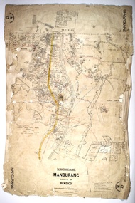
Map - MANDURANG, 10/11/1909
... MAP Bendigo parish plan Mandurang Map: Mandurang, County ...Map: Mandurang, County of Bendigo. Parish planmap, bendigo, parish plan, mandurang -
 Ringwood and District Historical Society
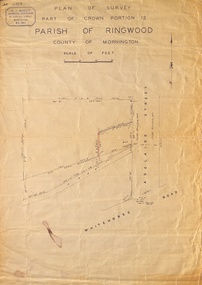
Map, Plan of Survey, Part of CP12, Adelaide Street, Ringwood, Circa 1920s
Undated map of part of commercial area in Parish of Ringwood, County of Mornington showing Adelaide Street, Whitehorse Road, and un-named laneway behind Whitehorse Road shops marked as Road, and New Road Alignment. Made by H.J. Macey, Licensed Surveyor 36 Narissa Street Burwood BX1917. -
 Ringwood and District Historical Society
Document - Real Estate Folder, Savernake Estate, Ringwood, Victoria - Stage two - circa 1967
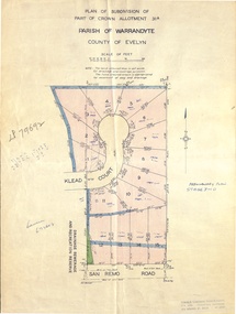
Plan of Subdivision PS79692, Part of Crown Allotment 31A Parish of Warrandyte, and advertisement for sale of residential allotments with map showing layout of Stage 2 of subdivision. Typewritten details for first and second release of Lots 10 to 16 with Terms of sale, stapled to two advertising flyers featuring map of estate showing Lots 1 to 20 on Evelyn Road, Cameron Road, Klead Court, and San Remo Road. Green slip included dated 6 July 1979 showing description of property at Lot 14 (no.4) San Remo Road, vendor - Judith Margaret Love and Lindsale Stephen Love, Cherry Tree Downs, Tarwin Lower 3456. Phone 056635390 Bus 056787203.Agent - C.E. Carter & Son, R.E.S.I. 126 Whitehorse Road, Ringwood. Telephones: 8706024, 8706830, 8702519, A.H.: 7233298, 8782648. Subdivision Plan stamped Donald Cameron Consultants Pty. Ltd., Consulting Engineers, 472 Bourke Street Melbourne - 67-2602. -
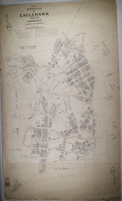
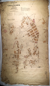
 Bendigo Historical Society Inc.
Map - BOROUGH OF EAGLEHAWK SHEET 2, 9/12/1902
... MAP Bendigo parish plan Borough of Eaglehawk Map: Borough ...Map: Borough of Eaglehawk, sheet No. 2. Parish planmap, bendigo, parish plan, borough of eaglehawk -
 Bendigo Historical Society Inc.
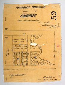
Map - PROPOSED TOWNSHIP PARISH OF CAMPASPE, 24th May 1875
... Map: Proposed Township, Parish of Campaspe(This has been... to the backing Map PROPOSED TOWNSHIP PARISH OF CAMPASPE ...Map: Proposed Township, Parish of Campaspe(This has been crossed out and 'Creek View' written above). Hand Draughted Parish plan Stapled to the backingmap, township, proposed township, campaspe, creek view -
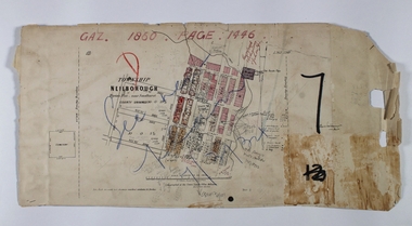
 Bendigo Historical Society Inc.
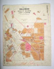
Map - TOWN OF INGLEWOOD, March 1946
... Map: Town of Inglewood, Parish of Inglewood, County..., Parish of Inglewood, County of Gladstone. Parish plan Map TOWN ...Map: Town of Inglewood, Parish of Inglewood, County of Gladstone. Parish planmap, gladstone, township, inglewood -
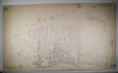
 Bendigo Historical Society Inc.
Map - BOROUGH OF EAGLEHAWK SHEET 1, 9/12/1902
... MAP Bendigo parish plan Borough of Eaglehawk Map: Borough ...Map: Borough of Eaglehawk, sheet No. 1, Parish of Sandhurst, County of Bendigo. Parish planmap, bendigo, parish plan, borough of eaglehawk -
 Bendigo Historical Society Inc.
Map - BOROUGH OF EAGLEHAWK SHEET 2, 9/12/1902
... MAP Bendigo parish plan Borough of Eaglehawk Map: Borough ...Map: Borough of Eaglehawk, Sheet No, 2. Parish planmap, bendigo, parish plan, borough of eaglehawk -
 Bendigo Historical Society Inc.
Map - BOROUGH OF EAGLEHAWK SHEET 3, Circa 1880's
... MAP Bendigo parish plan `Borough of Eaglhawk Map: Borough ...Map: Borough of Eaglehawk , sheet No. 3. Parish planmap, bendigo, parish plan, `borough of eaglhawk -
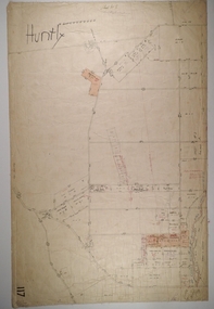 Bendigo Historical Society Inc.
Map - HUNTLY, Circa 1870's
... Map: Huntly, Hand draughted parish plan...MAP Bendigo parish plan Huntly Map: Huntly, Hand draughted ...Map: Huntly, Hand draughted parish planmap, bendigo, parish plan, huntly -
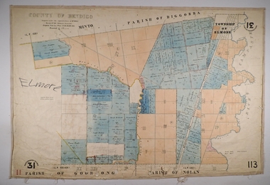 Bendigo Historical Society Inc.
Map - ELMORE, 3/03/1875
... MAP Bendigo parish plan Elmore W.H. Gregson Mr. Biers Map ...Map: Elmore, County of Bendigo. Parish plan Paper canvas backed. Compiled under the superintendence of Mr. BIERS November 12th W. H. GREGSON DRAUGHTSMAN Compiled from local plans 31.215.216.502.833. Examined by E. D. 27.11.74map, bendigo, parish plan, elmore, w.h. gregson, mr. biers -
 Lakes Entrance Historical Society
Book, Bombala and Districts Historical Society, Backyard History, 1993
A history of Bombala Shire New South Wales and district from official records parish plans, and anecdotes, produced for research purposes only. Illustrated with maps.settlers, township, genealogy -
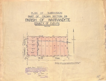 Ringwood and District Historical Society
Map - Plan of Subdivision, Part of Crown Section 24, Parish of Warrandyte, County of Evelyn - 1951
Survey map of residential allotments in Berringa Road and Milne Road, Park Orchards, Victoria. Russell Francis Kinnane, Licensed Surveyor, 4th October, 1951. -
 Ringwood and District Historical Society
Map - Plan of Subdivision, Part of Crown Section 24, Parish of Warrandyte, County of Evelyn - undated, circa 1951
Survey map of residential allotments in Milne Road, east of Berringa Road, Park Orchards, Victoria. -
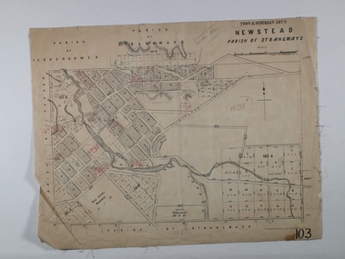 Bendigo Historical Society Inc.
Map - NEWSTEAD ALLOTMENTS, 10/06/1886
... MAP allotments Newstead Allotments Parish of Strangways Map ...Map: Town ans Suburban Lots, Newstead, Parish of Strangwaysmap, allotments, newstead , allotments, parish of strangways -
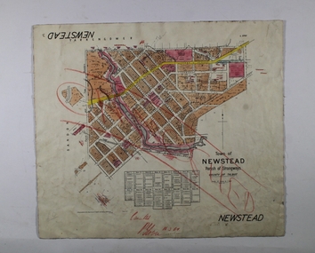 Bendigo Historical Society Inc.
Map - NEWSTEAD, 1/11/1939
... Map: Town of Newstead, Parish of Strangways, County...MAP Talbot township Newstead Parish of Strangways County ...Map: Town of Newstead, Parish of Strangways, County of Talbotmap, talbot, township, newstead, parish of strangways, county of talbot -
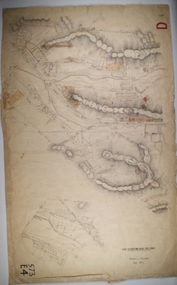
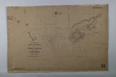 Bendigo Historical Society Inc.
Map - KOOYOORA, July 23rd 1857
... MAP township Kooyoora Allotments Parish of Kingower Map ...Map: The Township of Kooyoora and suburban allotments in the Parish of Kingower. This plan has been applied to a newer backingmap, township, kooyoora, allotments, parish of kingower -
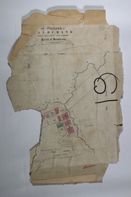
 Bendigo Historical Society Inc.
Map - NEILBOROUGH RAVENSWOOD, October 21 1859
Map:Township of Neilborough, Elysian Flat, near Sandhurst,County unnamed. Parish plan. Backing is a part of Ravenswood Township map.map, bendigo, neilborough, elysian flat, ravenswood -
 Bendigo Historical Society Inc.
Map - MANDURANG, No date visible
... MAP Bendigo parish plan Mandurang Laanecoorie Map: It has ...Map: It has the Village of Mandurang on one side and the Township of Laanecoorie on the reversemap, bendigo, parish plan, mandurang, laanecoorie -
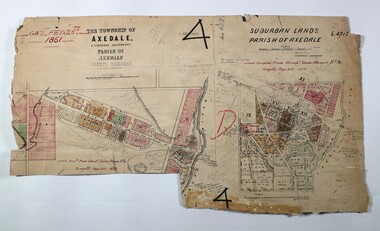 Bendigo Historical Society Inc.
Map - LOCAL AREA PLANS, See above
... MAP Bendigo parish plan Bridgewater Colbinnabbin Axedale ...Map: Compilation of maps: Town lots Bridgewater dated April 29 1871. Village of Colbinnabbin, dated 5 December 1866, Township of Axedale 1858 (Larritt). Suburban lands Axedale dated April 12 1871map, bendigo, parish plan, bridgewater, colbinnabbin, axedale, suburban lands -
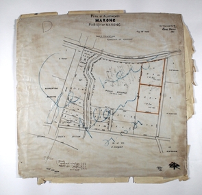 Bendigo Historical Society Inc.
Map - MARONG ALLOTMENTS, 25/08/1906
... MAP Bendigo parish plan Marong Parish of Marong Map: Plan ...Map: Plan of Allotments at Marong, Parish of Marong, County of Bendigo. Hand draughted mapmap, bendigo, parish plan, marong, parish of marong -
 Bendigo Historical Society Inc.
Map - PART OF THE BOROUGH OF EAGLEHAWK, 9/12/1902
... MAP Bendigo city streets Borough of Eaglehawk Parish ...Map: Part of the Borough of Eaglehawk, Parish of Sandhurst, County of Bendigo. Parish plan Canvas backed.map, bendigo, city streets, borough of eaglehawk, parish of sandhurst, county of bendigo -
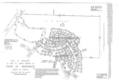 Ringwood and District Historical Society
Document - Subdivision Plan, LP83721 Part of Crown Portion 23, Parish of Warrandyte, County of Evelyn, Vol 8708 Fol 351, Vol 8745 Fol 148 and Vol 8751 Fol 034 - 1969
Double sided LANDATA Land Victoria 2-sheet plan printout dated 2009Sheet 1 map and Sheet 2 enlargement including Wonga Road, Holyrood Crescent, Harwick Close, Berkley Road, Frederic Drive, Kenwood Crescent, Adele Court and Marilyn Street, Ringwood. Markings also include LP83722 . -
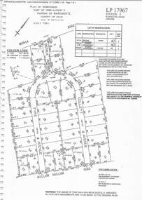 Ringwood and District Historical Society
Document - Subdivision Plan, LP17967 Part of Crown Allotment 33, Parish of Warrandyte, County of Evelyn, Vol 6141 Fol 054 - 1948
LANDATA Land Victoria plan printout dated 2008Map includes Wonga Road, Berea Avenue, Fyfe Avenue and Collett Avenue, Ringwood. Markings also include PS309215, LP143952, LP210020, LP24182, LP70960, SP29097, RP9235, SP19956 and LP113437.