Showing 855 items matching "parish plan"
-
 Ringwood and District Historical Society
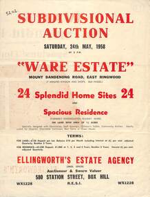
Flyer, Subdivisional Auction Sale Brochure, Ware Estate, East Ringwood, Vic. - 1958
Folded double-sided advertisement for auction of 24 home sites and existing residence on Saturday, 24th May, 1958, including locality map, subdivision layout, terms of sale, and summary of local facilities and services. Additional plan of lots 28-33 dated 26/10/60 by Licensed Surveyor for Kirkpatrick & Webber, 225 Maroondah Highway Ringwood headed Plan of Subdivision of part of Crown Allotment 26A Parish of Ringwood.Subdivision includes Mount Dandenong Road, Ware Crescent, Davey Drive, and Grey Road (later Grey Street). Timber residence included in the subdivision was formerly Ware Kindergarten Holiday Home. (Agent) Ellingworth's Estate Agency, 580 Station Street, Box Hill - (Phone) WX1228. -
 Bacchus Marsh & District Historical Society
Map, Maddingley Township, Parish of Parwan, circa 1890s
Maddingley is a locality or township within the broader township area of Bacchus Marsh. This map is not dated. However features in Maddingley which appeared in the 1880s and 1890s are present in the map, These include the Bacchus Marsh Railway Station and the Bacchus Marsh Showgrounds. The main residential and commercial area of Maddingley is shown on this map in an area bounded by Bacchus Street, Barry Street, Griffith Street and Maddingley Road. Other streets visible are Franklin Street, Inglis Street, Labilliere Street, McCrae Street, Moore Street and part of Station Street.A single page paper map showing land allotments, streets, rivers, creeks, park lands, the railway line and Bacchus Marsh railway station in the township of Maddingley. The map is pasted into a bound volume containing 76 maps or plans in total. bacchus marsh victoria maps, maddingley victoria maps, land use, maddingley victoria history -
 Bacchus Marsh & District Historical Society
Map, Maddingley Township, Parish of Parwan, County of Grant, 1856
Maddingley is a locality or township within the broader township area of Bacchus Marsh. This map is dated 1856 but is based on an earlier survey in 1843. The main area of Maddingley shown on this map is an area bounded by Bacchus Street, Moore Street, Griffith Street and Franklin Street. Other streets visible are Inglis Street, Labilliere Street, McCrae Street. The area to the east of Franklin Street is not sub-divided and is described as an 'alluvial flat. A single page paper map showing land allotments, streets, and natural watercourses in the township of Maddingley. The map is pasted into a bound volume containing 76 maps or plans in total. Two inscriptions: 1. A.J. Skene Surveyor, 1843. ; 2. Surveyor-General's Office Melbourne, Sept 6, 1856. (Lithographed by R. Meikle)bacchus marsh victoria maps, maddingley victoria maps, land use, maddingley victoria history -
 Bacchus Marsh & District Historical Society
Map, Plan of Survey of Part of Crown Allotment 9, Parish of Korkuperrimul, 1890
This map documents a transfer of an allotment of land in Clarke Street Bacchus Marsh in 1890. Clarke Street is located on the eastern side of Bacchus Marsh not far from Main Street and Crook Street. It is now known as Candeloro Street. The map indicates J. Booth as the owner of the land and H. Simpson as the occupier. Next to this allotment is a an allotment of land owned by J. Elmore,Single page map showing Crown allotment 9, Parish of Korkuperrimul, County of Bourke. Scale 100 feet to inch. Part of a set of maps which are pasted into a bound volume containing 76 maps or plans in total. High resolution digital image stored on BMDHS computer network. At bottom of map: I hereby certify that I have made this survey expressly for the purpose of an application under the Transfer of Land Statute that this plan is correct. Barry B???, Lic. Surveyor, 16.10.90bacchus marsh victoria maps, clarke street bacchus marsh maps -
 Ringwood and District Historical Society
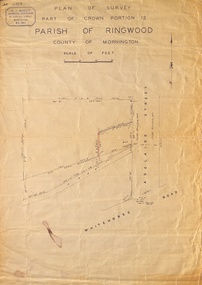
Map - Plans of Subdivision, Part of Crown Allotments 35 & 39, Parish of Warrandyte
... & 39, Parish of Warrandyte Map Plans of Subdivision ...Survey maps of stages 1, 2 & 3 of residential allotments in Kalinda Road and Grayling Crescent, Ringwood, Victoria. (Undated, circa 1960). Some allotments are marked with real estate information and prices in pre decimal £s.Adshead & McGuire, Land Surveyors L.S. M.I.S. (Aust), 268 Albert Street East Melbourne (Ref 118/2a b &c) Tel 41-6960. The land colored blue is set apart for drainage & sewerage purposes. Reference Marks (R.M's) are Gal Iron Pipes 12"x1". Levels shown are to M.M.B.W. Datum. The land shown hatched is subject to innundation. -
 Ringwood and District Historical Society
Map, Plan of Survey, Part of CP12, Adelaide Street, Ringwood, Circa 1920s
Undated map of part of commercial area in Parish of Ringwood, County of Mornington showing Adelaide Street, Whitehorse Road, and un-named laneway behind Whitehorse Road shops marked as Road, and New Road Alignment. Made by H.J. Macey, Licensed Surveyor 36 Narissa Street Burwood BX1917. -
 Ringwood and District Historical Society
Document - Real Estate Folder, Savernake Estate, Ringwood, Victoria - Stage two - circa 1967
Plan of Subdivision PS79692, Part of Crown Allotment 31A Parish of Warrandyte, and advertisement for sale of residential allotments with map showing layout of Stage 2 of subdivision. Typewritten details for first and second release of Lots 10 to 16 with Terms of sale, stapled to two advertising flyers featuring map of estate showing Lots 1 to 20 on Evelyn Road, Cameron Road, Klead Court, and San Remo Road. Green slip included dated 6 July 1979 showing description of property at Lot 14 (no.4) San Remo Road, vendor - Judith Margaret Love and Lindsale Stephen Love, Cherry Tree Downs, Tarwin Lower 3456. Phone 056635390 Bus 056787203.Agent - C.E. Carter & Son, R.E.S.I. 126 Whitehorse Road, Ringwood. Telephones: 8706024, 8706830, 8702519, A.H.: 7233298, 8782648. Subdivision Plan stamped Donald Cameron Consultants Pty. Ltd., Consulting Engineers, 472 Bourke Street Melbourne - 67-2602. -
 Ringwood and District Historical Society
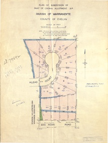
Map - Plan of Subdivision, Part of Crown Section 24, Parish of Warrandyte, County of Evelyn - 1951
Survey map of residential allotments in Berringa Road and Milne Road, Park Orchards, Victoria. Russell Francis Kinnane, Licensed Surveyor, 4th October, 1951. -
 Ringwood and District Historical Society
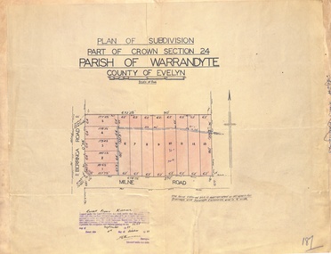
Map - Plan of Subdivision, Part of Crown Section 24, Parish of Warrandyte, County of Evelyn - undated, circa 1951
Survey map of residential allotments in Milne Road, east of Berringa Road, Park Orchards, Victoria. -
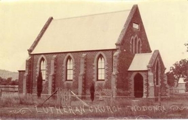 Wodonga & District Historical Society Inc
Photograph - Saint John's Lutheran Church, Wodonga
From the mid-1860s families of German ancestry arrived in the Wodonga district, travelling in groups from South Australia. The majority of these people were of the Lutheran religion. At first there was no Lutheran pastor or church in the area and they held services under the gum trees or in their homes once they had been built. The early arrivals included the Haeusler, Klinge, Bartel, Rothe and Paech families. They were later joined by members of the Muller, Lange, Pumpa, Lobbe, Heckendorf, Zeinert, Schubert, Schuster, Schubert and Terlich families amongst others. The first Lutheran Church was built in Havelock Street, Wodonga and was dedicated in 1875. This building was used for approximately 90 years until it was demolished and replaced by a temporary building and then a second church which was dedicated in 1978. The Ovens and Murray Advertiser on 4th August 1874 reported "The Rev. Goessling pastor of the German Lutheran Church, Gerogery has laid the foundation stone of the new church for the members of his denomination residing at Wodonga, in accordance with the rights of the church. The building was to be 30 feet by 20 feet and 14 feet high, of brick with white facings and Gothic windows. There was to be a porch and vestry, one at either end, measuring 8 feet by 10 feet". Plans were initiated to build a new church from the late 1990s. After many years of planning and hard work, the last service in the Saint John’s Lutheran Church in Havelock Street was held on Sunday 7th May 2023 and a new Church was constructed. From 14th May 2023 the Parish held its worship services in Luther Hall at Victory Lutheran College in Drage Road, West Wodonga. The new Saint John’s Church was consecrated on 18 August 2024.This photo is significant because it depicts the original Lutheran Church in Wodonga.A black and white photograph of an old stone church building.Lutheran Church Wodongawodonga churches, lutheran church wodonga -
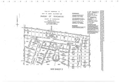 Ringwood and District Historical Society
Document - Subdivision Plan, Part of Crown Allotment 32B Parish of Ringwood, County of Mornington Vol 6051 Fol 111 - LP26857
LANDATA Land Victoria 2-sheet plan printout dated 9/11/1953.Sheet 1 includes Lynwood Avenue, Isabel Avenue, Braewood Avenue, Maple Court, and Heathwood Street, Ringwood East, Vic. Sheet 2 includes Braewood Avenue, Rotherwood Avenue, and Heathwood Street, Ringwood East, Vic. Additional markings include LP46598, CP173330, LP86847, LP213448, LP217511, LP207217, LP56241. -
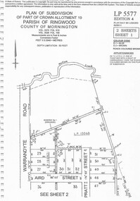 Ringwood and District Historical Society
Document - Subdivision Plan, Part of Crown Allotment 19 Parish of Ringwood, County of Mornington Vol 3375 Fol 910 & Vol 3526 Fol 159 - LP5577
LANDATA Land Victoria 2-sheet plan printout dated 6/9/2011.Sheet 1 includes Warrandyte Road, Aird Street, and Pratt Street, Ringwood, Vic. Additional markings include LP19568 Sheet 2 includes Warrandyte Road, Aird Street, Pratt Street, and White Horse Road, Ringwood, Vic. Additional markings include SP25671H, CP100154, LP10519, LP28996 and P51182. -
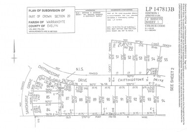 Ringwood and District Historical Society
Document - Subdivision Plan, Part of Crown Section 20 Parish of Warrandyte, County of Evelyn Vol 9622 Fol 554 - LP147813B
LANDATA Land Victoria 2-sheet plan printout dated 3/12/1985.Sheet 1 includes Sandhurst Grove and Chittingstone Drive (later Braden Brae Drive) Warranwood, Vic. Sheet 2 includes Standen Court and Chittingstone Drive (later Braden Brae Drive) Warranwood, Vic. -
 Ringwood and District Historical Society
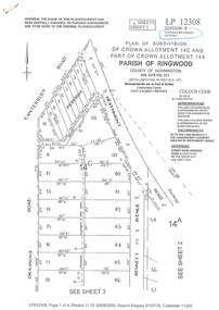
Document - Subdivision Plan, LP12308 Crown Allotment 14C and Part of Crown Allotment 14A Parish of Ringwood, County of Mornington Vol 5378 Fol 511 - Circa 1927
LANDATA Land Victoria 4-sheet plan printout dated 2009.Sheet 1 includes Canterbury Road, Heathmont Road, Dickasons Road and Bennett Avenue, Heathmont. Additional markings include PC353066. Sheet 2 includes Heathmont Road, Bennett Avenue and Orchid Street, Heathmont. Additional markings include PS326369 and SP24567. Sheet 3 includes Dickasons Road and Bennett Avenue, Heathmont. Additional markings include LP46776, SP28005 and PS335189. Sheet 4 includes Dickasons Road, Bennett Avenue and Orchid Street, Heathmont. Additional markings include SP25998, SP31080, SP31780, SP25968, SP25969 and LP46475. -
 Ringwood and District Historical Society
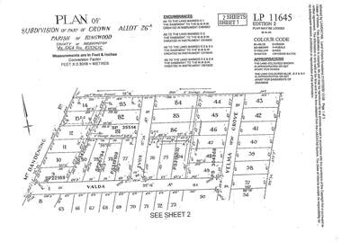
Document - Subdivision Plan, LP11645 Part of Crown Allotment 26A, Parish of Ringwood, County of Mornington Vol 5164 Fol 1032616 - 1926
LANDATA Land Victoria 2-sheet plan printout dated 2009Sheet 1 includes Mount Dandenong Road, Valda Avenue and Velma Grove, Ringwood East. Additional markings include SP35514, SP22189, SP34206, SP35514, SP26794, PS319109, PS319010 and PS304868. Sheet 2 includes Mount Dandenong Road, Valda Avenue, Mirabel Avenue and Velma Grove, Ringwood East. Additional markings include SP26430, SP25320, PS341575, PS319110, PS319010, LP48415, SP22732, SP25844, PS304936 and PS304937. -
 Ringwood and District Historical Society
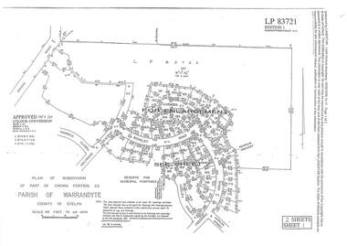
Document - Subdivision Plan, LP83721 Part of Crown Portion 23, Parish of Warrandyte, County of Evelyn, Vol 8708 Fol 351, Vol 8745 Fol 148 and Vol 8751 Fol 034 - 1969
Double sided LANDATA Land Victoria 2-sheet plan printout dated 2009Sheet 1 map and Sheet 2 enlargement including Wonga Road, Holyrood Crescent, Harwick Close, Berkley Road, Frederic Drive, Kenwood Crescent, Adele Court and Marilyn Street, Ringwood. Markings also include LP83722 . -
 Ringwood and District Historical Society
Document - Subdivision Plan, LP113220 Part of Crown Allotments 35 & 39B, Parish of Warrandyte, County of Mornington, Vol 6421 Fol 183 & 184 - 1965
LANDATA Land Victoria 2-sheet plan printout dated 2009Sheet 1 includes Kalinda Road, Ringwood. Additional markings include LP113117. Sheet 2 includes Kalinda Road and Maroondah Highway, Ringwood. Additional markings include LP86253. Both sheets include location of Drainage and Sewerage Reserve along Mullum Mullum Creek. -
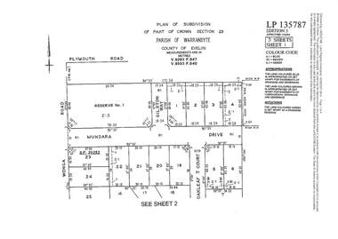 Ringwood and District Historical Society
Document - Subdivision Plan, LP135787 Part of Crown Section 23, Parish of Warrandyte, County of Evelyn, Vol 9293 Fol 947 and Vol 9503 Fol 640 - 1984
LANDATA Land Victoria 3-sheet plan printout dated 2007Sheet 1 includes Wonga Road, Mundara Drive, Gilston Way and Oakleaf Court, Ringwood. Additional markings include SP25252. Sheet 2 includes Wonga Road and Oakleaf Court, Ringwood. Sheet 3 includes Wonga Road, Wyndarra Court and Gem Close, Ringwood. -
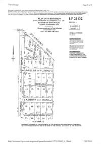 Ringwood and District Historical Society
Document - Subdivision Plan, LP21132 Part of Crown Allotment 14A & 14B, Parish of Ringwood, County of Mornington Vol 4929 Fol 657 - (Undated, circa 1920s/30)
LANDATA Land Victoria 2-sheet plan printout dated 2010.Sheet 1 includes Dickasons Road, Barnic Road, Muller Road and Kenbry Road, Heathmont. Sheet 2 includes Barnic Road and Possum Lane, Heathmont. Additional markings include LP83779. -
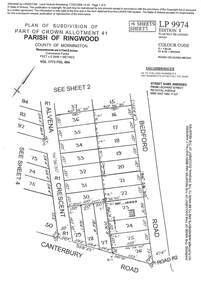 Ringwood and District Historical Society
Document - Subdivision Plan, LP9974 Part of Crown Allotment 41, Parish of Ringwood, County of Mornington Vol 1773 Fol 464 - 1924
LANDATA Land Victoria 4-sheet plan printout dated 2009Sheet 1 includes Alvena Crescent, Bedford Road and Canterbury Road, Heathmont. Additional markings include RP16869. Sheet 2 includes Alvena Crescent and Bedford Road, Heathmont. Additional markings include PS318390 and CP161633. Sheet 3 includes Bedford Road, Alvena Crescent and Royal Avenue, Heathmont. Additional markings include RP454. Street name amended from Leonard Street to Royal Avenue Vide Gaz 1962 P.427. Sheet 4 includes Alvena Crescent, Royal Avenue, Coleman Street and Canterbury Road, Heathmont. Additional markings include SP27861, PS305057, RP10566, SP34722 and LP116573. -
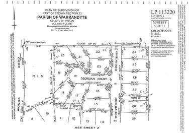 Ringwood and District Historical Society
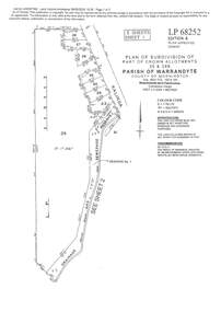
Document - Subdivision Plan, LP113220 Part of Crown Section 23, Parish of Warrandyte, County of Evelyn Vol 8970 Fol 687 - 1975
LANDATA Land Victoria 2-sheet plan printout dated 2009Sheet 1 includes Wonga Road, Holyrood Crescent and Georgian Court, Ringwood. Sheet 2 includes Wonga Road, Holyrood Crescent and Stonington Place, Ringwood. -
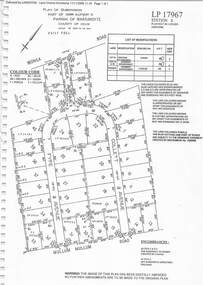 Ringwood and District Historical Society
Document - Subdivision Plan, LP17967 Part of Crown Allotment 33, Parish of Warrandyte, County of Evelyn, Vol 6141 Fol 054 - 1948
LANDATA Land Victoria plan printout dated 2008Map includes Wonga Road, Berea Avenue, Fyfe Avenue and Collett Avenue, Ringwood. Markings also include PS309215, LP143952, LP210020, LP24182, LP70960, SP29097, RP9235, SP19956 and LP113437. -
 Ringwood and District Historical Society
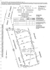
Document - Subdivision Plan, LP40417 Part of Crown Portions 16 & 18, Parish of Ringwood, County of Mornington, Vol 6231 Fol 035 and Vol 8139 Fol 248 - 1957
LANDATA Land Victoria plan printout dated 2008Map includes Heathmont Road, Heathmont, with allotments adjoining Railway Reserve. Other markings include LP95632NS. -
 Ringwood and District Historical Society
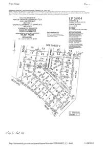
Document - Subdivision Plan, LP26914 Multiple Crown Allotments, Parish of Ringwood, County of Mornington, Vol 8021 Fol 053 - 1954
LANDATA Land Victoria plan printout dated 2010Part of Crown Allotments 1, 1A, 2, 3, 4, 5, 6, 7, 8, 9, 10, 55, 56, 57. Section C Crown Allotments 3, 12 & part of 2. Section B Map includes Bedford Road, Government Road (later Bedford Park Road then Hill Street), Marwarra Street and Tooronga Road, Ringwood. (Sheet 1 of 2 - Sheet 2 not included with collection). -
 Ringwood and District Historical Society
Document - Subdivision Plan, LP10477 Parish of Warrandyte, County of Evelyn, Vol 2453 Fol 574 - 1924
LANDATA Land Victoria plan printout circa 2010Part of Crown Allotment 30. Map includes Warrandyte Road, Kennedy Avenue and Wonga Road, Ringwood. Street name amended from Wonga Road to Loughnan Road 1940. Other markings include CP102182, CP171386, LP127934, PS349846, RP7582, PS309312,RP8679 and CP106336. -
 Ringwood and District Historical Society
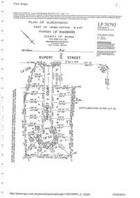
Document - Subdivision Plan, LP76792 Part of Crown Portions 19 & 20A, Parish of Ringwood, County of Bourke, Vol 8382 Fol 140 - 1967
LANDATA Land Victoria plan printout dated 2010Map includes Rupert Street and Prospect Court, Ringwood. -
 Linton and District Historical Society Inc
Mining survey document, Mining Survey Document, 1890
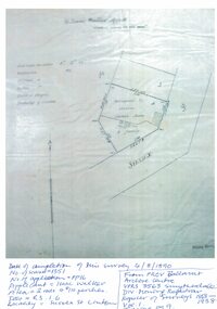
Document drawn up in relation to an application for a mining lease made by Isaac Walker of Linton. Application no. PP16, Lease no. 1351. Application was made for a mining lease on land in Sussex Street, Linton, which was occupied by Sarah Dawe and family. Original document is held at PROV Ballarat. Item and series details are recorded in handwriting on the lower part of the document.Photocopy of original document, which shows a plan of Allotments 3 & 4, Section 1A, Township of Linton, Parish of Argyle.mining applications, mining leases, plans, documents, isaac walker, dawe family, sarah dawe née carpenter -
 Linton and District Historical Society Inc
Documents - purchase of land, Purchase of land by David McFadzean, 1872 - Allotment A1A, Township of Linton, Parish of Argyle
The land was purchased by David McFadzean under the 42nd section of the Amending Land Act, 1865. This allowed long-term tenants ("licensees") of government-held land to purchase ("alienate") the land. The allotment is in present-day Jackson Street, Linton.Twelve A4-size photocopies of documents relating to the purchase of an allotment of land - Allotment A1A, measuring 5 acres, 3 roods and 37 perches - within the boundaries of the Township of Linton. First page is headed "SECTION 31, "LAND ACT 1869". Documents include David McFadzean's application to purchase, notes made about the land and the application by officers of the Board of Land and Works, a plan of the allotment, and information about purchase price and fees.allotment a1a township of linton, david mcfadzean, victoria. amending land act 1865, conveyance, land sales, land purchases, documents and records, james beament -
 Bendigo Historical Society Inc.
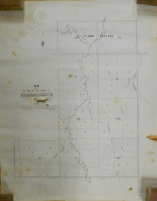
Document - MARKS COLLECTION: STRATHFIELDSAYE PLAN 1854
Plan drawn on light paper. Written on LH side of plan 'Plan of Part of the Parish of Strathfieldsaye 1854. Scale (shown) Lithographed at the Surveyor Generals Office, Melbourne July 10th. By I. Jones'. Plan shows Emu Creek and Village Reserve at top of plan, Shepherd's Creek on RH side, Parish Boundary Line on RH and bottom of plan.map, bendigo, shire of strathfieldsaye 1854 -
 Ringwood and District Historical Society
Document - Subdivision Map, Part of Crown Portion 22 Parish of Ringwood, County of Mornington. Vol 1915 Fol 827 - LP2427
LANDATA Land Victoria 4-sheet plan dated January 2003 - copy of original 1889 subdivision, amended with 1947 amendments by Assistant Registrar of Titles.Sheet 1 includes Main Lilydale Road (later Old Lilydale Road), Wandin Road (later Mount Dandenong Road), and Joseph Street, Ringwood East. Additional Plan markings SP30844, SP32804, LP144251, PS332061, PS305232. Sheet 2 includes Main Lilydale Road (later Old Lilydale Road), Wandin Road (later Mount Dandenong Road), and Dynes Street, Ringwood East. Additional Plan markings LP43708, LP44231, LP124702. Sheet 3 includes Main Lilydale Road (later Old Lilydale Road), Dynes Street, Albert Street (later Wyrunga Street), and Carcoola Road, Ringwood East. Additional Plan markings LP114181, LP114180, LP18261, LP214030, LP67300, PS354509, PS335500. Sheet 4 includes Main Lilydale Road (later Old Lilydale Road), Albert Street (later Wyrunga Street), and Carcoola Road, Ringwood East. Additional Plan markings PS315494, PS319495.