Showing 1627 items matching "river yarra"
-
 Kew Historical Society Inc
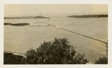
Photograph - Victorian Canoe Club, Mallacoota trip, 1935, 1935
... Canoeing on the River Yarra at Melbourne was an important... Canoeing on the River Yarra at Melbourne was an important ...Canoeing on the River Yarra at Melbourne was an important and widespread recreational pursuit for Melbournians, especially in the first half of the twentieth century. The Victorian Canoe Club was formed in 1912 at a meeting in Melbourne and its first committee elected in the same year. Records indicate that the Club continued into at least the 1950s .The photos in this album are historically and socially significant as a record of recreational activities in the first half of the twentieth century. A number of photographs in the album provide views of sections of the Yarra, as well as areas in regional Victoria, that may otherwise be unavailable.One of 12 sepia [faded] photographs of members of the Victorian Canoe Club. This photo was taken by a member of the club on a later trip to Mallacoota in 1935."Mallacoota trip, 1935"victorian canoe club, travel -- 1930s, mallacoota -
 Kew Historical Society Inc
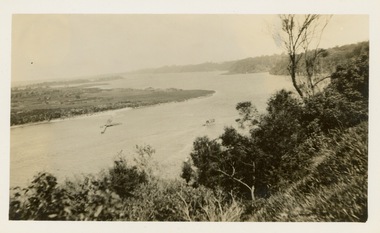
Photograph - Victorian Canoe Club, Gippsland Lakes, 1935
... Canoeing on the River Yarra at Melbourne was an important... Canoeing on the River Yarra at Melbourne was an important ...Canoeing on the River Yarra at Melbourne was an important and widespread recreational pursuit for Melbournians, especially in the first half of the twentieth century. The Victorian Canoe Club was formed in 1912 at a meeting in Melbourne and its first committee elected in the same year. Records indicate that the Club continued into at least the 1950s .The photos in this album are historically and socially significant as a record of recreational activities in the first half of the twentieth century. A number of photographs in the album provide views of sections of the Yarra, as well as areas in regional Victoria, that may otherwise be unavailable.One of 12 sepia [faded] photographs of members of the Victorian Canoe Club. This photo was taken by a member of the club on a later trip to the Gippsland Lakes and Mallacoota in 1935."Gippsland Lakes"victorian canoe club, travel -- 1930s, gippsland lakes -
 Kew Historical Society Inc
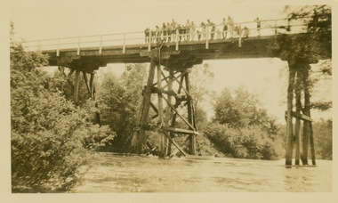
Photograph - Victorian Canoe Club, Salvaging wrecked canoe, 1930–35
... Canoeing on the River Yarra at Melbourne was an important... Canoeing on the River Yarra at Melbourne was an important ...Canoeing on the River Yarra at Melbourne was an important and widespread recreational pursuit for Melbournians, especially in the first half of the twentieth century. The Victorian Canoe Club was formed in 1912 at a meeting in Melbourne and its first committee elected in the same year. Records indicate that the Club continued into at least the 1950s .The photos in this album are historically and socially significant as a record of recreational activities in the first half of the twentieth century. A number of photographs in the album provide views of sections of the Yarra, as well as areas in regional Victoria, that may otherwise be unavailable.One of 12 sepia [faded] photographs of members of the Victorian Canoe Club. This photo was taken by a member of the club showing club members on a canoeing trip standing on a trestle bridge, with others, attempting to salvage a wrecked canoe."Salvaging wrecked canoe"victorian canoe club, travel -- 1930s, canoeing -
 Ringwood and District Historical Society
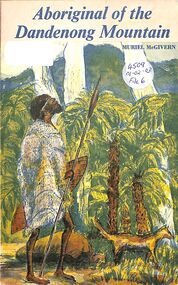
Book, Aboriginal of the Dandenong Mountain - Muriel McGivern
... about the foothills of the Dandenongs and the Upper Yarra River... and the Upper Yarra River Aboriginal of the Dandenong Mountain - Muriel ...Story of the Aborigines whose hunting and cult sites lay about the foothills of the Dandenongs and the Upper Yarra River -
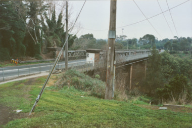 Kew Historical Society Inc
Photograph - Former Chandler Highway Bridge, 2001
... constructed for the Outer Circle Railway to bridge the Yarra River... to bridge the Yarra River between East Kew and Fairfield stations... for the Outer Circle Railway to bridge the Yarra River between East Kew ...The heritage listed Fairfield Bridge was originally constructed for the Outer Circle Railway to bridge the Yarra River between East Kew and Fairfield stations. In the 1930s it was converted for vehicular traffic. In the 2010s a new concrete bridge was erected beside it to increase vehicular capacity. Original colour print positive of the (former) Chandler Highway bridge in 2001. The point of view is from the Fairfield side of the river looking towards Kew. The heritage listed bridge was originally constructed for the Outer Circle Railway to bridge the Yarra River between East Kew and Fairfield stations. In the 1930s it was converted for vehicular traffic. In the 2010s a new concrete bridge was erected beside it to increase vehicular capacity. Ink inscription on reverse: "Chandler Highway bridge / (Originally Outer Circle Railway Bridge) / From Fairfield side towards Kew / July 2001"bridges -- kew (vic), fairfield bridge, chandler highway bridge, outer circle railway viaduct -
 University of Melbourne, Burnley Campus Archives
Newspaper - Newspaper Cutting, The Age, Victorian Horticultural Society, 1862
... Nic Station to the Gardens and River Yarra.... Richmond Park, past Pic Nic Station to the Gardens and River Yarra ...(1) Photocopy of article in "The Age" 30 January, 1862 p7. (2) Similar article from "the Argus" 30 January, 1962 p4. Description of the annual general meeting of the Victorian Horticultural Society. Description of a competition for a design and that the decorative part of the garden was nearly complete and open to the public. Donors of plants named including Rule (Californian Redwood?) Extension of Swan Street through Richmond Park, past Pic Nic Station to the Gardens and River Yarra.the age, the argus, victorian horticultural society, horticultural society of victoria, monthly meeting, competition for design of experimental gardens, burnley gardens, rule, californian redwood, donations of plants, pic nic station -
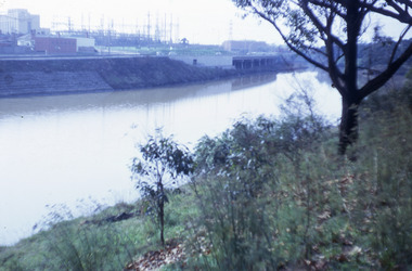
 Port Melbourne Historical & Preservation Society
Photograph - Loading gypsum, Dock No 6, Yarraville, Glen Stuart, 17 May 2003
... Yarraville, taken from across Yarra River... No 6 Yarraville, taken from across Yarra River Photograph ...Colour photo of cranes used for loading gypsum on Dock No 6 Yarraville, taken from across Yarra Riverpiers and wharves -
 Robin Boyd Foundation
Slide, Robin Boyd, 1967
... Colour slide in a mount. Possibly Yarra river across... river across to Richmond from Alexandra Avenue, South Yarra ...Colour slide in a mount. Possibly Yarra river across to Richmond from Alexandra Avenue, South Yarra, Victoria, AustraliaMade in Australia / 30 / JUN 67M6 / Encircled 48 (Handwritten)slide, robin boyd -
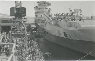 Port Melbourne Historical & Preservation Society
Photograph - British aircraft carrier HMS Indefatigable, Station Pier, Port Melbourne, Roy Liebig, Jan 1946
... the river Yarra and berthed at South Wharf.... at outer east. The Tuscan and Armada proceeded up the river Yarra ...On Wednesday 23 Jan 1946 British aircraft carriers HMS Indefatigable, HMS Implacable and HMS Glory escorted by destroyers HMS Tuscan and HMS Armada arrived in Melbourne. Indefatigable berthed at outer west Station Pier, Glory at inner east and Implacable at outer east. The Tuscan and Armada proceeded up the river Yarra and berthed at South Wharf.A series of photographs taken by Roy Liebig in the 1940s Hard copy and digital. British aircraft carrier HMS Indefatigable at the outer west berth of Station Pier in Jan 1946. The photo shows many visitors on the pier.maritime, war - world war ii, roy liebig, karen bowden, piers and wharves - station pier, hms indefatigable -
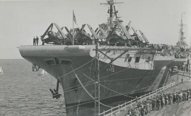 Port Melbourne Historical & Preservation Society
Photograph - British aircraft carrier HMS Glory, Station Pier, Port Melbourne, Roy Liebig, Jan 1946
... the river Yarra and berthed at South Wharf.... at outer east. The Tuscan and Armada proceeded up the river Yarra ...On Wednesday 23 Jan 1946 British aircraft carriers HMS Indefatigable, HMS Implacable and HMS Glory escorted by destroyers HMS Tuscan and HMS Armada arrived in Melbourne. Indefatigable berthed at outer west Station Pier, Glory at inner east and Implacable at outer east. The Tuscan and Armada proceeded up the river Yarra and berthed at South Wharf.A series of photographs taken by Roy Liebig in the 1940s Hard copy and digital. British aircraft carrier HMS Glory at the inner east berth of Station Pier in Jan 1946. The photo shows aircraft (with folded wings) on the deck of the carrier, many visitors on the pier and the superstructure of HMS Implacable berthed behind at outer east.maritime, war - world war ii, roy liebig, karen bowden, piers and wharves - station pier, hms glory, hms implacable -
University of Melbourne, Burnley Campus Archives
Slide, Alan L. Mitchell
... ) towards Yarra River....) towards Yarra River. Slide Alan L. Mitchell ...Looking across Oak Tree Lawn (showing at top of photo) towards Yarra River.alan l. mitchell, burnley gardens, oak tree lawn -
 Kew Historical Society Inc
Programme, Kew Canoe Carnival, 1910
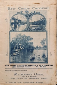
... on the River Yarra on February 11th. The location was at the Asylum... on the River Yarra on February 11th. The location was at the Asylum ...An item from an outstanding and diverse photographic collection, assembled by members of the Christian and Washfold families of Kew.Rare programme for what was once an annual event in Kew with important, possibly unique photos of sites in Kew and on the Yarra.Programme for the 1910 Kew Canoe Carnival which was held on the River Yarra on February 11th. The location was at the Asylum Reserve at the old white bridge (the precursor of Kane's Bridge). Funds were raised in Aid of the Annual Treat to Kew and Yarra Bend Patients (and the Carnival fund). The booklet includes details of the programme, numerous advertisements and rare and important historic photographs of the district including: the Willsmere Park Dairy, the Glen Tea Gardens at Hawthorn, the Pipe Bridge, the Kew Boat Sheds (Macauley's), and Rudder Grange boat house.christian-washfold collection, kew canoe club, kew canoe carnivals -
 Kew Historical Society Inc
Map, MMBW, MMBW Plan No.39 Kew & Heidelberg, 1900-1910
... Asylum, in the west by the River Yarra [and the later added Yarra... Street and the Kew Lunatic Asylum, in the west by the River Yarra ...The Melbourne and Metropolitan Board of Works (MMBW) was established by an act of the Victorian Parliament in 1890 to prepare for and to implement a sewerage and water reticulation system across what was then inner Melbourne, its surrounding and middle distance suburbs, including Kew. The MMBW was disbanded in 1991.The map collection of the Kew Historical Society has at its core the historic maps assembled and originally stored in the City Engineer's Department of the City of Kew. These include maps in a number of scales. The vast majority of maps were produced by the MMBW in the first two decades of the twentieth century, and are solid working maps, backed by linen for durability. These maps are historically significant to Kew, the City of Boroondara and to the history of the development of state utilities in Victoria. A number of the Kew maps have additional details added by former municipal officers, including the levels reached by various floods. As these were working documents, information was added to them long after the period of their initial production and distribution.Early map of part of the Borough of Kew, created in the first decade of the twentieth century, at a scale 160 ft to 1 inch. The map covers what was then the north western section of Kew, bordered on its north by Wills Street and the Kew Lunatic Asylum, in the west by the River Yarra [and the later added Yarra Boulevard] , by Princess Street in the East and Holroyd Street in the south. The map shows the extent of urban development by that time, prominent institutions and the outlines of built structures in the municipality. Contour lines were added in ink to the map at a later stage.MELBOURNE AND METROPOLITAN BOARD OF WORKS / PLAN NO. 39 / KEW & HEIDELBERGmelbourne & metropolitan board of works, mmbw maps, mmbw plans, borough of kew, cartography -
 University of Melbourne, Burnley Campus Archives
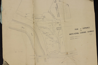
Plan, Plan of Entrance to Horticultural Gardens Burnley, 1932
... Superintendent dated 08.12.1932 'Re Proposed Boulevard Along the River...University of Melbourne, Burnley Campus Archives 500 Yarra ...Copy of plan photographed at the Public Records Office Victoria. (1) Hand drawn plan signed by A.W. Jessep 8/12/32 with 'Suspected Roadway' and ' Suggested Roadway'. Scale 1 inch - 1 chain. Trees on East side named. (2) Memorandum to The Agricultural Superintendent dated 08.12.1932 'Re Proposed Boulevard Along the River Yarra' from the Principal A.W. Jessep. Plan had been to put road through the Lagoon Paddock and he suggested the route outside the Burnley College grounds.prov, burnley gardens, a.w. jessep -
Federation University Historical Collection
Book, Beyond Rhetoric: University - Community engagement in Victoria
... on the front cover. Melbourne Arts Centre, Sky view of Yarra River.... Melbourne Arts Centre, Sky view of Yarra River and more. Beyond ...University - Community enagagement partnerships survey analysedRed and black covered book with pictures of buildings on the front cover. Melbourne Arts Centre, Sky view of Yarra River and more.non-fictionUniversity - Community enagagement partnerships survey analysed beyond rhetoric, university community enagagement, alexandra winter, john wiseman, bruce muirhead, anne badenhorst, david birch, catherine burnheim, brian galligan, ann gervasoni, david jones, anne langworthy, john mcdonald, winsome roberts, maureen rogers, keith boast -
Port Melbourne Historical & Preservation Society
Photograph - Moreton Bay, outbound in the Yarra, Glen Stuart, 1950s
... in Yarra River... 1950s: Moreton Bay, outbound in Yarra River Photograph Moreton ...One of nine photographs taken of various ships at Port Melbourne and river berths in the early 1950s: Moreton Bay, outbound in Yarra Rivertransport - shipping, moreton bay -
 Kew Historical Society Inc
Map, MMBW, MMBW Town of Kew, 1910-21
... on its north and west by the River Yarra, by Burke Road... on its north and west by the River Yarra, by Burke Road ...The Melbourne and Metropolitan Board of Works (MMBW) was established by an act of the Victorian Parliament in 1890 to prepare for and to implement a sewerage and water reticulation system across what was then inner Melbourne, its surrounding and middle distance suburbs, including Kew. The MMBW was disbanded in 1991.The map collection of the Kew Historical Society has at its core the historic maps assembled and originally stored in the City Engineer's Department of the City of Kew. These include maps in a number of scales. The vast majority of maps were produced by the MMBW in the first two decades of the twentieth century, and are solid working maps, backed by linen for durability. These maps are historically significant to Kew, the City of Boroondara and to the history of the development of state utilities in Victoria. A number of the Kew maps have additional details added by former municipal officers, including the levels reached by various floods. As these were working documents, information was added to them long after the period of their initial production and distribution.Early map of the Town of Kew, created after 1910, at a scale 440 ft to 1 inch. The 'assembled' map by the City of Kew Engineer's Department includes scaled down copies of The Melbourne and Metropolitan Board of Works maps, Nos. 39, 40, 64, 65, 66, 67, 68, and 117. The map covers the entirety of the Town of Kew, bordered on its north and west by the River Yarra, by Burke Road in the East and Barkers Road in the south. The map shows the extent of urban development by that time, prominent institutions and the outlines of built structures in the municipality. TOWN OF KEW / SCALE 400 FEET TO 1 INCHmelbourne & metropolitan board of works, mmbw maps, mmbw plans, town of kew, cartography -
 Kew Historical Society Inc
Map, MMBW, MMBW Plan No.40 Collingwood & Kew, 1900-1910
... by Walmer Street and the River Yarra, by High Street South... Park Road, in the west by Walmer Street and the River Yarra ...The Melbourne and Metropolitan Board of Works (MMBW) was established by an act of the Victorian Parliament in 1890 to prepare for and to implement a sewerage and water reticulation system across what was then inner Melbourne, its surrounding and middle distance suburbs, including Kew. The MMBW was disbanded in 1991.The map collection of the Kew Historical Society has at its core the historic maps assembled and originally stored in the City Engineer's Department of the City of Kew. These include maps in a number of scales. The vast majority of maps were produced by the MMBW in the first two decades of the twentieth century, and are solid working maps, backed by linen for durability. These maps are historically significant to Kew, the City of Boroondara and to the history of the development of state utilities in Victoria. A number of the Kew maps have additional details added by former municipal officers, including the levels reached by various floods. As these were working documents, information was added to them long after the period of their initial production and distribution.Early map of part of the Borough of Kew, created in the first decade of the twentieth century, at a scale 160 ft to 1 inch. The map covers what was then the south western section of Kew, bordered on its north by Studley Park Road, in the west by Walmer Street and the River Yarra, by High Street South and Princess Street in the East and Barkers Road in the south. The map shows the extent of urban development by that time, prominent institutions and the outlines of built structures in the municipality. Contour lines and historic flood levels were added in ink to the map at a later stage.MELBOURNE AND METROPOLITAN BOARD OF WORKS / PLAN NO. 40 / COLLINGWOOD & KEWmelbourne & metropolitan board of works, mmbw maps, mmbw plans, borough of kew, cartography -
 Phillip Island and District Historical Society Inc.
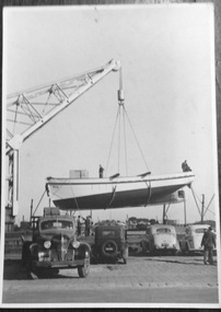
Photograph, Launch of the Penguin, 1940s
... The Legg family boat, Penguin, was launched on the Yarra..., was launched on the Yarra River. fishing boat-penguin legg family ...The Legg family boat, Penguin, was launched on the Yarra River.Matt black and white photo of the launch of the Penguin by craneNilfishing boat-penguin, legg family, fishing boats -
 Federation University Historical Collection
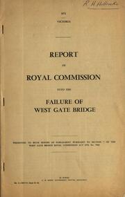
Book - Report, Report of Royal Commission into the Failure of West Gate Bridge, 1971, 1971
... of the Westgate Bridge over the Yarra River. .2) Document relatng... of the Westgate Bridge over the Yarra River. .2) Document relatng ....1) Foolscap soft brown covered report on the failure of the Westgate Bridge over the Yarra River. .2) Document relatng to the collapse of the Westgate Bridgewestgate bridge, bridges, royal commission, c.h. rixon, west gate, engineering -
 Tatura Irrigation & Wartime Camps Museum
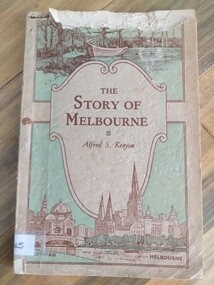
Book, The Story of Melbourne, 1934
... discovery scene and Yarra river, Flinders Street, Station and St... and Yarra river, Flinders Street, Station and St. Paul's Cathedral ...Cream, pale green cover. Brown lettering. Sketches of early discovery scene and Yarra river, Flinders Street, Station and St. Paul's Cathedralthe story of melbourne, kenyon af, stewart f, tatura, victorian history, sir gengoult-smith -
Port Melbourne Historical & Preservation Society
Photograph - Queen Street Bridge, Melbourne, 1990s
... , looking towards Queen Street Bridge with the Yarra River... with the Yarra River in foreground and the city skyline in background ...Colour photograph taken from under King Street Bridge, looking towards Queen Street Bridge with the Yarra River in foreground and the city skyline in backgroundbuilt environment, engineering - bridges -
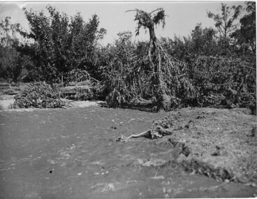 University of Melbourne, Burnley Campus Archives
Photograph - Black and white print, A.P. Winzenried, Flood Damage, 1934
... in the Burnley orchards by the 1934 flood of the Yarra River. One large... orchards by the 1934 flood of the Yarra River. One large tree ...Appears as an illustration in, "Green Grows Our Garden," A.P. Winzenried p 66. On p. 66 of the text there is further information about the effects of the flood.Black and white photograph. Destruction caused in the Burnley orchards by the 1934 flood of the Yarra River. One large tree is upside down with its roots in the air.On reverse, "1934."orchard, green grows our garden, a.p. winzenried, flood damage, fruit trees -
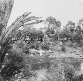 Eltham District Historical Society Inc
Album - Photograph, J.A. McDonald, Eltham-Templestowe Road, c. 1957
... Site for bridge over Yarra River looking from Eltham bank.... melbourne Site for bridge over Yarra River looking from Eltham bank ...Site for bridge over Yarra River looking from Eltham bank.Record of various Shire of Eltham infrastructure works undertaken during the period of 1952-1962 involving bridge and road reconstruction projects, sometimes with Eltham Shire Council Project Reference numbers quoted. It was during this period that a number of significant improvements were made to roads and new bridges constructed within the shire that remain in place as of present day (2022). In many situations, the photos provide a tangible visible record of infrastructure that existed throughout the early days of the Shire. The album was put together by or under the direction of the Shire Engineer, J.A. McDonald.infrastructure, road construction, shire of eltham, bridge construction, bridge street bridge, 1957, fitzsimons lane bridge, eltham-templestowe road -
 Kew Historical Society Inc
Photograph, Floods in North Kew, 1934
... . This was compounded by the area being bounded on three sides by rivers (Yarra... by the area being bounded on three sides by rivers (Yarra River ...Living with natural processes was frequently a challenge to early European settlers and later residents of what was in the 1850s administered by the Borondara Road Board. This was compounded by the area being bounded on three sides by rivers (Yarra River, Koonung Creek and Gardiner's Creek). In 1849, the historian James Bonwick recorded that "our district [Kew] suffered considerably. Mr Wade speaks of 80 acres, out of 100 acres of his cultivated paddock, covered by water." Newspapers continued to describe major flooding in Kew in 1863, 1869, 1878, 1880, 1889, 1891, 1916 and 1934. While the construction of the Upper Yarra dam in 1957 reduced the levels of flowing downstream, local and riverine floods continue.The Kew Historical Society's pictures and map collections testify to the impact of flooding in the district. They have historical importance in documenting the extent of flooding in the district and its affects on homes, services and recreation. Numerous photographs record flooding throughout the Twentieth Century.Floods in North Kew, 1934. Vicinity of Willsmere Park.floods (kew) -
 Kew Historical Society Inc
Photograph - Studley Park, 1937
... Those sections of Studley Park closest to the River Yarra... Those sections of Studley Park closest to the River Yarra were ...Those sections of Studley Park closest to the River Yarra were set aside as parkland in the 1850s. After initial discussions about whether it was a suitable site for a Government House, much of the land was instead gazetted in the 1860s as the location for a new lunatic asylum, to expand overcrowded mental health facilities at the Yarra Bend Asylum on the other side of the river at Fairfield. Those sections of Studley Park bounded by the Yarra River, Studley Park Road, Princess Street and Fellows Street were subdivided and sold at the Crown Land Sales in 1851. Much of this urban area remained open farmland until the twentieth century, apart from mansions, largely located along the main roads.Original, black and white positive print of what is said to represent Studley Park in 1937. If the attribution and date is literally to be understood, then it would appear that the photograph may have been taken from the Kew side of the river looking across to open farmland in the Yarra Bend Park. If the designation of Studley Park is to be understood more loosely, then it might be a view of what is now East Kew, taken from a section of Kilby Road. Inscribed verso: "Studley Park 1937" studley park -- kew (vic.) -
 Ballarat Heritage Services
Photograph, Views of the Westgate Bridge, 29/11/2022
... The Westgate Bridge spans the Yarra River giving access... Office goldfields The Westgate Bridge spans the Yarra River ...The Westgate Bridge spans the Yarra River giving access to Melbourne from the West. westgate bridge, melbourne, road, bridge -
Port Melbourne Historical & Preservation Society
Plan - Proposed improvements to Hobsons Bay, Melbourne Harbor Trust, The Melbourne Harbor Trust Commissioners - General p`lan shewing proposed harbor improvements 1915, 1915
... into the bay near the river and on the north side of the Yarra River.... the Yarra. The proposals include piers into the bay near the river ...MHT plan of proposed improvements to Hobson's Bay and areas surrounding and bordering the Yarra. The proposals include piers into the bay near the river and on the north side of the Yarra River.melbourne harbor trust - port of melbourne authority, hobson's bay, town planning - proposals shelved -
 Nillumbik Shire Council
Painting: Guy STUART (b.1942 ACT), Guy Stuart, Tunnel by the Yarra, 2004
... An abstract painting of the Yarra River from Pound Bend... of the Yarra River from Pound Bend in Warrandyte. The painting is quite ...An abstract painting of the Yarra River from Pound Bend in Warrandyte. The painting is quite expressive, linear and gestural in style. Muted, neutral tones of greens, browns and reds. -
 Kew Historical Society Inc
Photograph, Railway Viaduct, c.1900
... Railway viaduct, Yarra River, linking Kew and Fairfield... Mills, Alphington. Railway viaduct, Yarra River, linking Kew ...Railway viaduct, Yarra River, linking Kew and Fairfield. Built by John Monash for the Outer Circle Railway. In 1930 converted into the Chandler Highway Bridge for vehicular traffic. Annotations on reverse: "KH-71. Outer Circle Railway Bridge (over Yarra) looking from Kew side to site of Paper Mills, Alphington.outer circle railway, railway viaduct (kew), john monash, chandler highway bridge