Showing 4080 items
matching road plans
-
![Document collection, Watsonia development [Lambourn and Devonshire Roads], 2019_](/media/collectors/4f729f5697f83e03086015b8/items/5d82cea121ea6712b80a7cdd/item-media/5d8579dd21ea67168c696120/item-fit-380x285.jpg) Greensborough Historical Society
Greensborough Historical SocietyDocument collection, Watsonia development [Lambourn and Devonshire Roads], 2019_
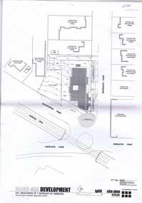
In 2003, a proposal for a 5 storey building on the corner of Lambourn and Devonshire Roads Watsonia for an apartment complex, medical centre, shops and cafe was approved by VCAT, despite strong opposition by local residents. The proposal did not proceed. In 2019 a proposal for a 2 storey medical centre, cafe and residence was approved for the site and construction commenced. Collection of documents comprising history of development proposals by Rosie Bray, concept illustrations, archtect's plans, photograph and copy of newspaper clipping.watsonia, lambourn road watsonia, devonshire road watsonia -
 Greensborough Historical Society
Document, Statement of evidence: VCAT Application P2461/2003, prep. by Marco Negri, Contour Consultants Aust Pty Ltd, 2004_03
Lawyers for the City of Banyule commissioned a report on the town planning implications of a proposal to construct a multi-level building on land at the corner of Lambourn and Devonshire Roads Watsonia, relating to the Council's refusal of a permit and the subsequent hearing by VCAT22 p., black & white with col. plans.watsonia, lambourn road watsonia, devonshire road watsonia -
 Greensborough Historical Society
Plan, brucehenderson architects, Plans for proposed development at Devonshire and Lambourne Roads Watsonia 2004, 2004_01
... Greensborough Historical Society 34A Glenauburn Road Lower ...Amended plans for a mixed use development corner Devonshire Road and Lambourn Road Watsonia in 2004.23 p., black & white and colour plans with covering letterwatsonia, lambourn road watsonia, devonshire road watsonia -
 Greensborough Historical Society
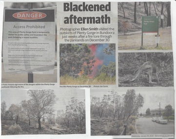
Newspaper Clipping, Diamond Valley Leader et al, Scorched Earth: attention turns to recovery plan after devastating Plenty Gorge fire, 29/01/2020
An eerie, blackened landscape remains after a bushfire ripped through more than 40 ha of the Plenty Gorge parklands.News article 2 pages, black text and colour images.plenty gorge park, bushfire -
 Greensborough Historical Society
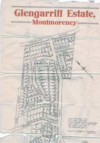
Map, Glengarriff Estate Montmorency, 1938c
Estate Agent's plan of Glengarriff Estate, Montmorency, covering LPs 11334 and 11451. Bordered by Sherbourne Avenue, Calrossie Avenue, Montmorency Station and Price AvenueColour photocopy of subdivision map, on two A3 sheets glengarriff estate montmorency, sherbourne avenue montmorency, calrossie avenue montmorency, price avenue montmorency, montmorency station -
 Greensborough Historical Society
Magazine, Banyule Banner Jan-Feb 2020, 2020_01
The Banyule Banner is published bi-monthly by Banyule City Council to advertise upcoming events in the City of Banyule and to report on past events. This edition covers future plans for Banyule, including environmental issues and developments with the North East Link project. A record of events within the City of Banyule.20 pages (approx.), colour illustrations. 3 copies.banyule banner, north east link, banyule council -
 Greensborough Historical Society
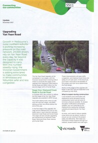
Pamphlet, Upgrading Yan Yean Road, 2017_11
... . photographs and plan. Upgrading Yan Yean Road Pamphlet Vicroads ...VicRoads let a contract for the upgrade of Yan Yean Road between Diamond Creek Road and Kurrak Road in October 20174p. text and col. photographs and plan.yan yean road -
 Greensborough Historical Society
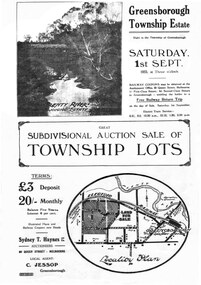
Plan - Digital Image, Greensborough Township Estate, 01/09/1923
Sub-division into 129 lots of land belonging to the Scotland Family, bounded by William Street, Eliza Street, James (Jessop) Street and south of Lorimer Street. Auction 1 September 1923Digital copy of plan. Has been digitally corrected from damaged original.subdivision plans, greensborough township estate, scotland family -
 Greensborough Historical Society
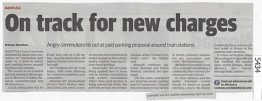
Newspaper Clipping, Diamond Valley Leader, On track for new charges, 18/04/2018
Banyule Council has been slammed for using train commuters as 'convenient cash cows' as it plans to install paid parking meters around bustling train stations at Macleod, Ivanhoe, Rosanna, Greensborough and MontmorencyNews article 1 page, black text.train station parking, parking meters, greensborough statiion, montmorency station, macleod station, banyule city council -
 Greensborough Historical Society
Map, Municipality of Heidelberg Plan No. 480, 17/10/1948
Map shows streets, buildings, river and major drainage easements in area covered by West boundary Sellars Street, North boundary Yando Street & South boundary Grimshaw Street. Adjoins Map No. 481 to East. Black & white map, features marked in green, gradients in red. Scale: 160 feet to 1 inchgreensborough -
 Greensborough Historical Society
Map, Municipality of Heidelberg Plan No. 481, 23/9/1949
Central area of Greensborough, South boundary Grimshaw Street, showing river and buildings in green and gradients in red. Adjoins Map No. 480 to West.Black & white map with features in red and green. Scale: 160 feet to 1 inch.greensborough, grimshaw street greensborough -
 Greensborough Historical Society
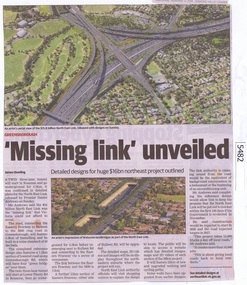
Newspaper Clipping, Diamond Valley Leader, 'Missing Link' unveiled, 12/09/2018
A twin three lane tunnel will start in Rosanna and go underground for 5.3km, it was confirmed in detailed plans for the North East Link released by Premier Daniel Andrews on Sunday.News article 1 page, black text and colour image .north east link, daniel andrews, rosanna -
 Greensborough Historical Society
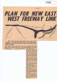
Newspaper Clipping, Diamond Valley News, Plan for new East-West freeway link, 1967c
Early plans for the Greensborough by-pass and western ring road.Newspaper clipping, black and white text and image.greensborough bypass, western ring road -
 Greensborough Historical Society
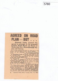
Newspaper Clipping, Diamond Valley News, Agreed on road plan ... but, 14/11/1967
... Agreed on road plan ... but.... Agreed on road plan ... but Newspaper Clipping Diamond Valley ...Diamond Valley Council agreed in principle to the proposed Greensborough By-pass and freeway, with further discussion needed on some points.Newspaper clipping, black and white text.greensborough bypass, shire of diamond valley -
 Greensborough Historical Society
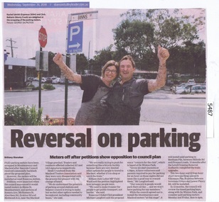
Newspaper Clipping, Diamond Valley Leader, Reversal on parking, 26/09/2018
Paid parking meters have been scrapped in Montmorency and Macleod after Banyule Council received community backlash about the proposed plan.News article 1 page, black text and colour image .paid parking meters, montmorency, macleod, banyule city council -
 Greensborough Historical Society
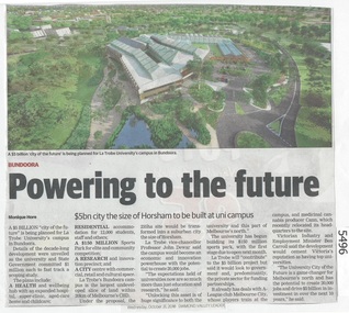
Newspaper Clipping, Diamond Valley Leader, Powering to the future: La Trobe University, 31/10/2018
A $5 billion city of the future is being planned for La Trobe University's campus in BundooraNews article 1 page, black text and colour image .bundoora, la trobe university -
![Advertising Leaflet, Grace Park Electric Station Estate, Watsonia [2], 21/06/1924](/media/collectors/4f729f5697f83e03086015b8/items/5dcfb86d21ea671434eca90c/item-media/5dcfb88e21ea671434ecd037/item-fit-380x285.jpg) Greensborough Historical Society
Greensborough Historical SocietyAdvertising Leaflet, Grace Park Electric Station Estate, Watsonia [2], 21/06/1924
Digital copy of auction leaflet for sale of land known as Grace Park Electric Station Estate, Saturday 21/06/1924. Auctioneer Knight & Harwood in conjunction with C. Jessop. This leaflet features block plans and a railway line illustration showing the site of 'Grace Park Railway Station'.Digital copy of auction leaflet 1 page. Black and red text on white paper.watsonia, grace park -
 Greensborough Historical Society
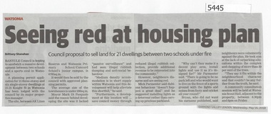
Newspaper Clipping, Diamond Valley Leader, Seeing Red at Housing Plan, 16/05/2018
Banyule Council is hoping to sandwich a massive development between two schools and a sports oval in Watsonia.News article 1 page, black text.watsonia, knight street watsonia, concord school, watsonia primary school, residential development, banyule city council -
 Greensborough Historical Society
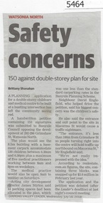
Newspaper Clipping, Diamond Valley Leader, Safety concerns, 18/07/2018
A planning application for a double storey childcare and medical centre to be built at the intersection of Grimshaw Street and Macorna Street has left the community seeing red.News article 1 page, black text.childcare centre, watsonia north, grimshaw street watsonia, macorna street watsonia -
 Greensborough Historical Society
Newspaper Clipping, Diamond Valley Leader, Proposal rejected, 25/07/2018
Banyule Council has refused a planning permit application that would have seen a double-storey childcare and medical centre built at a bustling intersection in Grimshaw Street Watsonia.News article 1 page, black text.watsonia, childcare centre, grimshaw street watsonia, macorna street watsonia, banyule city council -
![Plan, Surveyor's Street Plan of Melbourne 1837 [copy], 1837_](/media/collectors/4f729f5697f83e03086015b8/items/534ccbc12162ef06c8d2cbf7/item-media/58afbfe2d0ce1616fcdf244b/item-fit-380x285.jpg) Greensborough Historical Society
Greensborough Historical SocietyPlan, Surveyor's Street Plan of Melbourne 1837 [copy], 1837_
Copy of Surveyor's Street Plan of Melbourne 1837. Donated by Patsy Coverdale and accompanied by brief details of her family connection to the map. Copies of plan available for sale from Greensborough Historical Society.Map of early Melbourne with connections to a current resident.Copy of plan, mounted on timber and framed.melbourne street plan, coverdaye, umpleby -
 Greensborough Historical Society
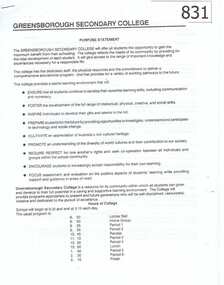
Document, Greensborough Secondary College Documents 1990. Gr8750, 1990_
This collection of documents includes the Greensborough Secondary College Purpose Statement, Counter Disaster Plan and draft Prospectus Statements.These documents are examples of the administration of the 'new' Greensborough Secondary College, formed after the amalgamation of Watsonia High and Watsonia Technical schools.Photocopied and stapled documents. greensborough secondary college, greensborough college -
 Greensborough Historical Society
Newspaper Clipping, Diamond Valley News, Apollo Parkways School may start with 220 pupils, 24/10/1978
In 1978 Apollo Parkways Primary School [AP5184] was in the planning stages. In this article the Principal is named and plans for permanent buildings are discussed. The school opened in 1979.Information about the development of a new school in the Greensborough area.Photocopy of newspaper article,Date written on side.apollo parkways primary school, frank miller -
 Greensborough Historical Society
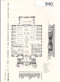
Plan, Watsonia High School Library: floor plan 1971, 1971_
In the early 1970s "Commonwealth Libraries" were funded in secondary schools. This is the proposed plan for the Watsonia High School Library.An example of school library plans from the 1970s.3 copies of a one-page floor plan and front elevation of building.Written on front "Watsonia"watsonia high school, commonwealth libraries -
 Greensborough Historical Society
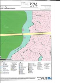
Map, Pioneer children's graves precinct, 1848-1860
Map showing the location and surrounds of Pioneer Children's Cemetery on the Plenty River in Greensborough. Children from pioneer families are buried here.Official government planning map for the Pioneer Children's Graves Precinct.Printed coloured copy of map of Plenty River areapioneer childrens cemetery, greensborough, partington, whatmough -
 Glenelg Shire Council Cultural Collection
Administrative record - Plans, n.d
Black and white photocopy of old plan of subdivision, same as 8398, 8399, smaller scale, numerous notations, added by Vanda Savill. -
Glenelg Shire Council Cultural Collection
Photograph - Photograph - contact sheet of 12 local Portland prints, 1970s
Sheet of 12 contact prints of rephotographed photographs: (a) Pioneers of Portland (b) The Thistle - story of (c) St. Stephens C of E (d) Portland from Observatory Hill (e) Julia Street (f) Gaol - Plans (g) Annie Clark's ladies school (h) View from Cape Bridgewater (i) Maretimo (j) Cape Bridgewater (k) Julia Street (l) Tasmanian InnFront: 3 x 5 each print Back: 3.5 x 5.5 -
 Glenelg Shire Council Cultural Collection
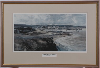
Print, Albert Henry Fullwood, Portland Victoria, c. 1886
Scene of Portland Harbour. View includes people walking on beaches, jetties, morred boats (some with sails, some without). Upper centre of image shows a town, with a church to the right. To the left centre is a planned garden with people promenading. In foreground is empty land with a few seagulls. A train track enters the image on bottom centre. Print is predominantly in shades of blue, grey and brown. Framed, no glass.Front: A. H. Fullwood Back: (no insciptions)print, portland harbour -
 Greensborough Historical Society
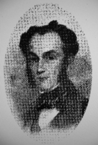
Photograph - Digital image, Portrait of Edward Green, 1850c
Portrait of Edward Green. In the 1840s, Edward B. Green ran the mail service between Melbourne and Sydney and owned a parcel of land on the Plenty River. He engaged a surveyor to draw up plans and lay out a township on the slopes overlooking the river, and to mark out small farm holdings on the flats. This small township named after him is now Greensborough.Digital copy of portrait.edward bernard green, greensborough history -
 Greensborough Historical Society
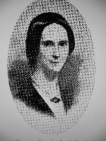
Photograph - Digital image, Mrs Edward Green, 1850c
Portrait of Mrs Edward Green. In the 1840s, Edward B. Green ran the mail service between Melbourne and Sydney and owned a parcel of land on the Plenty River. He engaged a surveyor to draw up plans and lay out a township on the slopes overlooking the river, and to mark out small farm holdings on the flats. This small township named after him is now Greensborough.Digital copy of portraitedward bernard green