Showing 778 items
matching stone house
-
 Eltham District Historical Society Inc
Photograph - Digital Photograph, Alan King, Blue Lake, Plenty Gorge Park, 2008
A quarry was transformed into the Blue Lake. Published: Nillumbik Now and Then / Marguerite Marshall 2008; photographs Alan King with Marguerite Marshall.; p179 The dramatic steep-sided Plenty Gorge lies along the divide of two geological areas, and separates the Nillumbik Shire and the City of Whittlesea. On the Nillumbik side are undulating hills and sedimentary rock, and in Whittlesea, lies a basalt plain formed by volcanic action up to two million years ago. This provides the Plenty Gorge Park with diverse vegetation and habitats, making it one of Greater Melbourne’s most important refuges for threatened and significant species. The park, established in 1986, consists of around 1350 hectares, and extends 11 kilometres along the Plenty River, from Greensborough to Mernda. It provides a wildlife corridor for around 500 native plant and 280 animal species. The area’s plentiful food and water attracted the Wurundjeri Aboriginal people and then European settlers. By 1837 squatters had claimed large runs of land for their sheep and cattle. The Plenty Valley was among the first in the Port Phillip District to be settled - mainly in the less heavily timbered west - and was proclaimed a settled district in 1841.But by the late 1880s, the settlers’ extensive land clearing for animal grazing, then agriculture, depleted the Wurundjeri’s traditional food sources, which helped to drive them away. Many Wurundjeri artefacts remain (now government protected), and so far 57 sites have been identified in the park, including scarred trees, burial areas and stone artefacts. Pioneer life could be very hard because of isolation, flooding, bushfires and bushrangers. Following the Black Thursday bushfires of 1851, basalt was quarried to build more fire-resistant homes. Gold discoveries in the early 1850s swelled the population, particularly around Smugglers Gully; but food production made more of an impact. In the late 1850s wheat production supplanted grazing. In the 1860s the government made small holdings available to poorer settlers. These had the greatest effect on the district, particularly in Doreen and Yarrambat, where orchards were established from the 1880s to 1914. Links with a prominent early family are the remains of Stuchbery Farm, by the river’s edge bounded by Smugglers Gully to the north and La Trobe Road, Yarrambat, to the east. The Stuchberys moved to the valley in 1890, and the family still lives in the area. In 1890, Alfred and Ada first lived in a tent where four children were born, then Alfred built the house and outbuildings around 1896. They planted an orchard, then a market garden, and developed a dairy. The family belonged to the local Methodist and tennis communities. Their grandson Walter, opened the Flying Scotsman Model Railway Museum in Yarrambat, which his widow, Vi, continues to run. Wal was also the Yarrambat CFA Captain for 22 years until 1987. Walter sold 24 hectares in 1976 for development - now Vista Court - and in 1990, the remaining 22.6 hectares for the park. Remaining are an early stone dairy and remnants of a stone barn, a pig sty and a well. Until it was destroyed by fire in 2003, a slab hut stood on the Happy Hollow Farm site, at the southern end of the park. The hut is thought to have been built in the Depression around 1893. This was a rare and late example of a slab hut with a domestic orchard close to Melbourne. Emmet Watmough and his family first occupied the hut, followed by a succession of families, until the Bell family bought it around 1948. There they led a subsistence lifestyle for 50 years, despite encroaching Melbourne suburbia. The Yellow Gum Recreation Area includes the Blue Lake, coloured turquoise at certain times of the year. Following the 1957 bushfires, this area was quarried by Reid Quarries Pty Ltd for Melbourne’s first skyscrapers, then by Boral Australia. However in the early 1970s water began seeping into the quarry forming the Blue Lake and the quarry was closed. The State Government bought the site in 1997 and opened it as a park in 1999.This collection of almost 130 photos about places and people within the Shire of Nillumbik, an urban and rural municipality in Melbourne's north, contributes to an understanding of the history of the Shire. Published in 2008 immediately prior to the Black Saturday bushfires of February 7, 2009, it documents sites that were impacted, and in some cases destroyed by the fires. It includes photographs taken especially for the publication, creating a unique time capsule representing the Shire in the early 21st century. It remains the most recent comprehenesive publication devoted to the Shire's history connecting local residents to the past. nillumbik now and then (marshall-king) collection, blue lake, plenty gorge park -
 Eltham District Historical Society Inc
Photograph - Digital Photograph, Marguerite Marshall, Stuchbery Farm dairy, 14 March 2008
Stuchbery Farm was situated on the Plenty River bounded by Smugglers Gully to the north and La trobe Road, Yarrambat, to the east. Alan and Ada Stutchbery moved to the valley in 1890, first living in a tent where four children were born. Alfred built a home and outbuildings around 1896. They planted an orchard, then a market garden and developed a dairy. Published: Nillumbik Now and Then / Marguerite Marshall 2008; photographs Alan King with Marguerite Marshall.; p179 The dramatic steep-sided Plenty Gorge lies along the divide of two geological areas, and separates the Nillumbik Shire and the City of Whittlesea. On the Nillumbik side are undulating hills and sedimentary rock, and in Whittlesea, lies a basalt plain formed by volcanic action up to two million years ago. This provides the Plenty Gorge Park with diverse vegetation and habitats, making it one of Greater Melbourne’s most important refuges for threatened and significant species. The park, established in 1986, consists of around 1350 hectares, and extends 11 kilometres along the Plenty River, from Greensborough to Mernda. It provides a wildlife corridor for around 500 native plant and 280 animal species. The area’s plentiful food and water attracted the Wurundjeri Aboriginal people and then European settlers. By 1837 squatters had claimed large runs of land for their sheep and cattle. The Plenty Valley was among the first in the Port Phillip District to be settled - mainly in the less heavily timbered west - and was proclaimed a settled district in 1841. But by the late 1880s, the settlers’ extensive land clearing for animal grazing, then agriculture, depleted the Wurundjeri’s traditional food sources, which helped to drive them away. Many Wurundjeri artefacts remain (now government protected), and so far 57 sites have been identified in the park, including scarred trees, burial areas and stone artefacts. Pioneer life could be very hard because of isolation, flooding, bushfires and bushrangers. Following the Black Thursday bushfires of 1851, basalt was quarried to build more fire-resistant homes. Gold discoveries in the early 1850s swelled the population, particularly around Smugglers Gully; but food production made more of an impact. In the late 1850s wheat production supplanted grazing. In the 1860s the government made small holdings available to poorer settlers. These had the greatest effect on the district, particularly in Doreen and Yarrambat, where orchards were established from the 1880s to 1914. Links with a prominent early family are the remains of Stuchbery Farm, by the river’s edge bounded by Smugglers Gully to the north and La Trobe Road, Yarrambat, to the east. The Stuchberys moved to the valley in 1890, and the family still lives in the area. In 1890, Alfred and Ada first lived in a tent where four children were born, then Alfred built the house and outbuildings around 1896. They planted an orchard, then a market garden, and developed a dairy. The family belonged to the local Methodist and tennis communities. Their grandson Walter, opened the Flying Scotsman Model Railway Museum in Yarrambat, which his widow, Vi, continues to run. Wal was also the Yarrambat CFA Captain for 22 years until 1987. Walter sold 24 hectares in 1976 for development - now Vista Court - and in 1990, the remaining 22.6 hectares for the park. Remaining are an early stone dairy and remnants of a stone barn, a pig sty and a well. Until it was destroyed by fire in 2003, a slab hut stood on the Happy Hollow Farm site, at the southern end of the park. The hut is thought to have been built in the Depression around 1893. This was a rare and late example of a slab hut with a domestic orchard close to Melbourne. Emmet Watmough and his family first occupied the hut, followed by a succession of families, until the Bell family bought it around 1948. There they led a subsistence lifestyle for 50 years, despite encroaching Melbourne suburbia. The Yellow Gum Recreation Area includes the Blue Lake, coloured turquoise at certain times of the year. Following the 1957 bushfires, this area was quarried by Reid Quarries Pty Ltd for Melbourne’s first skyscrapers, then by Boral Australia. However in the early 1970s water began seeping into the quarry forming the Blue Lake and the quarry was closed. The State Government bought the site in 1997 and opened it as a park in 1999.This collection of almost 130 photos about places and people within the Shire of Nillumbik, an urban and rural municipality in Melbourne's north, contributes to an understanding of the history of the Shire. Published in 2008 immediately prior to the Black Saturday bushfires of February 7, 2009, it documents sites that were impacted, and in some cases destroyed by the fires. It includes photographs taken especially for the publication, creating a unique time capsule representing the Shire in the early 21st century. It remains the most recent comprehenesive publication devoted to the Shire's history connecting local residents to the past. nillumbik now and then (marshall-king) collection, ada stuchbery, alan stuchbery, dairy, stuchbery farm, farm buildings, yarrambat, plenty gorge park -
 Eltham District Historical Society Inc
Photograph - Digital Photograph, Alan King, Sign: Clara Southern, Heidelberg School Artists Trail, Main Road, Research, 2008
Warrandyte artist, Clara Southern, features on the Artists Trail. Published: Nillumbik Now and Then / Marguerite Marshall 2008; photographs Alan King with Marguerite Marshall.; p189 Since early in the 20th century this district has attracted artists and other creative people. So much so, that Eltham has been compared to the Left Bank in Paris, New York’s Greenwich Village and London’s Bloomsbury. That is until the 1970s when Eltham rapidly expanded into a suburb. However many artists still flourish not only in Montsalvat, Dunmoochin and the Bend of Islands but elsewhere in Nillumbik. Some artists who have worked or lived in Nillumbik are well-known nationally and internationally. Artists are attracted to the hilly district’s subtle colours, unique light and the Yarra River and Diamond Creek. The railway’s extension to Eltham in 1902 brought artists to paint for the day or to camp. Then many settled in Eltham, perhaps also because the poor quality land, far from the city, was cheap. Following World War Two they found they could build houses and studios cheaply by making their own mud-bricks. The flexible material, with its warm tones blending into the bush, also satisfied their aesthetic sensibilities. As early as 1900, Will Longstaff, known for his painting The Ghosts of Menin Gate at the National War Memorial in Canberra, lived at Stanhope in Peter Street, Eltham, later to become the home of intellectuals Clem and Nina Christensen. Members of Australia’s first significant art movement, the Heidelberg School of Artists, painted in Eltham, Warrandyte and Diamond Creek. Walter Withers lived at the corner of Bolton and Brougham Street, Eltham and taught Sir Hans Heysen, who for a short while stayed with the Withers family. In Warrandyte were Clara Southern, whom Frederick McCubbin taught at the National Gallery School and Penleigh Boyd, who is represented in all Australian state galleries and the National Collection in Canberra. May Vale, daughter of politician William, lived in Diamond Creek. With Jane Price they feature on the Heidelberg School Artists Trail, part of which runs through Nillumbik. The trail includes signs each displaying a reproduction of a painting by an artist and located near where the artist lived or painted. In Nillumbik the trail includes parts of Warrandyte, Eltham in the Alistair Knox Park, Main Road shopping precinct and Wingrove Park, the Research walking track on Main Road and the Diamond Creek Reserve. In 1916 artist William ‘Jock’ Frater lived at the corner of Arthur and Bible Streets, Eltham. Before then, Frater, with other artists including Percy Leason (who moved to Eltham in the mid 1920s) painted in Eltham on weekends. They camped near Bible and Pitt Streets and along the Diamond Creek where the Eltham Retirement Centre now stands.4 In 1921, painter Peter Newbury (father to painter David Newbury, who was born in Eltham) moved to Cromwell Street, Eltham. Max Meldrum, the first Australian painter to formulate a consistent theory of art largely based on tone,5 taught local artists Alan Martin, Clarice Beckett, Peter Glass and Justus Jörgensen. Meldrum visited Eltham then rented a house there for 18 months opposite Wingrove Park. In 1934, artist and architect Justus Jörgensen and his doctor wife Lil and friends built Montsalvat, the artists’ colony. Montsalvat has played an important part in attracting artists to Eltham and its mud-brick, pisé, stone and recycled building materials has had a major influence on Eltham’s built environment. Jörgensen’s students who also helped him build Monstalvat included Arthur Munday, Lesley Sinclair, Helen Lempriere, Joe Hannan, Helen, Sonia and jeweller/sculptor, Matcham Skipper. Among artists who visited Montsalvat were Clifton Pugh and Angry Penguins’ artists Albert Tucker and Arthur Boyd. Some who painted after World War Two were Alan Martin of Eltham and Warrandyte artists Frank Crozier and Harry De Hartog6, one of Melbourne’s first painters influenced by Cubism.This collection of almost 130 photos about places and people within the Shire of Nillumbik, an urban and rural municipality in Melbourne's north, contributes to an understanding of the history of the Shire. Published in 2008 immediately prior to the Black Saturday bushfires of February 7, 2009, it documents sites that were impacted, and in some cases destroyed by the fires. It includes photographs taken especially for the publication, creating a unique time capsule representing the Shire in the early 21st century. It remains the most recent comprehenesive publication devoted to the Shire's history connecting local residents to the past. nillumbik now and then (marshall-king) collection, clara southern, main road, research (vic), heidelberg school artists trail -
 Port Fairy Historical Society Museum and Archives
Photograph, Mason, John
Captain John Mason came from Stirling in Scotland, arriving at Port Fairy in 1844. One year after James Atkinson obtained his Special Survey of the area. Thus his life covers all the history of Port Fairy when it was known as Belfast. He married Jane Murray in Portland in 1846 and they had 5 children, Jane died in 1855 and ten years later he married Ann Brown widow of Abijah Brown. They had no children and she died in 1887. In due course he became known as Captain Mason, he was not a sea captain, but captain of the Belfast Volunteers, a Rifle Corps formed in 1859 as a consequence of the Crimean War, and later reconstituted as the Belfast Volunteer Corps. For 40 years he displayed a remarkable versatility in his various occupations. Starting as an Innkeeper - he took over the Stag Inn from Captain Saunders in 1852, for 3 years. He then became a carpenter, stonemason, architect, estate agent honorary technical advisor to the Borough and treasurer to the Shire, and Savings Bank Secretary. They thought so well of John mason in Belfast that they elected him to the first Roads Board in 1853 and to the first Municipal Council in 1856. He was Chairman four times and with Councillors David Talbot and Joseph Whitehead designed the Council's Common Seal and the Motto "Commune Bonum".He was the first Mayor of the Borough in 1863 for a period of 7 weeks. He was responsible for the design, supervision or construction of many of the buildings in the town; most still standing today. He built the Rosebrook Bridge in 1855 and the first official Post Office ( a timber structure in Bank Street) in 1857, replacing it with a stone office in 1865. he built the Court house in 1859 and completed the breakwater between Rabbit Island and Griffith Island started by James Atkinson and John Griffith in 1849, also the first bridge over the Moyne river which connected with Battery Lane and the Bay. Among the many buildings associated with John Mason are Gobles Mill, Tynemouth Villa, 10-12 Princes Street, the Mechanics Institute, the Commercial Hotel, Yambuk and Mickey Bourke's Pub in Koroit. However, he did not build "Riverdale" in Gipps Street as is thought. He had a store and workshop on this site but sold the property in 1872 before the house was built. After an almost uninterrupted term as Councillor starting with the Municipality in 1856, John resigned from the Council in 1873. He well deserved the illuminated address they gave to him and the toast that they drank in the Bank Hotel champagne. Within the year he was working for the Borough as its engineer., surveyor, general supervisor and advisor of public works, simply as the man to whom all difficult problems were referred and at very little expense. John Mason was a great worker for his town and devoted himself unsparingly to the community. That his work was appreciated was shown by the way in which people rallied to his aid when, in the end, he found himself in financial difficulties and his reputation was challenge; arrested for embezzling from the Savings Bank of which he was the actuary in 1882. The money was repaid and the charges found not proven at his trial. He was an early member of the Loyal Prince Albert Lodge, and a founding member of the smaller Loyal Belfast Lodge in 1863. He was also a member of the Horticultural Society. Captain John Mason Died on the 14th of October 1891 (see also 62-04-046 photo)Sepia photograph on heavy cardStevenson & McNicoll photo. 108 Elizabeth Street Melbourne copies can be obtained at anytimedefence, captain, mason, carpenter, councillor, mayor -
 Bacchus Marsh & District Historical Society
Photograph, Simpsons Butchery Main Street Bacchus Marsh 1883
John Simpson arrived in Bacchus Marsh around 1848. In 1850 he established a butchery business. He continued to operate this business in Main Street Bacchus Marsh until his death in 1890. His son John Simpson and one of his brothers, Edward took over the business and operated it until 1923. John Simpson the younger died in 1940 having lived all but a few months of his 92 years in Main Street Bacchus Marsh. Edward L. Simpson died in Corowa, NSW in 1937. The younger John Simpson's recollections of Bacchus Marsh in the 1850s to 1870s were published in the Bacchus Marsh Express on the 25 June 1932.Small sepia unframed photograph on card with gold border framing photograph. Housed in the album, 'Photographs of Bacchus Marsh and District in 1883 by Stevenson and McNicoll'. The image shows a butchery shop in Main Street Bacchus Marsh in 1883. The front of the building is shown. It is a solid brick or stone structure with a shingled roof and verandah. Hanging under the verandah are numerous carcasses and portions of meat. Two men are standing close together in front of the shop. One is wearing a butcher's apron. Another man to the left sits upon a horse. In the doorway behind the men stands a woman. On the front: Stevenson & McNicoll. Photo. 108 Elizabeth St. Melbourne. COPIES CAN BE OBTAINED AT ANY TIME. On the back: LIGHT & TRUTH inscribed on a banner surmounted by a representation of the rising sun. Copies of this Portrait can be had at any time by sending the Name and Post Office Money Order or Stamps for the amount of order to STEVENSON & McNICOLL LATE BENSON & STEVENSON, Photographers. 108 Elizabeth Street, MELBOURNE. stevenson and mcnicoll 1883 photographs of bacchus marsh and district, butcher shops, butchers, john simpson butcher 1848-1940, john simpson butcher died 1890 -
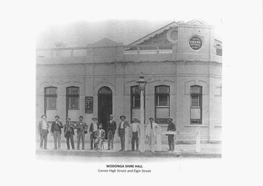 Wodonga & District Historical Society Inc
Photograph - Wodonga Civic Buildings Over Time
Wodonga Shire was created in 1876 when the colonial government agreed to ratepayers' petitions to have their part of the local government district severed from the Yackandandah Shire to form a new municipality. After meeting for 14 years in rented remises, in the Prince of Wales Hall, Wodonga Council built its first Shire Hall on the corner of High and Elgin Streets in 1890. The date on the façade of the building, 1876, represents the date of the formation of the Shire. In 1957 the second Shire Office was built in Woodland Grove by A.B. and M. A. Chick. These offices were considered more than adequate for future needs. The façade featured floor to ceiling windows and several different meeting rooms in addition to the council chamber, which featured an impressive “horse shoe” table. It also included a kitchen equipped with modern fittings and a President’s room. In the late 1960s the area between Hovell and Havelock Streets as far as Jack Hore Place was zoned for civic purposes. In 1969 plans for a civic centre providing a library, theatre and senior citizens’ rooms. It was opened on 22 April 1971. In 1973, the Council engaged Bruce Marshall to design new offices beside the Civic Centre. Jennings Industries were contracted to complete the offices. The Governor, Sir Henry Winneke, laid the foundation stone of the new offices on 10 March 1976. The Civic Centre was demolished in 2011 to make may for a new $10 million community and entertainment centre which opened in August 2012.These photos are significant because they depict the different buildings which have housed the centre of local government in Wodonga since its inception as an independent shire in 1876.A series of photographs depicting the different buildings used to house the Wodonga Council and Civic buildings over time.wodonga civic buildings, wodonga council, shire of wodonga, rural city of wodonga -
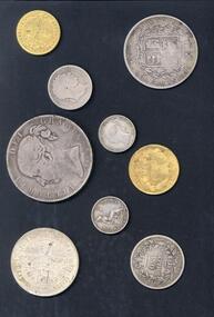 Vision Australia
Photograph - Image, 1868 Time Capsule at St Kilda Road, 1985
In 1868, with the laying of the foundation stone, a time capsule was placed containing four newspapers of the day (Saturday 25 January, 1868 - The Age, The Argus, The Sun and The Telegraph: St Kilda, Prahran and South Yarra Guardian), the first Annual report of the Victorian Asylum and School for the Blind (1867), 11 coins from the Victorian regency and an illustration of the proposed building at St Kilda Road. An undated note also describes a piece of parchment in the time capsule, which contained a list of names of committee members and relevant people involved in the construction of the building, such as Crouch & Wilson; however no image of this has been located. In 1991, this time capsule was opened as part of 125 year celebrations and the contents were put on display. The capsule was the size of a house brick and buried underneath the foundation stone. It was made of metal and had to be sawn open to reveal the contents. These images are of the items found inside the time capsule. Additionally there are low res images of these items plus some photographs taken on the day: Brian Howe, Minister for Health, holds the time capsule whilst Trent Willard and Janice Johns, current RVIB students, stand by during the raising ceremony; Miss Molly Miller, the oldest surviving student, and Mr Percy Raufer, great grand nephew of Mary-Ann Raufer who was pupil number 6 and enrolled in the school in January 29th, 1866 look at the items found in the time capsule. In 2005 a new time capsule was buried, including an electronic copy of the 1867 report and drawing of St Kilda Road from the 1868 time capsule.Photographs and scans of items found inside the time capsuleroyal victorian institute for the blind, brian howe, trent willard, janice johns, molly miller, percy raufer, time capsule -
Lakes Entrance Historical Society
Photograph - Housing, 2000 c
... inserts and stone pedestal with sundial. Houses Heritage Study ...Second photo of front garden, stone fence with wrought iron inserts and stone pedestal with sundial.Colour photograph of timber dwelling. Tiled gabled roof, decorative stone work on chimney, stone front fence with wrought iron inserts. House renovated sometime during 1990's, aluminium framed windows installed replacing original timber sash windows, at 7 Williams Road, Lakes Entrance Victoriahouses, heritage study -
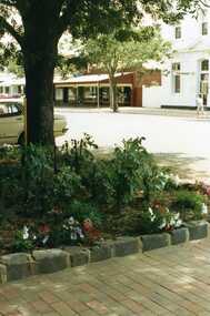 Charlton Golden Grains Museum Inc
Photograph, Pollard, Jenny, Garden bed in front of Tippett's shop, c.1989
High St Charlton 1989. Garden bed in front of Tippett's Haberdashery and Furniture Shop (later House & Home). Across the street is the Westpac Bank and Arundell's Shoe Shop. The photo was taken by Jenny Pollard for the Shire of Charlton 1989.Colour photograph of garden bed showing stone edging and brickpaving. Large tree and petunias growing in bed. Westpac Bank across the road.tippett, arundell, westpac, high street, charlton -
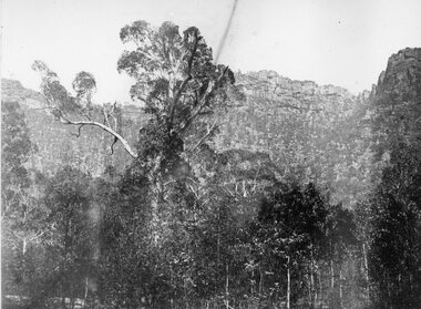 Stawell Historical Society Inc
Photograph, "Barney’s Castle" in the Grampians at Halls Gap 1866
Grampians Halls Gap (Barney’s Castle). Part of a collection of Photographs by Mr. O.G. Armstrong as commissioned by the Shire of Stawell for the Inter-colonial and Paris Exhibition in Melbourne in 1866. In 1880 a branch line from Stawell Railway Yards was built to Heatherly Quarry, to carry stone for part of Parliament House Melbourne, the GPO in Elizabeth St, the Harbour Trust buildings, additions to the Melbourne Town Hall, the Stawell Courthouse Patrick Street and the Stawell Catholic Church in Patrick St. The line was taken over by the Railways Department in June 1905 and was closed in March 1949. It has since been removed but remnants of the machinery and buildings are visible at the quarry site. stawell -
 Ballarat Heritage Services
Photograph - School, Australia outlined in stone at the site of the Former Dry Diggings State School, 2004, 05/08/2004
This school opened as a common school in 1871 and was originally called Dry Diggings and it replaced Dry Diggings School (No.725), which closed in 1869. The first head teacher was Henry Humffray. There were 40 students when the school opened. The timber schoolhouse had a shingle roof and pine floor. It had been moved from Dry Diggings School. There were 77 students at the school in 1873. A house was built for the teacher in 1874. It had 4 rooms, a veranda, and a shingle roof. The school became a state school at some stage between 1873 and 1878.Four colour photographs showing a carved Australia into rock in the former Dry Diggings Primary School playground.dry diggings, education, schools, dry diggings state school, australia, rock art, henry humffray -
City of Moorabbin Historical Society (Operating the Box Cottage Museum)
Newsletter - CMHS Moorabbin Mirror Issue 13 February 2018, CMHS Moorabbin Mirror Newsletter Issue 13 February 2018, 2018
This is Issue 13 of the Moorabbin Mirror produced by CMHS members Fran & Holger Bader , Geoffrey Paterson, February 2018 The Moorabbin Mirror reflects the history and heritage of the former City of Moorabbin — derived from Mooroobin, ‘a resting place’ in the Bunurrung spoken language. In 1994, the City of Moorabbin was integrated into the Cities of Bayside, Glen Eira, Kingston and Monash. Topics: Vale Mr Laurie Lewis; Street Names Files; KCC Tribute for Dr G Whitehead 20years ; Local heritage 'What House is that?'; Sands & McDougal 1860-1974 digitized by State Library Vic.;Alan Clarke donated in 2016 handwritten S&M copies of residents ; 1818 1st Australia Day Gvnr. Lachlan Macquarie;1858 Foundation Stone St Patrick's Cathedral laid by Bishop J.A. Goold; 1882 Assassination attempt on A/Bishop Goold in Brighton; 1948 UN Declaration of Human Rights; Census Victoria 2016 results; Plateways by Phil Rickard Light Rail HS;Flooding at BCM Dec./Jan. ; August Rietman Exhibition Report & Photos; This is Issue 13 of the Moorabbin Mirror, Newsletter of CMHS February 2018A4 x 3 paper folded to A5 x 6pp printed both sides with colour photographs. Moorabbin / Mirror / Newsletter City of Moorabbin Historical Society Inc. A0020543 (CMHS) / operating Box Cottage Museum (BCM) / ISSUE 13 FEBRUARY 2018moorabbin mirror, bader fran, bader holger, patterson geoffrey, lewis laurie;street name files; whitehead dr g.; sands and mcdougal; clark a; archbishop gool j.a.; st. patrick's cathedral melbourne; governor macquarie l.; plateways; rickard phil.; ohm 2017; reitman august, rietman stefanie; rietman william; lone digger memorials wwi; -
 Royal Australian and New Zealand College of Obstetricians & Gynaecologists (RANZCOG)
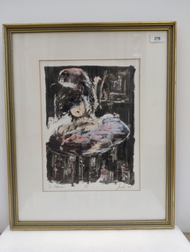
Print - Lithograph, Peter Jacobs (b. 1949), The Bathroom, 1988
It is likely this item was received from the estate of John 'Jack' Courier. Courier left a bequest to the College consisting of a significant number of artworks by himself and others, including Peter Jacobs.Stone coloured lithograph print of a figure in a bathtub. The head and shoulders of a figure are visible within a bathtub at the centre of the image. The top half of the face of the figure is obscured. There is a mirror visible in the background at the upper right of the image. Handwritten text below image reads " 'The Bathroom' 3/15 Jacobs 88". There is a large auction house sticker printed with the number '82' attached to upper right of reverse of the object. There are also two smaller auction house stickers attached to the upper section of the reverse of the object. Two D-ring fittings and a cord have been added to the reverse of the artwork for hanging. There is a sticker advertising the framer of the work at the bottom centre of reverse.The Bathroom' 3/15 Jacobs 88 -
 Glenelg Shire Council Cultural Collection
Painting, Travis Webber, Greenmount, c. 1955
CEMA Art Collection Previously located in History HouseThe painting depicts a large stone building with two smaller buildings in the foreground. Within the foreground is a small patch of dirt and grass with a side view of a small building to the right and a front and side view of a small stone building to the left. In the background is the large building which features two chimmneys. To the left of the building is a leafless tree and pale blue sky. The work has a gold and green frame with glass.Front: "GREENMOUNT" (brown, lower left) TRAVIS WEBBER (brown, lower right) 23 (white sticker attached to glass Back: (No inscriptions) -
 Bacchus Marsh & District Historical Society
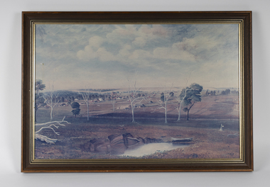
Painting, View of Bacchus Marsh from Stamford Hill circa 1880s
The date of the scene depicted in this painting has not been identified. The painting has no artist signature or date. The view depicted is from an area close to the present day Madden Drive in Bacchus Marsh. The angle of the view suggests the artists viewpoint may have been from a spot close to the intersection of Madden Drive and Muir Street looking east over the town. Several buildings constructed in the 1860s and 1870s can be seen in the painting. These include Saint Andrews Presbyterian Church (now Uniting Church), built 1865, Stone Villa in Bennett Street, the Bacchus Marsh Court House, the former National Bank and the Border Inn, all on Main Street, and in the distance Saint Bernard’s Catholic Church. Buildings such as Simon’s Garage erected in 1913, on the corner of Main Street and Grant Street are not shown. In the foreground running horizontally Grant Street can be seen. The view of Grant Street shows very few buildings. One house in the centre of the picture is Murdoch's Cottage. A brick house constructed in 1868 on the corner of Grant Street and Waddell Street. To the right of the picture along Grant Street no buildings are shown. The store built by John Jory in 1890 at 60-62 Grant Street which survives as a building in 2025 is not shown. Some allowance for artistic interpretation must be allowed but based on what the scene depicts it suggests a scene of Bacchus Marsh in the late 1870s or 1880s. Print reproduction of an oil painting. Framed. Undated. Unsigned. BMDHS Location: AR/B12/Beside (on floor)views bacchus marsh vic., paintings bacchus marsh vic., landscapes bacchus marsh vic. -
 Linton and District Historical Society Inc
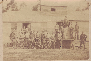
Photograph, 'Glenfine' Shearing Shed, 1890
In July 1840, Glenfine, consisting of 31,440 acres, was acquired by Thomas Downie. In March 1842 the 'Right of Run' was taken up by Thomas Chirnside who with an imported stallion 'Delapre' ran a horse stud. He apparently lived here for ten years and employed a gardener with a wife and five children from Hobart, Tasmania. Only some blocks of stone and a few trees remain of their homestead. In 1853 the property was transferred to Dr. John Chirnside, an elder brother of Thomas Chirnside. In 1857, William Rowe of Naringal purchased Glenfiine where he and his family lived until 1904 when it was bought by Richard Howell's estate. It was then 39,000 acres. The present house was built by the Rowes in 1872 of bluestone quarried on the property with a cement render overall. The architect was H.R. Casselli. Gold was found on the property and by 1898 the township of Hollybush was first reported, situated at either side of the front entrance, on the Cressy Road. The land for the township was given by William Rowe. In 1911 R.C. Howell, son of Richard Howell, became the owner, followed by his son in 1960. By 1990 Hollybush had a population of 426 persons. All of the early history of Glenfine, documents etc., were destroyed when Naringal homestead was burnt down in 1944. Glenfine was classified by the National Trust in 1974 and is on the Heritage Commission Register. Mounted black and white image of a large group of men and boys in front of a weatherboard shearing shed. The men are each holding a pair of hand shears. One young man is kneeling on top of a wool bale. A small blue biro 'x' identifies W. Todd. Glenfine was a pastoral station, and the original homestead still stands.shearing sheds, shearers, rural activity, william todd, glenfine pastoral station, thomas chirnside, thomas downie, richard howell, william thomas rowe -
 Bendigo Historical Society Inc.
Photograph - FORTUNA COLLECTION: ARCHWAY FORTUNA GARDEN
Black and white photograph of stone archway and pathway, Fortuna gardens.bendigo, house, fortuna villa -
 Eltham District Historical Society Inc
Document - Property Binder, 616 Main Road, Eltham; Plum Cottage
Plum Cottage is covered by Heritage Overelay HO256 in the Nillumbuk Planning Scheme This two-lot land holding was created as a subdivision and sold to Charles Stuart McNeil by May 1955. Sometime in the period 1955-1960, the builder-designer, John Harcourt had created a pise house on the site, straddling the two subdivision lots. The designer, John M. Harcourt was a pioneer builder in pise-de-terre and mudbrick in the Eltham Shire, Eltham being synonymous with alternative lifestyles and building practises until the onset of suburbia in the late 20th and early 21st centuries. This hipped-roof house is set high above Main Road on a V-shape plan characteristic of the Arts & Crafts style, with rammed earth or pise walls, timber joinery and a cement tiled roof. The V shape plan was used by important English and Eltham Arts & Crafts designers. The use of natural materials such as stone and timber construction is an essential part of the Arts & Crafts style and Harcourt’s work. So too is the application of the style on both the exterior and interior of the house as a holistic concept. The house adjoins the Lim Joon adobe house built and designed by Alistair Knox in the same era (HO119), thus forming a distinctive pair, both using an uncommon plan form. This house was identified in the Shire of Shire of Eltham Heritage 1992 as contributory to the Eltham Gateway Conservation Area, then proposed as an urban conservation area (now Heritage Overlay Area). Land Ownership Emily Jane Smith of 12 Woodside Street Fitzroy owned Crown Allotments 1 & 2 Sections 14, 27 by August 1918, selling to William Henry Smith of 12 Woodside Street, Nth Fitzroy May 1921. (John) James Isherwood of Main Road, Eltham owned the property by 1928 (the year of his death) with the beneficiary of his estate and next owner of this site being his widow, Minnie Maria Isherwood of Cemetery Road, Eltham. His holding in Main Road included parts of what was described in rate records as allotments1 & 2 Section E6. In the late 1930s, early 1940s her son Alfred John Isherwood was also rated for the land around this site, with the rated nett annual value varying between £2 and £5. Alfred Isherwood also lived at Main Road, Eltham with his wife Ellen: her early death at the age of 24 was reported in the Argus of 1923. Part of the Isherwood land was divided off and sold to Charles Stuart McNeil by May1955. Sometime in the period 1955-1960, the builder-designer, John Harcourt had created a pise house on the site, straddling the two subdivision lots. The house is visible on an aerial photograph from 1960s. Reputedly the house was called Plum Cottage and erected for Harcourt’s mother-in-law. A garage was added in 1959. Charles McNeil died in1971 aged 87: he was the son of Don McNeil and Margaret Arkell. Available rate records from the construction era start in the of the 1970s (1972-3) and list Mr H.C. & M/S A.V. Charity at 616 Main Road Eltham of this property with a nett annual value of $740. More recent valuer's data describes the property as lots 1 & 2 LP25668, located in the Central Riding of Eltham Shire, owned by Ann Valerie Charity and later, in 1990, by the Chincarini family. Building Description This hipped roof 11 .5 square house is set high above Main Road on a characteristic-shape plan and has rammed earth or pise walls, timber joinery and a cement tiled roof. The V-shape plan was used by Important designers such as C.F.A. Voysey (UK) who interpreted medieval domestic architecture as part of the Arts & Crafts style of the late 19th and early 20th centuries. The pise walls are covered with a textured render while the cement roofing tiles are also seen in the Harcourt Hill examples. Reputedly the ceiling joists are of a deep section and span long lengths with no need for hanging beams in the roof space. The ceilings are low and panelled in main rooms with apparently Caneite soft board infill panels between the exposed ceiling beams. These are painted white but may have been stained at one time. The focus of the house is the large living area with its vast random stone fireplace. Significance Plum Cottage is significant to the locality of Eltham because: Historically: • Plum Cottage is closely associated with the important historical theme of earth construction evident in Eltham and elsewhere in the Shire since theear1y Arts & Crafts inspired creations at Penleigh Boyd's The Robins (1912, HO101) and those at Montsalvat (1934-, HO82) but more prominent from the Second War period when earth building in Eltham was promoted in national periodicals as an alternative building method that avoided the building materials shortages of that era; • The choice of the earth building technique also expresses the theme of refuge or alternative living, synonymous with Eltham in the early to mid 20th century; • as a good example of domestic architecture from John Harcourt who was the first major post Second War figure in an important phase of Eltham’s earth building development, using his characteristic Old English or Arts& Crafts style that relies in this case on the pise wall construction, pitched roof forms, exposed ceiling joists, half timbering, random stonework, and panelled internal wall finishes. Architecturally: • Plum Cottage's pise wall construction is uncommon among the early earth-walled structures in the Shire, that are mainly of adobe or mud brick, and as a building material is uncommon among the Shire’s suburban dwellings generally which are clad typically with either fired clay bricks or timber boarding. Aesthetically: • Plum Cottage is a good and well preserved example of a modern Old English or Arts & Crafts style earth-walled building in the Shire • For the proximity of the significant Lim Joon adobe house designed by Alistair Knox adjoining to the north, providing a distinctive earth wall house pair, with uncommon plan forms. Reference Heritage Assessment of Plum Cottage, 616 Main Road, Eltham; Graeme Butler & Associates 2010main road, eltham, property, houses, (john) james isherwood, alfred john isherwood, ann valerie charity, arts and crafts style, charles stuart mcneil, chincarini family, eltham gateway zone, emily jane smith, h.c. charity, heritage assessment, john harcourt, john m. harcourt, lim joon house, main road eltham, minnie maria isherwood, pise construction, plum cottage -
 Bendigo Historical Society Inc.
Document - NEW CHUM & VICTORIA LINES OF REEF - NOTES ON THE VICTORIA REEF GOLD MINES COY
Handwritten notes describing the journey along Eaglehawk Road from the houses, poppet heads and mine tailings, etc. When the alluvial diggings were showing signs of exhaustion, and the fear arose that Bendigo was 'about done', two 'darkies' One named Dido, struck golden stone. They sold out to Ballerstedt and Son, and thus gold mining was revived. These areas were remarkable for the extraordinary richness of the lodes, and the singular manner in which the gold is distributed.document, gold, new chum & victoria lines of reef, notes on the victoria reef gold mines coy, gavan duffy, victoria hill, black lead, prince alfred, ballerstadt & son, goldfields registry, mr macartney, wittscheibe, luffsman -
 Old Colonists' Association of Ballarat Inc.
Photograph - Photograph - Colour, The entrance foyer of the Old Colonists' Club, 2015
From the Argus Newspaper of 10 May 1888: "OLD COLONISTS' ASSOCIATION OF BALLARAT. (FROM OUR CORRESPONDENT.) BALLARAT, WEDNESDAY. This association, which was founded in August, 1883, and at first known as the Old Identities' Association, now has a roll of 450 members. The objects of the association are "to aid and assist indigent or suffering old colonists; to raise a fund, by the voluntary subscriptions of the members and the aid of outside donations, for the purpose of relieving members in sickness and old age ; for assisting those in extreme distress, to provide the shelter o a home for old and indigent pioneers of the gold fields, their widows, or anyone connected with the association, and in the event of the death of any member to have his remains decently buried, the association defraying the expenses of the funeral (providing that no funds or property are left by the deceased), and to attend the funeral if so desired by the relatives " The qualifications for member- ship are good character and repute, and residence in the colonies for a quarter of a century. For some time the association had no property except the regular subscriptions, but about a year ago they obtained from the Minister of Lands the grant of a very valuable block of land in Lydiard-street, the Crown grant of which they received last week. This block has a frontage of 66ft to Lydiard street, worth at least £100 a foot. The ground was given to the association as a site for them to build a hall upon, and with so valuable an asset they had no difficulty in borrowing at 7 per cent, enough money to construct a hall. For revenue purposes the ground floor of the building has been made into four shops, and the rental from these, judging from the rentals of shops in the vicinity, will not only pay all the interest on the borrowed money, but over £200 a year towards clearing off the principal. The officers of the association are Messrs J P Murray, president; J W Graham and T. Stoddart, vice presidents; D Fern, treasurer , and J Fraser, secretary. The Old Colonists' Hall is an elegant looking building in Lydiard-street, lying between the newly-opened mining exchange and the Commercial Club house, and a few doors north of the Post office. The style of the facade is classic. The lower portion of the front is constructed of Waurn Ponds stone, forming piers, and the upper portion of brick and cement, the background being tuckpointed. The centre bay is carried by two three quarter columns with Ionic cups, which support a pediment on which is set a cast of the Ballarat coat of arms. The four other bays are supported by pilasters with Corinthian caps mid partly fluted. The entrance is through a spacious circular headed doorway, the keystone of the arch of which bears a sculptured head, in marble, representing that of the president of the Old Colonists' Association here, Mr. John P Murray. An ample vestibule leads to a wide stone staircase which ends at a spacious landing. The landing has a dome over the centre, with cornice and enrichments, and is lighted from above. The walls round the landing are panelled with marble slabs, which are to be appropriately inscribed in the future. On the first door are the rooms appropriated to the association. The principal of these is a hall 44ft x 33ft and 17ft high. This room is well ventilated and lighted from the back of the building with large windows, and the walls are finished with Keene's cement. The other rooms are committee room, 14ft x 16ft; scretary's, 14ft x 17ft 6in; kitchen, bedrooms, bathroom, &c. The front portion of the first floor is arranged so that it may be let for offices, or utilised for club purposes. Suitable provision has been made throughout tor lighting, ventilation, and means of egress. The architect for the edifice is Mr A. G Legge, of this city, and the contractors are Messrs. Whitelaw and Atkinson, Irving and Glover, Reynolds, and J Donaldson. The total cost of the building when completed, which will be in a few weeks, will be about £4,000."Colour photograph of a room with marble plaques on the wall. They relate to the Old Colonists' Association of Ballarat, old colonists' association ballarat, old colonists' club, marbles -
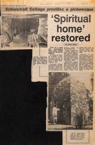 Whitehorse Historical Society Inc.
Newspaper - Article, 'Spiritual Home Restored', 22/12/1982
Newspaper cutting describing the restoration of Schwerkolt's house. Johann August Schwerkolt, born in Goltberg, Germany in 1882, came to Australia in 1849. Cottage built of local stone and wood in 1862.schwerkolt, paulina, johann august, richter -
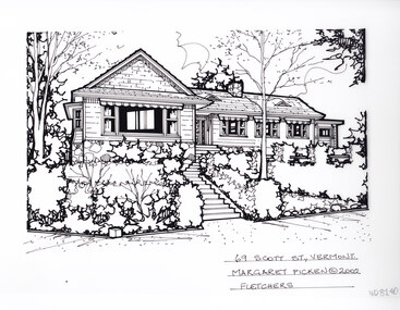 Whitehorse Historical Society Inc.
Artwork, other - Ink Line Drawing, Margaret Picken, 69 Scott St., Vermont, 2002
... Picken, of a single story weatherboard house atop a stone... story weatherboard house atop a stone subfloor facade, and set ...A property illustration by Margaret Picken Commissioned by a real estate agency for the purpose of advertising 69 Scott St., Vermont. This property is listed as having sold for $655,000 in 2002 Made by using Rotring ‘Rapidigraph’ drafting pens with Rotring ink on Rapidigraph polyester drafting film, double matte. Trained as a cartographic draftsman within the mining industry, Margaret Picken is an artist who worked producing property illustrations for real estate agencies in eastern suburbs of Victoria from 1983-2005. Retiring from the industry as technological changes favored coloured photography over illustrations, and commissioning companies over sole contractors.This artwork is of Historical Significance as a record of local domestic architecture.A black ink line drawing on drafters film by Margaret Picken, of a single story weatherboard house atop a stone subfloor facade, and set back from a sloped front garden. In the middle of the image are steps trailing up to the front door.69 Scott St., Vermont. Margaret Picken © 2002 Fletcherswhitehorse historical society, schwerkolt cottage, housing, architecture, margaret picken, house, garden, real estate, vermont, vermont south -
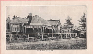 Sunbury Family History and Heritage Society Inc.
Photograph, ST. MARY'S VICARAGE, c1920
The Federation style house was the former vicarage for St. Mary's Church in O' Shanassy Street, Sunbury. It replaced the former 'Priorswood' vicarage, which was in Station Street about a mile from the church. The foundation stone for the new vicarage was laid by Mrs. Russell Clarke on 21st February 1914 and was opened by His Grace the Archbishop of Melbourne on 10th June 1914. A non-digital black and white photograph with a cream border across the top and base of the image off a brick federation style home with a corrugated iron roof. It has a return verandah with a decorative wooden trip under the eaves. A car is parked in the street by the gate and there are two buildings behind the house.st. mary's church of england, sunbury, vicarages, o'shanassy street -
 University of Melbourne, Burnley Campus Archives
Album, Jan Chamberlain, Friends of Burnley Gardens Achievement Book, 2000
... sir rupert hamer open gardens scheme ellis stones rock garden ...camellia planting ceremony, kay hirst, a w jessep, dorothy jessep, tom kneen, andrew smith, camellia japonica 'a w jessep', camellia japonica' dorothy jessep', friends of burnley gardens, fobg, sir rupert hamer, open gardens scheme, ellis stones rock garden, ellis stones, australian plants society, grasslands project, 150th birthday celebration, pruning day 2000, planting ellis stones rockery 2000, summer house, shelter shed, native garden, herb garden, grey garden, orchard, field station, bulb bed, working bee, twilight working bee, ikebana exhibition -
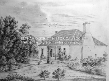 Eltham District Historical Society Inc
Negative - Photograph, Charles Bertie, Sketch; Sweeney's Cottage, Culla Hill, Eltham (n.d.), c.1905
In the early 1900s, Mary Sweeney commissioned artist Charles Bertie to paint the main house at Culla Hill. He charged her 5 shillings for the picture and 18 pence for the frame She took this painting with her when she married Michael Carrucan in 1910 and it hung in the Dalton Street farmhouse for many years. At a later time (1960s), the Burstons (the then owners of Culla Hill) had a card printed from the painting. The original sketch was photographed in 1970 for reproduction in the Shire history publication Pioneers & Painters (1971). The very fragile original was kept in the Council strongroom and suffered significant damage to its edges over the years, no doubt it has also yellowed. A comparison of the original as digitised (2022) with the negative taken 50 years earlier also reveals that the left 20% of the sketch has been cut off, probably due to damage. In June 1842 Thomas Sweeney applied to the Superintendent, C.J. La Trobe, asking permission to purchase a portion of the recently surveyed ‘Parish of Nillumbik'. His request was allowed and handed to the sub-treasurer and Land Board. He paid £110 for 110 acres and called the land 'Culla Hill'. He first built a temporary house, a slab hut 12 feet by 10 feet, in which he lived with his wife, an Irish girl whom he had married in 1838. (His first wife had been drowned at Port Jackson.) Some time later he built a permanent residence on the model of a Tipperary farmhouse. It was a rectangular building of hand-made bricks and stone quarried from the Western Hill with a recessed verandah in front, and bore a slate roof. The out-buildings consisted of a detached kitchen, stable and a barn. It was in this house that succeeding generations of Sweeneys were reared. The original slab hut became a washhouse and survived till recent years. 'Culla Hill' became a social centre for the district, church services being held there on various occasions. The first wheat crop in the district was planted by Sweeney who also supplied the first grain for a mill that later was built at Eltham. He took an active interest in the development of the district. At this time travelling people--many of them runaway sailors or convicts--often passed the settlement, and some of them stayed and worked with Sweeney. A tribe of aborigines living on the river below 'Culla Hill' were apparently on good terms with Sweeney, for it is said that they helped him with the building of his house. Very little is known about the aborigines who originally lived in the Eltham district. There must have been many of them; their stone axes, grinding stones, and anvil stones have been found in the gullies around Research and canoe trees and artifacts were found on the Kangaroo Ground hills. Early settlers remembered a tribe that camped on the site of the present railway bridge at Eltham. They held corroborees there and visited settlers for hand-outs of 'flour and bacca’. There was an aboriginal reserve on the Yarra, upstream from Eltham, but most of those who had collected there later went to live on the Pound Reserve at Warrandyte, where the last aborigines in the area finally ended their days. The Pound Reserve, of 1,103 acres, was established at Pound Bend in 1841. The chief protector, George Robinson, and his four assistants, were given instructions to care for the aged and sick, to provide blankets and rations for all who lived there, to train the able-bodied men in agriculture and other trades and to find them jobs. The Yarra blacks, who later came under the protection of William Thomas, have been described as a 'fine race, well made and above the average height'. Thomas Sweeney died on 6 September 1867 and was buried in the Eltham Cemetery. To his wife Margaret and his son John, he left the entire property of 'Culla Hill'. To his other son Patrick, he left 150 acres, including a small two-roomed wooden cottage. He had five daughters: Kate and Margaret (twins) who were born in 1842, Ellen 1846, Annie 1848 and Johanna 1851. John Sweeney farmed 'Culla Hill' until his death in 1909. He had ten children; one of them, Mary, became Mrs M. Carrucan whose son, Mr John Carrucan, still lives at Eltham. 'Culla Hill' passed out of the Sweeneys possession in 1939 and was renamed by its new owners, 'Sweeneys', in memory of its pioneers. - Pioneers & Painters: One Hundred Years of Eltham and its Shire, Alan Marshall 1971, pp10-12 Original colour sketch artwork 4 x 5 inch black and white negative of original colour sketchculla hill, art, charles bertie, drawing, mary carrucan (nee sweeney), sketches, sweeney's cottage -
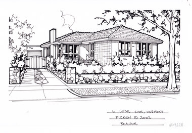 Whitehorse Historical Society Inc.
Artwork, other - Ink Line Drawing, Margaret Picken, 6 Lusk Dve., Vermont, 2002
A property illustration by Margaret Picken Commissioned by a real estate agency for the purpose of advertising 6 Lusk Dve., Vermont This property is listed as having sold for $270,000 in 2004 Made by using Rotring ‘Rapidigraph’ drafting pens with Rotring ink on Rapidigraph polyester drafting film, double matte. Trained as a cartographic draftsman within the mining industry, Margaret Picken is an artist who worked producing property illustrations for real estate agencies in eastern suburbs of Victoria from 1983-2005. Retiring from the industry as technological changes favored coloured photography over illustrations, and commissioning companies over sole contractors.This artwork is of Historical Significance as a record of local domestic architecture.A black ink line drawing on drafters film by Margaret Picken, of a single story brick house. On the left is a driveway leading to a gated garage in the background. While in the right foreground is a low stone fence enclosing a front yard with hedging. There are two hole punch holes just below centre of the upper edge6 Lusk Dve., Vermont Margaret Picken © 2002 Realatorwhitehorse historical society, schwerkolt cottage, housing, architecture, margaret picken, house, garden, real estate, vermont, vermont south -
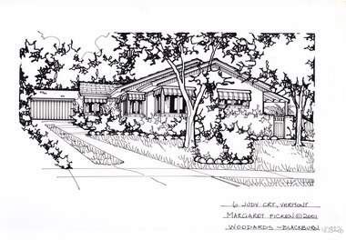 Whitehorse Historical Society Inc.
Artwork, other - Ink Line Drawing, Margaret Picken, 6 Judy Crt., Vermont, 2001
A property illustration by Margaret Picken Commissioned by a real estate agency for the purpose of advertising 125 Jolimont Rd., Vermont This property is listed as having sold for $225,500 in 2001 Made by using Rotring ‘Rapidigraph’ drafting pens with Rotring ink on Rapidigraph polyester drafting film, double matte. Trained as a cartographic draftsman within the mining industry, Margaret Picken is an artist who worked producing property illustrations for real estate agencies in eastern suburbs of Victoria from 1983-2005. Retiring from the industry as technological changes favored coloured photography over illustrations, and commissioning companies over sole contractors.This artwork is of Historical Significance as a record of local domestic architecture.A black ink line drawing on drafters film by Margaret Picken, of a black and white line drawing of a single story brick house, with a driveway on the left leading to a connected garage in the background. In the foreground is a front yard with garden beds edged with stone boarders. There are two hole punch holes just below centre of the upper edge6 Judy Crt., Vermont Margaret Picken © 2001 Woodards - Blackburnwhitehorse historical society, schwerkolt cottage, housing, architecture, margaret picken, house, garden, real estate, vermont, vermont south -
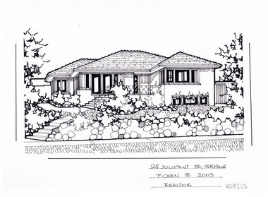 Whitehorse Historical Society Inc.
Artwork, other - Ink Line Drawing, Margaret Picken, 125 Jolimont Rd., Vermont, 2003
A property illustration by Margaret Picken Commissioned by a real estate agency for the purpose of advertising 125 Jolimont Rd., Vermont This property is listed as having sold for $351,000 in 2003 Made by using Rotring ‘Rapidigraph’ drafting pens with Rotring ink on Rapidigraph polyester drafting film, double matte. Trained as a cartographic draftsman within the mining industry, Margaret Picken is an artist who worked producing property illustrations for real estate agencies in eastern suburbs of Victoria from 1983-2005. Retiring from the industry as technological changes favored coloured photography over illustrations, and commissioning companies over sole contractors.This artwork is of Historical Significance as a record of local domestic architecture.A black ink line drawing on drafters film by Margaret Picken, of a black and white line drawing of a single story brick house, with steps from the footpath leading up to a raised porch. In the foreground is a stone retaining fence enclosing a front yard with garden bed edging. There are two hole punch holes just below centre of the upper edge125 Jolimont Rd., Vermont Picken © 2003 Realtorwhitehorse historical society, schwerkolt cottage, housing, architecture, margaret picken, house, garden, real estate, vermont, vermont south