Showing 1860 items
matching the rock
-
 National Vietnam Veterans Museum (NVVM)
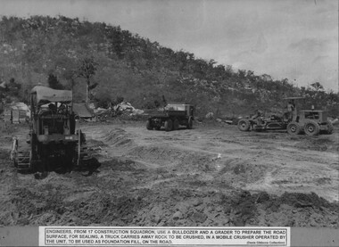
Photograph, Road Construction
A black and white photograph of Engineers from 17 Construction Squadron use a bulldozer and road grader to prepare the road surface for sealing. A truck carries away rock to be crushed, in a mobile crusher operated by the Unit, to be used for foundation fill, on the road.photograph, engineers, 17 const sqn, gibbons collection catalogue -
 Clunes Museum
Film - VIDEO
PRIMARY SCHOOL PERFORMANCE: KIDS IN SPACE SEPT 5 AND 6 SINBAD SAILS AGAIN SEPT 3 AND 4 2003.1 VIDEO KIDS IN SPACE - ROCK MUSICAL LYNNE BARTLETT, KEVIN O'MARA, ROB FAIRBAIRN, MARK LEAHY .2 VIDEO SINBAD SAILS AGAIN - AMUSICAL ODYSSEY L. BARTLETT, ROB FAIRBAIRN. MARK LEAHY , KEVIN O'MARAkids in space, sinbad sails again -
Tatura Irrigation & Wartime Camps Museum
Document, Money of the Internment Camp, 1989
Unknown, but a most of interesting and well illustrated publication.plastic folder, clear cover, red flat and continues to the back cover. Top of the front page 6 coins on rock and "Money of the Internment Camp" Notes designed at Hay Camp and internment camp cantee coins - articles by David Allen.as above.internment camps, internment camp currency, david allen -
Lakes Entrance Regional Historical Society (operating as Lakes Entrance History Centre & Museum)
Book, M Holding, Serious Accidents, 2010
A folder containing inquests inquiries into accidental deaths associated with various types of mining. James Roadknight taking rocks from Granite Rock for entrance works, Francis William Robinson delivering supplies to oil bure and Thomas Douglas Hollingsmines and mining, oil and gas industry, construction -
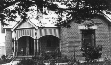 Stawell Historical Society Inc
Photograph, St. Matthew’s Presbyterian Church -- second manse 1923
St. Matthew’s Church Stawell second Manse built 1923. Single story brick house with small decorative timber verandah entrance with iron roof. A rocking horse is on the entrance verandah near front door. Large pine tree branches overhanging top section of photo with low plants in garden.New Manse built 1923stawell religion -
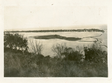
Lakes Entrance Regional Historical Society (operating as Lakes Entrance History Centre & Museum)
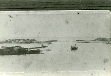
Photograph, Eastwood Bros, 1889c
Sepia photograph showing the just opened Entrance to Bass Strait. Sand not completely cleared from channel, buildings on dunes, dredge Wombat moored off Bullock Island. Rock groynes being built in lake. Lakes Entrance Victoriawaterways, islands, jetties, houses -
 Lakes Entrance Regional Historical Society (operating as Lakes Entrance History Centre & Museum)
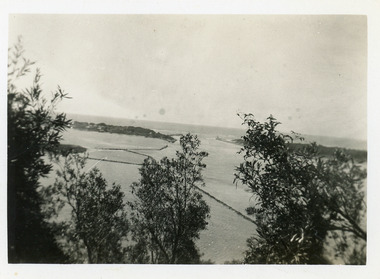
Photograph - Bullock Island, 1930c
Black and white photograph of Bullock Island, showing the footbridge to the island, the rock groynes at the western end of the island, built to direct flood and tide waters to entrance. Photo taken from Kalimna Hill, scub in foreground. Lakes Entrance Victoriawaterways, islands, township -
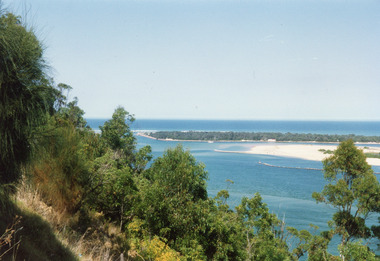 Lakes Entrance Regional Historical Society (operating as Lakes Entrance History Centre & Museum)
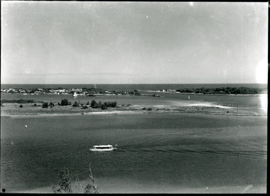
Photograph - The Entrance, 1992c
Colour photograph of the western side of the Entrance. It shows scrub covered hummocks, dredged sand dumped at Snake Island, rock groynes from island to lake, taken from lower side of highway at Jemmys Point. Lakes Entrance Victoriaislands, topography, waterways -
 Lakes Entrance Regional Historical Society (operating as Lakes Entrance History Centre & Museum)
Photograph - Wombat, 1890c
1 other photograph 10 x 16 archived.Black and white photograph showing view of entrance, dunes and Bullock Island, buildings and dunes at left, building and jetty and rock groynes on Bullock Island. Vessel near centre may be the Carpenter owned dredge the Wombat. Lakes Entrance Victoria jetties, dredges, waterways -
 Lakes Entrance Regional Historical Society (operating as Lakes Entrance History Centre & Museum)
Postcard - The Entrance, 1935c
Also small format identical postcard 6.5 x 8.5, very faded,|also small format photo, same view donated by D & M FletcherBlack and white small format postcard of the man made entrance to the Gippsland Lakes, taken from Jemmys Point. It shows the rock groynes beside Bullock Island, a barge in North Arm below Jemmys Point. Lakes Entrance VictoriaThe Entrance to Gippsland Lakes waterways, topography -
 Whitehorse Historical Society Inc.
Artwork, other - Ink Line Drawing, Margaret Picken, 21 Dalmor Ave., Mitcham, 2003
A property illustration by Margaret Picken Commissioned by the real estate agency Woodards Blackburn for the purpose of advertising 1 Dalmor Ave., Mitcham. This property has be listed as having sold for $430,000 in 2003. Made by using Rotring ‘Rapidigraph’ drafting pens with Rotring ink on Rapidigraph polyester drafting film, double matte. Trained as a cartographic draftsman within the mining industry, Margaret Picken is an artist who worked producing property illustrations for real estate agencies in eastern suburbs of Victoria from 1983-2005. Retiring from the industry as technological changes favored coloured photography over illustrations, and commissioning companies over sole contractors.This artwork is of Historical Significance as a record of local domestic architecture.A black ink line drawing on drafters film by Margaret Picken, of 21 Dalmor Ave., Mitcham depicting a black line drawing of a weatherboard house with chimney, in the foreground a rock boarded garden and path leading from the left to the front door. 21 Dalmor Ave., Mitcham Picken © 2003 Realtorwhitehorse historical society, schwerkolt cottage, housing, architecture, margaret picken, house, garden, real estate, mitcham -
 Lakes Entrance Regional Historical Society (operating as Lakes Entrance History Centre & Museum)
Photograph - Bullock Island, Silver Reflections Studio, 1920c
Black and white photograph showing Bullock Island, Entrance to Bass Strait, buildings on sand dunes, yacht sailing on Cunninghame Arm, tourist launch in foreground, rock groynes around west end of Bullock Island. Lakes Entrance Victoriawaterways, room display, islands -
Coal Creek Community Park & Museum
Cardboard box, Semco Art Needlework Pty Ltd
White rectangular box with blue and gold advertisement, 'Silkette Machine Twist' with map of Australia.Silkette Machine Twist, Silk Substitute, Silkette machine Twist, Semco A.T.C. No.40, 80 yards. Semco Art Needlework Pty. Ltd. "Semco Park" Black Rock, Victoria. Trade Mark. -
Tatura Irrigation & Wartime Camps Museum
Photograph, Eildon Reservoir - Goulburn River, 1918
Taken by photographer for State Rivers and Water Supply Commission.Medium sized black and white photograph. Eildon Reservoir on the Goulburn River / Overall picture of dam (Right of wall) filled with water and some leisure craft moored near shore and huts / Dam wall and spillway / tree covered hills beyond"Eildon Reservoir - Goulburn River / Capacity - 306,000 acre feet / Rock filled dam with mass concrete spillway / Total length of dam - 3000 feet / Maximum depth of water - 123 feet - etc"victorian state rivers and supply commission, eildon dam -
Stawell Historical Society Inc
Archive - Docket Book, Stawell Florist, 1989
Business, FloristWhite Cardboard Blue Writing - Back in Blue Calendar 1989Dianne Ross Stawell Florist 82 Main Street Stawell 3380 Phone (053) 583799 A.H. (053) 582785 A member of Inter flora Pen Drawing inside - Inlet with beach trees & rockbusinesses -
 Eltham District Historical Society Inc
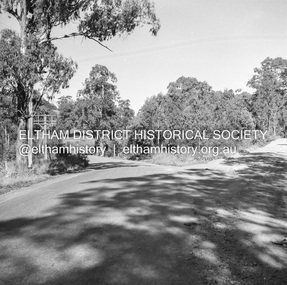
Negative - Photograph, J.A. McDonald, Heidelberg-Kinglake Road, Mar. 1960
Cherry Tree Road Job 56F443 Contractors Wolf and Wood Junction of Cherry Tree and Flat Rock Roads – old alignment Looking along new alignment March 1960Record of various Shire of Eltham infrastructure works undertaken during the period of 1952-1962 involving bridge and road reconstruction projects, sometimes with Eltham Shire Council Project Reference numbers quoted. It was during this period that a number of significant improvements were made to roads and new bridges constructed within the shire that remain in place as of present day (2022). In many situations, the photos provide a tangible visible record of infrastructure that existed throughout the early days of the Shire. The album was put together by or under the direction of the Shire Engineer, J.A. McDonald.infrastructure, 1960-03, bridge construction, cherry tree road, heidelberg-kinglake road, road construction, shire of eltham, flat rock road -
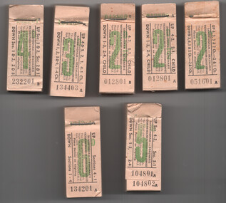 Melbourne Tram Museum
Ephemera - Tickets - Victorian Railways Sandringham to Beumaris Motor Coach, Victorian Railways (VR), mid 1950s
Tickets printed and issued by the Victorian Railways for the Sandringham to Beaumaris motor coach (bus) service, following the closure of the tramway to Black Rock in 1956. All tickets numbered for accounting purposes.Yields information about the VR Ticketting System for its Tramways and motor coach services.Set of 7 Victorian Railways Sandringham to Beumaris Motor Coach ticket blocks. Printed on white sheets, stapled at the top with a large staple onto a cardboard backing strip. Each value in green ink with black print information. Each block has the ticket number printed on the stub of the ticket that remained with the block when torn off. Were printed in blocks of 200. 1 - 2d - Nos. 051601 to 051788 - cardboard backing strip, front and some rear tickets removed 2 - 2 1/2d - Nos. 012801 012993 - series A - Child - cardboard backing strip, front and some rear tickets removed 3 - 2 1/2d - Nos. 012801 012999 - series B - Child - front ticket removed 4 - 3d - Nos. 134403 to 134589 - front and rear tickets removed 5 - 4d - Nos 232201 to 232392 - cardboard backing strip, front and some rear tickets removed 6 - 5d - Nos 104801 to 104994 - front and rear tickets removed. 7 - 6d - Nos 134201 to 134393 - cardboard backing strip, front and some rear tickets removedtickets, vr, vr trams, victorian railways, fares, sandringham, black rock tramway, beaumaris -
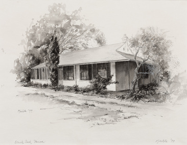 Bayside Gallery - Bayside City Council Art & Heritage Collection
Work on paper - ink and watercolour, Annette Meikle, Black Rock House, 1977
In 1977, artist Annette Meikle undertook a commission to illustrate a book recording stories of places and people in the Bayside area. It was published in 1978 as Sandringham Sketchbook, with text by Elizabeth Waters. The sketches were intended to record remaining examples of Bayside’s early architecture and environment, as well as reflect newer architectural changes. Meikle went on to donate 22 of these sketches to Bayside City Council in 2003. Black Rock House was built in 1858 by wealthy land dealer and politician Charles Hobson Ebden as a holiday home on 112 acres of virgin scrub, taking in the area of present day Balcombe Road, Beach Road and the line of Keating Street. The house included four bedrooms, a cellar, stables and a courtyard enclosed in castle-like sandstone walls. It was named Black Rock House after Black Rock Castle near Dublin, associated with Mrs Ebden’s childhood.Annette Meikle, Black Rock House 1977, ink and watercolour, 33 x 53.5 cm. Bayside City Council Art and Heritage Collection. Donated by the artist, 2003annette meikle, sandringham sketchbook, elizabeth waters, black rock house, black rock, charles hobson ebden, architecture, historic house -
Bendigo Historical Society Inc.
Photograph - KEN BICE COLLECTION: HUSTLERS ROYAL RESERVE MINE, BENDIGO. 1905
Copy of photo: on back of image face of drive, Hustler's Royal Reserve Mine, Bendigo, C 1905?' Image shows four men standing around a rock drill, one man in foreground pushing an ore bin. This is a digital only photograph.bendigo, mining, hustler's royal reserve mine, bendigo, hustlers royal reserve mine -
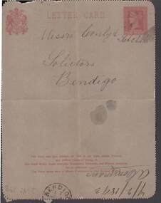 Bendigo Historical Society Inc.
Document - CONNELLY, TATCHELL, DUNLOP COLLECTION: LETTER FROM A. COMMANS
Lettercard, grey with red writing, one penny stamp image printed thereon, from A. Commans, Bald Rock, 7/2/93, re cheque being posted on Friday or Saturday. Red one penny stamp image at the top of the document .business, legal, a. commans -
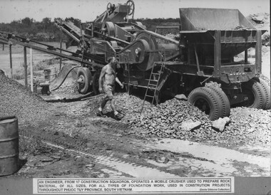 National Vietnam Veterans Museum (NVVM)
Photograph, Mobile Crusher 1
A black and white photograph an Engineer from 17 Construction Squadron operates a mobile crusher used to prepare rock material, of all sizes, for all types of foundation work used in construction projects throughout Phuoc Tuy Province, South Vietnamphotograph, engineers, 17 const sqn, phuoc tuy province, gibbons collection catalogue -
 National Vietnam Veterans Museum (NVVM)
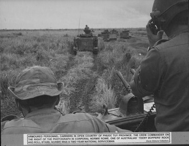
Photograph, On Patrol
A black and white photograph of Armoured Personnel Carriers in open country in Phuoc Tuy Province. The crew Commander on the right of the photograph is Corporal Normie Rowe, one of Australias :teeny boppers" rock and roll stars. Normie was a two year National Serviceman.photograph, apc, phuoc tuy province, cpl normie rowe, normie rowe, gibbons collection catalogue -
Clunes Museum
Tool - GOLD CRADLE & PANNING DISH, JAMES ESMOND, CIRCA 1850
USED TO OBTAIN ALLUVIAL GOLD THE DESIGN OF THIS EQUIPMENT IS MOSTLY BASED ON THE PRINCIPLE OF THE WAY HEAVY MINERALS ARE CONCENTRATED IN ALLUVIAL DEPOSITS. THE PROSPECTING DISH IS USED WHEN WORKING WITH SMALL AMOUNTS OF STONES & CLAY WHILE BIGGER JOBS THE CRADLE OR BANJO IS MORE EFFICIENT. THE GAUZE OF MESH IN THE SIEVE IS VARIABLE. THE CRADLE OR BANJO IS USUALLY SET UP AT RIGHT ANGLES TO A SHALLOW CREEK OR WATERHOLE WITH THE OPEN ENDS TOWARDS THE WATER.1 WOODEN CONSTRUCTION MADE BY HAND WITH GAUZE FILTER IN UPPER SECTION TO SEPARATE QUARTZ ROCKS, SAND AND SOIL. A HANDLE ON BOX LIKE CONSTRUCTION IS USED TO ROCK THE CRADLE WHICH IS MOUNTED WITH ITS ROCKERS RESTING ON WOODEN BEARERS. .2 PANlocal history, mining equipment, mining -
Lakes Entrance Regional Historical Society (operating as Lakes Entrance History Centre & Museum)
Photograph, HD Bulmer, 1915 1920 c
Sepia toned photograph of west side of Red Bluff near Lake Tyers showing seven people on cliff top and two ladies seated on rock at beach, erosion under cliff, cliff top intact. Lakes Tyers Beach Victoriaclubs, environment -
 Lakes Entrance Regional Historical Society (operating as Lakes Entrance History Centre & Museum)
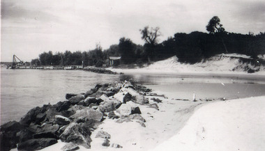
Photograph - Western sand Hummocks, 1946
Black and white photograph showing lake shoreline on western side of entrance piers, with rock retaining wall, walings and crane left middle distance and front of Schnapper cottage, dense vegetation on dune and some erosion to beach. Lakes Entrance Victoria machinery, waterfront, houses -
 Lakes Entrance Regional Historical Society (operating as Lakes Entrance History Centre & Museum)
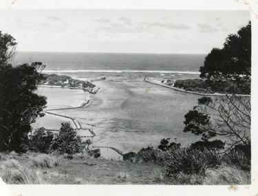
Photograph - The Entrance, 1930c
Black and white photograph showing wooden piers at entrance to Bass Strait from the Gippsland Lakes. Buildings on sand dunes, Bullock Island and rock groynes. Photo taken from Jemmys Point showing shrubbery in foreground. Lakes Entrance Victoriawaterways, topography, boats and boating, islands -
 Lakes Entrance Regional Historical Society (operating as Lakes Entrance History Centre & Museum)
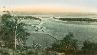
Postcard - The Entrance, Valentine Series, 1935c
Hand tinted postcard of the man-made entrance to the Gippsland Lakes, taken from Jemmys Point. It shows the rock groynes at Bullock Island and Entrance to North Arm, a barge in North Arm directly below Jemmys Point. Lakes Entrance Victoriaislands, waterways, topography -
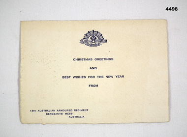 Bendigo Military Museum
Card - CARD, CHRISTMAS, 13th Aust Armoured Regt Sgt’s Mess, C.1942
Person sending is Robert James Rock Ball, VX103870, records show that he enlisted on 27.8.1942 age 32 years, discharged 16.4.1946 as a Cpl in No 42 Aust Landing Craft Coy.Christmas card, off white colour, front has Rising Sun badge at top, Xmas and New Year Greetings under, bottom left hand corner from”13th ARMD Regt Sgt’s mess Australia, all print in dark blue, rear has hand written details in blue ink.On rear,”To Miss Guiney, with best wishes for Xmas and New Year 1942, from Roc Ball, Sgt Ball VX103870 13th Australian ARMD Regt Australia”cards, christmas military -
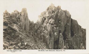 Phillip Island and District Historical Society Inc.
Sepia Photograph, Rose Series, 1920
Postcard photo showing rocks on the south side of Cape Woolamai, Phillip Island, Victoria. This formation was named Castle Rock. The Album was presented to the Earl of Stradbroke by Fathers of Soldiers of Phillip Island.Photograph of The Rocks at Cape Woolamai, Phillip Island, VictoriaRose Series P 3426 The Rocks, Cape Woolamai, Phillip Is., Vicphillip island, cape woolamai, earl of stradbroke, castle rock rock formation -
 Eltham District Historical Society Inc
Photograph, View to the Eltham Barrel from Main Road looking up Kalbar Road, c.1987
Note advertsing for Kids of Rock concert with Brian Cadd and Max Merritt and Joke Night with Shane Bourne at the Barrel. The Eltham Barrel was destroyed by fire on the evening of Sunday, June 4th, 1989Roll of 35mm colour negative film, 7 stripsKodak GA 100 5095roads, main road, kalbar road, brian cadd, eltham barrel, kids of rock, max merritt, shane bourne