Showing 1137 items
matching waterways
-
 Lakes Entrance Regional Historical Society (operating as Lakes Entrance History Centre & Museum)
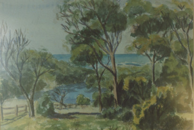
Photograph - Lake Bunga, 1980c
... Waterways ...Colour photograph of a painting by Rodney Symmonds showing lake between overhanging trees with ocean beyond, Lake Bunga Victoriatopography, waterways, forest -
 Lakes Entrance Regional Historical Society (operating as Lakes Entrance History Centre & Museum)
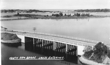
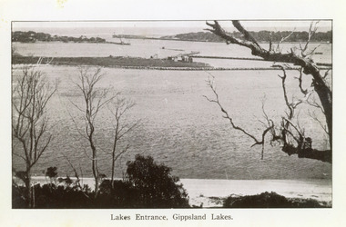
Postcard, The Lakes Studio, 1947
... Waterways ...Also identical image, good condition, clearer print, collected, also enlargement 16 cm x 25.5 cmBlack and white postcard taken from the path up Kalimna Hill, showing the concrete North Arm bridge; Bullock Island; New Works area and Western side of Entrance. Lakes Entrance VictoriaNorth Arm Bridge Lakes Entrancewaterways, bridges, coast -
 Lakes Entrance Regional Historical Society (operating as Lakes Entrance History Centre & Museum)
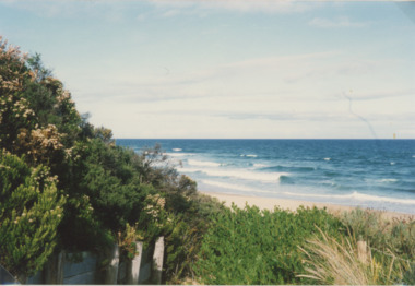
Photograph, 1992
... Waterways ...Colour photograph taken from the base at the Red Bluff looking to the south east shows low shrubbery on higher elevation above sandy beach, surf breaking with ocean beyond Lake Tyers Victoriaocean, waterways, sand dunes -
 Lakes Entrance Regional Historical Society (operating as Lakes Entrance History Centre & Museum)
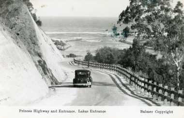
Postcard - The Entrance, Bulmer H D, 1930c
... Waterways ...Black and copy 9 x 13.5, has inscription 'Princes Highway and Entrance, Lakes Entrance', ink spill on photo top right hand areaTinted small format postcard of the Princes Highway winding around Jemmys Point, between the steep road cutting and post and rail fence, entrance to Gippsland Lakes in the distance. Lakes Entrance Victoria waterways, roads and streets, vehicles -
 Lakes Entrance Regional Historical Society (operating as Lakes Entrance History Centre & Museum)
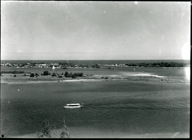
Photograph - Bullock Island, 1915c
... Waterways ...On back of original 'To Rit with love from Arthur' (Arthur Seagrove - Head Teacher, Johnsonville Primary School - 1920)Black and white photograph of Bullock Island and the man-made entrance from Bass Strait. It shows the Western end of Bullock Island, some natural vegetation, jetty and timber groynes, trading vessel standing outside entrance. Lakes Entrance Victoriawaterways, islands, topography -
 Lakes Entrance Regional Historical Society (operating as Lakes Entrance History Centre & Museum)
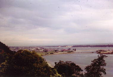
Photograph - The Entrance, 1995c
... Waterways ...Colour photograph of the entrance from Bass Strait to the Gippsland Lakes, it shows the western end of Bullock Island and the built up area below Jemmys Point, both made during dredging operations over many years. Lakes Entrance Victoriaislands, fishing industry, waterways -
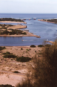 Lakes Entrance Regional Historical Society (operating as Lakes Entrance History Centre & Museum)
Photograph - The Entrance, 1995c
... Waterways ...Colour photograph of the entrance from Bass Strait to the Gippsland. It shows the western and of Bullock Island and the built up area below Jemmys Point, all made during dredging operations over many years. Lakes Entrance Victoriafishing industry, islands, waterways -
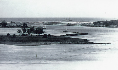
 Lakes Entrance Regional Historical Society (operating as Lakes Entrance History Centre & Museum)
Photograph - The Entrance, Martin Orville, 1940c
... Waterways ...Another copy Black and white 7 x 8.5 with inscription'View showing the Entrance, Lakes Entrance, Vic'Black and white photograph of Bullock Island, the New Works, township and entrance from Bass Strait to the Gippsland Lakes. Taken at high tide. Lakes Entrance Victoriaislands, waterways, topography -
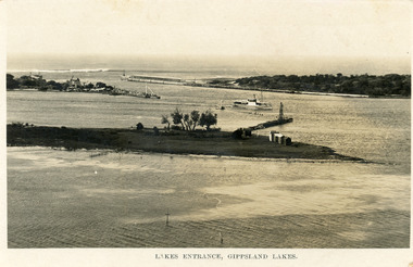 Lakes Entrance Regional Historical Society (operating as Lakes Entrance History Centre & Museum)
Postcard - Bullock Island, Bulmer H D, 1923c
... Waterways ...Also same image|Faded copy 10x15|Black and White 12x17.5|Black and White 20x28.5Black and white postcard of the entrance to the Gippsland Lakes, showing buildings at New Works, cranes on ends of piers, jetty and bathing boxes on bullock Island, steamer passing island. Lakes Entrance VictoriaLakes Entrance, Gippsland Lakeswaterways, islands, topography -
 Lakes Entrance Regional Historical Society (operating as Lakes Entrance History Centre & Museum)
Photograph - The Entrance, 1922c
... Waterways ...Black and white copy 9.5 x 15|Black and white copy 12x18Black and white photograph of the entrance and Bullock Island. It shows the western end of Bullock Island with bathing boxes, rock groynes, and sandy shore beneath Jemmys Point. Lakes Entrance VictoriaLakes Entrance, Gippsland Lakesislands, waterways, topography -
 Lakes Entrance Regional Historical Society (operating as Lakes Entrance History Centre & Museum)
Photograph - Bullock Island, 1930c
... Waterways ...Black and white photograph of Bullock Island, showing the footbridge to the island, the rock groynes at the western end of the island, built to direct flood and tide waters to entrance. Photo taken from Kalimna Hill, scub in foreground. Lakes Entrance Victoriawaterways, islands, township -
 Lakes Entrance Regional Historical Society (operating as Lakes Entrance History Centre & Museum)
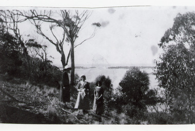
Photograph, 1920c
... Waterways ...Black and white photograph showing three women at viewing site Kalimna of the Entrance to Bass Strait from the Gippsland Lakeswaterways, topography, people -
 Lakes Entrance Regional Historical Society (operating as Lakes Entrance History Centre & Museum)
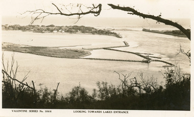
Postcard - Bullock Island
... Waterways ...Black and white postcard of west end of Bullock Island, showing rock groynes around island, wooden entrance piers in entrance to Gippsland Lakes from Bass Strait, sand dunes showing New Works houses and sheds. A tree branch across top and foreground shrubbery. Lakes Entrance VictoriaLooking towards Lakes Entrance (on front)islands, waterways, room display -
 Lakes Entrance Regional Historical Society (operating as Lakes Entrance History Centre & Museum)
Photograph - Bullock Island, Silver Reflections Studio, 1920c
... Waterways ...Black and white photograph showing Bullock Island, Entrance to Bass Strait, buildings on sand dunes, yacht sailing on Cunninghame Arm, tourist launch in foreground, rock groynes around west end of Bullock Island. Lakes Entrance Victoriawaterways, room display, islands -
 Lakes Entrance Regional Historical Society (operating as Lakes Entrance History Centre & Museum)
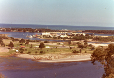
Photograph - Bullock Island, Holding George, 1975c
... Waterways ...Colour photograph of Bullock Island showing Pecks fish processing factory Lakes Entrance Fishing Co-Operative, and PWD buildings, vehicles on picnic area of Marine Parade during one and only offshore power boat race. Spit opposite Club Hotel has grass and some bushes. Lakes Entrance Victoriaislands, land reclamation, waterways -
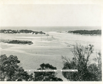
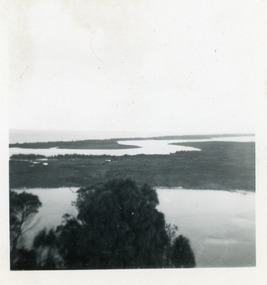
 Lakes Entrance Regional Historical Society (operating as Lakes Entrance History Centre & Museum)
Photograph - Lakes Entrance, Nelson Joan, 1975c
... Waterways ...Colour photograph of the township, taken from Jemmys Point. It shows the causeway and raised bridge to Bullock Island, scrub covered sand hummocks and Bass Strait in distance. Lakes Entrance Victoria waterways, topography, township -
 Lakes Entrance Regional Historical Society (operating as Lakes Entrance History Centre & Museum)
Photograph - Bullock Island, Holding George, 1975c
... Waterways ...Colour photograph of the western end of Bullock Island. It shows two vessels on the North Arm, fishing vessel entering Cunninghame Arm, Pecks factory and other buildings on Bullock Island. Lakes Entrance Victoriawaterways, islands, land reclamation -
 Lakes Entrance Regional Historical Society (operating as Lakes Entrance History Centre & Museum)
Photograph - The Entrance, 1995c
... Waterways ...Second colour copy as 01601-1 portrait size 15 x 10Colour photograph of the entrance from Bass Strait to the Gippsland Lakes. It shows buildings on Bullock Island including Peck's factory. Western end of Bullock Island and area below Jemmys Point, both made during dredging operations over many years. Two fishing boats in entrance. Lakes Entrance Victoria room display, waterways, topography -
 Lakes Entrance Regional Historical Society (operating as Lakes Entrance History Centre & Museum)
Photograph - Reeves Channel, 1915c
... Waterways ...Original in possession of descendant of Arthur Seagrove, teacher at Johnsonville School 1920c.Black and white photograph of Reeves Channel, Gippsland Lakes, showing a launch in the Narrows below Jemmys Point, Rigby Island and a distant view of Fraser Island and Flannagan Island opposite the steep cliffs of the mainland shore. Lakes Entrance Victoria'To Rit with love from Arthur' on backislands, waterways, topography -
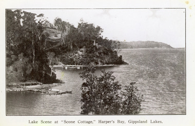 Lakes Entrance Regional Historical Society (operating as Lakes Entrance History Centre & Museum)
Photograph - Scone Cottage, 1920c
... Waterways ...Copied from a postcardBlack and white photograph of Harpers Bight, Gippsland Lakes. It shows rustic jetty in foreground with boat moored, jetty below zigzag pathway to Cliff Crest Tea Rooms, a popular tourist venue, run by Mrs Westerson. Distant view of Jemmys Point. Lakes Entrance VictoriaLakes Scene at Scone Cottage, Harpers Bay, Gippsland Lakes tearoom, tourism, waterways -
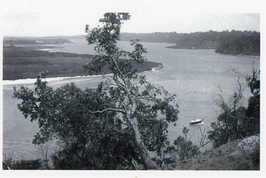
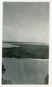
 Lakes Entrance Regional Historical Society (operating as Lakes Entrance History Centre & Museum)
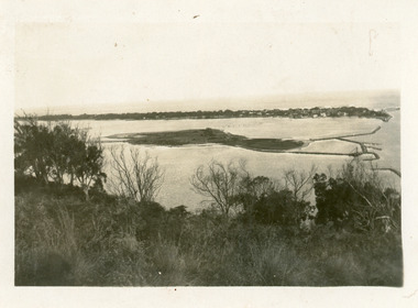
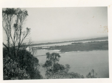
Photograph - Rigby Island, 1950c
... Waterways ...Two other copies 6 x 9 (one - slightly different view)Small format photograph of view from Kalimna across Rigby Island to back lakes near Lakes Entrance, Victoriaislands, waterways, topography -
 Lakes Entrance Regional Historical Society (operating as Lakes Entrance History Centre & Museum)
Photograph - Rigby Island, 1950c
... Waterways ...Black and white photograph of view from Kalimna across Rigby Island to back lakes near Lakes Entrance, Victoriaislands, waterways, topography -
 Lakes Entrance Regional Historical Society (operating as Lakes Entrance History Centre & Museum)
Photograph - Rigby Island, 1950c
... Waterways ...Two other copies 6 x 9 (one - slightly different view)Small format photograph of view from Kalimna across Rigby Island to back lakes near Lakes Entrance, Victoriaislands, waterways, topography -
 Lakes Entrance Regional Historical Society (operating as Lakes Entrance History Centre & Museum)
Photograph - Rigby Island, 1950c
... Waterways ...Two other copies 6 x 9 (one - slightly different view)Small format photograph of view from Kalimna across Rigby Island to back lakes near Lakes Entrance, Victoriaislands, waterways, topography -
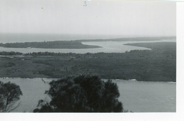
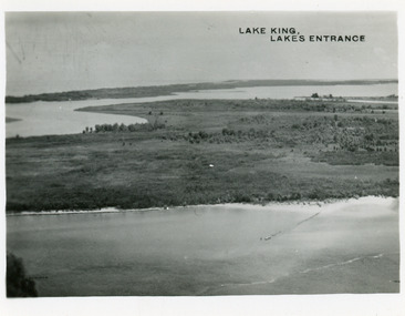 Lakes Entrance Regional Historical Society (operating as Lakes Entrance History Centre & Museum)
Postcard - Lake King, Bulmer H D, 1950c
... Waterways ...Two other copies same sizeBlack and white small format postcard showing part of Rigby Island, Reeves Channel, Hopetoun Channel, The Barrier, on Gippsland Lakes, Victoria, showing foreground bushes, and Bass Strait in distance.Lake King Lakes Entranceislands, waterways, topography -
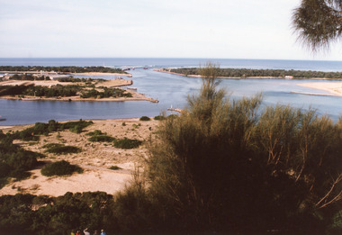
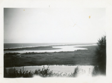
 Lakes Entrance Regional Historical Society (operating as Lakes Entrance History Centre & Museum)
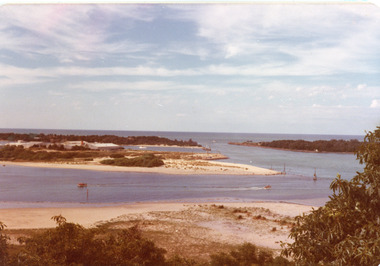
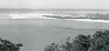
Photograph - Snake Island, 1950c
... Waterways ...Also two other copies 7 x 11Black and white photograph showing eastern end of Rigby Island, Snake Island, and dunes at Lakes Entrance, Victoria. Reeves River below, foreground bushes, Hopetoun Channel in middle distance, Bass Strait in distance. waterways, topography, islands -
 Lakes Entrance Regional Historical Society (operating as Lakes Entrance History Centre & Museum)
Photograph - Rigby Island, 1955c
... Waterways ...Black and white photograph showing east end of Rigby Island, sand build up on Snake Island and rock groynes at Lakes Entrance, Victoria. Shrubbery in foreground, rock groynes in Reeves Channel, sand dunes in background.waterways, ocean, islands -
 Lakes Entrance Regional Historical Society (operating as Lakes Entrance History Centre & Museum)
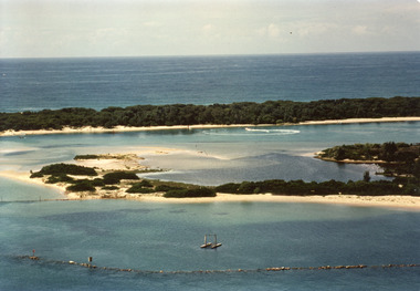
Photograph - Snake Island, 1990c
... Waterways ...This is the before paired photograph used in the 150 year, Lakes Entrance 1858-2008 display.|The after paired photograph number is 01666.1|Also one 12 x 16 framed photograph used in room display.Colour photograph showing sand dunes, Snake Island and rock groynes, Lakes Entrance, Victoria.waterways, islands, vegetation -
 Lakes Entrance Regional Historical Society (operating as Lakes Entrance History Centre & Museum)
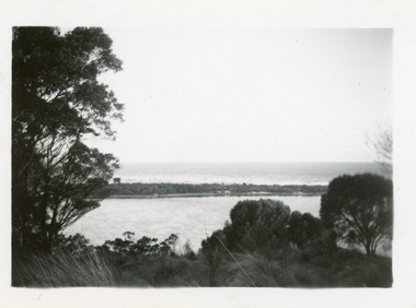
Photograph - Hopetoun Channel, 1950c
... Waterways ...Black and white photograph showing sand dunes and Hopetoun Channel, Lakes Entrance, Victoria. Sand dunes near entrance Western Pier, hidden by trees. Schnapper Cottage just visible on shore. Bass Strait beyond dunes, trees and shrubbery in foreground Jemmys Point. Lakes Entrance Victoriaislands, topography, waterways -
 Lakes Entrance Regional Historical Society (operating as Lakes Entrance History Centre & Museum)
Photograph, 2008
... Waterways ...Date made August 2008Colour photograph showing eastern end of Rigby Island, Snake Island, Reeves Channel in the foreground, Hopetoun Channel with a house and jetty with boats moored. Ocean in the background. Lakes Entrance Victoriawaterways, islands, vegetation