Showing 22332 items matching "will park"
-
 Lakes Entrance Historical Society
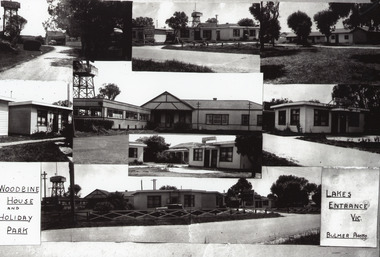
Photograph - Woodbine House and Park, Bulmer H D, 1950c
Black and white photograph collage of different views of Woodbine House, showing weatherboard buildings and water tower, lawns and large trees, ornate fencing. Lakes Entrance VictoriaWoodbine House and Holiday Park Lakes Entrance Victoriaguesthouses, architecture, fences -
 Port Melbourne Historical & Preservation Society
Photograph - Friends of the Park float, Port Melbourne Festival, Pat Grainger, Feb 1989
This float was created by members of Friends of the Park, a group formed in 1987 against government proposals to turn the railway and reservation into a grand boulevard to service the proposed Sandridge City 'bayside' development. Members worked for months to make the decorations, added to a trailer. During the festival procession sausages were BBQ'd on the trailer and handed out to the crowd. On arrival at Murphy's Reserve all floats were put out of sight, and few saw the results of their efforts.One of 16 photos of Friends of the Park float for the February 1989 Port Melbourne Festival: Float construction at Station Street carport, 88 Ingles Street: ?, Gary Ways (L), Amelia Finch (C), Anne Callaghan(R)celebrations fetes and exhibitions, public action campaigns, anne callaghan, gary, amelia finch, friends of the park, port melbourne festival -
 Bendigo Historical Society Inc.
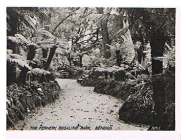
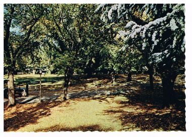
Photograph - FERNERY, ROSALIND PARK, BENDIGO
Photograph, black and white. Image shows the Fernery, Rosalind Park. Tree ferns, rock bordered pathway. On bottom : The Fernery, Rosalind Park, Bendigo, No. 11'cottage, miners -
 Bendigo Historical Society Inc.
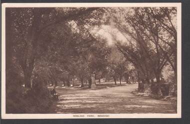
Postcard - ROSALIND PARK BENDIGO
sepia colour card: image shows walkway edged with trees in Rosalind Park. On bottom of card ' Roslind (sic) Park, Bendigo ' No maker printed on back.bendigo, parks and gardens, rosalind park, rosalind park -
 Wangaratta Urban Fire Brigade
photograph
colour photograph of members and families having a picnic .3 Joan Rosser in centre (white skirt, blue top)4 x colour photographs of members and families having a picnic in what looks like Merriwa Park (the park below and behind the Ely St Station) No.7 in a circle - centre(.1) (social committee) in a circle - below the above(.2) .4 Allan Mills cooking the bbqjoan rosser, allan mills, 1970 -
Kew Historical Society Inc
Archive (series) - Subject File, Action Groups [General], 1993
Various PartiesReference, Research, InformationKHS OrderReference file containing sundry newspaper articles and correspondence relating to action groups established to protect Victoria Park, High Street, and Willsmere-Chandler Park.mcdonald’s restaurant, skateboard park, victoria park, victoria park heritage group, willsmere-chandler parkmcdonald’s restaurant, skateboard park, victoria park, victoria park heritage group, willsmere-chandler park -
 Kew Historical Society Inc
Plan, Studley Heights Estate, 1936
Pru Sanderson, in her groundbreaking ‘City of Kew Urban Conservation Study : Volume 2 - Development History’ (1988), summarised the periods of urban development and subdivisions of land in Kew. The periods that she identified included 1845-1880, 1880-1893, 1893-1921, 1921-1933, 1933-1943, and Post-War Development. These periods were selected as they represented periods of rapid growth or decline in urban development. An obvious starting point for Sanderson’s groupings involved population growth and the associated economic cycles. These cycles also highlighted urban expansion onto land that was predominantly rural, although in other cases it represented the decline and breakup of large estates. A number of the plans in the Kew Historical Society’s collection can also be found in other collections, such as those of the State Library of Victoria and the Boroondara Library Service. A number are however unique to the collection.Subdivision plans are historically important documents used as evidence of the growth of suburbs in Australia. They frequently provide information about when the land was sold on which a built structure was subsequently constructed as well as evidence relating to surveyors and real estate and financial agents. The numerous subdivision plans in the Kew Historical Society's collection represent working documents, ranging from the initial sketches made in planning a subdivision to printed plans on which auctioneers or agents listed the prices for which individual lots were sold. In a number of cases, the reverse of a subdivision plan in the collection includes a photograph of a house that was also for sale by the agent. These photographs provide significant heritage information relating house design and decoration, fencing and household gardens.The ‘Studley Heights Estate’ on the South Side of Studley Park Road was launched in 1936. The seventeen allotments in the subdivision fronted Hyton Crescent and Studley Park Road.subdivision plans - kew, studley heights estate -
 Kiewa Valley Historical Society
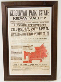
Poster - Framed - Kergunyah
in 1922 Kergunyah Park homestead was built by David Wallace in the late 1800's and remained in the family until the sale in 1922 when it was bought by John Woodside (grandfather of Ewen Wallace) whose family retained it until 1938. Another family named Wallace bought the property in 1938 and this family's descendants are still running it in 2005.David and Henrietta Wallace purchased the original holding and built Kergunyah Park homestead in the late 1800's running cattle on the property. They arrived in Australia in 1867 with their 3 children and were early settlers in the district. Their descendants still live in the district. Their family demonstrates how properties were passed on to the next generation. The poster is an example of the advertising of the sale of land in 1922, the size of land & blocks and the conditions of sale at the time.Large cloth map mounted under glass with a brown wooden frame. Brown writing detailing Kergunyah Park 1923 Sale Record. Includes 4 rectangular brown and white photos and a red map showing 13 blocks of land. Has hanging wire attached on the back."Framed by / Clarkson Collection / Ph; 02 6059 6800"kergunyah. kiewa valley. kergunyah park homestead. ewen wallace. john woodside. -
Darebin Parklands Association
Interview by Reg Johnstone of Laurence J. Course, 5th November 1976, Laurie Course, 1976
Audio recordings, including a recording of a radio interview (approximately 12 minutes) in which Laurie Course discusses the early history of the Rockbeare Park; the significance of the area; and plans to develop the area into the Darebin Parklands.Audio tape. This item and all other Darebin Parklands Association archival material is now held by State Library Victoria (Accession No: YMS 13746). Please contact State Library Victoria if access is required.Covered with cardboard sleeve wth annotation that incluces: [Interview by Reg Johnstone of Laurence J. Course of the Rockbeare Park Conservation Group at 1.30 in the Hardware Lane Studio in Cyclone House & was broadcast on 3ZZ at 8.15 that night on Friday 5th November 1976]. Annotations also on tape itself. -
Lakes Entrance Historical Society
Photograph - Koori Sport and Recreation Group, 1/04/1995 12:00:00 AM
Koori Sport and Recreation Group Donna Clulow Liaison Officer LESC, Maurice Buddy Gordon, Nick Moffat, Rosalyn Chester Lakes Entrance Victoria. Also a black and white photograph of a group of children playing cricket possibly Eatern Beach Picnic Park number 04121.1Black and white photograph of Koori Sport and Recreation Group Donna Clulow Liaison Officer LESC, Maurice Buddy Gordon, Nick Moffat, Rosalyn Chester Lakes Entrance Victoria. Also a black and white photograph of a group of children playing cricket possibly Eatern Beach Picnic Park number 04121.1aboriginals, sports, recreation -
 Whitehorse Historical Society Inc.
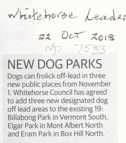
Article, New Dog Parks
Dogs can frolic off-lead in three new public places from 1 Nov 2018 bring the total to 22 places.Dogs can frolic off-lead in three new public places from 1 Nov 2018 bring the total to 22 places. The three new ones are Billabong Park, South Vermont; Elgar Park, Mont Albert & Erarn Park, Box Hill North.Dogs can frolic off-lead in three new public places from 1 Nov 2018 bring the total to 22 places. dogs, city of whitehorse, billabong park, vermont south -
 Melbourne Tram Museum
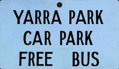
Sign, The Met, "Yarra Park Car Park Free Bus", c1980?
Sign - metal sheet black letters with a light blue background with the words "Yarra Park Car Park Free Bus" Has a hole centrally along the top edge. Donor advised used on buses that ran from the city to Yarra Park possibly during an event.trams, tramways, yarra park, buses, melbourne -
 Bendigo Historical Society Inc.
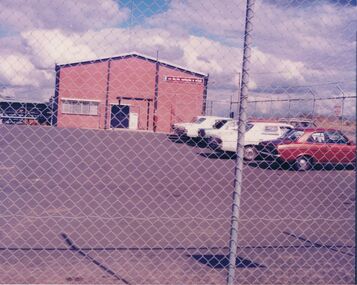
Photograph - CASTLEMAINE GAS COMPANY COLLECTION: PHOTO GAS AND FUEL SITE
Brick building with a sign ''Gas and fuel corporation of Victoria '' a car park with 6 cars parked. The photo was taken from outside a fence. Date and location unknown.business, retail, gas and fuel -
 Bendigo Historical Society Inc.
Postcard - ROSALIND PARK
Postcard: Image shows view of trees in Rosalind Park. On LH side of pathwasy, man with tractor. On back ' Bendigo, Victoria, pleasant autumn setting in Rosalind Park'Nu Color Vue, BE 33, Copyrightbendigo, parks and gardens, rosalind park, bendigo, rosalind park -
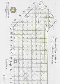 Bendigo Historical Society Inc.
Map - FRIENDS OF WHITE HILLS CEMETERY COLLECTION: TWO MAPS
Maps. Two maps of Bendigo Cemetery. (a) Bendigo Cemetery produced by Bendigo Cemeteries Trust. (b) Bendigo Remembrance Park produced by Remembrance Parks Central Victoria.map, bendigo, bendigo cemetery and remembrance park -
 Stawell Historical Society Inc
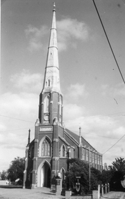
Photograph, St. Matthew’s Presbyterian Church with Uniting Church sign on left - 3 Photos
Three black and white photos St. Matthew’s Church Stawell. Two of the photos are identical showing a Holden & Hilman cars parked out the front with a group of people at the entrance to the church. A flag is flying to the right in the photograph. The second photo similar view with no people or cars outside with a United Church sign on the right. Photo taken after 1977 which saw changes to Uniting Church.Three black & white photos of St. Matthew's Church. Two of the photos are identical showing a Holden & Hilman cars parked out the front with a group of people at the entrance to the church. A flag is flying to the right in the photograph, The second photo similar view with no people or cars outside.stawell religion -
 Stawell Historical Society Inc
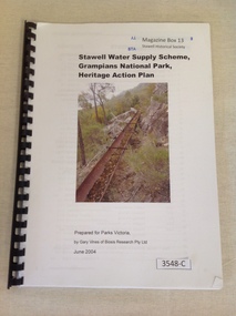
Book, Gary Vines, Stawell Water Supply Scheme, Grampians National Park, Heritage Action Plan, 2004
White paper with black print and colour photo of a water race. this book has a black plastic bindingStawell Water Supply Scheme, Grampians National Park, Heritage Action Plan. Prepared for Parks Victoria, by Gary Vines of Biosis Research Pty Ltdstawell -
 Mt Dandenong & District Historical Society Inc.
Photograph
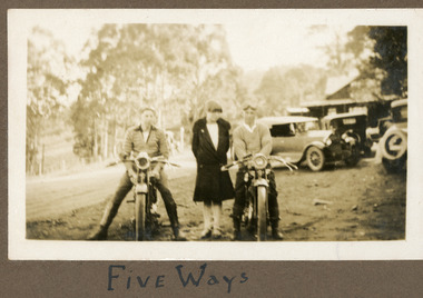
The men on the motorbikes have goggles on their heads but no helmets. They are parked at the Five Ways intersection at Kalorama. The building behind them is the FiveWays Cafe. The image is from the album of Ivy Child and would be late 1920s. Ivy May Child (1910 – 1989) was the daughter of Arthur Edward (Ted) Child (1878 – 1964) and Ethel May Madden (1888 – 1970). Ted Child was the son of Matthew Francis Child (1839 – 1933) and Martha Jeeves (1857 – 1926). He was the grandson of one of the early pioneers Francis Child. Ivy grew up on the family property on Childs Road and took many photographs. Most of these are glued into her photo album. The album covered the years from c1927 – 1932. Ivy married Henry William Burgess (1906 – 1968) in 1944. The photographs remain in their original state in the album with individual copies made. Sepia coloured photograph showing two men on motorcycles parked with a woman standing between them. Three old cars, a building, road and trees are visible behind them.Written below photograph in album: FIVE WAYSmotorcycle, motorbike, fiveways, five ways, fiveways cafe -
 Glen Eira Historical Society
Caulfield Park playground
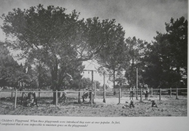
Photograph of childrens playground in Caulfield Park, date unknowncaulfield north, caulfield park, parks, playgrounds -
 Glen Eira Historical Society
Park Street Elsternwick
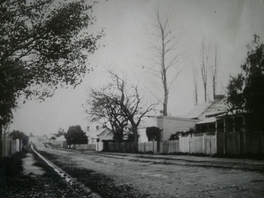
Photograph of Park Street Elsternwick 27 May 1900elsternwick, park street -
Federation University Historical Collection
Photograph, Launch of the State Revenue Office on the Ballarat Technology Park
Launch of the State Revenue Office at the Ballarat Technology Park.state revenue office, ballarat technology park, irrr, begonia festival -
 Mission to Seafarers Victoria
Photograph - Photograph, Sepia, Mr and Mrs Gurney Goldsmith, Disabled French Barque: Towing up the Yarra from Monomeith Gardens Newport, 1906
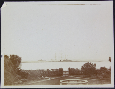
Monomeith was the house of Major and Mrs A. Morton Begg, located 67 the Strand, in Newport (housing the Westbourne Grammar School, Williamstown Campus, since it was leased from the Harbour Trust in 1956 then purchased by the school in 1972)Small monochrome photograph, view of ships from a parkHandwritten in pencil on verso: 83 (?) and a 3 in bottom right cornermonomeith, newport, morton begg, french, barque, towing, yarra river -
Glenelg Shire Council Cultural Collection
Photograph - Photograph - Casterton, Victoria, c. 1963
SOURCED FROM CASTERTON TOWN HALL (FORMER SHIRE OF GLENELG)Black and white photo. Island Park Casterton, Victoria.Back: Black stamp '063826'casterton, tourism -
Glenelg Shire Council Cultural Collection
Photograph - Photograph - Casterton, Victoria, c. 1963
SOURCED FROM CASTERTON TOWN HALL (FORMER SHIRE OF GLENELG)Black and white photo. Island Park Oval, CastertonBack: Black stamp '003826casterton, island park oval, sport, recreation -
 Eltham District Historical Society Inc
Photograph, Montmorency RSL, Petrie Park, Montmorency
Colour photo of Montmorency RSL building, Petrie Parkrsl, returned services league, montmorency, petrie park -
Eltham District Historical Society Inc
Folder, A.B. Blair
Folder of information on A B Blair, Kinglake National Parka.b blair -
Victoria Police Museum
Photograph (police car)
Valiants, Fords and Cortinas parked in a garage. Circa 1967police vehicles; motor transport branch; motor transport section; wireless patrol; valiant car; ford car; cortina car -
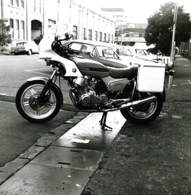 Victoria Police Museum
Photograph (police motorcycle)
Honda CB 900 parked on the street. Circa 1980.police vehicles; wireless patrol; motor transport branch; motor transport section; police motorcycles; honda motorcycle -
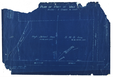 Federation University Historical Collection
Plan, Plan of Part of Vale Park, 1928, 15/1928
Probably the Ballarat School of Mines Farm or pine plantation.Ballarat Techncial School Norman StreetBlue line plan of part of Vale Park, Ballarat. vale park, ballarat school of mines, ballarat school of mines farm, ballarat high school, norman street -
Running Rabbits Military Museum operated by the Upwey Belgrave RSL Sub Branch
Menu
113 Independant Brigade Group (Ordanance Field Park)documents, 1942, army