Showing 1617 items matching "zones"
-
 National Vietnam Veterans Museum (NVVM)
Photograph, Gibbons, Denis, Quartermasters Store 1
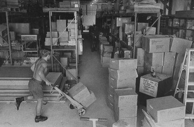
Denis Gibbons (1937 – 2011) Trained with the Australian Army, before travelling to Vietnam in January 1966, Denis stayed with the 1st Australian Task Force in Nui Dat working as a photographer. For almost five years Gibbons toured with nine Australian infantry battalions, posting compelling war images from within many combat zones before being flown out in late November 1970 after sustaining injuries. The images held within the National Vietnam Veterans Museum make up the Gibbons Collection.A black and white photograph of Diggers in the Quartermasters Store at 1st Australian Field Hospital, Vung Tau, South Vietnam sort and transport stores to their respective shelf area ready for stacking. photograph, 1st australian field hospital, vung tau, quartermasters store, gibbons collection catalogue, diggers, denis gibbons -
 National Vietnam Veterans Museum (NVVM)
Photograph, Gibbons, Denis, Checking the Empty Triage
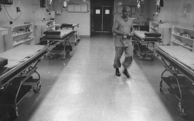
Denis Gibbons (1937 – 2011) Trained with the Australian Army, before travelling to Vietnam in January 1966, Denis stayed with the 1st Australian Task Force in Nui Dat working as a photographer. For almost five years Gibbons toured with nine Australian infantry battalions, posting compelling war images from within many combat zones before being flown out in late November 1970 after sustaining injuries. The images held within the National Vietnam Veterans Museum make up the Gibbons Collection.A black and white photogaph of Medic Cpl Peter Whittle at the1st Australian Field Hospital, Vung Tau, South Vietnam, checking the empty triage to see that all is in readiness for incoming casualties. The triage bays were always at peak readiness, 24 hours a day.photograph, 1st australian field hospital, vung tau, medic, cpl peter whittle, gibbons collection catalogue, triage, denis gibbons -
 National Vietnam Veterans Museum (NVVM)
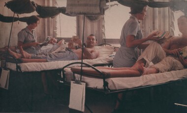
Photograph, Gibbons, Denis, Medivac Day
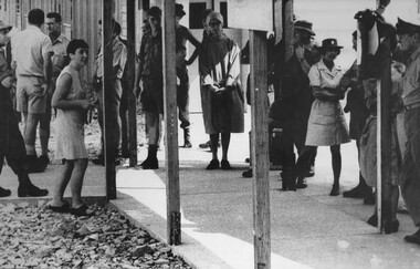
Denis Gibbons (1937 – 2011) Trained with the Australian Army, before travelling to Vietnam in January 1966, Denis stayed with the 1st Australian Task Force in Nui Dat working as a photographer. For almost five years Gibbons toured with nine Australian infantry battalions, posting compelling war images from within many combat zones before being flown out in late November 1970 after sustaining injuries. The images held within the National Vietnam Veterans Museum make up the Gibbons Collection. A black and white photograph of Medivac Day at the 1st Australian Field Hospital, Vung Tau, South Vietnam, hospital staff, females from left, Lt Ruth Page, Capt June Minchow and Dr Shirley Coughlan wait to say farewell to the boys returningto Australia on the RAAF C130 flight.photograph, 1st australian field hospital, vung tau, lt ruth page, capt june minchow, dr shirley coughlan, raaf, c130 medivac flight, gibbons collection catalogue, denis gibbons -
 National Vietnam Veterans Museum (NVVM)
Photograph, Gibbons, Denis, Military Medal
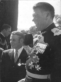
Denis Gibbons (1937 – 2011) Trained with the Australian Army, before travelling to Vietnam in January 1966, Denis stayed with the 1st Australian Task Force in Nui Dat working as a photographer. For almost five years Gibbons toured with nine Australian infantry battalions, posting compelling war images from within many combat zones before being flown out in late November 1970 after sustaining injuries. The images held within the National Vietnam Veterans Museum make up the Gibbons Collection. A black and white photograph of a Medic with the Governor of NSW, Sir Roden Cutler VC after receiving his Military Medal at a cermony Government House NSW in 1971. The award was made for bravery while serving as a medic on a US dustoff helicopter.photograph, 1st australian field hospital, medic, sir roden cutler vc, military medal, dustoff helicopter, gibbons collection catalogue -
 National Vietnam Veterans Museum (NVVM)
Photograph, Gibbons, Denis, Nurses Visit 1st ATF Base
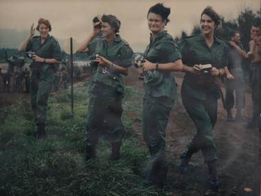
Denis Gibbons (1937 – 2011) Trained with the Australian Army, before travelling to Vietnam in January 1966, Denis stayed with the 1st Australian Task Force in Nui Dat working as a photographer. For almost five years Gibbons toured with nine Australian infantry battalions, posting compelling war images from within many combat zones before being flown out in late November 1970 after sustaining injuries. The images held within the National Vietnam Veterans Museum make up the Gibbons Collection. A coloured photograph of Lt Margaret Ahern, Captain Amy Pittendreigh, Lt Colleen Mealey and Lt Terrie Roche, nursing sisters from the 8th Field Ambulance Hospital, Vung Tau, watch of 2 RAR leave on a heliborn assault from Luscombe field at the 1st Australian Task Force, Nui Dat.photograph, lt margaret ahern, capt amy pittendreigh, lt colleen mealey, lt terrie roche, 8th field ambulance hospital, vung tau, 2 rar, luscombe airfield, 1st australian task force, gibbons collection catalogue, denis gibbons -
 National Vietnam Veterans Museum (NVVM)
Photograph, Gibbons, Denis, Long Steep Stairway
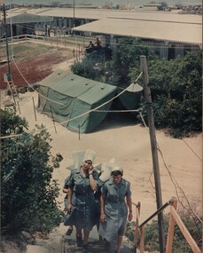
Denis Gibbons (1937 – 2011) Trained with the Australian Army, before travelling to Vietnam in January 1966, Denis stayed with the 1st Australian Task Force in Nui Dat working as a photographer. For almost five years Gibbons toured with nine Australian infantry battalions, posting compelling war images from within many combat zones before being flown out in late November 1970 after sustaining injuries. The images held within the National Vietnam Veterans Museum make up the Gibbons Collection. A coloured photograph of Captain Amy Pittendreigh and Lt Terrie Roche followed by Lt Colleen Mealey and Lt Margaret Ahern, climb the long stairway from the wards at the 8th Field Ambulance Hospital to the Officers Mess, to enjoy a short rest and lunchphotograph, capt amy pittendreigh, lt terrie roche, lt colleen mealey, lt margaret ahern, 8th field ambulance hospital, officers mess, gibbons collection catalogue, denis gibbons -
 National Vietnam Veterans Museum (NVVM)
Photograph, Gibbons, Denis, Lt Terrie Roche
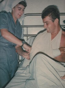
Denis Gibbons (1937 – 2011) Trained with the Australian Army, before travelling to Vietnam in January 1966, Denis stayed with the 1st Australian Task Force in Nui Dat working as a photographer. For almost five years Gibbons toured with nine Australian infantry battalions, posting compelling war images from within many combat zones before being flown out in late November 1970 after sustaining injuries. The images held within the National Vietnam Veterans Museum make up the Gibbons Collection. A colured photograph of Lt Terrie Roche, during ward rounds, changes the dressing on Sapper Bruce Bevan of Mortdale, Sydney, at the 8th Field Ambulance Hospital, Vung Tau, South Vietnam. The treatment varied from ward to ward for wounded and sick diggers.A colured photograph of Lt Terrie Roche, during ward rounds, changes the dressing on Sapper Bruce Bevan of Mortdale, Sydney, at the 8th Field Ambulance Hospital, Vung Tau, South Vietnam. The treatment varied from ward to ward for wounded and sick diggers.photograph, 8th field ambulance hospital, vung tau, lt terrie roach, sapper bruce bevan, digger, gibbons collection catalogue, wounded serviceman, denis gibbons -
 National Vietnam Veterans Museum (NVVM)
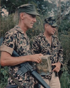
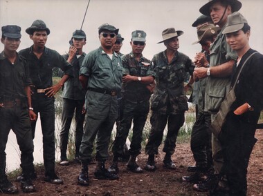
Photograph, Gibbons, Denis, Mekong Delta Operations
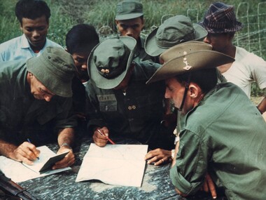
Denis Gibbons (1937 – 2011) Trained with the Australian Army, before travelling to Vietnam in January 1966, Denis stayed with the 1st Australian Task Force in Nui Dat working as a photographer. For almost five years Gibbons toured with nine Australian infantry battalions, posting compelling war images from within many combat zones before being flown out in late November 1970 after sustaining injuries. The images held within the National Vietnam Veterans Museum make up the Gibbons Collection. A colour photograph of two members of the Australian Army Training Team Vietnam (AATTV) operating with the Army Of The Republic Of Vietnam (ARVN), as they check map references and other intelligence information with an ARVN Officer prior to commencing operations in the Mekong Delta of IV Corps.photograph, aattv, mekong delta, army of the republic of north vietnam (arvn), iv corps, gibbons collection catalogue, denis gibbons, photographer, vietnam war, australian army training team vietnam (aattv), intelligence information -
 National Vietnam Veterans Museum (NVVM)
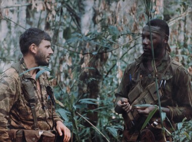
Photograph, Gibbons, Denis, Montagnard 2
Denis Gibbons (1937 – 2011) Trained with the Australian Army, before travelling to Vietnam in January 1966, Denis stayed with the 1st Australian Task Force in Nui Dat working as a photographer. For almost five years Gibbons toured with nine Australian infantry battalions, posting compelling war images from within many combat zones before being flown out in late November 1970 after sustaining injuries. The images held within the National Vietnam Veterans Museum make up the Gibbons Collection. A colour photograph of a member of the Australian Army Training Team Vietnam (AATTV) discussing operational problems with one of his American counterparts, while leading a Mike Force Battalion of Montagnards, in the thick jungle on the Cambodian border of 2 Corps.photograph, aattv, mike force, 2 corps, montagnard mike force, gibbons collection catalogue, denis gibbons, photographer, vietnam war, australian army training team vietnam (aattv), mike force battalion of montagnards, cambodian border -
 National Vietnam Veterans Museum (NVVM)
Photograph, Gibbons, Denis, Regional Force Unit
Denis Gibbons (1937 – 2011) Trained with the Australian Army, before travelling to Vietnam in January 1966, Denis stayed with the 1st Australian Task Force in Nui Dat working as a photographer. For almost five years Gibbons toured with nine Australian infantry battalions, posting compelling war images from within many combat zones before being flown out in late November 1970 after sustaining injuries. The images held within the National Vietnam Veterans Museum make up the Gibbons Collection A colour photograph of two members of the Australian Army Taining Team Vietnam (AATTV) operating with a local Vietnamese Regional Force Unit in the Mekong Delta of IV Corps. Regional Force Units were responsible for local village and infrastructure protection.photograph, aattv, mekong delta, vietnamese regional force unit, gibbons collection catalogue, denis gibbons, photographer, vietnam war, iv corps, australian army training team vietnam (aattv) -
 National Vietnam Veterans Museum (NVVM)
Photograph, Gibbons, Denis, Lac Thien
Denis Gibbons (1937 – 2011) Trained with the Australian Army, before travelling to Vietnam in January 1966, Denis stayed with the 1st Australian Task Force in Nui Dat working as a photographer. For almost five years Gibbons toured with nine Australian infantry battalions, posting compelling war images from within many combat zones before being flown out in late November 1970 after sustaining injuries. The images held within the National Vietnam Veterans Museum make up the Gibbons Collection. A colour photograph of Capt Len Opie and WO1 Bill Birkett, of the Australian Army Training Team Vietnam (AATTV), at the special forces camp at Lake Lac Thien where they are working with Rhade, M'nong, Muong and Sedang Montagnards.photograph, aattv, capt len opie, wo1 bill birkett, lake lac thien, sedang montagnards, gibbons collection catalogue, denis gibbons, photographer, vietnam war, australian army training team vietnam (aattv), rhade montagnards, m'nong montagnards, muong montagnards -
 National Vietnam Veterans Museum (NVVM)
Photograph, Gibbons, Denis, Red Cross Girls 1
Denis Gibbons (1937 – 2011) Trained with the Australian Army, before travelling to Vietnam in January 1966, Denis stayed with the 1st Australian Task Force in Nui Dat working as a photographer. For almost five years Gibbons toured with nine Australian infantry battalions, posting compelling war images from within many combat zones before being flown out in late November 1970 after sustaining injuries. The images held within the National Vietnam Veterans Museum make up the Gibbons Collection. A colour photograph of 8 Field Ambulance Hospital Red Cross nurses, Janice Webb and Jean Debelle, doing the rounds with the wounded and sick Diggers.photograph, 8 field ambulance hospital, hospital, red cross, janice webb (red cross), jean debelle (red cross), nurses, gibbons collection catalogue, denis gibbons, photographer, vietnam war, diggers, wounded serviceman -
 National Vietnam Veterans Museum (NVVM)
Photograph, Gibbons, Denis, Pleiku
Denis Gibbons (1937 – 2011) Trained with the Australian Army, before travelling to Vietnam in January 1966, Denis stayed with the 1st Australian Task Force in Nui Dat working as a photographer. For almost five years Gibbons toured with nine Australian infantry battalions, posting compelling war images from within many combat zones before being flown out in late November 1970 after sustaining injuries. The images held within the National Vietnam Veterans Museum make up the Gibbons Collection.A colour photograph of three members of the Australian Army Training Team Vietnam (AATTV) discussing operational requirements with the senior Vietnamese Army Colonel at Pleiku, South Vietnam. The advisers with their American counterparts commanded a Montagnard Mike Force Battalion.A colour photograph of three members of the Australian Army Training Team Vietnam (AATTV) discussing operational requirements with the senior Vietnamese Army Colonel at Pleiku, South Vietnam. The advisers with their American counterparts commanded a Montagnard Mike Force Battalion.photograph, aattv, pleiku, south vietnam, montagnard mike force, gibbons collection catalogue, denis gibbons, photographer, vietnam war, australian army training team vietnam (aattv), vietnamese army colonel -
 National Vietnam Veterans Museum (NVVM)
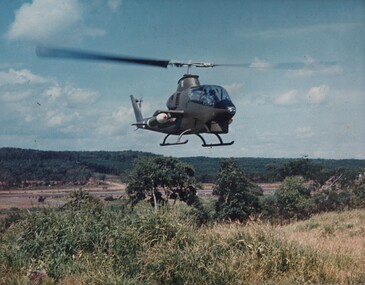
Photograph, Gibbons, Denis, Bell AH-1G Hueycobra
Denis Gibbons (1937 – 2011) Trained with the Australian Army, before travelling to Vietnam in January 1966, Denis stayed with the 1st Australian Task Force in Nui Dat working as a photographer. For almost five years Gibbons toured with nine Australian infantry battalions, posting compelling war images from within many combat zones before being flown out in late November 1970 after sustaining injuries. The images held within the National Vietnam Veterans Museum make up the Gibbons Collection. A colour photograph of a Bell AH-1G Huey Cobra from the 1st Platoon 334th Armed Helicopter, lands at the base area of the SAS Regiment, 1st Australian Task Force Base, in Nui Dat, Phuoc Tuy Province Vietnam. The AH-1G Huey Cobra was the most lethal gun platform operating in Vietnam.photograph, 334th armed helicopter coy, bell ah-1g helicopter, 1st atf base, nui dat, phuoc tuy province, huey cobra, gibbons collection catalogue, denis gibbons, photographer, vietnam war, 1st platoon, sas regiment -
 National Vietnam Veterans Museum (NVVM)
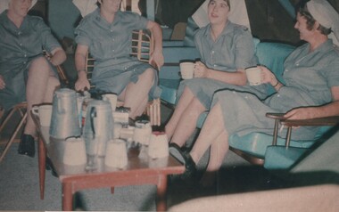
Photograph, Gibbons, Denis, Morning Break
Denis Gibbons (1937 – 2011) Trained with the Australian Army, before travelling to Vietnam in January 1966, Denis stayed with the 1st Australian Task Force in Nui Dat working as a photographer. For almost five years Gibbons toured with nine Australian infantry battalions, posting compelling war images from within many combat zones before being flown out in late November 1970 after sustaining injuries. The images held within the National Vietnam Veterans Museum make up the Gibbons Collection. A colour photograph of a few minutes respite. Lt Margaret Ahern, Lt Colleen Mealey, Lt Terrie Roche, Lt Colleen Mealey and Capt Amy Pittendreigh, relax over coffee at the officers mess during a morning break from the hospital routine.A colour photograph of a few minutes respite. Lt Margaret Ahern, Lt Colleen Mealey, Lt Terrie Roche, Lt Colleen Mealey and Capt Amy Pittendreigh, relax over coffee at the Officers Mess during a morning break from the hospital routine.photograph, nurses - vietnam, lt margaret ahern, lt colleen mealey, lt terrie roach, capt amy pittendreigh, hospital, gibbons collection catalogue, denis gibbons, photographer, vietnam war, officers mess, 8 field ambulance hospital -
 National Vietnam Veterans Museum (NVVM)
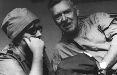
Photograph, Gibbons, Denis, Capt Hall
Denis Gibbons (1937 – 2011) Trained with the Australian Army, before travelling to Vietnam in January 1966, Denis stayed with the 1st Australian Task Force in Nui Dat working as a photographer. For almost five years Gibbons toured with nine Australian infantry battalions, posting compelling war images from within many combat zones before being flown out in late November 1970 after sustaining injuries. The images held within the National Vietnam Veterans Museum make up the Gibbons Collection. A black and white photograph of Nursing Sister, Capt Ann Hall. She is in deep conversation with a patient at the 1st Australian Field Hospital, Vung Tau, South Vietnam, as he waits his turn to be loaded onto a stretcher to be medivaced back to Australia by an RAAF C130 Medivac flight.photograph, capt ann hall, 1st australian field hospital, vung tau, raaf, c130 medivac flight, gibbons collection catalogue, denis gibbons, photographer, vietnam war, nurses, australian army nurses -
 National Vietnam Veterans Museum (NVVM)
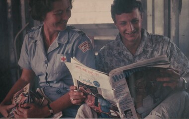
Photograph, Gibbons, Denis, Red Cross Girls 2
Denis Gibbons (1937 – 2011) Trained with the Australian Army, before travelling to Vietnam in January 1966, Denis stayed with the 1st Australian Task Force in Nui Dat working as a photographer. For almost five years Gibbons toured with nine Australian infantry battalions, posting compelling war images from within many combat zones before being flown out in late November 1970 after sustaining injuries. The images held within the National Vietnam Veterans Museum make up the Gibbons Collection. A colour photograph of Pte Peter Lapsco, of Renmark, SA and Red Cross Nurse Janice Webb sharing something highly amusing in Woman's Day during her hospital rounds at the 8 Field Ambulance Hospital, Vung Tau, South Vietnam.photograph, 8 field ambulance hospital, pte peter lapsco, janice webb, red cross nurse, vung tau, gibbons collection catalogue, denis gibbons, photographer, vietnam war, janice webb (red cross), women's day -
 National Vietnam Veterans Museum (NVVM)
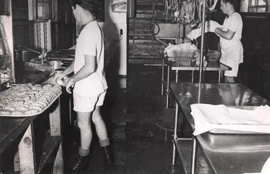
Photograph, Gibbons, Denis, Preparing Evening Meal 1
Denis Gibbons (1937 – 2011) Trained with the Australian Army, before travelling to Vietnam in January 1966, Denis stayed with the 1st Australian Task Force in Nui Dat working as a photographer. For almost five years Gibbons toured with nine Australian infantry battalions, posting compelling war images from within many combat zones before being flown out in late November 1970 after sustaining injuries. The images held within the National Vietnam Veterans Museum make up the Gibbons Collection.A black and white photograph of two cooks from the Royal Australian Catering Corps preparing the evening meal for staff and patients at the 1st Australian Field Hospital, Vung Tau, South Vietnam. Specialist meals were provided for some casualty and medical patients.photograph, 1st australian field hospital, vung tau, royal australian catering corps, gibbons collection catalogue, denis gibbons, photographer, vietnam war, cooks -
 National Vietnam Veterans Museum (NVVM)
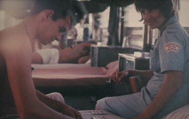
Photograph, Gibbons, Denis, Game of Patience
Denis Gibbons (1937 – 2011) Trained with the Australian Army, before travelling to Vietnam in January 1966, Denis stayed with the 1st Australian Task Force in Nui Dat working as a photographer. For almost five years Gibbons toured with nine Australian infantry battalions, posting compelling war images from within many combat zones before being flown out in late November 1970 after sustaining injuries. The images held within the National Vietnam Veterans Museum make up the Gibbons Collection. A colour photograph of Winsome Ayliffe, stoping during her hospital rounds at the 8 Field Ambulance Hospital, Vung Tau, South Vietnam, to chat with Pte David Jones, of Bunbury WA, who finds a game of 'patience' a way of passing the time.photograph, red cross, 8 field ambulance hospital, winsome ayliffe (red cross), pte david jones, gibbons collection catalogue, denis gibbons, photographer, vietnam war -
 National Vietnam Veterans Museum (NVVM)
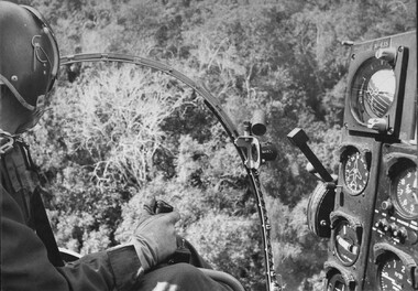
Photograph, Gibbons, Denis, Possum 2
Denis Gibbons (1937 – 2011) Trained with the Australian Army, before travelling to Vietnam in January 1966, Denis stayed with the 1st Australian Task Force in Nui Dat working as a photographer. For almost five years Gibbons toured with nine Australian infantry battalions, posting compelling war images from within many combat zones before being flown out in late November 1970 after sustaining injuries. The images held within the National Vietnam Veterans Museum make up the Gibbons Collection. A black and white photograph of a rotary (helicopter) wing 'Possum' aircraft from 161 (Indep) Recce Flight, stationed at the 1st Australian Task Force Base, Nui Dat, Phuoc Tuy Province, Vietnam. The pilot searches the jungle below, for signs of the elusive NVA/VietCong forces operating in the area.photograph, possum aircraft, 161 recon flt, 1st atf base, nui dat, phuoc tuy province, nva/vc, gibbons collection catalogue, denis gibbons, photographer, vietnam war, 1st australian task force, viet cong -
 National Vietnam Veterans Museum (NVVM)
Photograph, Gibbons, Denis, Lt Col Lloyd
Denis Gibbons (1937 – 2011) Trained with the Australian Army, before travelling to Vietnam in January 1966, Denis stayed with the 1st Australian Task Force in Nui Dat working as a photographer. For almost five years Gibbons toured with nine Australian infantry battalions, posting compelling war images from within many combat zones before being flown out in late November 1970 after sustaining injuries. The images held within the National Vietnam Veterans Museum make up the Gibbons Collection. A black and white photograph of Lac Thien, South Vietnam 1970, where Lt Col Lloyd, Officer Commanding the Australian Army Training Team Vietnam ( AATTV), alights from his personal US Army "slick" helicopter, during a visit to members of "The Team". Here he visited Capt Len Opie and WO1 Bill Birkett.photograph, lac thien, lt col lloyd, helicopter, capt len opie, wo1 bill birkett, gibbons collection catalogue, denis gibbons, photographer, vietnam war, australian army training team vietnam (aattv), us army slick helicopter -
 National Vietnam Veterans Museum (NVVM)
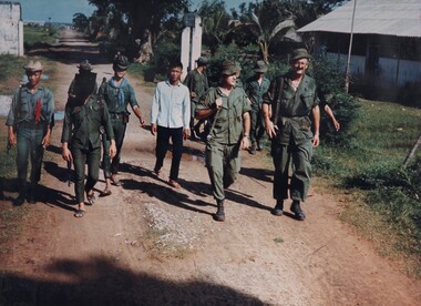
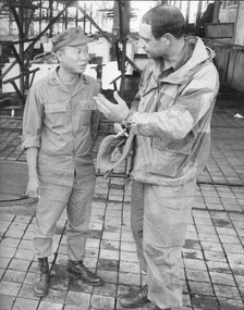
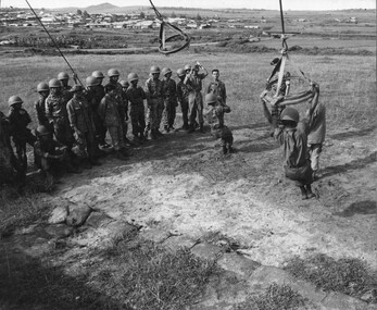
Photograph, Gibbons, Denis, Lt Col Khan
Denis Gibbons (1937 – 2011) Trained with the Australian Army, before travelling to Vietnam in January 1966, Denis stayed with the 1st Australian Task Force in Nui Dat working as a photographer. For almost five years Gibbons toured with nine Australian infantry battalions, posting compelling war images from within many combat zones before being flown out in late November 1970 after sustaining injuries. The images held within the National Vietnam Veterans Museum make up the Gibbons Collection.A black and white photograph of Lt Col Khan CO 5 RAR as he advises the Duc Thanh District Chief Maj Tram Van Ngo that the placement of the dead VietCong bodies around the 'Gallia' rubber plantation was not acceptable to the Australians. 29/12/1969photograph, lt col colin khan, duc thanh district chief, maj tram van ngo, viet cong, rubber plantation gallia, 5 rar, gibbons collection catalogue, denis gibbons, photographer, vietnam war -
 National Vietnam Veterans Museum (NVVM)
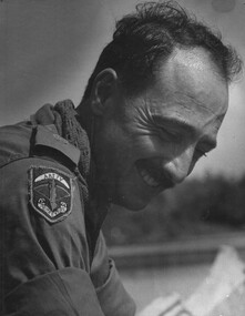
Photograph, Gibbons, Denis, AATTV Major
Denis Gibbons (1937 – 2011) Trained with the Australian Army, before travelling to Vietnam in January 1966, Denis stayed with the 1st Australian Task Force in Nui Dat working as a photographer. For almost five years Gibbons toured with nine Australian infantry battalions, posting compelling war images from within many combat zones before being flown out in late November 1970 after sustaining injuries. The images held within the National Vietnam Veterans Museum make up the Gibbons Collection.A black and white photograph of Hue, 1 Corps, South Vietnam 1969. An Australian Army Training Team Vietnam (AATTV) Major looks relaxed as he is paddled up the Perfume River, by members of his unit stationed North West of Hue.photograph, hue, perfume river, 1 corps, aattv, gibbons collection catalogue, denis gibbons, photographer, vietnam war, australian army training team vietnam (aattv), major -
 National Vietnam Veterans Museum (NVVM)
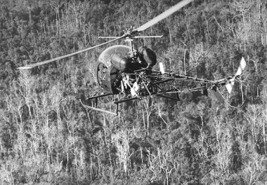
Photograph, Gibbons, Denis, Possum 1
Denis Gibbons (1937 – 2011) Trained with the Australian Army, before travelling to Vietnam in January 1966, Denis stayed with the 1st Australian Task Force in Nui Dat working as a photographer. For almost five years Gibbons toured with nine Australian infantry battalions, posting compelling war images from within many combat zones before being flown out in late November 1970 after sustaining injuries. The images held within the National Vietnam Veterans Museum make up the Gibbons Collection.A black and white photograph of a rotary (helicopter) wing pilot and his 'Possum' aircraft, swooping low over the jungle of Phuoc Tuy Province, South Vietnam, in search of a very elusive NVA/VietCong enemy. These unarmed aircraft were part of the eyes of the Australina Task Force.photograph, helicopter, possum aircraft, jungle, phuoc tuy province, south vietnam, nva/vc, gibbons collection catalogue, denis gibbons, photographer, vietnam war, viet cong, australian task force -
 National Vietnam Veterans Museum (NVVM)
Photograph, Gibbons, Denis, Parachute Training
Denis Gibbons (1937 – 2011) Trained with the Australian Army, before travelling to Vietnam in January 1966, Denis stayed with the 1st Australian Task Force in Nui Dat working as a photographer. For almost five years Gibbons toured with nine Australian infantry battalions, posting compelling war images from within many combat zones before being flown out in late November 1970 after sustaining injuries. The images held within the National Vietnam Veterans Museum make up the Gibbons Collection. A black and white photograph of an Australina Army Training Team (AATTV) advisor at the Vietnamese Ranger, Parachute Training Establishment, Bear Cat, 3 Corps, watching Vietnamese ranger recruits practice the correct way to roll when landing from a parachute jump.photograph, aattv, vietnamese ranger, parachute training establishment, bear cat, 3 corps, gibbons collection catalogue, denis gibbons, photographer, vietnam war, australian army training team vietnam (aattv) -
 National Vietnam Veterans Museum (NVVM)
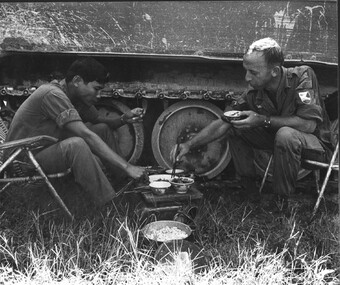
Photograph, Gibbons, Denis, Sharing a Meal
Denis Gibbons (1937 – 2011) Trained with the Australian Army, before travelling to Vietnam in January 1966, Denis stayed with the 1st Australian Task Force in Nui Dat working as a photographer. For almost five years Gibbons toured with nine Australian infantry battalions, posting compelling war images from within many combat zones before being flown out in late November 1970 after sustaining injuries. The images held within the National Vietnam Veterans Museum make up the Gibbons Collection.A black and white photograph of an Australian Army Training Team Vietnam (AATTV) advisor with the Army of the Republic of Vietnam (ARVN), Armoured Corps, sharing a meal with his Vietnamese counterpart during a lull in operations.photograph, aattv, army of the republic of north vietnam (arvn), 1 corps, gibbons collection catalogue, denis gibbons, photographer, vietnam war, australian army training team vietnam (aattv), armoured corps -
 National Vietnam Veterans Museum (NVVM)
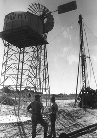
Photograph, Gibbons, Denis, Hoi My Southern Cross Windmill 1
Denis Gibbons (1937 – 2011) Trained with the Australian Army, before travelling to Vietnam in January 1966, Denis stayed with the 1st Australian Task Force in Nui Dat working as a photographer. For almost five years Gibbons toured with nine Australian infantry battalions, posting compelling war images from within many combat zones before being flown out in late November 1970 after sustaining injuries. The images held within the National Vietnam Veterans Museum make up the Gibbons Collection.A black and white photograph of the Hoi My Southern Cross Windmill water pump and the water pressure header tower. Pipes and taps were laid from the header tank to various access points throughout the village.photograph, 1st australian civil affairs unit, hoi my southern cross windmill, gibbons collection catalogue, denis gibbons, photographer, vietnam war -
 National Vietnam Veterans Museum (NVVM)
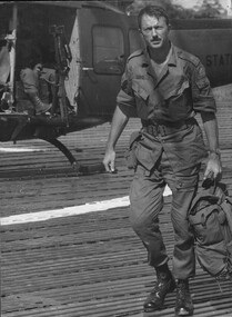
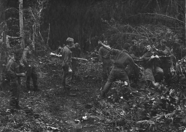
Photograph, Gibbons, Denis
Denis Gibbons (1937 – 2011) Trained with the Australian Army, before travelling to Vietnam in January 1966, Denis stayed with the 1st Australian Task Force in Nui Dat working as a photographer. For almost five years Gibbons toured with nine Australian infantry battalions, posting compelling war images from within many combat zones before being flown out in late November 1970 after sustaining injuries. The images held within the National Vietnam Veterans Museum make up the Gibbons Collection.A black and white photograph: Contact....Contact....Contact....late afternoon, platoon strength, North West of 1ATF Operation Atherton, 10 December 1969. 1 Platoon, A Companyy, 8 RAR, thumbs up by Sgt L.E.Fielding and Pte N.J. Robison begins his ascent to the dustoff evacuation helicopter.photograph, 1 atf base, operation atherton, 1 platoon, a coy, 8 rar, sgt l.e. fielding, pte n.j.robinson, dustoff, helicopter, gibbons collection catalogue, denis gibbons, photographer, vietnam war, diggers -
 National Vietnam Veterans Museum (NVVM)
Photograph, Gibbons, Denis, Fire Support Base Discovery 5
Denis Gibbons (1937 – 2011) Trained with the Australian Army, before travelling to Vietnam in January 1966, Denis stayed with the 1st Australian Task Force in Nui Dat working as a photographer. For almost five years Gibbons toured with nine Australian infantry battalions, posting compelling war images from within many combat zones before being flown out in late November 1970 after sustaining injuries. The images held within the National Vietnam Veterans Museum make up the Gibbons Collection. A black and white photograph of Gunners of 1st Field Regiment, RAA, at the 1ATF Base, Nui Dat, Phuoc Tuy Province, Sth Vietnam, breaking open boxes of 105mm artillery shells and prepare and repack them for a parachute drop to 101 Battery at Fire Support Base Discovery (Circa November 1969)photograph, 1st australian field regiment, raa, 1st atf base, nui dat, phuoc tuy province, 105mm artillery, 101 battery, fire support base discovery, gibbons collection catalogue, gunner, denis gibbons, photographer, vietnam war -
 National Vietnam Veterans Museum (NVVM)
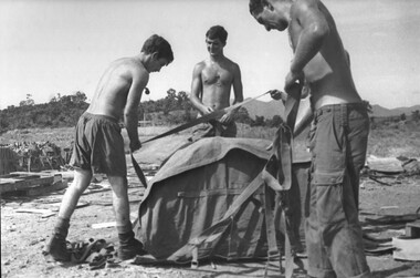
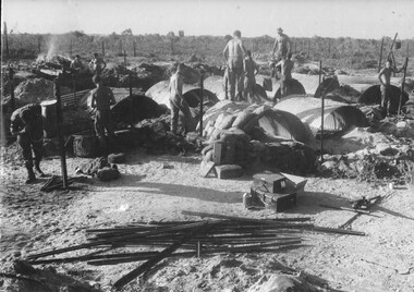
Photograph, Gibbons, Denis, Building Sandbagged Shelters
Denis Gibbons (1937 – 2011) Trained with the Australian Army, before travelling to Vietnam in January 1966, Denis stayed with the 1st Australian Task Force in Nui Dat working as a photographer. For almost five years Gibbons toured with nine Australian infantry battalions, posting compelling war images from within many combat zones before being flown out in late November 1970 after sustaining injuries. The images held within the National Vietnam Veterans Museum make up the Gibbons Collection. .A black and white photograph of Gunners at an Australian Fire Support Base building their sandbagged shelters against possible attack by NVA/VietCong mortar and rocket fire. The gunners became very astute at building their shelters as the artillery batteries moved in support of the infantry.photograph, fire support base, nva/vc, gibbons collection catalogue, denis gibbons, photographer, vietnam war, gunners, infantry