Showing 25230 items matching " north"
-
 Whitehorse Historical Society Inc.
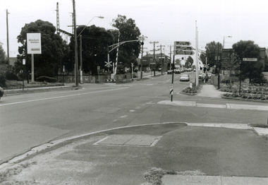
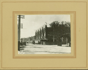
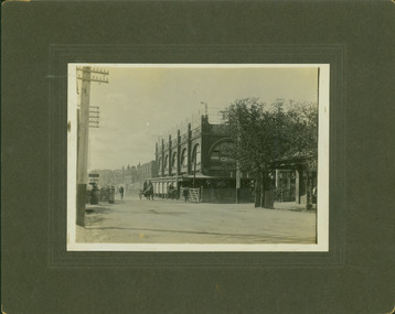
Photograph, Mitcham & Brunswick Roads, 2000
Produced as one of a series of 24 prints commissioned by Nunawading & District Historical Society -|Theme: Intersections of Mitcham and Nunawading 2000/2001.|See also Series by P. Simmenauer on the same theme.Black and white photograph - print and negative of Corner of Mitcham Road and Brunswick Road, Mitcham, looking North towards Railway Crossing. From left-right: Rail Station sign - 'Mitcham/Station/Connex'. On near side corner of Brunswick Road signage for: Mitcham Angling Club; Mitcham Community Centre; Mitcham Senior Citizens Club; Street sign: Brunswick Road.mitcham railway station, connex, mitcham angling club, angler's club, mitcham community house, mitcham senior citizens club, brunswick road, mitcham, mitcham road -
 Wangaratta High School
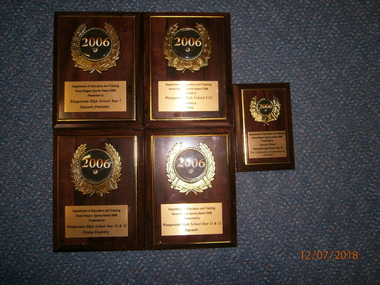
WHS Sports Award, 2006
Brown wooden 2006 Hume North East Region Sports Award plaques with gold metal plate on the bottom section and 3D Year Champion sticker in the centre. Team awards: Year 7 female squash Year 11 & 12 Cross country U21 relay athletics Year 11 & 12 Squash Individual Awards: Jayson Shaw- Baseball Outstanding Achievement -
 Wangaratta High School
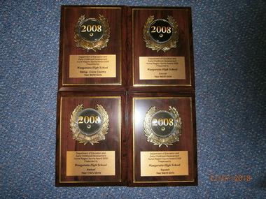
WHS Sports Award, 2008
Brown wooden 2008 Hume North East Region Sports Award plaques with gold metal plate on the bottom section and 3D Year Champion sticker in the centre. Team awards: Year 9 & 10 girls cross country Skiing Year 9 & 10 girls soccer Year 9 & 10 girls squash Year 11 & 12 girls netball -
 Wangaratta High School
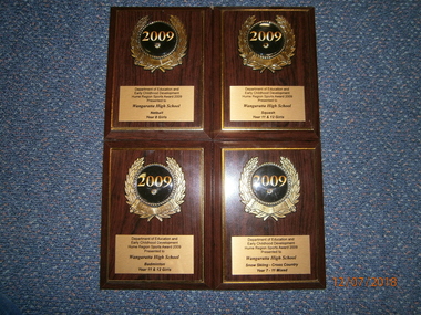
WHS Sports Award, 2009
Brown wooden 2009 Hume North East Region Sports Award plaques with gold metal plate on the bottom section and 3D Year Champion sticker in the centre. Team awards: Year 8 girls Netball Year 7-11 mixed Cross country snow Skiing Year 11 & 12 girls Squash Year 11 & 12 girls Badminton -
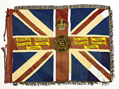 Australian Army Museum of Western Australia
Queen's Colour - 16th Battalion (The Cameron Highlanders of Western Australia)
With the re-activation of the Citizen Military Forces (CMF) following the Second World War, the 16th/28th Infantry Battalion (The Cameron Highlanders of Western Australia) was raised in 1948 to carry on the identity and traditions of the pre-war 16th and 28th Battalions respectively. The King's and Regimental Colours formerly held by these two battalions were passed on to the new battalion who paraded them in rotation on ceremonial occasions It was decided in 1950 that a new set of Colours would be presented to 16th Battalion. For reasons that still remain unclear, these were manufactured under local arrangement by "cannibalising" the original 1933 set of colours and transferring the devices and battle honours (in the case of the Regimental Colour) to the new Colours. (Reported by Western Command to the Adjutant General -reference file A 107/1/11 dated 30 April 1952). These new colours were presented by Major-General JS Whitelaw, CB, CBE at a parade of the 16th/28th Infantry Battalion held on the Esplanade, Perth, 26 August 1951. (For details of Colours previously presented to 16th Battalion see separate section below). 16th/28th Infantry Battalion became unlinked in March 1952 with both 16th and 28th becoming independent battalions within their own right. With the accession of HM Queen Elizabeth II to the throne in 1953, all Colours that had originally been presented as King's Colours, and were still carried by units on the current Order of Battle, were automatically deemed to be Queen's Colours. Under major reorganisation of the CMF in 1960, all individual infantry battalions that existed at the time within each State were amalgamated to form State regiments, taking effect from 1 July 1960. Thus from that date the 11/44th, 16th and 28th Infantry Battalions were amalgamated to form The Royal Western Australia Regiment. In September 1960, at a ceremonial parade held at Northam Camp, the Colours carried by all former battalions were handed over for safe keeping by the new regiment. Battle Honours for the Second World War were promulgated under Australian Army Order 135/1961 and the 10 selected honours approved for emblazoning on the Queen's Colour were subsequently added in 1962 These former colours were subsequently laid up in the undercroft at the State War Memorial, King's Park on 29 November 1964. These were transferred to the Army Museum of WA in 1988 as part of the Bicentenary Colours Project Previous Colours presented to 16th Battalion The designation "16th" was allocated to several different infantry battalions that had been raised at different stages during changes to organisational structure of the Citizen Forces during the 1920's and 1930's. The original King's Colour awarded for service of 16th Battalion (AIF) and received in 1920 by the Citizen Force unit 2nd Battalion, 16th Infantry Regiment was later passed on to 16th Battalion (The Goldfields Regiment) which had been raised in the Kalgoorlie area in 1921. This unit became inactive and this Colour was later laid up in the Kalgoorlie Council Chambers. In order to maintain the identity of 16th Battalion as a Citizen Force unit, in 1930 11th Battalion (The Perth Regiment) was reformed as a linked battalion under the designation 11th/16th Battalion. As the 11th Battalion had already received its set of colours in the 1920's, it was decided that a set of King's and Regimental Colours be presented for 16th Battalion. These were presented by HE the Lieutenant-Governor Sir James Mitchell, KCMG at a parade of 11th/16th Battalion held at Perth Oval on 15 October 1933. The colours were consecrated by the Chaplain General, Archbishop COL Riley, OBE, VD, DD. In 1936 16th Battalion was re-established as a separate battalion within its own right, being formed as 16th Battalion (The Cameron Highlanders of Western Australia). The colours presented in 1933 were passed on to this new battalion and were also initially carried by the post-World War Two unit 16th/28th Infantry Battalion (The Cameron Highlanders of Western Australia) as already mentioned. Union flag with gold fringe. In the centre the Arabic numeral "16" on a red background within a circle inscribed "SIXTEENTH BATTALION", surmounted by the Crown. Emblazoned on the colour are the following Second World War Battle Honours:- NORTH AFICA 1941, SYRIAN FRONTIER, THE LITANI, SIDON, WADI ZEINI, DAMOUR, KOKODA TRAIL, BUNA-GONA, LIBERATION OF AUSTRALIAN NEW GUINEA, BORNEO -
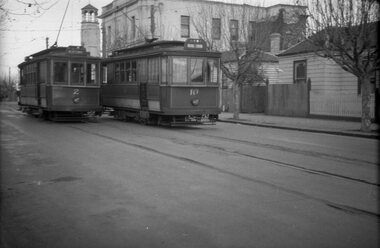 Ballarat Tramway Museum
Negative, Wal Jack, mid 1940's
Negative and Digital images of the Wal Jack Geelong Negative file of Geelong trams 2 and 10 crossing at the Retreat Rd loop in Pakington St, just north of Aphasia St. Tram 2 - has destination of Newtown and 10, East. In the background is 271 Pakington St - City of Newtown and Chilwell offices, in 2020, a Residential property. Photo mid 1940's. trams, tramways, geelong, pakington st, aphasia st, tram 2, tram 10 -
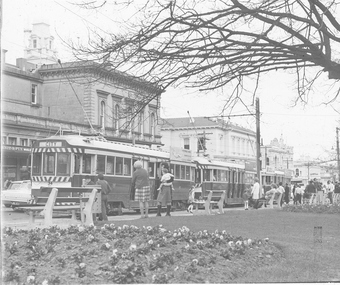 Ballarat Tramway Museum
Photograph - Glass negative, Harvey Studios, 1971
Yields information and has a strong association about the view from the central median strip of Sturt St possibly at the time of the closure of the SEC operated system.Glass negative mounted in a three side metal holder - three bogie trams at the City terminus, Sturt St north side with the ANZ bank and the Post Office in the background. tram 34 at rear. Photo by Harvey Studios, possibly on the last day or one of the closures given the number of people in the photograph with cameras - September 1971 Photo from the collection of Lilian Butler.trams, tramways, sturt st, city -
 Ballarat Tramway Museum
Negative - Set of 4, Campbell Duncan, 2/07/1971 12:00:00 AM
Yields information trams running in Drummond St South.Set of 4 photographs taken on 2/7/1971 of trams in Drummond St south and Skipton St .1 - No. 36 in Drummond St South, city bound to Lydiard St North .2 - 36 and 39 crossing at Bell St loop .3 - near Urquhart St .4 - crossing Sturt St at Hospital Corner with the Southern Cross Hotel in the background.trams, tramways, drummond st sth, sturt st, hospital corner, urquhart st, bell st, tram 36 tram 39 -
 Ballarat Tramway Museum
Photograph - Black & White Photograph/s, Charles Craig, mid 1950's
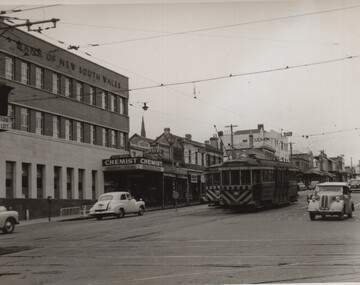
Photograph of the intersection of Ryrie and Moorabool Streets Geelong looking south along Moorabool St, with two bogie trams in Ryrie St, both with safety or hazard stripes. Trams have the destination of Belmont and North. Has the Bank of NSW in the view, E. A. O'Meara Chemist advertising Kodak film and the Geelong Nursery Nook. Adjacent to the tram for Belmont is the safety zone sign. trams, tramways, geelong, ryrie st, moorabool st, traffic lights -
 Ballarat Tramway Museum
Photograph - Black & White Photograph/s, Negative, Ellis Collection, c1950
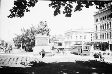
Yields information about the appearance of Sturt St and Lydiard St intersection c1950 and the use of the trams.Black and white photograph of No. 12, Sturt St West in Sturt St at Lydiard St North. Has the National Mutual building and Commonwealth Bank buildings. Bracket arms are of the type that required the pole to be cut into. c1950. Has the Boer War Memorial in the view. Item donated comprised negative 1141, A4 print and laminated A4 print. Negative scanned at 2400dpi. On the top edge of one of the prints "Sturt St Ballarat 1950 no print required"trams, tramways, ballarat, sturt st, secv, lydiard st, statues, tram 12 -
 Ballarat Tramway Museum
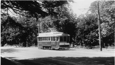
Slide - 35mm slide/s, Keith Caldwell, 12/03/1962 12:00:00 AM
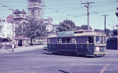
Yields information about the nature of tram services and trams in Lydiard St North and the Town Hall.Agfa colour slide, white cardboard mount, photo by Keith Caldwell on 12/3/1962 of: Tram 13 turning from Sturt St into Lydiard St North, with the Town Hall and other buildings in the background. The Town Hall clock tower has scaffolding around it. The Tram has an Age advertisement on the dash panel and a Georgette Frock Salon - 13 Armstrong St.In ink "Ballarat 12.3.62"tramways, trams, sturt st, town hall, lydiard st north, tram 13 -
 Ballarat Tramway Museum
Photograph - B&W print of donated negative - set of 2, Graham Parry, 1971
Set of two black and white prints and associated negatives of trams in Ballarat during 1971 prior to closure of the system by Graham Parry. All images from the scanned negative. All taken at the Grey St crossing loop. .1 - Nos 39 and 34 crossing. .2 - ditto. No. 39 to Lydiard St North, No. 34 to Sebastopol. Both have SEC Roof adverts.tramways, trams, sebastopol, grey st, albert st tram 39 -
 Ballarat Tramway Museum
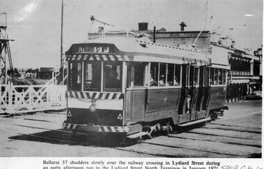
Photograph - Illustration/s, Ballarat 37
Black and white illustration from the South Pacific Electric Railway Co-op (Sydney Tramway Museum) - Feb. 1974 calendar of Ballarat tram No. 37 crossing the railway crossing in Lydiard St. North, January 1971. Photo by D.Cooke. Tram showing destination of "Lydiard St. Nth." Has buildings on the east side of Lydiard St. in background and railway gates.On bottom right hand corner "SPER Calendar February 1974"trams, tramways, ballarat, lydiard st. nth, railway crossing -
 Ballarat Tramway Museum
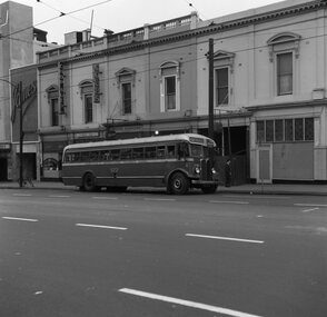
Negative, Geoff Grant, 16/06/1955 12:00:00 AM
Negative No. N306 and black and white print made by a laser printer (stored in folder ) of Bourke St Bus 523 at the Spring St. stop in Bourke St. on the north side. Part of the Imperial Hotel and Metro Theatre in background, along with James, Cobbs, a Chop Suey shop, Jensten? fashions shops. Negative scanned hi res and imaged updated 20/5/2020.trams, tramways, melbourne, bourke st., buses, tram bus 523 -
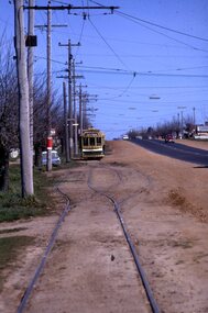 Ballarat Tramway Museum
Slide - 35mm slide/s - set of 3, Mark Plummer, Sep. 1971
Series of three photos of Ballarat No. 17, northbound or inbound in Albert St. Sebastopol, approaching and passing through the Grey (Gray) St. Loop. Note tram stop signs, the loop itself aerial phone lines, the condition of the track and the gravel crossings. Tram has the destination of Lydiard St. North. Kodak cardboard mount slide, taken Mark Plummer, September 1971tramways, trams, albert st, sebastopol, grey st, loops, tram 17 -
 Ballarat Tramway Museum
Photograph - Black & White Photograph/s, Dave Macartney, late 1970's
Black and white photograph of SEC tram No. 33, operated by BTM, in Wendouree Parade, just to the north of Depot Junction, late 1970's . Tram has Eureka and SEC roof ads on side of tram, and is showing destination of Sturt St. West, indicating possibly soon after recommissioning in 1977. Small copy added 10/10/2019. Image updated.trams, tramways, ballarat, btps, wendouree parade , tram 33 -
 Ballarat Tramway Museum
Photograph - Black & White Photograph/s, George Netherway, 25/05/1937 12:00:00 AM
Copy photograph of a small photograph contained within item Reg. No. 587. Photo is of the construction of the Lydiard St. North extension in 1937. Caption from 587 is "Looking South from Walker St. showing track bed 25.5.37". Has houses on the left side, open land on right side of photograph. Hi Res scan added 25/3/2011trams, tramways, ballarat, lydiard st. nth extension, new track, tramways -
 Ballarat Tramway Museum
Slide - 35mm slide/s - set of 2, Theo Dunstan, May. 1973
Set of two 35mm slides, square format mounted in a "Kodak " cardboard slide mount with Kodak logos and printing of No. Bendigo No. 25 at the Central Deborah terminus with buildings in background and North Bendigo terminus with the driver standing alongside the front of the tram. No. 25 painted in the Bendigo Trust / ESCo livery. Tram has the destination of Golden Square. Taken May 1973 or earlier.Has date of "May 73" and "18" "19" stamped onto the slide. 3245.1 - "Tourist tram at Deborah Mine Bendigo" in blue ink. 3245.2 - Tourist tram at Joss House, Bendigo".tramways, trams, bendigo, tram 25 -
 Bendigo Historical Society Inc.
Newspaper - Newspaper articles - North Central Loddon Region
8375a: The Victorian soldier settlement scheme created in 1917 to lease farming land to soldiers and nurses returning from WW1. The Scheme was heavily criticised. Some reasons for this were the settlers' lack of capital, the size of the land allocated, and the prices of agricultural products both purchased and sold by the farmers. In the wake of WW2, the soldier settlement scheme was refined and, under the supervision of the Soldier Settlement Commission, was re-established. The Yarraberb Settlement was one of the settlements established in 1948. 8375b: Archibald Edmund "Archie" Robertson was born in Eaglehawk in 1884 to Martin Robertson and Anna Margaretha/Hannah Marguerita (nee. Weseloh/Wesloah). Robertson was a commissioned officer during WW1 and contributed to the welfare and advancement of the California Gully community. Following his death in 1922, following a fall from his bike, the community honoured Robertson with a memorial seat in 1923.A3 colour photocopies of newspaper articles pertaining to the North Central Victoria Region. Date of photocopy unknown. Location of original paper unknown (likely the Eaglehawk Times, unable to confirm). Both articles were cut from a larger paper. Article 8375a briefly describes the Yarraberb Solider Settlement. Article 8375b recounts the dedication of Archie Robertson's seat in California Gully. newspaper, eaglehawk heritage society, yarraberb soldiers settlement, soldier settlement commission, archie robertson, california gully, ww1, ww2 -
 Ballarat Tramway Museum
Slide - 35mm slide/s, Wal Jack, 11/03/1964 12:00:00 AM
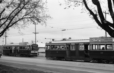
Photo of Ballarat trams 28, 14, 42 en route to City and 38 in background going to Sebastopol, Drummond St. South, just north of Urquhart St., 11-3-1964. Trams 28 and 14 have small white stripe under dash canopy lights. 28 fitted with Castrol and 'Switch to electric cooking' ads, 14 has ads as well.'Ballarat Trams No. 28, 14, 42 to city, 38 Sebastopol. Drummond St. South, 11-3-64.' in blue inktramways, trams, drummond st. sth, sebastopol, tram 28, tram 14, tram 42 -
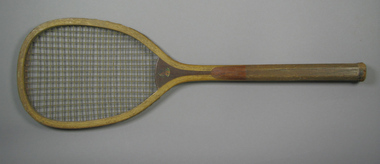 Tennis Australia
Racquet, Circa 1906
A wooden, transitional flat-top racquet with a laminated convex throat. Decal profile bust image across throat on obverse is of a male North American native. Inscription across right side of stem is largely lost, but originally read: THE BRIDGEPORT GUN IMPLEMENT CO./NEW YORK, U.S.A. Materials: Wood, Gut, String, Leather, Metal, Ink, Glue, Lacquertennis -
 Kew Historical Society Inc
Photograph - Railway level crossing in Glenferrie Road, Glenferrie, E.J. Dower, c.1912
One of a series of photographs, taken by Edgar James Dower in the second decade of the twentieth century. Born and raised in Olinda, his family later moved to Surrey Hills. He worked as an adult as a clerk in the city office of the Metropolitan Gas Company, and in his role as a 'collector', he was able to photograph scenes including the construction of tramlines and associated buildings in Kew, Hawthorn, Camberwell and Surrey Hills. Later he established a real estate agency with his brother - the E.J. Dower Real Estate Agency, Dandenong Office.The image is an historically significant record of the development of transport infrastructure which was used to connect Victorians in the first two decades of the twentieth century. This development resulted from increases in population and the consequent extension of Melbourne's suburbs. The photographs, both individually and collectively, richly detail the labour of workers and the tools and machinery used to create and extend Melbourne's public transport network in the years preceding and during World War 1.Digital copy of an original mounted photograph showing Glenferrie Road Hawthorn, looking north towards the old railway level crossing that existed before the line was elevated on a bridge over Glenferrie Road. "The Don Store" at right is immediately behind the old railway level crossing. The tree and shops at left before the crossing were to be removed / demolished as part of the realignment of the train tracks.Annotated verso: "1914 [deleted]/1913 / Glenferrie Road showing railway gates / Taken just before the commencement of the regrading of railway line to Camberwell".theme --- travelling by tram, theme -- connecting victorians by transport and communications, glenferrie road -- hawthorn (vic.), railways -- hawthorn, the don store -- hawthorn (vic.) -
 Kew Historical Society Inc
Photograph - Railway level crossing in Glenferrie Road, Glenferrie, E.J. Dower, 1912
One of a series of photographs, taken by Edgar James Dower in the second decade of the twentieth century. Born and raised in Olinda, his family later moved to Surrey Hills. He worked as an adult as a clerk in the city office of the Metropolitan Gas Company, and in his role as a 'collector', he was able to photograph scenes including the construction of tramlines and associated buildings in Kew, Hawthorn, Camberwell and Surrey Hills. Later he established a real estate agency with his brother - the E.J. Dower Real Estate Agency, Dandenong Office.The image is an historically significant record of the development of transport infrastructure which was used to connect Victorians in the first two decades of the twentieth century. This development resulted from increases in population and the consequent extension of Melbourne's suburbs. The photographs, both individually and collectively, richly detail the labour of workers and the tools and machinery used to create and extend Melbourne's public transport network in the years preceding and during World War 1.Digital copy of an original mounted photograph showing Glenferrie Road Hawthorn, looking north towards the old railway level crossing that existed before the line was elevated on a bridge over Glenferrie Road. "The Don Store" at right is immediately behind the old railway level crossing. The tree and shops at left before the crossing were to be removed / demolished as part of the realignment of the train tracks.Annotated verso: "Glenferrie Road, Glenferrie, showing railway gates and Walker's Store / Taken prior to the construction of electric tramline and the regrading of Camberwell Railway Line / Taken by E.J. Dower about 1912".theme --- travelling by tram, theme -- connecting victorians by transport and communications, glenferrie road -- hawthorn (vic.), railways -- hawthorn, the don store -- hawthorn (vic.) -
 Kew Historical Society Inc
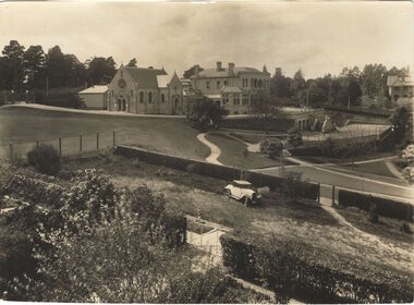
Photograph, Burke Hall, Xavier Preparatory School, circa 1930, c. 1930
This work forms part of the collection assembled by the historian Dorothy Rogers, that was donated to the Kew Historical Society by her son John Rogers in 2015. The manuscripts, photographs, maps, and documents were sourced by her from both family and local collections or produced as references for her print publications. Many were directly used by Rogers in writing ‘Lovely Old Homes of Kew’ (1961) and 'A History of Kew' (1973), or the numerous articles on local history that she produced for suburban newspapers. Most of the photographs in the collection include detailed annotations in her hand. The Rogers Collection provides a comprehensive insight into the working habits of a historian in the 1960s and 1970s. Together it forms the largest privately-donated collection within the archives of the Kew Historical Society.A panoramic photograph of the grounds of Xavier Preparatory School taken from the vicinity of Studley House, looking north east towards Burke Hall (originally Studley Hall). The foreground to the left of the chapel is an oval known as the Chapel Oval (later known as Studley Oval). The ground to the right front is now known as the Jack Gervasoni oval. The house to the far right (part view) is "Campion".Burke Hall (Xavier Preparatory School) formerly Waverley. Built by Charles Griffiths ca. 1869 (Panoramic view from East [sic]) burke hall, studley hall, xavier preparatory school, kew, studley park, dorothy rogers, chapel oval, jack gervasoni oval, burke hall chapel, studley oval, charles griffiths -
 Queen Victoria Women's Centre
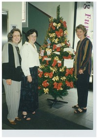
Photograph, December 1997
Colour photograph. Christmas 1997 Networking and Shilling Fund Breakfast. Three women are standing in the ground floor north foyer of the QVWC building. They stand around a Christmas tree adorned with multiple and various dollar notes. Left to right: Glenys Sharma (first General Manager), Kerri Ward (Marketing from Francis Tobin & Associates) and Janet England (first Chair of the Trust). Was a standard size but has been cut. christmas decorations, christmas, fundraising events -
 Surrey Hills Historical Society Collection
Map, Contour map of Surrey Hills showing potential sites for the Telecom Tower
The PMG / Telecom / Telstra tower was built in 1961-1963 as a relay station to support television and radio links between city and regional broadcasting stations. The tower itself was 45 m in height with a 2 storey building for equipment and staff surrounded by garden. From the beginning it was opposed by local residents. The location is said to be the second highest site in Melbourne, sometimes described as Delaney's Hill.Two A3 photocopied sheets of a map showing part of Surrey Hills, roughly between Windsor Crescent and Belmont Street (north / south) and Standard Avenue and Balmoral Crescent (east / west). The map shows contour lines and house sites, 16 of which are numbered. One sheet has been inscribed in top RH corner with notes regarding the significance of the numbers."Contour map of potential sites / for the telecommunications tower which / was eventually sited at 2. / Jock Campbell OBE was our neighbour / at 4 Theodore St when we moved into / the area in 1984. He was responsible in his / job at the PMG in deciding on the /site of the tower - Note site 5 was / behind his (& our) house. / Jack ended his career as Deputy Director / of the PMG. He sat on international committees / after WW2 to decide the split of the electronic / spectrum for radio, TV etc. / His group developed a "mobile phone" using / fixed towers but the phone was a truck full of gear."contour map, telecom tower, maps, jock campbell, john duncan campbell -
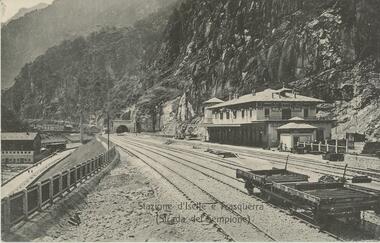 Bendigo Historical Society Inc.
Postcard - ROY AND DORIS KELLY COLLECTION: STAZIONE D'ISELLE E TRASQUERRA (STRADA DEL SEMPIONE), CARTE POSTALE, 1900-1920
Postcard, B&W photo of the railway station serving the villages of Iselle and Trasquerra in the Piedmont region of north west Italy. It was opened in 1906. The rail tracks lead to the entrance of the Simplon Tunnel in the distance. An empty flat tray carriage sits on the tracks (lower right). Part of the the Simplon road (Strada del Sempione) is shown at lower left. This road connects Italy to Switzerland.postcard, photograph, postcard, iselle, trasquerra, italy, station, simplon tunnel. -
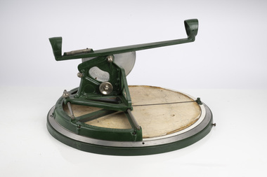 Department of Energy, Environment and Climate Action
Fire Finder
Victoria once had well over one hundred fire lookouts and firetowers. Fire lookouts, or observation posts, were often just a clearing on a hill or a vantage point, whereas firetowers were definite structures. Many were established by the Forests Commission Victoria (FCV) in the 1920s, but the network was expanded rapidly in response to recommendations of the Stretton Royal Commission after the 1939 Black Friday bushfires. When a fire or smoke was spotted from the tower a bearing was taken with the alidade and radioed or telephoned into the district office. It was then cross referenced with bearings from other towers on a large wall map to give a "fix" on the fire location. Alidades and telescopes were used in the post war period but were replaced with a much simpler map table and reference string suspended from the centre of the tower cabin. This "Fire Finder" was used in Canadian fire towers to identify the location of wildfires. The unique design was first developed by the British Columbia Forest Service (BCFS) in the early 1950s. Close examination of the map indicates that this particular Fire Finder may have been once used at Bluejoint Mountain lookout in Granby Provincial Park. This Fire Finder was a gift to Barry (Rocky) Marsden from the British Columbia Forest Service in the late 1980s in recognition of the close relationships that had been forged with the staff at the Altona Workshops over many decades. Fire Finders were originally painted black but this one was repainted green after it arrived at Altona. The BC Forest Service had a large facility where they manufactured Fire Finders and many other items of equipment, but in the 1980s it was shut down. Heavy cast iron circular object with a paper topographic map mounted on it. The metal dial and ruler works similar to a compass. The sight tube is used to determine the bearing and elevation of the fire on the map. This Fire Finder also sometimes known as an Alidade. Its a different design from the Osborne Fire Finder widely used in North American fire lookouts from the 1920s. British Columbia Forest Service. Model 62A. Serial Number 6308.bushfire -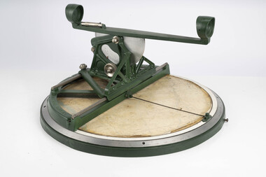
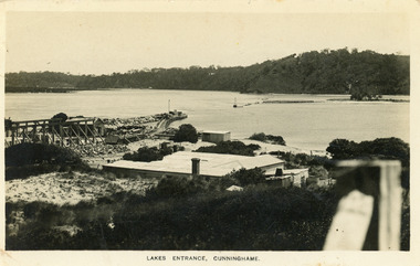 Lakes Entrance Historical Society
Postcard - New Works, Bulmer H D, 1910c
Also second copy same sizeBlack and white postcard showing view of Works buildings and north end of eastern pier. Cunninghame Arm and tip of Bullock Island and groyne work on right. Reeves channel and tip of Rigby Island on left. Mt Barkly and Kalimna Hills in background. Photo taken from top of dune. Roof of Carstairs boarding house centre foreground. Lakes Entrance VictoriaLakes Entrance, Cunninghamewaterways, settlement, historic buildings