Showing 123770 items matching "main-road"
-
 Ballarat Tramway Museum
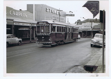
Photograph - Digital image, Wal Jack, 1/07/1961 12:00:00 AM
Yields information about the development of the development of the Main and Victoria St intersection, bogie trams and Stones Corner in 1961.Digital image from the Wal Jack Ballarat Album of a photograph of No.37 in bound from Mt Pleasant, in Main St, about to arrive at Stones Corner. Tram has the destination of Gardens via Drummond North. Photo Wal Jack taken on 1-7-1961. In the background are Stones, Treadwell carpets and Verna Cake shop. The mark on the photograph is from a photo corner that was stuck to the surface and the time of the scanning, after it became loose. See image i2 for rear of photograph.On rear of photograph in ink "SEC, Ballarat No. 37 (ex Bendigo No. 1) Main St, Ballarat East 1-7-61"trams, tramways, stones corner, main st, tram 37 -
 Melbourne Tram Museum
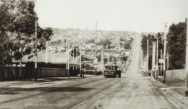
Photograph - Black and white - Whitehorse Road, Balwyn c1920's
Shows B class tram number 90, east bound in Whitehorse Road, at the intersection with Burke Road. Photo has a caption "Whitehorse Road Balwyn c1920s". Tram has the PMTT style destination board. There are a number of people standing on the right hand side of the tram. Note the shelter on the left hand side. This shelter remains in same position (2022). Tram No. 90, was built by James Moore during 1917-1918 and was sold to the Electric Supply Co of Victoria in 1931 and became Bendigo No 7.Yields information about the location, the landscape and the trams in use at the time.Black and white photograph of an outbound tram in Whitehorse Road c1920s, looking east.tramways, balwyn, whitehorse road, tram 90, shelters, pmtt, james moore, b class -
 Glen Eira Historical Society
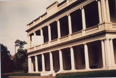
Album - Album page, Ripponlea, 192 Hotham Street, Circa 1972
This photograph is part of the Caulfield Historical Album 1972. This album was created in approximately 1972 as part of a project by the Caulfield Historical Society to assist in identifying buildings worthy of preservation. The album is related to a Survey the Caulfield Historical Society developed in collaboration with the National Trust of Australia (Victoria) and Caulfield City Council to identify historic buildings within the City of Caulfield that warranted the protection of a National Trust Classification. Principal photographer thought to be Trevor Hart, member of Caulfield Historical Society. Most photographs were taken between 1966-1972 with a small number of photographs being older and from unknown sources. All photographs are black and white except where stated, with 386 photographs over 198 pages.From Victorian Heritage Database citation for Rippon Lea H0614 https://vhd.heritagecouncil.vic.gov.au/places/427(as at 23/10/2020) Rippon Lea was commenced in 1868 by Frederick Sargood, a most successful politician and merchant. He was born in England in 1834 and arrived in Melbourne in 1850. He soon joined his father's wholesale soft goods firm, spending some time as its manager on the goldfields. Sargood entered the Legislative Council in 1874. He was Victoria's first Minister for Defence in 1883. Sir Frederick Sargood was created CMG. In 1885 and KCMG in 1890 as a reward for his contribution to public life. He died suddenly in 1903. Rippon Lea was designed by the leading firm of architects, Reed and Barnes. Joseph Reed had travelled in Europe in 1863, including northern Italy. When he returned he introduced the use of polychromy. While not the first examples, Rippon Lea and the Independent Church in Collins Street were the best and set a fashion which became a distinctly Melbourne style, particularly used for houses and churches. Its popularity was possible because of the new availability of different coloured bricks. Reed's fine Lombardic Romanesque details soon became debased by others. As Sargood's family grew and his fortunes prospered, Rippon Lea was extended to include 33 rooms - a complete mansion. The cast iron porte cochere and the northern conservatory were added in 1897. The architects were Taylor and Fitts. The ballroom was added in 1882 and remodelled in 1889. Many alterations have changed the interior and exterior during the ownerships of Benjamin Nathan and later his daughter Mrs Louisa Jones in the 1930s and are in their own right of significance. Sir Thomas Bent owned the property from 1903 until 1911 but never lived there. He subdivided much of the land. The original garden dates from about 1868, and it seems that William Guilfoyle of the Botanic Gardens was involved. It was redesigned in a more natural style in the 1880s by Sargood and his head gardener, Adam Anderson. The lake, waterfalls, fernery, hill and grotto are balanced by mighty deciduous trees and conifers. These are interspersed with, but never dominated by Australian species such as eucalyptus and other exotics. The sinuous drive with its carefully prepared approach to the house is notable. The original vegetable gardens, orchard and outer paddocks no longer survive. The shade house is important as the largest known in Australia and possibly the world. Its curved plan and form of construction are particularly notable. It was built about 1884.Page 90 of Photograph Album with five photographs (one landscape and 4 portrait) of Ripponlea - two different views of the front entrance to the mansion, one of the front gates and two different views of the main residence.Handwritten: "Ripponlea" 192 Hotham Street [top right] / North [under top left photo] / Neg 255 Dec 1972 MAIN DRIVE [under bottom left photo] / Neg 238 8 OCT 1966 [under middle right photo] / 88 [bottom right]trevor hart, elsternwick, mansion, hotham street, frederick sargood, reed and barnes, cast iron porte cochere, conservatory, 1860's, 1890's, ballroom, 1880's, benjamin nathan, louisa jones, thomas bent, sir thomas bent, william guilfoyle, adam anderson, lake, grotto, shade house, portico, ripponlea, victorian, sir frederick sargood, architects, polychrome bricks, lombardic romanesque architectural style, rippon lea, taylor and fitts, land subdivisions, gardens, drives, vegetable gardens, orchards -
 Glen Eira Historical Society
Plan - Warrigal Road, Oakleigh
Documents about a small portion of land on Warrigal Road Oakleigh, now Oakleigh East. A Letter dated 29/05/1952 from Gas and Fuel Corporation of Victoria to Mr. L.P. Simmonds requesting valuation of land for proposed widening of Warrigal Road. A plan of Survey, no.5474, for Crown portion of Parish of Moorabbin and Parish of Mordialloc for owner The Brighton Gas Coy Ltd. New Street Brighton. Mortgages to the National Mutual Life Association. A letter dated 04/06/1952 from Gas and Fuel Corporation of Victoria in reference to Warrigal Road and Centre Road from the Country Roads Board who desire to acquire the land. Handwritten calculation notes and price for valuation, most likely as an attachment to the letter dated 04/06/1952.gas and fuel corporation, warrigal road, centre road, moorabbin council, simmonds l.p, survey plan, county of bourke, the brighton gas company ltd., country roads board, the national mutual life association of australia ltd., bentleigh east -
 Whitehorse Historical Society Inc.
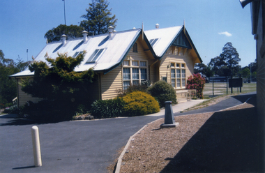
Photograph, Vermont Primary School
The Vermont Primary School No.1022 began operating in 1882. By 1958 a new school was built in Nurlendi Road, Vermont. After standing derelict for many years, the school was moved to the Nurlendi Road site in 1992Coloured photograph of a section of the original Vermont Primary School building, now on the Nurlendi Road sitevermont primary school no. 1022, schools -
 Ringwood and District Historical Society
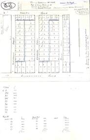
Plan, Plan of Subdivision No.11498 with handwritten costing notations - East Ringwood Central Estate c.1948
Two handwritten pages showing layout of Subdivision no 11498 with surveyor notations including property sizes and road construction cost calculations. Drainage easement 6 feet wide shaded blue.Plan of Subdivision No. 11498, Part of Crown Allotment 27, Parish of Ringwood, County of Mornington, (Certificate of Title Vol 5120 Fol 1023945). Owner Mr Vogel. Subdivision includes Knaith Road, Northwood Street, Langley Street, Bondi Street, and Government Road (later Alexandra Road), Ringwood East. G. Parsons & Sons, Licensed Surveyors, 389 Flinders Lane (Melbourne). -
 Eltham District Historical Society Inc
Photograph, Doug Orford, Completion of bridge works across Yarra River at rear of Eltham Lower Park, July 2004
Bitumen shared pathway under construction at the new Eltham-Templestowe footbridge over the Yarra River off Homestead Road, Eltham which was completed in July 2004. The Yarra River Footbridge was opened in August 2004 and links the Diamond Creek Trail between the Shire of Nillumbik and City of Manningham. It is a shared pathway and also links with the Main Yarra Trail. It affords lovely views over the Yarra River.Three colour photographs showing commencement of construction of Eltham-Templestowe footbridge over Yarra River off Homestead Road, Eltham which was completed July 2004. Third photograph of dedictaion plaque at opening 30 Aug 2004bridges, yarra river, eltham south, eltham lower park, lenister farm, homestead road, asphaldt, bitumen, shared pathway, diamond creek trail -
 Orbost & District Historical Society
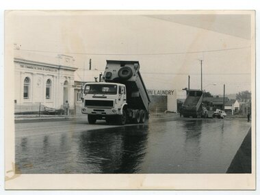
black and white photographs, 1984
These photographs were taken in the main street of Orbost looking south along Nicholson Street. Nicholson Street was remade in 1984 with new kerb alignments, the introduction of red brick paving and the planting of oak trees. This has since been changed.These photographs are pictorial records of construction in the main street of Orbost.Two black / white photographs of roadworks. 3278.1 is of two tip trucks on a newly sealed road. The commonwealth Bank is on the left and in the background is a sign to "COIN LAUNDRY'. 3278.2 is of three men at the edge of the road, backs to the camera.3278.1 - on back - "Resealing of Nicholson Street, Orbost, 1984" 3278.2 - on back - "Peter Dreverman in middle"orbost-nicholson-street construction-nicholson-street roadworks streetscape -
 Whitehorse Historical Society Inc.
Photograph, Former Shire Offices, 1973
Later used as Offices by Country Roads BoardBlack and white photo of Municipal Office for the Shire of Blackburn and Mitcham, 360 Whitehorse Road, Nunawading. Later the City of Nunawading. - Sold to the Country Roads Board (C.R.B.), later known as Vicroads until sold in mid 1990s. Photo taken in 1973.shire of blackburn and mitcham chambers, victoria. country roads board, vicroads, whitehorse road, nunawading, no 360 -
 Whitehorse Historical Society Inc.
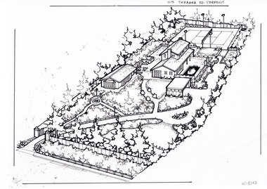
Artwork, other - Ink Line Drawing, Margaret Picken, 103 Terrara Rd. Vermont, circa 1985-2005
A property illustration by Margaret Picken Commissioned by a real estate agency for the purpose of advertising 103 Terrara Rd. Vermont. This property is listed as having sold in for $400,000 in 1986, and having been sold twice in the interim, sold again in 2004 for $1,080,000. Made by using Rotring ‘Rapidigraph’ drafting pens with Rotring ink on Rapidigraph polyester drafting film, double matte. Trained as a cartographic draftsman within the mining industry, Margaret Picken is an artist who worked producing property illustrations for real estate agencies in eastern suburbs of Victoria from 1983-2005. Retiring from the industry as technological changes favored coloured photography over illustrations, and commissioning companies over sole contractors.This artwork is of Historical Significance as a record of local domestic architecture.A black ink line drawing on drafters film by Margaret Picken, of a birds eye view of a property shown on the diagonal. In the bottom left corner a gated driveway winds toward the upper right, through landscaped gardens. Leading up to a separate multi car garage. There is a sperate annex left of the garage, and the main two story house further back. At the every end of the property is a tennis court.103 Terrara Rd. Vermontwhitehorse historical society, schwerkolt cottage, housing, architecture, margaret picken, house, garden, real estate, vermont, vermont south -
 Melbourne Tram Museum
Photograph - Black and White - HTT trams 11 and 18 Riversdale Road Hawthorn
Photo shows two of the Hawthorn Tramways Trust bogie trams 11 and 18 in Riversdale Road at the intersection with Glenferrie Road, c1916 or later. Tram 11 later became MMTB 117 and then SEC Ballarat 37. Tram 18 became MMTB 124 and then Ballarat 35. Note the letterbox on the right.Yields information about the HTT bogie trams.Photograph - Black and White - HTT trams 11 and 18 Riversdale Road Hawthorntramways, trams, htt, hawthorn tramways trust, tram 11, tram 18, riversdale road, n class -
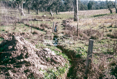 Eltham District Historical Society Inc
Slide, Looking westerly into Martins property, Lower Plenty, 18 July 1972, 1972
Water drainage work undertaken by Eltham Shire Council in Bonds Road, Lower Plenty outside the Martin property opposite Montpelier Drive, July 1972 Note natural gully conditions and open drain cleared through property with owner's consent.35 mm colour positive transparency Mount - Agfacolor Service (Blue)Bonds Road (Martin property) 12.10 pm 18.7.72bonds road, drainage works, eltham shire council, infrastructure, lower plenty, martin property, montpelier drive -
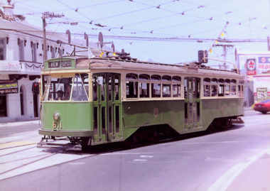 Kew Historical Society Inc
Photograph - Y1 Class 611 in Barkers Road and High Street South, 1990
This colour photograph, with 15 others are enlargements gifted to the Society by Mel Lawrence in 2016. They were taken at a commemorative event from the Kew Tram Depot. Laminated colour enlargement of Y1 Class 611, on the corner of Barkers Road and High Street South, during a re-enactment from the Kew Depot in 1990.Annotation reverse: "Kew Depot 1990. Y1 Class 611, turning out of Barkers Road into High Street South"kew tram depot, trams -- melbourne, y1 class trams -
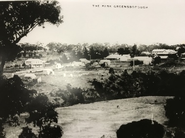 Greensborough Historical Society
Photograph, The Park Greensborough, 1900c
View of Greensborough Park from Partington's Hill, showing sporting ground, Plenty River, Marble Hall, sparse housing on north side of Main Road, the Farmers' Arms hotel, the Rechabite Hall and Main Road bridge over the the railway line. Marble Hall is the double-storied building on the corner of Main Road.Part of a collection of 5 enlarged photographs dating from the early 1900s.Black and white enlargement of photographgreensborough park, main street greensborough, rechabite hall, farmers' arms hotel, marble hall, greensborough railway -
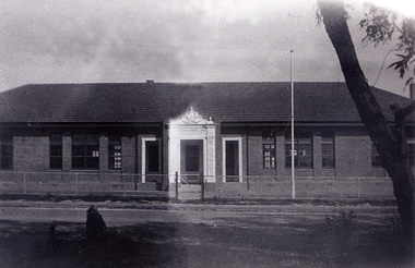 Whitehorse Historical Society Inc.
Photograph, Opening of the Mitcham State School No. 2904
The original Mitcham State School was built in 1888 and was closer to Mitcham Road, Whitehorse Road intersection than this 1929 (and present 2005) location. The donor, Helen Driscoll (nee Fitzsimone) was born in 1922 and lived at 20 Haines Street, Mitcham at the time of the opening.Black and white photograph of the opening of the Mitcham State School No 2904, Mitcham Road in 1929mitcham state school no. 2904 -
 Orbost & District Historical Society
black and white photograph, 1913
This photograph shows the regrowth of vegetation on the road between Genoa and the border - now the Princes Highway.This is a pictorial record of the main road from Orbost to the New South border, The Princes Highway, in the early 20th century.A large black / white photograph of a bush road wwith a vehicle and a man on the side of it.on back - " Princes Highway showing the regrowth.....1913"princes-highway-genoa transport -
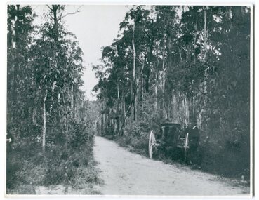
 Whitehorse Historical Society Inc.
Article, Electric Tram Capsizes, 1917
In 1917, a tram capsized in Norwood (Toorak Road) after gathering too much speed which resulted in the death of a boy and injuries to 18 passengers.norwood road, burwood, toorak road, camberwell, tram services, trams -
 Ithacan Historical Society
Photograph, Post office at Stavros, Ithaca, c
The building in the photograph was the post office at Stavros, the main village in the north of Ithaca. Like many small villages with declining populations, the Stavros post office no longer operates and locals must travel to main town of Vathi to access a post office and other services.The permanent population of Ithaca is approximately 3100 (2016) with the majority based in the main town of Vathi. The population in the 1940s was over 8000. Ithaca's population declined sharply after World War II as a result of immigration and movement to larger cities of Greece. This decline was further exacerbated following the earthquake of 1953 which caused widespread devastation across the island.A black and white photograph with a white crinkled edge of a white rendered house with vines growing across the front. The house has been built close to the road. -
![Section of mural from the ballroom of 'Ordsall' [Southesk], Cotham Road](/media/collectors/550653872162f11fb04854aa/items/57295b902162f108e8d6367a/item-media/614c29d34739c077d925ddc5/item-fit-380x285.jpg) Kew Historical Society Inc
Kew Historical Society IncPainting - Section of mural from the ballroom of 'Ordsall' [Southesk], Cotham Road, Cullis Hill & Co, 1882
Ordsall, renamed Southesk in the 20th century was built for John Halfey in or before 1865. The house was rebuilt in the 1870s to designs by architect Michael Hennessy. In 1882 the house was redecorated by the firm of Culls Hill & Co., who hired the artists 'Mr Vandenbrandt' and 'Signor Rizzi" to paint the ceilings of the ballroom and the drawingroom. The artistic triumph was described in detail in The Argus, 30 October, 1882. In 1947, Southesk was purchased by the Kew City Council. For 23 years it was used as a meeting place for community groups. The house was then demolished in 1970 to make way for a new Town Hall.The interiors of the two main reception rooms at Ordsall included some of the most outstanding domestic frescos painted in Australia in the late Victorian period. These frescos were executed by artists hired by the firm of Cullis Hill & Co. While a number of photographs were taken of the interiors prior to the house's demolition in 1970, this small fragment of the fresco is one of only three extant. The fresco allows conservators to examine and evaluate fresco techniques of the period.One of only two fragments of the painted domed ceiling of the ballroom of Ordsall (later renamed Southesk) which once stood at the corner of Cotham Road and Charles Street, Kew. This triangular piece of the fresco is of a cherub's face.Label: 'This is from the "Southesk" ballroom 14-7-70'ordsall, southesk, cullis hill & co. -
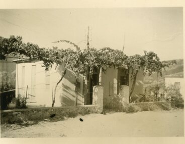
 Kilmore Historical Society
Photograph, Mobil Garage, c2001
Mobil Garage was owned by Danny and Pat D'Elia, they left the premises in 2001.15cm x 10cm colour image of the abandoned Mobil Garage on the corner of Lancefield Road and Sydney Street. Original photograph on standard glossy photograph paper, AGFA brand. Two photographs with slightly differing viewsautomobil repair shops, garages (auto repair), service stations -
Whitehorse Historical Society Inc.
Map, Proposed shared path network, 2001
Draft plans of proposed shared path networkDraft plans of proposed shared path network for Eastern Freeway Extension, Springvale Road to Ringwood.Draft plans of proposed shared path network plans, eastern freeway extension, city of whitehorse, vicroads, city of maroondah, vicroads bicycle coordinator, footpaths, bicycle paths -
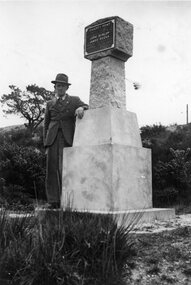 Ballarat Tramway Museum
Photograph - Black & White Photograph/s, Wal Jack, Wal Jack at Poverty Point Monument, Sept. 1946
Photo of a man (Wal Jack) standing by the Gold Monument at Poverty Point at the rear of Main Street Ballarat East. Monument looks new or recently cleaned up. Photo taken Sept. 1946.Has a close association with Wal Jack, an avid collector of Ballarat Tramway and other tramway and railway materials.Black and white photographic print with hand written note on the rear.On rear in ink "Gold Monument at rear of Main Street Ballarat East. / First gold discovered in Ballarat 1851 / Sept 1946." In Wal Jack's handwriting.trams, tramways, ballarat, gold monument, poverty point -
 Kew Historical Society Inc
Photograph - Flooding of the Yarra River in North Kew, 1934
North Kew, now divided between Kew and Kew East, bordered the Yarra River. As such, it was a region subject to flooding in the Yarra Valley. Development beyond this point (ie Kellett Grove) was limited by the City of Kew's planning regulations. Prior to urban development, the area since European settlement and the first land sales in the district in the 1840s, had been used for dairy farming. Small sepia snapshot of floodwaters taken from near Willsmere Road, in what was then known as North Kew. The point of view is looking towards Fairfield. In the foreground are two figures viewing a group in a rowboat in the middle of the flooded river. Semi-submerged street lighting indicates that entire streets had been. overwhelmed by the flood waters. Verso: WILLSMERE ROAD NORTH KEW / Stamped 3 163yarra river -- north kew, floods -- yarra valley, floods -- north kew, floods -- 1934, natural disasters -- kew, willsmere road -
Glen Eira Historical Society
Document - Shoobra Road, 20, Elsternwick
This file contains three articles about this property: Shoobra Road, 20, Elsternwick. 1/Advertising article from unknown source, dated April 2002, by Buxton. Gives brief interior feature details. Includes 3 coloured photographs. 2/Handwritten research on former occupiers of 20 Shoobra Road, taken from Sands and MacDougalls, by Claire Barton 19/06/2012. 3/Advertising feature article in Domain 11-12/11/2016. Article gives details of home renovations update since being bought in 2002. Article details across 3 columns the community values of Elsternwick area and surrounds, and includes a further three properties in the area, also up for auction. It includes a long column titled 'My Patch' from the current owner Amanda Ruben.elsternwick, stavrakis bill, architectural features, shoobra road, buxton, architectural features, real estate agents, bay windows, phelan john., lead lights, phelan f., glenhuntly road glen eira road, marleston park, ruben amanda, gardy mark, gardy cooper, gardy milla, edwardian style, 'miss ruben', restaurants, ripponlea, st. george's road, bertram street, orrong road -
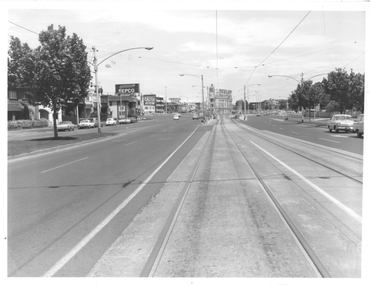 Melbourne Tram Museum
Photograph - St Kilda Road looking south, Melbourne & Metropolitan Tramways Board (MMTB), c1975
Photograph of the south end of St Kilda Road, before the full reconstruction of High Street St Kilda (now St Kilda Road) but after the reconstruction of the Queens Road underpass, photo c1975. Shows the buildings at the junction including the Tower Hotel in the distance. Signs for advertising include Repco, Caltex Astron, UniRoyal Tyres, and Dunlop Tyres. The "Timeline history of Melbourne Tramways etc Barry George et al" gives the date of the opening of the High St section as March 1975.Yields information about the redevelopment of St Kilda Junction.Black and White Photograph with notes on the rear.On rear of photograph in ink "St Kilda Road Junction Stage One complete c1975"trams, tramways, high st, st kilda junction, st kilda rd -
 Orbost & District Historical Society
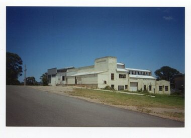
photograph, Johnson, Marina, late 20th century - early 21st century
The second Orbost Butter Factory was based in Forest Road.The Orbost Butter and Produce Co. Ltd was registered on June 1st 1893 and was an important source of income to the Orbost district.A coloured photograph of a large white building - the Orbost Butter Factory. -
 Whitehorse Historical Society Inc.
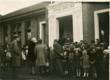
Photograph, Opening of the Mitcham State School No. 2904, 1929
The original Mitcham State School was built in 1888 and was much closer to the Mitcham Road-Whitehorse Road intersection than the 1929 (and present 2005) location. The donor, Helen Driscoll (nee Fitzsimone) was born in 1922 and lived at 20 Haines Street, Mitcham at the time of the openingBlack and white photograph of the opening of the Mitcham State School No 2904, Mitcham Road in 1929mitcham state school no. 2904 -
 Glen Eira Historical Society
Photograph - Kilwinning, Balaclava Road
A colour photograph (101mm x 149mm) of the exterior of the house Kilwinning at Balaclava Road circa 1960. The file also includes two colour photocopies of a photograph (190mm x 239mm) of the exterior of Kilwinning showing the driveway and the garden in full bloom. A handwritten note on one of the copies provides that the house was demolished in 1965.kilwinning, balaclava road, davies j, house names, houses, architectural features, gardens, caulfield, st kilda east -
 Whitehorse Historical Society Inc.
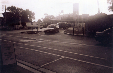
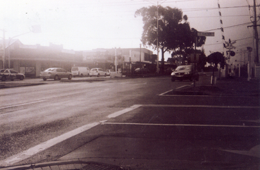
Photograph, The Railway Crossing from Station Street, 1/06/2009
One of a collection of photographs taken of the Nunawading Railway Station prior to the lowering of the railway line and building of the new railway station on the western side of Springvale Road so that the Springvale Road Rail Crossing can be eliminated.Black & white photograph of he precinct surrounding the Nunawading Station and the Springvale Road Railway crossing. This photograph is of the crossing from Station Street. The liquor on the corner of Springvale Road and Oval way is in the background. See NP 3545 to NP3567 for the complete set of photographsnunawading railway station, springvale road nunawading, redevelopment of railway line/springvale road., oval way nunawading -
 Whitehorse Historical Society Inc.
Photograph, Service Station -Now Works Site Office, 1/06/2009
One of a collection of photographs taken of the Nunawading Railway Station prior to the lowering of the railway line and building of the new railway station on the western side of Springvale Road so that the Springvale Road Rail Crossing can be eliminated.Black & white photograph of he precinct surrounding the Nunawading Station and the Springvale Road Railway crossing. This photograph is former Service Station on west side of Springvale Road. Now works site office. See NP 3545 to NP3567 for the complete set of photographsnunawading railway station, springvale road nunawading, redevelopment of railway line/springvale road.