Showing 1452 items matching " allotments"
-
 The Beechworth Burke Museum Research Collection
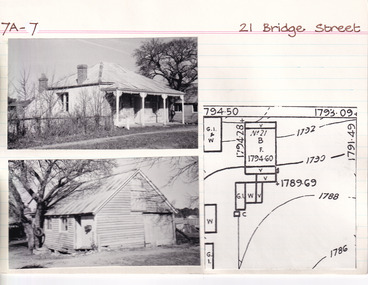
Card (Series) - Index Card, George Tibbits, 21 Bridge Street, Beechworth, 1976
George Tibbits, University of Melbourne. Faculty of Architecture, Building and Town & Regional PlanningIndex system that support the research for Beechworth : historical reconstruction / [by] George Tibbits ... [et al]Arranged by street names of BeechworthEach index card includes: street name and number of property, image of property, allotment and section number, property owners and dates of ownership, description of the property according to rate records, property floor plan with dimensions.beechworth, george tibbitsbeechworth, george tibbits -
 The Beechworth Burke Museum Research Collection
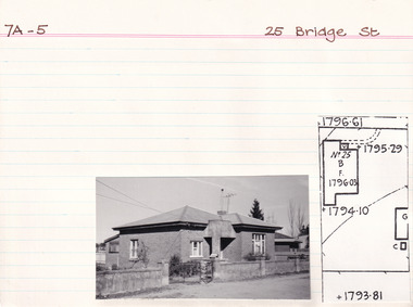
Card (Series) - Index Card, George Tibbits, 25 Bridge Road, Beechworth, 1976
George Tibbits, University of Melbourne. Faculty of Architecture, Building and Town & Regional PlanningIndex system that support the research for Beechworth : historical reconstruction / [by] George Tibbits ... [et al]Arranged by street names of BeechworthEach index card includes: street name and number of property, image of property, allotment and section number, property owners and dates of ownership, description of the property according to rate records, property floor plan with dimensions.beechworth, george tibbitsbeechworth, george tibbits -
 The Beechworth Burke Museum Research Collection
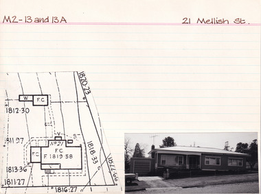
Card (Series) - Index Card, George Tibbits, 21 Mellish Street, Beechworth, 1976
George Tibbits, University of Melbourne. Faculty of Architecture, Building and Town & Regional PlanningIndex system that support the research for Beechworth : historical reconstruction / [by] George Tibbits ... [et al]Arranged by street names of BeechworthEach index card includes: street name and number of property, image of property, allotment and section number, property owners and dates of ownership, description of the property according to rate records, property floor plan with dimensions.beechworth, george tibbitsbeechworth, george tibbits -
 Mission to Seafarers Victoria
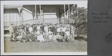
Photograph - Gelatin silver photograph, Picnic group, Finhaven, Kew, Cup Day 1928
Mr John Innerarity Buchan, Scottish real estate, and his wife. organised at least 4 known outings at their property - Finhaven - in Studley Park, Kew. Those parties were hosted for Cup Day in 1920, 1922, 1924 and 1928. Mr Buchan died in December 1922, but his wife continued with the tradition. The house was sold and demolished in 1941 to create several allotments around Finhaven Court.The photograph was published in the 1928 Annual ReportGroup photograph of men and ladies skiing on the grass and standing in front of a house. Reverend Weller is sitting on the grass in the middle first row. on page 13 (page cut from fan album)Picnic group Finhaven Kew Cup Day 1928 on the album pagefinhaven, mr john inerrarity buchan, mrs buchan, cup day, reverend john reginald weller, 1928, fan album -
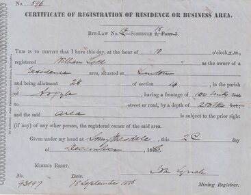 Linton and District Historical Society Inc
Certificate, John Ferres, Government Printer, Melbourne, Certificate of Registration of Residence or Business, William Todd, Linton, 1886, 1886
This certificate was issued to register William Todd as the owner of a residence area at Allotment 28, Section 4, Linton. This land was held under Miner's Right No. 93197. The certificate was issued at Smythesdale on December 2nd by John Lynch, Mining Registrar. Miner's Right No. 93917, 18 September 1886. The Todd family's first home is believed to have been at this site in Grantley Street. See photograph - Registration no. 465.Small blue-grey sheet of paper, black printed, handwritten detail.william todd -
 Kew Historical Society Inc
Plan - Subdivision Plan, J R Mathers & McMillan, Plan of Subdivision of Part of Crown Portion 83 at Kew : LP6669, 1923-1939
In 1888, in the section of Park Hill Road between Belmont Avenue and Normanby Road there was only one street running between Park Hill Road and Cotham Road. This was Park Road, later to be named Adeney Avenue. Subsequent 20th century subdivisions created the ‘through roads’ of Cecil Street, Wimba Avenue, Florence Avenue, Marshall Avenue, Uvadale Road, and Barrington Avenue. This subdivision represents an attempt by auctioneers, rather than town planners to create an urban environment from larger residential allotments or in many cases farmland. Existing streets such as Parkhill and Normanby Roads provided a convenient starting point for the surveyors, but the Road named ‘Street Street’ indicates the role of the private surveyor in creating streets. Given that a number of allotments are listed as sold on the plan, the street is presumably Cecil Street. Even those lots that had been sold do not quite match the dimensions of the blocks in this parcel of land today, indicating that either further subdivisions or boundary alterations occurred.Subdivision plans are historically important documents used as evidence for the growth of suburbs in Australia. They frequently provide information about when the land was sold as well as evidence relating to surveyors and real estate and financial agents. The numerous subdivision plans in the Kew Historical Society's collection represent working documents, ranging from the initial sketches made in planning a subdivision to printed plans on which auctioneers or agents listed the prices for which individual lots were sold. In a number of cases, the reverse of a subdivision plan in the collection includes a photograph of a house that was also for sale by the agent. These photographs provide significant heritage information relating house design and decoration, fencing and household gardens.The photograph may also be aesthetically significant depending on the importance of the photographic atelier.Hand-drawn subdivision plan of 19 lots facing Parkhill Road, Normanby Road, and an unnamed street [now Cecil Street] in Kew.Estate Agent notes in ink indicate those lots which had sold.subdivision plans - kew, parkhill road - kew, cecil street - kew, normanby road - kew, cecil street -kew, parkhill road - kew, normanby road - kew, crown portion 83 - kew -
 Bendigo Historical Society Inc.
Administrative record - The Land Act 1869
The Victorian Parliament passed Land Acts in 1860, 1862 and 1869, which offered settlers land within defined agricultural areas. Settlers paid for half of an allotment on selection at a uniform price of £1 per acre and paid rent on the other half for usually 7 years. By the end of the period, to obtain title to the land, settlers would have had to pay the balance of the purchase price and make certain improvements. (from Wikipedia)Blue book missing front cover, some loose pages. The book contains amendments to the land act 1869. throughout the book there are handwritten notes with names and localitiesRed pen mark at the front Land(?) 869. some of the nameswriten are: Sanderson, O'Brien, H. Jackson, R. Wharton, W. Porter, J. Stewart, Foley and Mortonland act, victorian legislation -
 Federation University Historical Collection
Plan - Plan (copy), Melbourne Road Ballaarat, 1857
This map shows the vicinity of the site of the Eureka Stockade. A3 black and whole photocopy of a plan of Ballarat's Melbourne Road. The plan shows Melbourne Road, Proposed Melbourne Road (later Eureka Street), Chamberlain Street, Queen Street, Allotments between Rodier Street and Stawell Street (William Collard Smith, J & T Oddie, F.A. Edward A. Wynne, David Fitzpatrick, Robert Walsh, Charles Spencer, Alfred Lester, Free Trade Hotel)william collard smith, oddie, wynne, fitzpatrick, walsh, spencer, lester, free trade hotel -
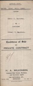 Bendigo Historical Society Inc.
Document - H.A. & S.R. WILKINSON COLLECTION: CONTRACT OF SALE
Conditions of sale by private contract dated 23rd July, 1940 between Mrs. I. Cattran (seller) and Miss V. Sanders (buyer) for land situate No.78 Olinda Street, Bendigo being part of Crown allotment 3 section77C land described in certificate of title volume 4701 folio 940052, together with 4-roomed weatherboard dwelling and all sundry. Price 272 pounds and 10 shillings.organization, business, h.a. & s.r wilkinson real estate -
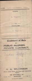
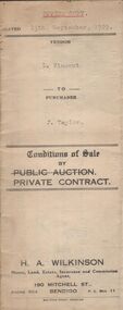 Bendigo Historical Society Inc.
Document - H.A. & S.R. WILKINSON COLLECTION: CONTRACT OF SALE
Conditions of sale by private contract dated 13th September, 1929 between F. Vincent (seller) and J. Taylor (buyer) for land situate Upper Road, California Gully being Crown allotment 292 section M at California Gully, Borough of Eaglehawk described in certificate of title volume 2959 folio 591717, together with 6-roomed weatherboard dwelling and all sundry. Price 210 pounds.organization, business, h.a. & s.r wilkinson real estate -
 Bendigo Historical Society Inc.
Document - H.A. & S.R. WILKINSON COLLECTION: CONDITION OF SALE
Conditions of sale by private contract dated 18th December, 1941 between Mrs. F.E. White (seller) and D.G. Thain (buyer) for land situate corner Echuca and Rodney Streets, Bendigo, at present unoccupied, being part of Crown allotment 17 section 100C described in certificate of title volume 6137 folio 1227385, together with 5-roomed weatherboard dwelling and all sundry. Price 290 pounds.organization, business, h.a. & s.r wilkinson real estate -
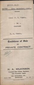
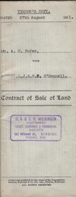 Bendigo Historical Society Inc.
Document - H.A. & S.R. WILKINSON COLLECTION: CONDITION OF SALE
Contract of sale of land dated 27th August 1951 between Mr. A.H. Hufer (seller) and L.J. & W.E. O'Donnell (buyer) for land being part of Crown allotment 11 and 12 section 110C described in certificate of title volume 5322 folio 1064288 situate No. 131 Russell Street, Bendigo, together with 4-roomed weatherboard dwelling and all sundry. Price 2,750 pounds. Vendor's copy.organization, business, h.a. & s.r wilkinson real estate -
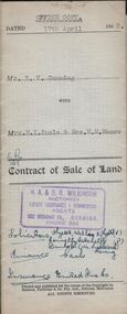 Bendigo Historical Society Inc.
Document - H.A. & S.R. WILKINSON COLLECTION: CONDITION OF SALE
Contract of sale of land dated 17th April, 1953 between Mr. R.V. Cumming (seller) and Mrs.. M.I. Poole & Mrs. M.M. Moore (buyer) for land being part of Crown allotment 32 and 33 section H described in certificate of title volume 7697 folio 106 situate at 131A Sommerville Street Bendigo, together with weatherboard dwelling and all sundry. Price 5,050 pounds.organization, business, h.a. & s.r wilkinson real estate -
 Bendigo Historical Society Inc.
Document - H.A. & S.R. WILKINSON COLLECTION: CONDITION OF SALE
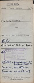
Contract of sale of land dated 10th August, 1953 between Mr. N.V. Wodetzki (seller) and Mr. D. & Mrs. E.M. Phillips for land being part of Crown allotment 7 section 31C described in certificate of title volume 6403, folio 473 situate at No. 158 Barkly Place, Bendigo, together with all registered appurtenant easements. Brick dwelling and all sundry. Price 1,950 pounds.organization, business, h.a. & s.r wilkinson real estate -
 Bendigo Historical Society Inc.
Document - H.A.& S.R. WILKINSON COLLECTION: CONDITION OF SALE
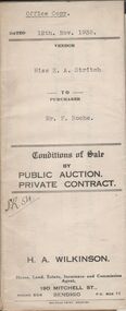
Conditions of sale by private contract dated 12th November 1935 between Miss E.A. Stritch (seller) and Mr. F. Roche (buyer) for land situate No. 81 King Street, Bendigo being part of Crown allotment 15A section 52C described in certificate of title volume 1604 folio 320693, together with 5-roomed weatherboard and brick dwelling and all sundry. Price 375 pounds.organization, business, h.a. & s.r wilkinson real estate -
 Bendigo Historical Society Inc.
Document - H.A.& S.R. WILKINSON COLLECTION: CONDITION OF SALE
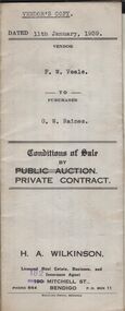
Conditions of sale by private contract dated 11th January, 1939 between F.W. Veale (seller) and G.W. Raines (buyer) for land situate No. 11 Alley Street, Bendigo being part of Crown allotment 70 section A at Ironbark Gully described in deed of conveyance, registered memorial 836 book 532, together with 4-roomed weatherboard dwelling and all sundry. Price 250 pounds - Vendor's copy.organization, business, h.a. & s.r wilkinson real estate -
 Bendigo Historical Society Inc.
Document - H.A. & S.R. WILKINSON COLLECTION: CONDITION OF SALE
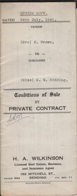
Conditions of sale by private contract dated 24th July, 1941 between Mrs. E. Brown (seller) and Miss A.G. Ridding (buyer) for land situate No.73 Honeysuckle Street, Bendigo being part of Crown allotment 6 section 14B described in Crown grant volume 1056 folio 211103, together with 4-roomed weatherboard and rough cast dwelling and all sundry. Price 615 pounds.organization, business, h.a. & s.r wilkinson real estate -
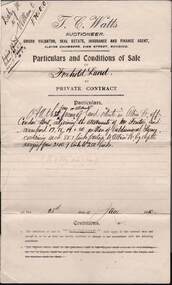 Bendigo Historical Society Inc.
Document - W.D.MASON COLLECTION: CONDITIONS OF SALE, 28 June 1910
Cream Document, W.D.Mason collection, Conditions of Sale, Freehold Land in Albion Street, Bendigo. T.C.Watts Auctioneer and Real Estate Agent, Sworn Valuator, Albion Chambers, View Street, Bendigo. Four land allotments were sold in Albion St, off Condon St., on 28.6.1910 for seventy Pounds. The vendor was Mr John R Daley of Elwood who sold to Owen Williams, Condon St, Bendigo.Cambridge & Young, Printers, Market Square.business, retail, w d mason -
 Bendigo Historical Society Inc.
Document - LANDS OFFICE: APPLICATIONS FOR LEASES RECEIVED AT BENDIGO DISTRICT LAND OFFICE, 2/3/1967 - 29/11/1982
Document: hard cover journal with green cover and buff spine and corners. Contains listing of applications received for leases ( type not specified ) in Bendigo area. LH page: number of application, date of receipt, name, postal address, parish. Rh page: allotment, section, area, recommendation and disposal. On spine in red rectangle ' Land Act applications received' Written on front cover in black ink: application register.Lands Office Bendigocottage, miners -
 Bacchus Marsh & District Historical Society
Map, Gaynor Street Area Land Sales, Maddingley, 1888
This map was produced for a major sale of land in the Maddingley area of Bacchus Marsh in 1888. The sale was conducted by two firms from Melbourne, Carney and Kelly 12 Swanston Street Melbourne. and 'Richardson, Kerr & Co. 40 Flinders Lane Melbourne. 136 blocks were for sale.A single page paper map showing land allotments for sale in the Maddingley area of Bacchus Marsh. Locations shown include Gaynor Street, Maddingley Road South, Parwan Road, Mitchem Street, Typpynge Street, Finn Street and East Maddingley Road. . The map is pasted into a bound volume containing 76 maps or plans in total. High resolution digital image stored on BMDHS computer network. bacchus marsh victoria maps, maddingley victoria maps, land use, maddingley victoria history, land sales bacchus marsh, land sales maddingley -
 Bacchus Marsh & District Historical Society
Map, Gaynor Street Land Sales, Maddingley, circa 1880s-1890s
This map was produced for a major sale of land in the Maddingley area of Bacchus Marsh. The precise date of the sale has not been determined. Features present on the map such as the Bacchus Marsh Railway Station indicate the land sale must have taken place some time after 1887 when the Railway Station opened. A single page paper map showing land allotments for sale in the Maddingley area of Bacchus Marsh. Locations shown include Gaynor Street, Maddingley Road South, Parwan Road, Mitchem Street, Typpynge Street, Finn Street and East Maddingley Road. . The map is pasted into a bound volume containing 76 maps or plans in total. High resolution digital image stored on BMDHS computer network. bacchus marsh victoria maps, maddingley victoria maps, land use, maddingley victoria history, land sales bacchus marsh, land sales maddingley -
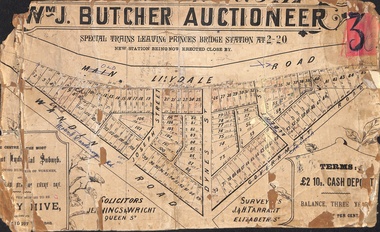 Ringwood and District Historical Society
Poster - Land Sale, Wm J. Butcher, Auctioneer - Albert Park Estate, Ringwood - c.1890
Central section of land sale subdivision advertisement glued to heavy cardboard backing. Photocopied SLV image of original advertisement shows map of 117 allotments for sale in Main Lilydale Road (later Old Lilydale Road), Wandin Road (later Mount Dandenong Road), Joseph Street, Dynes Street, Albert Street (later Wyrunga Street) and Government Road (later Carcoola Road), Ringwood East.Solicitors - Jenningw & Wright, Queen Street. Surveyors - J.&H. Tarrant, Elizabeth Street. Terms £2 10s cash deposit, balance three years at six per cent. -
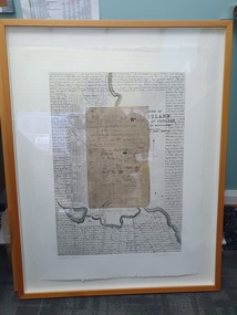 Glenelg Shire Council Cultural Collection
Mixed media - Framed Art Work, Wallace, Carmel et al, Lagoon Page 3, 2004
© Anna Lanyon , Carmel Wallace 2004. Apart from any fair dealing for the purposes of private study, research, criticism or review permitted under the Copyright Act, no text, image or part thereof may be reproduced, stored in a retrieval system, or transmitted in any form, without prior written permission from the authors.This suite of etchings explores the natural and social history of Fawthrop Lagoon, an ancient intertidal lagoon that lies at the heart of Portland on the far south-west coast of Victoria, Australia. The work records and interprets essential moments in the life of the lagoon, the plants, birds, insects, water-creatures and humans who have lived and continue to live around its shores. White card backing with white torn looking inner frame. Centre is print of an extract taken from a survey record of the Fawthrop Lagoon Portland listing the name of the reserve, Allotment number, section number, Township, and Municipality. Markings and dates have been written in. Around the outside of the centre image is hand written wording in fine black ink and a map of the town of Portland also in black ink.4/30 Lagoon, Page 3 Carmel Wallacefawthrop lagoon, portland, victoria, australia, plants, birds, insects, water, creatures, humans -
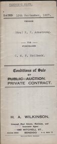 Bendigo Historical Society Inc.
Document - H.A. & S.R. WILKINSON COLLECTION: CONTRACT OF SALE
This business was owned by father and son, Henry Archibald Wilkinson and Samuel Ronald "Ron" Wilkinson. Henry (1882-1954) was born in Shepparton and died in Bendigo. He was married to Grace Hovendon in 1908. Samuel Ronald "Ron" (1914-1995), Henry's son, was married to Florence Jean McKerlie in 1937.Conditions of sale by private contract dated 13th September, 1937 between Mrs. F.P. Armstrong (seller) and C.M.F. Skilbeck (buyer) for land situate 106 Thistle Street, Bendigo being part of Crown allotment 14 section 16B described in certificate of title volume 4386 folio 877150, together with 4-roomed weatherboard dwelling and all sundry. Price 300 pounds. Vendor's copy.organization, business, h.a. & s.r wilkinson real estate -
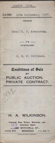 Bendigo Historical Society Inc.
Document - H.A. & S.R. WILKINSON COLLECTION: CONTRACT OF SALE
This business was owned by father and son, Henry Archibald Wilkinson and Samuel Ronald "Ron" Wilkinson. Henry (1882-1954) was born in Shepparton and died in Bendigo. He was married to Grace Hovendon in 1908. Samuel Ronald "Ron" (1914-1995), Henry's son, was married to Florence Jean McKerlie in 1937.Conditions of sale by private contract dated 13th September, 1937 between Mrs. F.P. Armstrong (seller) and C.M.F. Skilbeck (buyer) for land situate 106 Thistle Street, Bendigo being part of Crown allotment 14 section 16B described in certificate of title volume 4386 folio 877150, together with 4-roomed weatherboard dwelling and all sundry. Price 300 pounds. Office copy.organization, business, h.a. & s.r wilkinson real estate -
 Bendigo Historical Society Inc.
Document - H.A. & S.R. WILKINSON COLLECTION: CONTRACT OF SALE
This business was owned by father and son, Henry Archibald Wilkinson and Samuel Ronald "Ron" Wilkinson. Henry (1882-1954) was born in Shepparton and died in Bendigo. He was married to Grace Hovendon in 1908. Samuel Ronald "Ron" (1914-1995), Henry's son, was married to Florence Jean McKerlie in 1937.Conditions of sale by private contract dated 17th March, 1932 between E.F. Fagan & H.R. Fagan (sellers) and M. Scott (buyer) for land situate 69 Neale Street Bendigo being Crown allotment 102, section H described in certificate of title volume 4451 folio 890162, together with 5-roomed weatherboard and brick dwelling and all sundry. Price 300 pounds. Vendor copy.organization, business, h.a. & s.r wilkinson real estate -
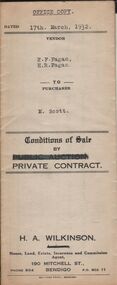 Bendigo Historical Society Inc.
Document - H.A. & S.R. WILKINSON COLLECTION: CONTRACT OF SALE
This business was owned by father and son, Henry Archibald Wilkinson and Samuel Ronald "Ron" Wilkinson. Henry (1882-1954) was born in Shepparton and died in Bendigo. He was married to Grace Hovendon in 1908. Samuel Ronald "Ron" (1914-1995), Henry's son, was married to Florence Jean McKerlie in 1937.Conditions of sale by private contract dated 17th March, 1932 between E.F. Fagan & H.R. Fagan (sellers) and M. Scott (buyer) for land situate 69 Neale Street Bendigo being Crown allotment 102, section H described in certificate of title volume 4451 folio 890162, together with 5-roomed weatherboard and brick dwelling and all sundry. Price 300 pounds. Office copy.organization, business, h.a. & s.r wilkinson real estate -
 Kew Historical Society Inc
Plan - Subdivision Plan, Jas R Mathers Son & McMillan, Eastlawn Estate : East Kew Auction Sale, 1914
The Kew Historical Society's map collection includes a substantial number of real estate subdivision plans, mainly of Kew but also of surrounding suburbs in Melbourne. Most of the subdivision plans date from the 1920s and 1930s when the districts old homes and local farmland were being split up to accommodate residential growth in the postwar period. These early plans were assembled by a local firm, Jas R Mather & McMillan, which had an office in Cotham Road. Many of the plans, and sometimes photos, were annotated by the agents.Subdivision plans are historically important documents used as evidence for the growth of suburbs in Australia. They frequently provide information about when the land was sold as well as evidence relating to surveyors and real estate and financial agents. The numerous subdivision plans in the Kew Historical Society's collection represent working documents, ranging from the initial sketches made in planning a subdivision to printed plans on which auctioneers or agents listed the prices for which individual lots were sold. In a number of cases, the reverse of a subdivision plan in the collection includes a photograph of a house that was also for sale by the agent. These photographs provide significant heritage information relating house design and decoration, fencing and household gardens.The photograph may also be aesthetically significant depending on the importance of the photographic atelier.The ‘Eastlawn Estate’ was surveyed and ready for auction in March 1914, three months before the outbreak of World War I. Sixty-six allotments, created on the ‘order of Mr & Miss Preston’ surrounded the mansion of Woodlands in Harp Road. Woodlands formed part of the Estate, being advertised as lot 1. The allotments faced High, Station and Wright Streets, Harp and Normanby Roads, and Woodlands Avenue. Pru Sanderson in the Kew Conservation Study (Vol.2, 1988) wrote that the Eastlawn Estate ‘covered the western half of the failed Harp of Erin Estate’. Contemporary advertisements promoted the Eastlawn Estate as: ‘There will be no more convenient district nor pleasant Suburb than East Kew for the busy business man. When the Electric Tram is laid, he will be able to journey quickly and pleasantly direct from Collins Street to his home in the Eastlawn Estate in about 20 minutes’. The actual plans of subdivision were included in advertisements in The Argus and in the local newspapers."C" top left. Various annotations.subdivision plans - kew, station street, normanby road, high street, woodlands avenue, harp road, woodlands - kew -
 Kew Historical Society Inc
Plan - Subdivision Plan, Eastlawn Estate, 1914
Subdivision plans are historically important documents used as evidence of the growth of suburbs in Australia. They frequently provide information about when the land was sold on which a built structure was subsequently constructed as well as evidence relating to surveyors and real estate and financial agents. The numerous subdivision plans in the Kew Historical Society's collection represent working documents, ranging from the initial sketches made in planning a subdivision to printed plans on which auctioneers or agents listed the prices for which individual lots were sold. In a number of cases, the reverse of a subdivision plan in the collection includes a photograph of a house that was also for sale by the agent. These photographs provide significant heritage information relating house design and decoration, fencing and household gardens.The ‘Eastlawn Estate’ was surveyed and ready for auction in March 1914, three months before the outbreak of World War I. Sixty-six allotments, created on the ‘order of Mr & Miss Preston’ surrounded the mansion of Woodlands in Harp Road. Woodlands formed part of the Estate, being advertised as lot 1. The allotments faced High, Station and Wright Streets, Harp and Normanby Roads, and Woodlands Avenue. Pru Sanderson in the Kew Conservation Study (Vol.2, 1988) wrote that the Eastlawn Estate ‘covered the western half of the failed Harp of Erin Estate’. Contemporary advertisements promoted the Eastlawn Estate as: ‘There will be no more convenient district nor pleasant Suburb than East Kew for the busy business man. When the Electric Tram is laid, he will be able to journey quickly and pleasantly direct from Collins Street to his home in the Eastlawn Estate in about 20 minutes’. The actual plans of subdivision were included in advertisements in The Argus and in the local newspapers.subdivision plans - east kew, eastlawn estate