Showing 993 items
matching paddocks
-
 University of Melbourne, Burnley Campus Archives
Album - Black and white and colour slides, Teaching Horticulture, 1952-1969
Large collection of slides used for teaching Horticulture. Difficult to identify whether they were taken at Burnley. Labelled and numbered 1-2501. Some dated but spread over 1950's to 1960's. Also 57 slides similar to 1-50 labelled but not numbered. Some photographs have been catalogued elsewhere. Missing numbers have been mixed up with other photographs. 1-50 Mostly fungal diseases. 57 slides not numbered - fungal diseases. 1-29 Mostly mosses. 31-41 Mostly liverworts and hornworts. 43-60 Ferns. 61-73 selaginella. 75-84 Ferns 85-114 Gymnosperms 115-1236 Miscellaneous 117-141 Angiosperms 142-294 Biology 296-307 Orchidaceae 311-316 Acacias 796-841 Trees 866-889 Roses 955-984 Eucalyptus 1009-1046 Greenhouse. 1052-1086, 1097-1152 Propagating fruit trees. 1087-1090 Cacti. 1154-1187 Planting and pruning principles. 1196-1218 Orchard, Nursery. 1211 June 1956. 1215 8/3/57. 1228-1258 Orchard Management. 1263-1345 Crafting and reworking. 1346-1373 Bulk handling. 1390-1400 Leaf scorch. 1424-1472 Vegetables.1473-1512 Potatoes, Research farm Toolangi 2/54. 1514-1686 Garden Design. 1688-1695 Cow Paddock, and in flood. 1958, Students. 1795-1798 P.R.I. 1928-32.1831-1838 Beaumaris Feb 1958.1840-1846 P. Vejjajiva's Farewell 23.2.1958. Pruning Day 2/7/60. 19777-1990 Genetics. 1991-2018 Weeds. 2020-2-50 Erosion. 2023 10/65 and soil conservation. 2072-2136 Fertilizers. 2144-2149 Rhizobia 1950's. 2155-2157 Lime. 2160-2228 Plough, Cultivators, etc. 2246-2296 Tatura 12/59. 2301-2237 Beef and Dairy Cattle. 2338-2354 Sheep. 2355-2372 Crops. 2357-2363 1952. 2364 1958. 2373-2397 Fodder conservation 1952-1956. 2398-2411 Fences. 2398-2406 11/52. 2418-2248 Longerenong Field day 1964. 2451-2455 Boom Sprayer 1960. Glasshouse Wagga Agric College Oct 69. Apr 84 M3 16-18 Cultivator? 2458-2483 Hydraulics,Power Farming Dec 1966-Mar 1967. 2487-2488 Hydrasulics Vane Pump Construction. 2491-2500 Mechanics. 2501 Rack Shaker. Extra 13 Pond life. Some slides see B18.0001: 1676, 1684, some between 1711-1792, 1881, some between 1911-1953.Not scanned yet.teaching, horticulture, greenhouse, propagation, pruning, cacti, planting, orchard nursery, orchard management, grafting and reworking, potatoes, toolangi, garden design, lagoon paddock, beaumaris excursion, p.vejjajiva, lagoon paddock in flood, fungal diseases, genetics, weeds, erosion, fertilizers, rhyzobia, lime, cultivation, tatura, cattle, sheep, crops, fodder, fences, hydraulics, mechanics, longerenong, cow paddock, plough, cultivator, boom sprayer, wagga agricultural college, vane pump -
Federation University Historical Collection
Document - Reports, Martin Westbrooke, Nanya Station
Nanya Station, owned and managed by the University of Ballarat (now Federation University Australia), was purchased with assistance from the Department of Environment and Heritage Government Caring for our Country program. Nanya Station is located in the Scotia country, west of the Darling Ana-Branch in far western New South Wales and consists of the Nanya Western Lands Pastoral Lease 3281 – Perpetual Leasehold Lot 1244 in Deposited Plan 762778, Parish of Winnebaga, County of Tara and part of Lot 1242 County of Windeyer. Nanya is within the tribal area of the Danggali Aboriginal people, a sub-group of the Barkindji. Many Aboriginal sites have been recorded adjacent to major rivers in the region providing evidence that these areas supported a large population. The Scotia region has one of the shortest stock grazing histories of western NSW. Along with five other Scotia properties, Nanya was created as a pastoral lease in 1927. The first European settlement on the land followed exploration of the area by Sturt and Eyre. In 1854, the Lake Victoria lease which encompassed this area comprised 465,000ha.included Scotia blocks 1, 2, 3 and 4, Amoskeag and Winnebaga which formed the area known as the Scotia. It was described as a region of thick mallee scrub, interspersed with bluebush flats and Belah woodland. In the 1920s artesian water was found and the dry Scotia country was surveyed and divided into six Homestead leases allocated by ballot (Withers 1989). All properties were approximately 30,000ha, with a recommended stocking level of 3,000 sheep. Winnebaga (renamed Nanya) was taken up by Gordon Cumming. He initially dug a dam near the southeast corner of the property. A larger ground tank and rudimentary dwelling at the site of the present complex was later established. An adjacent area was cleared and cropped to provide feed for the horses used in digging the earth tanks. The ruins of the original building are located between the shearing shed and Homestead Tank. A cottage was built in the 1930s and a more substantial Red Gum framed homestead in the early 1950s. The lease was held by Mr Gordon Cumming until 1984 when it was purchased by Mr Norm Scadding as an extension to the adjacent lease, Belvedere. It was sold in 1995 to Mr Rob Taylor of Waikerie then in 1999 to BeMax Pty. Ltd., a sand mining company. These last three owners all permitted use of the property by the University for teaching and research. The Centre for Environmental Management at the University of Ballarat had been involved in studies of flora and fauna in western New South Wales since 1988. Studies became concentrated on the Scotia region with its variety of intact ecosystems due to a short pastoral history. Of particular significance is a system of natural salt lakes of which the most extensive is the Scotia Discharge Complex located on Nanya Station. An extensive vegetation survey of the Scotia region Westbrooke et al. 1998) highlighted the significance of the area both in terms of the range of communities in relatively intact condition and the occurrence of species and communities of restricted distribution. Nearly 400 species were recorded of which nine had either not previously been recorded or have restricted distribution in western NSW. Twenty-two plant communities occur on Nanya Station of which two, Halosarcia lylei low open shrubland and Hemichroa diandra/Halosarcia/Frankenia low open shrubland, are dominated by species not previously recorded from NSW. H. lylei and Acacia loderi shrublands are listed as endangered under the NSW Threatened Species Conservation Act. As noted, the area has a relatively short grazing history and, due to the presence of large areas of mallee with a Triodia understorey and restricted water supplies, stocking rates have been low. The diversity of ecosystems in relatively intact condition and extensive areas of old growth mallee made Nanya a highly significant refuge for biological diversity. This factors led to the purchase of Nanya Station by the University of Ballarat in 2004 with the assistance of the Department of Environment and Heritage for the purposes of conservation, research and education. In 2010 the southern paddocks of Nagaella Station (10,000ha.) which lie along the northern boundary, were purchased with the assistance of Lower Murray Darling Catchment Management Authority and added to the Nanya lease to provide complete protection for the communities of the Nanya Discharge Complex and further high quality Malleefowl habitat. Four digital reports documents relating to Federation University's Nanya Station, Western New South Walesnanya station, scotia country, pastoral lease, winnebaga county, darling ana-branch, martin westbrooke, environmental education, nagaella station, lower murray darling catchment management authority, conservation research education, ian gribble, pat prevett, ian henderson, danggali -
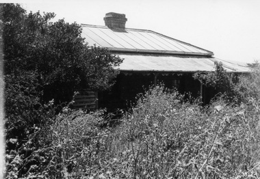 Flagstaff Hill Maritime Museum and Village
Photograph - Set of Photographs, John Chance, late 1960s to early 1970s
This set of glossy black and white photographs is a set of images of Glenample Homestead circa late 1960s to early 1970s. They were taken by John Chance and are part of the John Chance Collection. The Colonial Georgian style Glenample Homestead was built from 1866 to 1869 from locally quarried sandstone. In is built on the top of a hill amongst trees. There are paddocks below and around the building. The building is basically a rectangular shape with a recessed room on the right side of the front. The pitched roof is covered in corrugated iron. The veranda, added in 1886, also has a corrugated iron room and is supported by square posts with decorative tops. It shelters three sides of the building. The edge of the veranda is decorated with scalloped shapes along the front and left side of the building. On the right is a brick wall incorporating a chimney. Another chimney on the left is contained within the building. The four-panelled outside doors are visible in some of the photos, as are the 12-paned glass windows, which are framed in contrasting stone. The veranda is trimmed with scalloped metal work on two sides and had some enclosed corners. There appears to be a cubical water tank on the roof line. Out-buildings include a toilet built against the house's brick wall. Another building appears to have two rooms with outside doors, perhaps for workers. There is the remains of a two-wheeled cart under a shelter. GLENAMPLE & the LOCH ARD Glenample Homestead became famous after the disastrous wreck of the sailing ship Loch Ard on June 1, 1878. The owners, Hugh Hamilton Gibson and Peter McArthur, were involved in the rescue and recovery of the only two survivors, as well as overseeing the salvage of items from the shipwreck and the burial of those who lost their lives. Glenample Homestead is on the Great Ocean Road at Princetown. Originally the land was part of Kennan’s Station lease, one of the district’s early settlements, circa 1847. James Murray bought Kerman’s land in 1856-57, combined it with nearby land, and named it Glenample Homestead. The ruins of huts Murray built on the property were still there until recently. Glenample was sold in 1866 to the partnership of Gibson and McArthur, who built a Georgian style house there using local sandstone, completing it by 1869. On 1st June 1878 the Loch Ard was wrecked at what is now called Loch Ard Gorge. Apprentice crewman Tom Pearce and eighteen year old passenger Eva Carmichael were the only survivors. Pearce had brought Eva ashore and sheltered her in a cave, reviving her with whiskey found amongst items washed up from the wreck. He climbed the cliffs and came across two riders from Glenample. No other survivors were found and sadly, Eva’s family members were amongst those who drowned. Hugh and Lavinia Gibson cared for Pearce and Eva at Glenample and extended their hospitality to Eva, who stayed on for about six weeks as she recovered from the ordeal physically and emotionally. Mrs Gibson introduced Eva to Jane Shields and the young ladies became lifelong friends. Years after Eva had returned to England, Jane’s daughter visited her. Eva handed her a blue china tea set to pass onto her mother as a gift. A descendant of Jane’s donated part of the tea set to Flagstaff Hill Maritime Village while another descendant donated her inherited share of the tea set to the Warrnambool and District Historical Society. In 1886 Glenample Homestead was updated to include a veranda on three sides. In 1887 Gibson sold his share to partner Peter McArthur. McArthur’s son Ernest inherited the property in 1897. Ernest established the Glenample Cheese Factory in around 1911. It was closed due to the World War and reopened in 1929 by McArthur’s sons, Robert and Colin, when they took control. In 1945 they sold Glenample and several owners followed but it was left unoccupied and became dilapidated. It was during this time that John Chance visited the property and photographed the buildings. In the 1980s the National Parks Service acquired the Glenample Homestead and began a restoration program. Work began in 1989 by Cathedral Stone, which was established in 1989 by James Charlwood, a specialist stonemason and son of maritime author Don Charlwood. This set of photographs are significant as a record of Glenample Homestead as it was from around the late 1860s to the late 1960s. The photographs are also significant as they were taken by John Chance, a diver from the wreck of the Loch Ard in the 1960s-70s. Items that come from several wrecks along Victoria's coast have since been donated to the Flagstaff Hill Maritime Village’s museum collection by his family, illustrating this item’s level of historical value. The photographs are significant as a link between Glenample, the vessel Loch Ard, and the only survivors of the Loch Ard. Glenample Homestead is of historical, social and architectural significance to the State of Victoria and is listed on the Victorian Heritage Register (VHR H0392). It is a historical example of early settlement and development of a run in the coastal land of South West Victoria, and it is constructed from locally quarried sandstone but doesn’t take away from its Georgian design. Glenample Homestead is of State significance through its unique connection with the wreck of the ship Loch Ard and the connection to its owners, Hugh and Lavinia Gibson and Peter McArthur, played a historically and socially significant role in the rescue and care of the survivors, the salvage of goods and the burial of those who lost their lives. The shipwreck of the Loch Ard itself is of significance for Victoria and is registered on the Victorian Heritage Register (S417). The set of ten rectangular black and white photographs of the Glenample Homestead, taken in the late 1960s or early 1970s, give san overview of the Glenample property. The views include the front, back and one side of the building, three outbuildings, and the situation of the homestead on the property. The details on the photographs show the materials used and the Colonial Georgian style. The photographs are also a record of the deterioration of the property over the years it was unoccupied.flagstaff hill, warrnambool, flagstaff hill maritime museum, maritime museum, shipwreck coast, flagstaff hill maritime village, great ocean road, kennans station, glenample homestead, georgian homestead, loch ard, princetown, victoria, james murray, hugh hamilton gibson, lavinia gibson, jane shields, eva carmichael, tom pearce, blue china tea set, peter mcarthur, ernest mcarthur, robert mcarthur, colin mcarthur, glenample cheese factory, cathedral stone, don charlwood, james charlwood, antique door key, glenample photographs, john chance, victorian heritage database 392 -
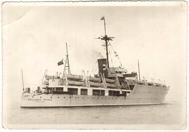 Sunshine and District Historical Society Incorporated
Photograph (1950), The Migrant Ship HELLENIC PRINCE, Copy 27/01/2014 - (Original Post Card circa 1950)
In 1949 the HELLENIC PRINCE with its 3 hospitals, 2 cinemas, and air conditioned accommodation was chartered by the International Refugee Organisation to transport displaced persons from Europe to Australia. Its first trip was to Sydney where it arrived with 1000 passengers on 5 December 1949. On the third trip it left Naples on 23 March 1950, and arrived in Fremantle on 20 April 1950, and in Melbourne on 25 April 1950. The men and women were separated for the voyage with my father sleeping on a hammock in a large room with other men, while my mother, my brother, and I had bunks in a shared cabin. On board were displaced persons ex Bagnoli Camp Italy, some of whom later built their bungalows on the grassy and rocky paddocks near Sunshine Victoria, and began to establish a new life in a new country. A few of the families that arrived on the third trip and purchased land in the Dunkeld Ave - Sandford Ave area of North Sunshine (Birmingham Estate) were Janczak, Kolanowicz, Mroz, Pawlak, Rasztabiga, Skrobalak, Szydlowski, Witkowski, and Zielinski. Some friends settled elsewhere in Sunshine. The family Tabaka went to West Sunshine just over the Derby Rd Bridge, while the family Wojcik went to Ardeer. The ship first started service in 1929 for the Royal Australian Navy as the HMAS ALBATROSS. It had a standard displacement of 4,800 tons and was 443 feet 7 inches (135.2 metres) long, and its top speed during trials reached 22 knots (41 km/hr). It was built at Cockatoo Island Dockyard as Australia's first Aircraft Carrier (seaplanes), but the aircraft that it was designed for were retired just before the ship went into service. A new plane specifically designed to work with the Albatross began operations after the ship was decommissioned in 1933, and placed into reserve in Sydney Harbour. Seaplanes continued to operate from the anchored ship. (Click on the Link 'HMAS Albatross (1)' situated above the Object Registration number to view pictures of the HMAS Albatross on the Navy web site). In 1938 the ship was recommissioned and transferred to the Royal Navy as part payment for the light cruiser Hobart. The ship then did military service for the Royal Navy during World War 2. It did patrol and escort duties in the southern Atlantic, and from mid 1942 in the Indian Ocean. By early 1944 the ship was converted so that it could repair landing craft and other support vessels off Sword and Juno beaches. The ship managed to return 132 craft into service and to save 79 others from total loss. On 11 August 1944 Albatross was torpedoed with the loss of either 50 or 66 personnel, but was able to be towed back to Portsmouth. After repairs she did a short service as a minesweeper depot ship, and following that was placed into reserve on 3 August 1945. In August 1946 the ship was sold for commercial use but the plans to convert it into a luxury liner or a floating cabaret fell through. The ship was again sold on 14 November 1948 to the British-Greek Yannoulatos Group, who renamed it HELLENIC PRINCE in recognition of the birth of Prince Charles and his Greek heritage. After conversion into a passenger ship the Hellenic Prince made several trips to Australia transporting displaced persons, however apparently not all trips were pleasant for the passengers. In the on board newsletter 'Kangaroo' dated 5 January 1951, the ship's master P. C. King expressed his indignation about the behaviour of passengers and made accusations of mutiny. According to some immigrants the conditions were appalling and overcrowded with 1200 passengers. Passengers were supposedly required to work and were paid with Woodbine cigarettes. The drinking water ran out, the freezer broke down, and fresh food that was brought on board went to the crew. Sea sickness was rife because the ship was rarely level due to malfunctioning pumps. (The newsletter 'Kangaroo' can be viewed at the Museum Victoria web site by clicking the Link 'Newsletter - Kangaroo'). In 1953 during the Mau Mau uprising the Hellenic Prince was used to transport troops to Kenya, and in 1954 the ship came to an end in a scrap yard at Hong Kong. THE ABOVE INFORMATION WAS COMPILED FROM; (1) http://en.wikipedia.org/wiki/HMAS_Albatross_(1928) (accessed 11/2/2013), (2) An article by Graeme Andrews found at http://www.afloat.com.au/afloat-magazine/2011/july-2011/The_boat_people_of_the _forties_and_fifties#.UuYY6ou4apo (accessed 27/1/14), (3) http://museumvictoria.com.au/collections/items/273166/newsletter-kangaroo-hellenic-prince-5-jan-1951 (accessed 27/1/14), (4) National Archive search starting at; www.naa.gov.au/collection/search/index.aspx (accessed 27/1/14), (5) http://www.flickr.com/photos/41311545@N05/3864781978 (accessed 29/1/14). Hellenic Prince has a significance to Sunshine Victoria because some of the displaced people from Europe, who arrived in Melbourne on Anzac Day 1950, were among the first people to settle in the grassy and rocky paddock areas of North Sunshine. These settlers established a residential suburban area out of the paddocks. In those early days there were no services and the planned roads were basically just drawings on a map. The ship is also significant because it was named in recognition of the birth of Prince Charles. In the ship's former life as the HMAS Albatross the significance is that it was built in Australia as our country's first Aircraft Carrier (seaplanes).New photograph made from a scanned copy of a circa 1950 Post Card featuring the ship on calm water.Hellenic Prince / Hong Konghellenic prince, migrant ship, displaced persons, refugees, international refugee organisation, bagnoli camp, hmas albatross, yannoulatos group -
 Bendigo Historical Society Inc.
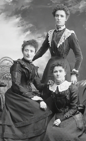
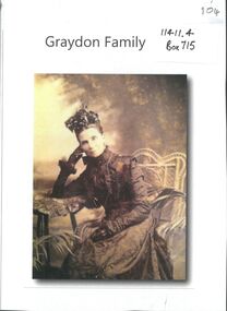
Photograph - Graydon and Richardson Families in Bendigo
Charles Wallace Gordon Graydon the First came out to Victoria on the S.S. Almora, the same ship on which Eliza Richardson and her family arrived on New Years Day 1875. Evidently C.W.G.G.1st. must have retained fond memories of a young fourteen-year-old girl named Elizabeth Richardson who travelled from Scotland with her mother and family (her father had arrived earlier) because three years later at Kyneton they were married. It was December 26th 1860, and Elizabeth was just seventeen. As the bridegroom’s age is written as 24 years on the wedding certificate, he certainly must have been more than eighteen when he sailed on the "Almora" in 1856. The newly married couple went to live at Taradale, Victoria, and they made a good life for themselves in that town which had then a thriving gold mine. They lived in a large two-storied house in Survey Paddock, and it was there that four daughters - Susan Emily (1861-1906), Elizabeth Constance (1863-1945), Amelia Amy (1865 -1952, Ada Mary Maude (1867-1901), and one son Newenham Edward Eustace (1869-1945) named after his Irish Grandfather, were born. On his wedding certificate C.W.G. Graydon, is described as a foreman. His father-in-law, Robert Richardson was employed as a time-keeper on the Melbourne to Bendigo Railway works, and he and his family lived first in Prahran, then Kyneton, and then Taradale. Perhaps Charles Graydon worked on the railway with him. In Taradale however, he worked for a gold mining company in a surveying capacity. C.W.G.G.1st was to become Shire President of the Shire of Metcalfe. That particular year the Graydon Family entertained the visiting English cricket Eleven at their home in Taradale. He was certainly regarded as an important man in the district when he was requested by a great number of the residents to nominate for the Legislative Assembly election. About 1876 the Graydons left Taradale, and went to live at Sandhurst, now Bendigo, at Barkly Place East. The Richardsons had also left Taradale to go into the grocery business in the same town. Charles Wallace Gordon Graydon the First became a legal manager of mines, and a well-known and popular resident. Sad to say he became ill with a lung infection, and on June 4th. 1885 he died, and was buried at Sandhurst, now Bendigo Cemetery, Back Creek Rd. Eliza Richardson's brother was Mr. James Richardson, the well-known grocer, of Pall Mall and Golden-square, who died at his residence, "Balgownie," Short street, on Thursday 22 Jan 1914. James Richardson was a native of Scotland. He was born at Glasgow in1849 and was only eight years of age when his parents sailed for Australia in the ship Balmoral. The family arrived in Melbourne in 1857 and went to Taradale, where Mr. Richardson, senr., acted as inspector of works during the construction of the Taradale Viaduct. James Richardson, who had commenced his educationin Glasgow, attended school at Taradale until the family removed to Bendigo at the time the railway was being built from Bendigo to Echuca. The contractors for this work engaged Mr Richardson, senr., as their timekeeper. When he left school James Richardson applied himself to learn the grocery business, and he gained a thorough knowledge of it with different employers at Bendigo, Taradale, and Daylesford. In 1872 he opened a grocery store on his own account in High-Street, Bendigo, but within a few months he had the great misfortune to be burnt out. The fire originated in an adjoining building early one morning and both places were burnt to the ground. In spite of his loss, Mr. Richardson was not discouraged, for he soon made another start. His trade improved and he extended his business, opening the Eclipse Cash Store at Golden Square. A little later another branch was opened at the Oddfellows' Hall, and subsequently this business was transferred to the Eureka Cash Store, in Pall Mall, which was the head depot. In addition to the retail trade, Mr. Richardson had, for many years carried on an extensive wholesale business with the Northern District, and had made a specialty of fodder seeds. James was a man of probity and sincerity in business, and as a citizen he was highly esteemed and respected. He was a prominent member of the Bendigo Caledonian Society in the earlier days of his citizenship. He was a staunch member of St Andrew's Presbyterian Church, and was a member of the board of management. In the Easter Fair procession, Mr Richardson's display was always a prominent and attractive one. Mr. Richardson was a member of the Masonic Order, and was a life member of the Bendigo Art Gallery and the old Mechanics Institute. He was married at Daylesford in 1871. Mr James Richardson was interred in the Presbyterian section of the Bendigo Cemetery.Digital Image. Copy of photograph of three of the four Graydon girls. Ada, Lizzie and Amelia Graydon. B&W photo of three women - two seated and one standing - Studio portrait.Lizzie (Elizabeth Constance 1863-1945) standing. Amelia (Amelia Amy 1865 - 1952) Seated on right. Ada (Ada Mary Maude 1867-1901) seated left.graydon girls., graydon collection, graydon richardson, james richardson grocer, bendigo history -
 Bendigo Historical Society Inc.
Photograph - GRAYDON COLLECTION: FAMILY PHOTOGRAPHS
Charles Wallace Gordon Graydon the First came out to Victoria on the S.S. Almora, the same ship on which Eliza Richardson and her family arrived on New Years Day 1875. Evidently C.W.G.G.1st. must have retained fond memories of a young fourteen-year-old girl named Elizabeth Richardson who travelled from Scotland with her mother and family (her father had arrived earlier) because three years later at Kyneton they were married. It was December 26th 1860, and Elizabeth was just seventeen. As the bridegroom’s age is written as 24 years on the wedding certificate, he certainly must have been more than eighteen when he sailed on the "Almora" in 1856. The newly married couple went to live at Taradale, Victoria, and they made a good life for themselves in that town which had then a thriving gold mine. They lived in a large two-storied house in Survey Paddock, and it was there that four daughters - Susan Emily (1861-1906), Elizabeth Constance (1863-1945), Amelia Amy (1865 -1952, Ada Mary Maude (1867-1901), and one son Newenham Edward Eustace (1869-1945) named after his Irish Grandfather, were born. On his wedding certificate C.W.G. Graydon, is described as a foreman. His father-in-law, Robert Richardson was employed as a time-keeper on the Melbourne to Bendigo Railway works, and he and his family lived first in Prahran, then Kyneton, and then Taradale. Perhaps Charles Graydon worked on the railway with him. In Taradale however, he worked for a gold mining company in a surveying capacity. C.W.G.G.1st was to become Shire President of the Shire of Metcalfe. That particular year the Graydon Family entertained the visiting English cricket Eleven at their home in Taradale. He was certainly regarded as an important man in the district when he was requested by a great number of the residents to nominate for the Legislative Assembly election. About 1876 the Graydons left Taradale, and went to live at Sandhurst, now Bendigo, at Barkly Place East. The Richardsons had also left Taradale to go into the grocery business in the same town. Charles Wallace Gordon Graydon the First became a legal manager of mines, and a well-known and popular resident. Sad to say he became ill with a lung infection, and on June 4th. 1885 he died, and was buried at Sandhurst, now Bendigo Cemetery, Back Creek Rd. Eliza Richardson's brother was Mr. James Richardson, the well-known grocer, of Pall Mall and Golden-square, who died at his residence, "Balgownie," Short street, on Thursday 22 Jan 1914. James Richardson was a native of Scotland. He was born at Glasgow in1849 and was only eight years of age when his parents sailed for Australia in the ship Balmoral. The family arrived in Melbourne in 1857 and went to Taradale, where Mr. Richardson, senr., acted as inspector of works during the construction of the Taradale Viaduct. James Richardson, who had commenced his educationin Glasgow, attended school at Taradale until the family removed to Bendigo at the time the railway was being built from Bendigo to Echuca. The contractors for this work engaged Mr Richardson, senr., as their timekeeper. When he left school James Richardson applied himself to learn the grocery business, and he gained a thorough knowledge of it with different employers at Bendigo, Taradale, and Daylesford. In 1872 he opened a grocery store on his own account in High-Street, Bendigo, but within a few months he had the great misfortune to be burnt out. The fire originated in an adjoining building early one morning and both places were burnt to the ground. In spite of his loss, Mr. Richardson was not discouraged, for he soon made another start. His trade improved and he extended his business, opening the Eclipse Cash Store at Golden Square. A little later another branch was opened at the Oddfellows' Hall, and subsequently this business was transferred to the Eureka Cash Store, in Pall Mall, which was the head depot. In addition to the retail trade, Mr. Richardson had, for many years carried on an extensive wholesale business with the Northern District, and had made a specialty of fodder seeds. James was a man of probity and sincerity in business, and as a citizen he was highly esteemed and respected. He was a prominent member of the Bendigo Caledonian Society in the earlier days of his citizenship. He was a staunch member of St Andrew's Presbyterian Church, and was a member of the board of management. In the Easter Fair procession, Mr Richardson's display was always a prominent and attractive one. Mr. Richardson was a member of the Masonic Order, and was a life member of the Bendigo Art Gallery and the old Mechanics Institute. He was married at Daylesford in 1871. Mr James Richardson was interred in the Presbyterian section of the Bendigo Cemetery.A selection of black and white Graydon and Richardson family photographs taken by Bendigo photographers. All photos unnamed. Mounted as Cabinet cards. Photographers - D. Mendelfson, Bartlett Bros., The Studio - Chuck, Eden Society Studios, Alan Spicer, R. Bloomfield Rees,graydon, richardson, cabinet card -
 Bendigo Historical Society Inc.
Photograph - GRAYDON COLLECTION: FAMILY PHOTOGRAPHS
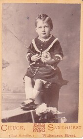
Charles Wallace Gordon Graydon the First came out to Victoria on the S.S. Almora, the same ship on which Eliza Richardson and her family arrived on New Years Day 1875. Evidently C.W.G.G.1st. must have retained fond memories of a young fourteen-year-old girl named Elizabeth Richardson who travelled from Scotland with her mother and family (her father had arrived earlier) because three years later at Kyneton they were married. It was December 26th 1860, and Elizabeth was just seventeen. As the bridegroom’s age is written as 24 years on the wedding certificate, he certainly must have been more than eighteen when he sailed on the "Almora" in 1856. The newly married couple went to live at Taradale, Victoria, and they made a good life for themselves in that town which had then a thriving gold mine. They lived in a large two-storied house in Survey Paddock, and it was there that four daughters - Susan Emily (1861-1906), Elizabeth Constance (1863-1945), Amelia Amy (1865 -1952, Ada Mary Maude (1867-1901), and one son Newenham Edward Eustace (1869-1945) named after his Irish Grandfather, were born. On his wedding certificate C.W.G. Graydon, is described as a foreman. His father-in-law, Robert Richardson was employed as a time-keeper on the Melbourne to Bendigo Railway works, and he and his family lived first in Prahran, then Kyneton, and then Taradale. Perhaps Charles Graydon worked on the railway with him. In Taradale however, he worked for a gold mining company in a surveying capacity. C.W.G.G.1st was to become Shire President of the Shire of Metcalfe. That particular year the Graydon Family entertained the visiting English cricket Eleven at their home in Taradale. He was certainly regarded as an important man in the district when he was requested by a great number of the residents to nominate for the Legislative Assembly election. About 1876 the Graydons left Taradale, and went to live at Sandhurst, now Bendigo, at Barkly Place East. The Richardsons had also left Taradale to go into the grocery business in the same town. Charles Wallace Gordon Graydon the First became a legal manager of mines, and a well-known and popular resident. Sad to say he became ill with a lung infection, and on June 4th. 1885 he died, and was buried at Sandhurst, now Bendigo Cemetery, Back Creek Rd. Eliza Richardson's brother was Mr. James Richardson, the well-known grocer, of Pall Mall and Golden-square, who died at his residence, "Balgownie," Short street, on Thursday 22 Jan 1914. James Richardson was a native of Scotland. He was born at Glasgow in1849 and was only eight years of age when his parents sailed for Australia in the ship Balmoral. The family arrived in Melbourne in 1857 and went to Taradale, where Mr. Richardson, senr., acted as inspector of works during the construction of the Taradale Viaduct. James Richardson, who had commenced his educationin Glasgow, attended school at Taradale until the family removed to Bendigo at the time the railway was being built from Bendigo to Echuca. The contractors for this work engaged Mr Richardson, senr., as their timekeeper. When he left school James Richardson applied himself to learn the grocery business, and he gained a thorough knowledge of it with different employers at Bendigo, Taradale, and Daylesford. In 1872 he opened a grocery store on his own account in High-Street, Bendigo, but within a few months he had the great misfortune to be burnt out. The fire originated in an adjoining building early one morning and both places were burnt to the ground. In spite of his loss, Mr. Richardson was not discouraged, for he soon made another start. His trade improved and he extended his business, opening the Eclipse Cash Store at Golden Square. A little later another branch was opened at the Oddfellows' Hall, and subsequently this business was transferred to the Eureka Cash Store, in Pall Mall, which was the head depot. In addition to the retail trade, Mr. Richardson had, for many years carried on an extensive wholesale business with the Northern District, and had made a specialty of fodder seeds. James was a man of probity and sincerity in business, and as a citizen he was highly esteemed and respected. He was a prominent member of the Bendigo Caledonian Society in the earlier days of his citizenship. He was a staunch member of St Andrew's Presbyterian Church, and was a member of the board of management. In the Easter Fair procession, Mr Richardson's display was always a prominent and attractive one. Mr. Richardson was a member of the Masonic Order, and was a life member of the Bendigo Art Gallery and the old Mechanics Institute. He was married at Daylesford in 1871. Mr James Richardson was interred in the Presbyterian section of the Bendigo Cemetery.Seventeen black and white Graydon and Richardson family photographs taken by Bendigo photographers. All photos unnamed. Mounted as Cartes de Visite. Photographers - The Studio - Chuck, , M. Bent, F. de Kock and Co., N. White, Bartlett Bros., Chevalier.graydon, richardson, carte de visite -
 Bendigo Historical Society Inc.
Photograph - GRAYDON COLLECTION: FAMILY PHOTOGRAPHS
Charles Wallace Gordon Graydon the First came out to Victoria on the S.S. Almora, the same ship on which Eliza Richardson and her family arrived on New Years Day 1875. Evidently C.W.G.G.1st. must have retained fond memories of a young fourteen-year-old girl named Elizabeth Richardson who travelled from Scotland with her mother and family (her father had arrived earlier) because three years later at Kyneton they were married. It was December 26th 1860, and Elizabeth was just seventeen. As the bridegroom’s age is written as 24 years on the wedding certificate, he certainly must have been more than eighteen when he sailed on the "Almora" in 1856. The newly married couple went to live at Taradale, Victoria, and they made a good life for themselves in that town which had then a thriving gold mine. They lived in a large two-storied house in Survey Paddock, and it was there that four daughters - Susan Emily (1861-1906), Elizabeth Constance (1863-1945), Amelia Amy (1865 -1952, Ada Mary Maude (1867-1901), and one son Newenham Edward Eustace (1869-1945) named after his Irish Grandfather, were born. On his wedding certificate C.W.G. Graydon, is described as a foreman. His father-in-law, Robert Richardson was employed as a time-keeper on the Melbourne to Bendigo Railway works, and he and his family lived first in Prahran, then Kyneton, and then Taradale. Perhaps Charles Graydon worked on the railway with him. In Taradale however, he worked for a gold mining company in a surveying capacity. C.W.G.G.1st was to become Shire President of the Shire of Metcalfe. That particular year the Graydon Family entertained the visiting English cricket Eleven at their home in Taradale. He was certainly regarded as an important man in the district when he was requested by a great number of the residents to nominate for the Legislative Assembly election. About 1876 the Graydons left Taradale, and went to live at Sandhurst, now Bendigo, at Barkly Place East. The Richardsons had also left Taradale to go into the grocery business in the same town. Charles Wallace Gordon Graydon the First became a legal manager of mines, and a well-known and popular resident. Sad to say he became ill with a lung infection, and on June 4th. 1885 he died, and was buried at Sandhurst, now Bendigo Cemetery, Back Creek Rd. Eliza Richardson's brother was Mr. James Richardson, the well-known grocer, of Pall Mall and Golden-square, who died at his residence, "Balgownie," Short street, on Thursday 22 Jan 1914. James Richardson was a native of Scotland. He was born at Glasgow in1849 and was only eight years of age when his parents sailed for Australia in the ship Balmoral. The family arrived in Melbourne in 1857 and went to Taradale, where Mr. Richardson, senr., acted as inspector of works during the construction of the Taradale Viaduct. James Richardson, who had commenced his educationin Glasgow, attended school at Taradale until the family removed to Bendigo at the time the railway was being built from Bendigo to Echuca. The contractors for this work engaged Mr Richardson, senr., as their timekeeper. When he left school James Richardson applied himself to learn the grocery business, and he gained a thorough knowledge of it with different employers at Bendigo, Taradale, and Daylesford. In 1872 he opened a grocery store on his own account in High-Street, Bendigo, but within a few months he had the great misfortune to be burnt out. The fire originated in an adjoining building early one morning and both places were burnt to the ground. In spite of his loss, Mr. Richardson was not discouraged, for he soon made another start. His trade improved and he extended his business, opening the Eclipse Cash Store at Golden Square. A little later another branch was opened at the Oddfellows' Hall, and subsequently this business was transferred to the Eureka Cash Store, in Pall Mall, which was the head depot. In addition to the retail trade, Mr. Richardson had, for many years carried on an extensive wholesale business with the Northern District, and had made a specialty of fodder seeds. James was a man of probity and sincerity in business, and as a citizen he was highly esteemed and respected. He was a prominent member of the Bendigo Caledonian Society in the earlier days of his citizenship. He was a staunch member of St Andrew's Presbyterian Church, and was a member of the board of management. In the Easter Fair procession, Mr Richardson's display was always a prominent and attractive one. Mr. Richardson was a member of the Masonic Order, and was a life member of the Bendigo Art Gallery and the old Mechanics Institute. He was married at Daylesford in 1871. Mr James Richardson was interred in the Presbyterian section of the Bendigo Cemetery.A selection of Graydon and Richardson family photographs taken by Bendigo photograpers. all photos unnamed.photograph, person, graydon and richardson families. -
 Bendigo Historical Society Inc.
Mixed media - GRAYDON COLLECTION: FAMILY PHOTOGRAPHS and NOTES (See ITEM 11411)
Charles Wallace Gordon Graydon the First came out to Victoria on the S.S. Almora, the same ship on which Eliza Richardson and her family arrived on New Years Day 1875. Evidently C.W.G.G.1st. must have retained fond memories of a young fourteen-year-old girl named Elizabeth Richardson who travelled from Scotland with her mother and family (her father had arrived earlier) because three years later at Kyneton they were married. It was December 26th, 1860, and Elizabeth was just seventeen. As the bridegroom’s age is written as 24 years on the wedding certificate, he certainly must have been more than eighteen when he sailed on the "Almora" in 1856. The newly married couple went to live at Taradale, Victoria, and they made a good life for themselves in that town which had then a thriving gold mine. They lived in a large two-storied house in Survey Paddock, and it was there that four daughters - Susan Emily (1861-1906), Elizabeth Constance (1863-1945), Amelia Amy (1865 -1952, Ada Mary Maude (1867-1901), and one son Newenham Edward Eustace (1869-1945) named after his Irish Grandfather, were born. On his wedding certificate C.W.G. Graydon, is described as a foreman. His father-in-law, Robert Richardson was employed as a timekeeper on the Melbourne to Bendigo Railway works, and he and his family lived first in Prahran, then Kyneton, and then Taradale. Perhaps Charles Graydon worked on the railway with him. In Taradale however, he worked for a gold mining company in a surveying capacity. C.W.G.G.1st was to become Shire President of the Shire of Metcalfe. That particular year the Graydon Family entertained the visiting English cricket Eleven at their home in Taradale. He was certainly regarded as an important man in the district when he was requested by a great number of the residents to nominate for the Legislative Assembly election. About 1876 the Graydons left Taradale, and went to live at Sandhurst, now Bendigo, at Barkly Place East. The Richardsons had also left Taradale to go into the grocery business in the same town. Charles Wallace Gordon Graydon the First became a legal manager of mines, and a well-known and popular resident. Sad to say he became ill with a lung infection, and on June 4th. 1885 he died, and was buried at Sandhurst, now Bendigo Cemetery, Back Creek Rd. Eliza Richardson's brother was Mr. James Richardson, the well-known grocer, of Pall Mall and Golden-square, who died at his residence, "Balgownie," Short Street, on Thursday 22 Jan 1914. James Richardson was a native of Scotland. He was born at Glasgow in1849 and was only eight years of age when his parents sailed for Australia in the ship Balmoral. The family arrived in Melbourne in 1857 and went to Taradale, where Mr. Richardson, senior., acted as inspector of works during the construction of the Taradale Viaduct. James Richardson, who had commenced his education in Glasgow, attended school at Taradale until the family removed to Bendigo at the time the railway was being built from Bendigo to Echuca. The contractors for this work engaged Mr. Richardson, as their timekeeper. When he left school James Richardson applied himself to learn the grocery business, and he gained a thorough knowledge of it with different employers at Bendigo, Taradale, and Daylesford. In 1872 he opened a grocery store on his own account in High-Street, Bendigo, but within a few months he had the great misfortune to be burnt out. The fire originated in an adjoining building early one morning and both places were burnt to the ground. In spite of his loss, Mr. Richardson was not discouraged, for he soon made another start. His trade improved and he extended his business, opening the Eclipse Cash Store at Golden Square. A little later another branch was opened at the Oddfellows' Hall, and subsequently this business was transferred to the Eureka Cash Store, in Pall Mall, which was the head depot. In addition to the retail trade, Mr. Richardson had, for many years carried on an extensive wholesale business with the Northern District and had made a specialty of fodder seeds. James was a man of probity and sincerity in business, and as a citizen he was highly esteemed and respected. He was a prominent member of the Bendigo Caledonian Society in the earlier days of his citizenship. He was a staunch member of St Andrew's Presbyterian Church, and was a member of the board of management. In the Easter Fair procession, Mr. Richardson's display was always a prominent and attractive one. Mr. Richardson was a member of the Masonic Order and was a life member of the Bendigo Art Gallery and the old Mechanics Institute. He was married at Daylesford in 1871. Mr James Richardson was interred in the Presbyterian section of the Bendigo Cemetery.DVD A selection of Graydon and Richardson family photographs taken by Bendigo photographers, and family history notesphotograph, person, graydon and richardson families. -
 Ringwood and District Historical Society
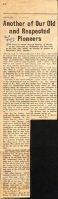
Newspaper, The Mail, Obituary - Joseph Richard Sanders - Old and Respected Pioneer Ringwood 1959 from the Ringwood Mail, 1959
The article was contributed by J.K.McCaskill, JP. a mayor of Ringwood in the years between 1924-1951.The Sanders family came from England and are mentioned in the book "Ringwood a Place of Many Eagles" by Hugh AndersonObituary from The Ringwood Mail of Joseph Richard Sanders of 18, Wantirna Road, Ringwood, aged 87 years. He came from a family who were early pioneers of Ringwood. he was born in Collingwood but schooled in Ringwood, married and brought up his family in Ringwood. He lived at 18, Wantirna Road .The article was contributed by J.K.McCaskill, JP. a mayor of Ringwood in the years between 1924-1951.Transcript: "The death occurred of Joseph Richard Sanders, 18 Wantirna Rd, Ringwood, on Wednesday, 21st October 1959, in his 87th year, marks the passing of another of Ringwood’s early pioneers. He was born in Collingwood in August 1873 and came to Ringwood with his parents when 15 months old. They made their home on land on what is now known as Jubilee Park (Fuller particulars of this Park will appear in ‘The Mail’ at a later date, also reference will be made to Wantirna Rd, in the early days it was known as West Prussia Rd). Joe went to the school held in the old homestead and orchard of Mr. Mills, just through the Heatherdale Road railway gates. He remembered many of the scholars, some of the boys and girls had to walk three and four miles to school through rough scrub paddocks in all kinds of weather. During the lunch hour a few of the boys generally went to the creek to fish for eels and would be late in getting back to school, greatly to the annoyance of the teacher. One day the fishing was good, and the boys rather reluctantly returned to the school late as usual. The teacher was furious and made them stand in front of the class but before inflicting punishment she called out to one of the boys to throw out that dirty bag he was holding. The lad gave the bag a shake and out wriggled a snake. There was immediately a general stampede from the classroom, led by the teacher. The school was closed for the rest of the afternoon. Another incident related to a few tramps who after the scholars had all gone home, generally camped for the night in an old back room in the homestead. One of the boys put a little gunpowder in this old fireplace and when the tramps lit the fire to boil their billies the old chimney and part of the old wall just collapsed. Joe, after leaving school, worked around the district for some time and later left Ringwood to live in other suburbs. He at one time was employed at the Aust Glass Works, and later as a carpenter worked on building the dome of the Railway Station at Flinders St. He married a Miss E. M. Wood in 1901 at Richmond and a few years afterwards returned to Ringwood and resided at No. 18 Wantirna Rd., where he reared a family' of three girls (Alice, Ethel, Joyce) and two boys (Robert and Joe). Joe recalled many interesting events of earlier years, such as the duplication of the railway line, and the cutting back of the embankment at the Goods Shed, the earth being used to heighten up the railway bridge over Wantirna Rd. The brickworks at Ringwood East and reference to early land surveys, the using of the heavy chain links before the use of the theodolite became general, and the many neighbours and friends whom he knew. He was interested in local public affairs and was fond of fishing. He proved himself a good citizen and was highly respected and esteemed throughout the district, and so another old pioneer passes on." (Contributed by J. K. McCaskill, J.P.) RM 19 Nov 1959 -
Glen Eira Historical Society
Photograph - Elsternwick
... Paddocks ...This file contains three items. Photocopied and three page retyped article, undated c.1930s and source unknown from Real Estate Agent Philippe Batters 03/09/1997. Three page document from Keith James Smith, undated, on research on Elsternwick and Glen Huntly Road shops and traders. Three articles from THE AGE 13/05/2000 and 15-16/02/2013 and MELB BAYSIDE WEEKLY 03/11/2010 giving snap shots of Elsternwick housing and facts.batters philippe, real estate agents, elsternwick, paddocks, glen huntly road, walter kelly, elsternwick park, slaughter yards, glen eira roads, point ormond, glenhuntly railway station, nepean highway, grange road, holdsworth’s jewellers, staniland grove, coles store, shops, orrong road, fosseys, hattams mensware, woolworths, dalgarnos crockery and kitchenware, chapmans gifts, garth’s shoe store, garth jack, allen’s furniture and auction rooms, elsternwick market, adam’s cakes, mr. green’s pet shop, turner mr., grocer shop, moores lendring library, hopetown gardens, gardens, jack hatheralls butchershop, butchers, chinese laundry, chinese community, laundries, mr. & mrs. darbyshires milkbar, st. johns church, kooyong road, hasseles garage, garages, royal parade, glenhuntly, camden, hawthorn road, blacksmiths, camden town, dolls hospital, caulfield state school 773, independent picture, theatres, camden theatre, southern indoor bowl centre, larch street, montessorie school, collins milk bar, milk bars, collins lin, hartrick miss, armond mr., lennie mr., rothells sausage factory, north road, red bus service transport, furlonger miss, dance studio, moran and cato grocery, cato family, newsagent, tozer brook, furniture store, green gables american style soda fountain and milk bar, hoyts renown theatre, state savings bank, riddell parade, clarence street, aileen avenue, smith keith james, camden town, sports club, peer gary, gary peer & associates, brukarz jack, ray white real estate, real estate agents, classic cinema theatres, st. george’s road, elizabeth street, allison road, gladstone park, myrtle street, victoria street, caulfield, st kilda east, lisbon house, orrong road, house names, rippon lea estate, caulfield south, carnegie, gordon street, carre street, main street, clarence street, elsternwick club, jewish holocaust museum, daily planet, brothels, wesley college, elsternwick primary, st. joseph’s primary, scholem aleichen college, liebler yavneh, hopetoun gardens, harleston park -
Bendigo Historical Society Inc.
Document - ROYAL PRINCESS THEATRE COLLECTION: MAJORIE IN WONDERLAND, 12 Aug 1916
Royal Princess Theatre - Majorie in Wonderland. Saturday, 12 August, 1916. Price of Program, One Penny. Australian Children's Pantomime. Matinee Performance. In Aid of Fruit and Vegtable Fund For Our Soldiers in The Trenches. Produced by Miss Girlie Mackay. Children's Vocal Training by Madame Rossow. Dialogue by Miss Eileen O'Keefe. Musical Director, Mr Stanley Upton. Stage Manager, Mr J Dunphy. Lighting Effects Mr W Wenborn. Theatre kindly lent by W Crowley, Esq. Hon. Sec., Norman Howell. Prologue. The curtain rises showing the flowers asleep. The fairies, summoned by daylight, entre and sing, awakening the flowers, and leave. Then Puck entres, followed by the Blue Wrens, singing, and after them the Bunnies, who are all . . . Sale of Sweets supervised by Miss Nita Weller and Assistants. Novelties by Mrs Julius Cohn. Dresses designed and made by Mrs McQuie, Mrs Marc Cohn, Miss Lena Weller, and Miss Girlie Mackay, assisted by Mrs Balsillie, Mrs Ralph Ross. Mrs Robert Makayand the Misses Gladys McQuie, Norma Moorhead, Carola Iser, and Hilda Meurer. Program: Songs sung throught Performance. Act I. 1 Chorus-Fairy Song. 2 'Bunnies' Adventure' by the Bunnies. 3 Chorus-Holiday Song. 4 Bell Bird Duett-Jean & Jim Walker. 5 Sailor's Hornpipe-Crissie Cravino. 6 'Marjorie Sunbeam'-Myrtle Glanville. 7 'As I went o'er the Paddock'-Jean Walker. 8 Chorus'Billy Tea. 9 Song-'Possum'-Bertie Barkell. 10 'Bogie Man'-Stella Coghlan. 11 'Kookooburra'-Mel Wearne. 12 Chorus-'Winter Bells'. Act II. 1 Chorus-'Autumn Winds'. 2 'Stay Little Wave'-Jean Walker. 3 'Southern Cross'-Rose Murphy. 4 Song-'Kangaroo'-Brownies. 5 'Pixie Man'-Ruthie Murphy. 6 Chorus-'Wattle'. 7 'Grow Little Mushroom'-Stella Cook. 8 'Cooee'-Myrtle Glanville & Marie Hamilton. 9 Butterfly Dance-Sheila Shannon.10 'King Billy & Black Mary'-Ken McQuie. 11 Boomerang Song-Ken McQuie. 12 Final Chorus-'To the Fairies', 'Good Night'. God Bless Our Splendid Men. Cast of Characters:Marjorie & Jean Walker, Myrtle Glanville, Ruthie Murphy, Marie Hamilton, Thelma Thomas, Stella Coghlan, Jim Walker, Jim Long, Bertie Barkell. Fairies:-Mary Hunter, Lily Brown, Una Grelis, Biddie Bulley, Rosa Dyring, Ellie Colcough, Ida Collins. Puck:-Una Leggo. Butterfly:-Sheila Shannon. Brownies:-Tom Green, Douglas McQuie, Hunphrey, Gill, Mel Wearne, Laurence Skewes. Aboriginal:-Ken Mquie. Frog:-Sid Whitelaw. Native Bear:-Ken Moore. Blue Wrens:- Alma Jorgenson, Doris Reed, Geoff Schultz, Jean Cahill. Flowers. Orchids:- Joyce Ross, Margaret Long, Dorothy Thomas, Margaret McQuie, Mollie Roberts, Rose Murphy. Pink Gums:-Lorna Weddell, Minnie Hartley, Isola Woodward, Jean Moran, Decima Holtorf, Merle Nagel. Flannel Flowers: Gwen Hunter, Nancy Tatchell, Catherine Green, Mary Rymer, Thelma Cairns, Cecil Gleeson. Poppies:-Lorna Cattran, Alice Murphy, Maisie O'Grady, Eileen Coglan, Alma McWilliams, Jean Miller. Blue Bells:-Mavis Tozer, Vivian Reed, Monnie Fattorini, Gwennie Seely, Alice Evans, Lily O'Conner. Southern Cross:-Eileen Martin, Jean Murdoch, Effie Williams, Verna Mayne, Minnie Hartley, Mollie Martin.Cambridge Press, Print.program, theatre, royal princess theatre, royal princess theatre - majorie in wonderland. 12 august, 1916. program, one penny. australian children's pantomime. matinee performance. in aid of fruit and vegtable fund for our soldiers in the trenches. produced by miss girlie mackay. children's vocal training by madame rossow. dialogue by miss eileen o'keefe. musical director, mr stanley upton. stage manager, mr j dunphy. lighting effects mr w wenborn. theatre lent by w crowley, esq. hon. sec., norman howell. prologue. the curtain rises showing the flowers asleep. the fairies, summoned by daylight, entre and sing, awakening the flowers, and leave. then puck entres, followed by the blue. . . sale of sweets supervised by miss nita weller and assistants. novelties by mrs julius cohn. dresses designed and made by mrs mcquie, mrs marc cohn, miss lena weller, and miss girlie mackay, assisted by mrs balsillie, mrs ralph ross. mrs robert makayand the misses gladys mcquie, norma moorhead, carola iser, and hilda meurer. program: songs sung throught performance. act i. 1 chorus-fairy song. 2 'bunnies' adventure' by the bunnies. 3 chorus-holiday song. 4 bell bird duett-jean & jim walker. 5 sailor's hornpipe-crissie cravino. 6 'marjorie sunbeam'-myrtle glanville. 7 'as i went o'er the paddock'-jean walker. 8 chorus'billy tea. 9 song-'possum'-bertie barkell. 10 'bogie man'-stella coghlan. 11 'kookooburra'-mel wearne. 12 chorus-'winter bells'. act ii. 1 chorus-'autumn winds'. 2 'stay little wave'-jean walker. 3 'southern cross'-rose murphy. 4 song-'kangaroo'-brownies. 5 'pixie man'-ruthie murphy. 6 chorus-'wattle'. 7 'grow little mushroom'-stella cook. 8 'cooee'-myrtle glanville & marie hamilton. 9 butterfly dance-sheila shannon.10 'king billy & black mary'-ken mcquie. 11 boomerang song-ken mcquie. 12 final chorus-'to the fairies', 'good night'. god bless our splendid men. cast of characters:marjorie & jean walker, myrtle glanville, ruthie murphy, marie hamilton, thelma thomas, stella coghlan, jim walker, jim long, bertie barkell. fairies:-mary hunter, lily brown, una grelis, biddie bulley, rosa dyring, ellie colcough, ida collins. puck:-una leggo. butterfly:-sheila shannon. brownies:-tom green, douglas mcquie, hunphrey, gill, mel wearne, laurence skewes. aboriginal:-ken mquie. frog:-sid whitelaw. native bear:-ken moore. blue wrens:- alma jorgenson, doris reed, geoff schultz, jean cahill. flowers. orchids:- joyce ross, margaret long, dorothy thomas, margaret mcquie, mollie roberts, rose murphy. pink gums:-lorna weddell, minnie hartley, isola woodward, jean moran, decima holtorf, merle nagel. flannel flowers: gwen hunter, nancy tatchell, catherine green, mary rymer, thelma cairns, cecil gleeson. poppies:-lorna cattran, alice murphy, maisie o'grady, eileen coglan, alma mcwilliams, jean miller. blue bells:-mavis tozer, vivian reed, monnie fattorini, gwennie seely, alice evans, lily o'conner. southern cross:-eileen martin, jean murdoch, effie williams, verna mayne, minnie hartley, mollie martin. -
 Eltham District Historical Society Inc
Photograph, Hume and Hovell passed here at Seymour 28 Oct 1824, Spring Excursion, Hume and Hovell's 1824 expedition (Part 2), 26 October 1997, 26/10/1997
[article by Diana Bassett-Smith in EDHS Newsletter No. 117, November 1997:] MONUMENT HUNTING THE HUME AND HOVELL WAY - Sunday October 26 1997 dawned bright and very warm. Some twenty-five members, complete with picnic baskets, met outside the Eltham Library awaiting the Cobb and Co. large coach which would be taking us on the second leg of our travels along the route of the early explorers Hume and Hovell. Stephen West was our very good driver for the day. He would be guided around the circuitous route by Russell Yeoman who had made a detailed study, not only of the intended route, but of the story of these two explorers. During the trip Russell regaled us with poetry, quotations from the Journals and the History of the Shire of Seymour, "The New Crossing Place" by Martindale, 1982, (now Mitchell Shire due to the recent amalgamations). We headed towards the Hume Highway via Greensborough and Cooper Street and proceeded north to our first stop, noting on the way Monument Hill in the distance which is near Kilmore and, according to Russell, well worth the effort to visit as the view across the valley is magnificent. Past Sunday Creek Valley, Mt Piper and Mt Disappointment, all traversed and noted and named by them. We passed through Tallarook, then onto Seymour where we took photos of the monument telling us that Hume and Hovell had passed through on the 28th of October 1824. We also deviated down Hume and Hovell Road viewing deer and emu farming and the Bellbourie property now a sanctuary. Leaving Seymour behind we travelled up the Avenel Road to the Avenel monument, pyramidal in design of four reducing square blocks with a sharply pointed peak, erected in 1924 in memory of the 1824 exploration. The day was warming up and the countryside showing the dryness of the current drought. A parallel note had been made in their journal too of 1824 of the drought appearance of the country they were traversing. At Seven Creeks, Euroa we stopped for some minutes to check the monument placed 20th November 1924 to commemorate their passage on the 29th December 1824. More photos. Russell had pointed out the abrupt termination of the distant ranges which is noted in their journal. The next monument is beside the road at the entrance to Honey Suckle Creek Caravan Park, Violet Town. The squarish shaped monument some eight feet high is topped with a simple steel cross, and was to mark the date of 28th December 1824 and built for the 20th November 1924. By now it was 12.20 and nearly lunchtime as we drove along the Warranbayne Road to Roach's Road, monument hunting without success. Though there is a large, what appears to be an old timber sign which was hard to read, maybe this was the lost monument. In many of the paddocks hay had been cut and baled or was being cut, what a contrast to the rugged country they had passed through which was smoky from the fires of the natives burning off. By 1.00 pm we were at Benalla and pulled up beside the park where abundant beds of roses filled the air with their scent and the smell of barbecued food twitched the nostrils whilst the cheerful sounds of other picnickers could be heard throughout the park. We left the bus and collected up our picnics, dispersed to the various tables and enjoyed the shade from the various European trees. 2.00 pm and we were on the road again driving along the Benalla, Mansfield, Yea road. The Swanpool monument states that they passed four miles south and returned three miles north. Then we stopped at the Barjarg monument which notes that they camped near this spot. It is again a pyramidal monument and this time topped with a steel arrow indicating their route of the 29th November 1824. Half an hour later we came to another monument, again with a steel arrow marker on top and the plaque dated the 2nd of 12th 1824. Erected on the 12th of 12th 1924. "They blazed the way that we might inherit the land." Another square based and needle topped monument appeared at Yarck near Yea and this plaque records the date of 3 December 1824. Near McGuigans Road Russell related that the expedition had lost a dog but it had found them next day, the dog was apparently torn by a kangaroo. A short while later Russell reminded us here of the problems they encountered in crossing the Goulburn River near Molesworth where banks were high, water deep and wide. "Good coat of grass but quite dry due to drought". At Yea we stopped for afternoon tea and raided the last of our picnics and looked at the monument to their journey of 1824, situated at a corner of the gardens near the bowling green. No photo – we were out of film. We returned home via Kinglake West and Whittlesea past the Yan Yean Reservoir, not full. 5.00 pm back at Eltham we emptied out of the bus and everyone, including Joan Cole, collected their things, Joan also had the major souvenir of the day, a large carp she had picked up from the river bank, her cat was in for a great feast. The day was made so interesting by the informed commentary which Russell provided. His background knowledge of the route and nature of the journey could only have come from many hours of reading and driving the area. Thank you to Russell and to everyone who made the day so informative and pleasurable. Colour photographactivities, hume and hovell, monument, seymour -
 Eltham District Historical Society Inc
Photograph, Spring Excursion, Hume and Hovell's 1824 expedition (Part 2), 26 October 1997, 26/10/1997
[article by Diana Bassett-Smith in EDHS Newsletter No. 117, November 1997:] MONUMENT HUNTING THE HUME AND HOVELL WAY - Sunday October 26 1997 dawned bright and very warm. Some twenty-five members, complete with picnic baskets, met outside the Eltham Library awaiting the Cobb and Co. large coach which would be taking us on the second leg of our travels along the route of the early explorers Hume and Hovell. Stephen West was our very good driver for the day. He would be guided around the circuitous route by Russell Yeoman who had made a detailed study, not only of the intended route, but of the story of these two explorers. During the trip Russell regaled us with poetry, quotations from the Journals and the History of the Shire of Seymour, "The New Crossing Place" by Martindale, 1982, (now Mitchell Shire due to the recent amalgamations). We headed towards the Hume Highway via Greensborough and Cooper Street and proceeded north to our first stop, noting on the way Monument Hill in the distance which is near Kilmore and, according to Russell, well worth the effort to visit as the view across the valley is magnificent. Past Sunday Creek Valley, Mt Piper and Mt Disappointment, all traversed and noted and named by them. We passed through Tallarook, then onto Seymour where we took photos of the monument telling us that Hume and Hovell had passed through on the 28th of October 1824. We also deviated down Hume and Hovell Road viewing deer and emu farming and the Bellbourie property now a sanctuary. Leaving Seymour behind we travelled up the Avenel Road to the Avenel monument, pyramidal in design of four reducing square blocks with a sharply pointed peak, erected in 1924 in memory of the 1824 exploration. The day was warming up and the countryside showing the dryness of the current drought. A parallel note had been made in their journal too of 1824 of the drought appearance of the country they were traversing. At Seven Creeks, Euroa we stopped for some minutes to check the monument placed 20th November 1924 to commemorate their passage on the 29th December 1824. More photos. Russell had pointed out the abrupt termination of the distant ranges which is noted in their journal. The next monument is beside the road at the entrance to Honey Suckle Creek Caravan Park, Violet Town. The squarish shaped monument some eight feet high is topped with a simple steel cross, and was to mark the date of 28th December 1824 and built for the 20th November 1924. By now it was 12.20 and nearly lunchtime as we drove along the Warranbayne Road to Roach's Road, monument hunting without success. Though there is a large, what appears to be an old timber sign which was hard to read, maybe this was the lost monument. In many of the paddocks hay had been cut and baled or was being cut, what a contrast to the rugged country they had passed through which was smoky from the fires of the natives burning off. By 1.00 pm we were at Benalla and pulled up beside the park where abundant beds of roses filled the air with their scent and the smell of barbecued food twitched the nostrils whilst the cheerful sounds of other picnickers could be heard throughout the park. We left the bus and collected up our picnics, dispersed to the various tables and enjoyed the shade from the various European trees. 2.00 pm and we were on the road again driving along the Benalla, Mansfield, Yea road. The Swanpool monument states that they passed four miles south and returned three miles north. Then we stopped at the Barjarg monument which notes that they camped near this spot. It is again a pyramidal monument and this time topped with a steel arrow indicating their route of the 29th November 1824. Half an hour later we came to another monument, again with a steel arrow marker on top and the plaque dated the 2nd of 12th 1824. Erected on the 12th of 12th 1924. "They blazed the way that we might inherit the land." Another square based and needle topped monument appeared at Yarck near Yea and this plaque records the date of 3 December 1824. Near McGuigans Road Russell related that the expedition had lost a dog but it had found them next day, the dog was apparently torn by a kangaroo. A short while later Russell reminded us here of the problems they encountered in crossing the Goulburn River near Molesworth where banks were high, water deep and wide. "Good coat of grass but quite dry due to drought". At Yea we stopped for afternoon tea and raided the last of our picnics and looked at the monument to their journey of 1824, situated at a corner of the gardens near the bowling green. No photo – we were out of film. We returned home via Kinglake West and Whittlesea past the Yan Yean Reservoir, not full. 5.00 pm back at Eltham we emptied out of the bus and everyone, including Joan Cole, collected their things, Joan also had the major souvenir of the day, a large carp she had picked up from the river bank, her cat was in for a great feast. The day was made so interesting by the informed commentary which Russell provided. His background knowledge of the route and nature of the journey could only have come from many hours of reading and driving the area. Thank you to Russell and to everyone who made the day so informative and pleasurable. Colour photographactivities, hume and hovell, bridge -
 Eltham District Historical Society Inc
Photograph, Spring Excursion, Hume and Hovell bus tour Stage 2, Seymour, Benalla; 26 Oct 1997, 26/10/1997
MONUMENT HUNTING THE HUME AND HOVELL WAY (Newsletter No. 117, November 1997, by Diana Bassett-Smith) Sunday October 26 1997 dawned bright and very warm. Some twenty-five members, complete with picnic baskets, met outside the Eltham Library awaiting the Cobb and Co. large coach which would be taking us on the second leg of our travels along the route of the early explorers Hume and Hovell. Stephen West was our very good driver for the day. He would be guided around the circuitous route by Russell Yeoman wh9 had made a detailed study, not only of the intended route, but of the story of these two explorers. During the trip Russell regaled us with poetry, quotations from the Journals and the History of the Shire of Seymour, "The New Crossing Place: by Martindale, 1982, (now Mitchell Shire due to the recent amalgamations). We headed towards the Hume Highway via Greensborough and Cooper Street and proceeded north to our first stop, noting on the way Monument Hill in the distance which is near Kilmore and, according to Russell, well worth the effort to visit as the view across the valley is magnificent. Past Sunday Creek Valley, Mt Piper and Mt Disappointment, all traversed and noted and named by them. We passed through Tallarook, then onto Seymour where we took photos of the monument telling us that Hume and Hovell had passed through on the 28th of October 1824. We also deviated down Hume and Hovell Road viewing deer and emu farming and the Bellbourie property now a sanctuary. Leaving Seymour behind we travelled up the Avenel Road to the Avenel monument, pyramidal in design of four reducing square blocks with a sharply pointed peak, erected in 1924 in memory of the 1824 exploration. The day was warming up and the countryside showing the dryness of the current drought. A parallel note had been made in their journal too of 1824 of the drought appearance of the country they were traversing. At Seven Creeks, Euroa we stopped for some minutes to check the monument placed 20th November 1924 to commemorate their passage on the 29th December 1824. More photos. Russell had pointed out the abrupt termination of the distant ranges which is noted in their journal. The next monument is beside the road at the entrance to Honey Suckle Creek Caravan Park, Violet Town. The squarish shaped monument some eight feet high is topped with a simple steel cross, and was to mark the date of 28th December 1824 and built for the 20th November 1924. By now it was 12.20 and nearly lunchtime as we drove along the Warranbayne Road to Roach's Road, monument hunting without success. Though there is a large, what appears to be an old timber sign which was hard to read, maybe this was the lost monument. In many of the paddocks hay had been cut and baled or was being cut, what a contrast to the rugged country they had passed through which was smoky from the fires of the natives burning off By 1.00 pm we were at Benalla and pulled up beside the park where abundant beds of roses filled the air with their scent and the smell of barbecued food twitched the nostrils whilst the cheerful sounds of other picnickers could be heard throughout the park. We left the bus and collected up our picnics, dispersed to the various tables and enjoyed the shade from the various European trees. 2.00 pm and we were on the road again driving along the Benalla, Mansfield, Yea road. The Swanpool monument states that they passed four miles south and returned three miles north. Then we stopped at the Barjarg monument which notes that they camped near this spot. It is again a pyramidal monument and this time topped with a steel arrow indicating their route of the 29th November 1824. Half an hour later we came to another monument, again with a steel arrow marker on top and the plaque dated the 2nd of 12th 1824. Erected on the 12th of 12th 1924. "They blazed the way that we might inherit the land." Another square based and needle topped monument appeared at Yarck near Yea and this plaque records the date of 3 December 1824. Near McGuigans Road Russell related that the expedition had lost a dog but it had found them next day, the dog was apparently torn by a kangaroo. A short while later Russell reminded us here of the problems they encountered in crossing the Goulburn River near Molesworth where banks were high, water deep and wide. "Good coat of grass but quite dry due to drought". At Yea we stopped for afternoon tea and raided the last of our picnics and looked at the monument to their journey of 1824, situated at a corner of the gardens near the bowling green. No photo – we were out of film. We returned home via Kinglake West and Whittlesea past the Yan Yean Reservoir, not full. 5.00 pm back at Eltham we emptied out of the bus and everyone, including Joan Cole, collected their things, Joan also had the major souvenir of the day, a large carp she had picked up from the river bank, her cat was in for a great feast. The day was made so interesting by the informed commentary which Russell provided. His background knowledge of the route and nature of the journey could only have come from many hours of reading and driving the area. Thank you to Russell and to everyone who made the day so informative and pleasurable. Diana Bassett-Smith. Record of the Society's history of activities - Spring 1997 excursionRoll of 35mm colour negative film, 6 stripsFuji 200shire of eltham historical society, activities, pretty hill, seymour, benalla, hume and hovell, monuments -
 Eltham District Historical Society Inc
Photograph, Spring Excursion, Hume and Hovell bus tour Stage 2, Seymour, Benalla; 26 Oct 1997, 26/10/1997
MONUMENT HUNTING THE HUME AND HOVELL WAY (Newsletter No. 117, November 1997, by Diana Bassett-Smith) Sunday October 26 1997 dawned bright and very warm. Some twenty-five members, complete with picnic baskets, met outside the Eltham Library awaiting the Cobb and Co. large coach which would be taking us on the second leg of our travels along the route of the early explorers Hume and Hovell. Stephen West was our very good driver for the day. He would be guided around the circuitous route by Russell Yeoman wh9 had made a detailed study, not only of the intended route, but of the story of these two explorers. During the trip Russell regaled us with poetry, quotations from the Journals and the History of the Shire of Seymour, "The New Crossing Place: by Martindale, 1982, (now Mitchell Shire due to the recent amalgamations). We headed towards the Hume Highway via Greensborough and Cooper Street and proceeded north to our first stop, noting on the way Monument Hill in the distance which is near Kilmore and, according to Russell, well worth the effort to visit as the view across the valley is magnificent. Past Sunday Creek Valley, Mt Piper and Mt Disappointment, all traversed and noted and named by them. We passed through Tallarook, then onto Seymour where we took photos of the monument telling us that Hume and Hovell had passed through on the 28th of October 1824. We also deviated down Hume and Hovell Road viewing deer and emu farming and the Bellbourie property now a sanctuary. Leaving Seymour behind we travelled up the Avenel Road to the Avenel monument, pyramidal in design of four reducing square blocks with a sharply pointed peak, erected in 1924 in memory of the 1824 exploration. The day was warming up and the countryside showing the dryness of the current drought. A parallel note had been made in their journal too of 1824 of the drought appearance of the country they were traversing. At Seven Creeks, Euroa we stopped for some minutes to check the monument placed 20th November 1924 to commemorate their passage on the 29th December 1824. More photos. Russell had pointed out the abrupt termination of the distant ranges which is noted in their journal. The next monument is beside the road at the entrance to Honey Suckle Creek Caravan Park, Violet Town. The squarish shaped monument some eight feet high is topped with a simple steel cross, and was to mark the date of 28th December 1824 and built for the 20th November 1924. By now it was 12.20 and nearly lunchtime as we drove along the Warranbayne Road to Roach's Road, monument hunting without success. Though there is a large, what appears to be an old timber sign which was hard to read, maybe this was the lost monument. In many of the paddocks hay had been cut and baled or was being cut, what a contrast to the rugged country they had passed through which was smoky from the fires of the natives burning off By 1.00 pm we were at Benalla and pulled up beside the park where abundant beds of roses filled the air with their scent and the smell of barbecued food twitched the nostrils whilst the cheerful sounds of other picnickers could be heard throughout the park. We left the bus and collected up our picnics, dispersed to the various tables and enjoyed the shade from the various European trees. 2.00 pm and we were on the road again driving along the Benalla, Mansfield, Yea road. The Swanpool monument states that they passed four miles south and returned three miles north. Then we stopped at the Barjarg monument which notes that they camped near this spot. It is again a pyramidal monument and this time topped with a steel arrow indicating their route of the 29th November 1824. Half an hour later we came to another monument, again with a steel arrow marker on top and the plaque dated the 2nd of 12th 1824. Erected on the 12th of 12th 1924. "They blazed the way that we might inherit the land." Another square based and needle topped monument appeared at Yarck near Yea and this plaque records the date of 3 December 1824. Near McGuigans Road Russell related that the expedition had lost a dog but it had found them next day, the dog was apparently torn by a kangaroo. A short while later Russell reminded us here of the problems they encountered in crossing the Goulburn River near Molesworth where banks were high, water deep and wide. "Good coat of grass but quite dry due to drought". At Yea we stopped for afternoon tea and raided the last of our picnics and looked at the monument to their journey of 1824, situated at a corner of the gardens near the bowling green. No photo – we were out of film. We returned home via Kinglake West and Whittlesea past the Yan Yean Reservoir, not full. 5.00 pm back at Eltham we emptied out of the bus and everyone, including Joan Cole, collected their things, Joan also had the major souvenir of the day, a large carp she had picked up from the river bank, her cat was in for a great feast. The day was made so interesting by the informed commentary which Russell provided. His background knowledge of the route and nature of the journey could only have come from many hours of reading and driving the area. Thank you to Russell and to everyone who made the day so informative and pleasurable. Diana Bassett-Smith. Record of the Society's history of activities - Spring 1997 excursionRoll of 35mm colour negative film, 6 stripsFuji 200shire of eltham historical society, activities, pretty hill, seymour, benalla, hume and hovell, monuments