Showing 10961 items matching " plan"
-
 Eltham District Historical Society Inc
Book, Conservation Management Plan - Eltham Justice Precinct (January 2006) prepared for Nillumbik Shire
Guidance on the heritage issues in the management of the court house and former police buildings of the early justice precinct at Eltham.68 p, 30 cm. Also draft copy - Conservation Management Plan (draft) for Justice Precinct Eltham (July 2005) prepared for Nillumbik Shire 2006 This copy is the property of the Eltham District Historical Society Inc.eltham justice precinct, justice precinct eltham -
 Federation University Historical Collection
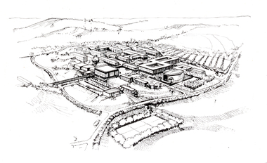
Photograph - Black and White, Aerial Depiction of a Plan for the Mount Helen Campus, c1969, c1969
The new campus at Mount Helen was part of the Ballarat School of Mines, and was known as Ballarat Institute of Advanced Education. The drawing was prepared in the early stages of the Mount Helen campus development, while Stage I buildings ('E', 'F', 'G') were constructed. the Union Building (now Albert Coates Centre), Library, 'S' Building and student accommodation were in the design stage. The original drawing was photographed by using special equipment in the offices of Department of Crown Lands, treasury Place, Melbourne.Artwork showing an aerial view of a planned academic campus at Mount Helen. .1) Black and white print of a line drawing. 2) Transparency of above imagefederation university, federation university australia, feduni, university of ballarat, ballarat institute of advanced education, harrison, vernon, campus, mount helen -
 Federation University Historical Collection
Book - Booklet, University of Ballarat Reconciliation Action Plan, 2009-2010, 2009
Soft covered booklet documenting the University of Ballarat Reconciliation Action Plan. Photographs include Christine Ward, Ben Atkinson, Katrina Beer, Shirley Morganreconciliation action plan, aborigines, aboriginal education unit, ben atkinson, katrina beer, shirley morgan, christine ward, reconciliation, university of ballarat, aboriginal education centre -
Whitehorse Historical Society Inc.
Map, A Plan of part of the Parish of Nunawading, 1984
Hand drawn plan showing the owners or occupiers of land c1860'.Hand drawn plan showing the owners or occupiers of land c1860'. Includes proposed townships of New Brunswick and Norwich. Scate 1 inch : 10 chains.Hand drawn plan showing the owners or occupiers of land c1860'. maps, shire of nunawading -
Whitehorse Historical Society Inc.
Document, A Plan for Mitcham, 1960s
Mitcham chamber of Commerce pamphlet plans for developing Mitcham Shopping Centre to provide off-road parking. Aerial view illustration of shopping centre on cover.Mitcham chamber of Commerce pamphlet plans for developing Mitcham Shopping Centre to provide off-road parking. Aerial view illustration of shopping centre on cover.Mitcham chamber of Commerce pamphlet plans for developing Mitcham Shopping Centre to provide off-road parking. Aerial view illustration of shopping centre on cover.parking, mitcham shopping centre, armstrong, raleigh edward, colombo street, mitcham, elizabeth street, mitcham, mitcham road, mitcham, whitehorse road, mitcham, mitcham chamber of commerce -
 Whitehorse Historical Society Inc.
Document - Report, Blackburn Lake Sanctuary - Environmental Assessment and Master Plan, 1/11/1976
Blackburn Lake Sanctuary : an environmental assessment and master plan - climate, by Winty Calder and Jeremy Pike. Centre for Environmental Studies, University of Melbourne, November 1976.blackburn lake sanctuary, calder, winty, pike, jeremy, climate -
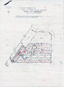
 Ringwood and District Historical Society
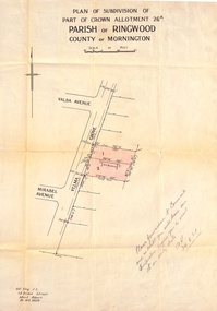
Document, Plan of Subdivision - Part of Crown Allotment 26A, Parish of Ringwood, County of Mornington - Circa 1961
Map showing layout of 2 allotments coloured red in Velma Grove, adjacent to Valda Avenue and Mirabel Avenue, Ringwood East, Vic.Handwritten notation dated 29/8/1961 by Alf King, Licensed Surveyor, 14 Grace Street, Mont Albert (Phone) WX2020 regarding plans being forwarded to Council for inspection visit. -
 Robin Boyd Foundation
Document - Manuscript, Robin Boyd, That Sneaky Strategic Plan, 1971
Boyd discusses the role of Sydney and its Strategic Plan. He touches on floor space ratio but focuses on the goal of enticing residents to return to the inner city as the real challenge of the plan.Original manuscript of the article ‘Sydney’s Sneaky Strategic Plan’, published in The Sunday Australian, 15.8.1971.Typewritten (c copy), quarto, 11 pagesThe last page is a redraft of the third last page.sydney, strategic plan for sydney, urbanisation, decentralisation, city, suburbs, master plan, harry seidler, floor space ratio, inner city residential, robin boyd, manuscript -
Federation University Historical Collection
Plan, Ballarat Common, c 1890
Hand drawn ink plan or field notes for a survey on faintly ruled foolscap paper. Field notes or survey depicting Ballarat Commons, Ballarat Botanical Gardens, Police Paddock and Ballarat Cattle Yards Railways area. 'R.W.' at bottom, Verso 'Ballarat' with various calculations. -
 Federation University Historical Collection
Plan, Ballaarat City Parish Plans, 1931, 09/03/1931
Large Scale plans showing streets, allotments, dimensions, crown grantees, dates granted, etc Sheet 2: Sturt Street, Rubicon Street, Pryor Street, Humffray Street, Sebastopol Street, Armstrong Street South, Fraser Street, Hickman Street ballarat, ballaarat, plans, city of ballarat -
Creswick Campus Historical Collection - University of Melbourne
Document, Nepal - Master Plan for the Forestry Sector Nepal, 1988
A set of master plan documentsDocuments -
 Melbourne Tram Museum
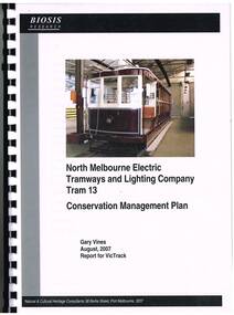
Document - Report, Gary Vines, Biosis Research, "North Melbourne Electric Tramways and Lighting Company Tram 13 Conservation Management Plan", Aug. 2007
Report or plan - 91 A4 pages, clear plastic cover, black card back cover, bound with a black comb binder, titled "North Melbourne Electric Tramways and Lighting Company Tram 13 Conservation Management Plan", providing a detail Conservation Plan for the tramcar. Includes project background, documentary evidence, details of the NMETL, tramcars, similar trams, its history, physical evidence, statement of significance, Conservation policy and implementation, and conclusions. Includes appendices, references and a glossary. Prepared by Gary Vines, Biosis Research, August 2007 for VicTrack. Includes a loose single sheet giving details of the colour scheme.trams, tramways, victrack, conservation planning, nmetl, colour schemes, tram 13 -
 Federation University Historical Collection
Book, Camp Street Precinct Ballarat Conservation Management Plan (Draft), 1999, 10/1999
The conservation management plan was commissioned by the City of Ballarat to assist in the process of planning for the future management and development of the Camp Street precinct, having particular regard for the Camp Street Arts and Education Precinct.White, soft covered, spiral bound book relating to Ballarat's Camp Street Precinct. Contents include: Methodology, buildings and site layout. ballarat, camp street, clare gervasoni, ballarat fine art gallery, art gallery of ballarat, old colonists' hall, former ballarat mining exchange, former state offices, former police court, former police station, former police barracks, old police station, arts academy, archaeology, conservation management plan -
 Flagstaff Hill Maritime Museum and Village
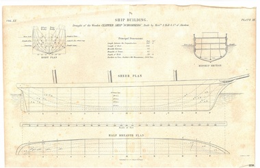
Drawing - Vessel Line Drawing, Ship Building Clipper Ship Schomberg, 1855-1876
This draft plan, a line etching, is of the wooden clipper ship "Schomberg" . It can be assumed from the heading "Ship Building." and the phrase "Built by Messrs. A Hall & Co. of Aberdeen" that the drawing is an example of plans for building a ship, and that the Schomberg ship has chosen to demonstrate this. The plan may have possibly been in a book, as it is made from two well-joined pieces of paper. The original plans would have been drawn up, discussed, reviewed and drawn in more detail before the building of the ship in Aberdeen, Scotland, in 1855. Information on the draft Is as follows: “Principal dimensions: Length between the perpendiculars: 262 feet 6 inches Length of keel 245 feet Breadth extreme: 45 feet Breadth of frame: 42 feet Depth of hold: 29 feet 9 inches Burthen in tons, Builders Old Measurement: 2600 Tons” The publisher firm A & C Black, was founded by Adam and Charles Black in Edinburgh in 1807. Over the years the company has published editions of Encyclopedia Britannica and Whose Who, and reference books, guides and technical books. The printer G Aikman (1788-1865) or his son G Aikman (1830-1905), were both named George. George senior was an early-19th century Scottish printer and publisher. After his death his son became the sole proprietor of the firm until he sold it in 1876. The draft plan uses the vessel Schomberg as its example ship building plan for demonstration purposes. It is significant for its association with the Victorian Heritage Registered shipwreck, the Schomberg. It is an example of a shipo building plan. The Schomberg collection is primarily significant because of the relationship between the objects, as together they have a high potential to interpret the story of the Schomberg. The Schomberg collection is archaeologically significant as the remains of an international passenger ship. The shipwreck collection is historically significant for representing aspects of Victoria’s shipping history and its potential to interpret sub-theme 1.5 of Victoria’s Framework of Historical Themes (living with natural processes). The collection is also historically significant for its association with the shipwreck and the ship, which was designed to be fastest and most luxurious of its day. The Schomberg collection meets the following criteria for assessment: Criterion A: Importance to the course, or pattern, of Victoria’s cultural history. Criterion B: Possession of uncommon, rare or endangered aspects of Victoria’s cultural history. Criterion C: Potential to yield information that will contribute to an understanding of Victoria’s cultural history.Plan; line engraving; draft of the wooden clipper ship 'Schomberg', built in 1855. The drawing on cream paper is made from two well- joined pages. The drawing gives the principal dimensions and labels for the Body Plan, Middle Section, Sheer Plan and Half Breadth Plan. Inscriptions are on the drawing and its rough cardboard storage folder. Publisher: A & C Black. Edinburgh. Printer: G. Aikman sc. EdinborughOn drawing: "SHIP BUILDING" "Draught of the Wooden CLIPPER SHIP SCHOMBERG", Buiilt by Messrs A Halt & Co. of Aberdeen" "Vol XX" "Plate III" "Principal Dimensions""BODY PLAN" "MIDDLE SECTION" "SHEER PLAN" "HALF BREDTH PLAN" "Published by A & C Black, Edinburgh" "G Aikman sc. Edinr" On storage folder: "Receipt Number 381A: "Line engraving draught of wooden ship "Schomberg" "warrnambool, flagstaff-hill-maritime-museum, shipwreck-coast, schomberg, schomberg plan, vessel schomberg, ship building, g. aikman ship plan draftsman, a.& c. black publisher aberdoon, a. hall & co. maker aberdeen, peterborough, clipper ship, captain forbes, black ball line, ship's plan, ship's drawing, line drawing, vessel plan, draft plan, line engraving, vol xx plate iii, a & c black, ship building example drawing, g aikman, 19th century -
 City of Moorabbin Historical Society (Operating the Box Cottage Museum)
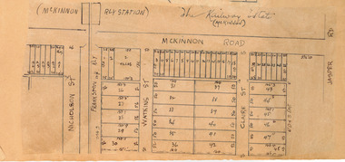
Plan - McKinnon Railway Estate, McKinnon, c 1921
At the end of World War One, there was a renewed interest in residential land and a number of estates opened up in the Municipality of Moorabbin. The train line from the city to Frankston was electrified in 1922 which intensified the sale in the municipality of Moorabbin, particularly land which was in the vicinity of the railway stations.Example of the progress of the Municipality of MoorabbinHand drawn plan of the McKinnon Railway Estate, McKinnonMcKinnon Railway Estate, McKinnon - hand drawn planmckinnon road, watkins street (now bent street), claire street, real estate, mckinnon, moorabbin -
 Kew Historical Society Inc
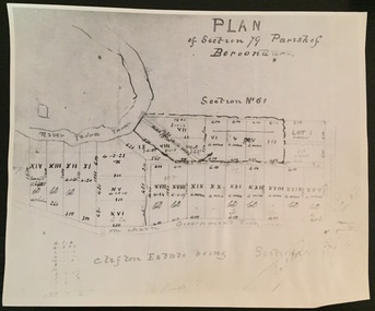
Print - Subdivision Plan (copy), Plan of Section 79 Parish of Boroondara (Clifton Estate), Nineteenth Century
This work forms part of the collection assembled by the historian Dorothy Rogers, that was donated to the Kew Historical Society by her son John Rogers in 2015. The manuscripts, photographs, maps, and documents were sourced by her from both family and local collections or produced as references for her print publications. Many were directly used by Rogers in writing ‘Lovely Old Homes of Kew’ (1961) and 'A History of Kew' (1973), or the numerous articles on local history that she produced for suburban newspapers. Most of the photographs in the collection include detailed annotations in her hand. The Rogers Collection provides a comprehensive insight into the working habits of a historian in the 1960s and 1970s. Together it forms the largest privately-donated collection within the archives of the Kew Historical Society.A photographic reproduction of a plan in the Vale Collection of the State Library of Victoria. The numbered lots represent the first land sales in Kew in the area north of Studley Park Road.maps (kew), plan of section 79 parish of boroondara -
Stawell Historical Society Inc
Map, Western Mining Corporation Limited, Shaft Location Plan April 1981, 1981
Western Mining Corporation Ltd Shaft Location Plan 1981 Very Large Plot Showing Contours and Streets Without names. Sheet 1 0f 2 stawell, mining -
Stawell Historical Society Inc
Map, Western Mining Corporation Ltd Shaft Location Plan 1981, 1981
Western Mining Corporation Ltd Shaft Location Plan 1981 Very Large Plot Showing Contours and Streets Without names. Sheet 2 0f 2 stawell, mining -
 Federation University Historical Collection
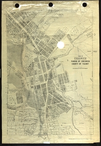
Plan, Creswick, Parish of Creswick, County of Talbot, 1928, 1928
Parish Plan of Creswick showing Slaty Creek, Old Gold Workings, Police Reserve, Railway Station, Public Gardens, Sawpit Gully, Hospital Reserve, Nigh Soil Depot, Eureka Terracotta Tile COmpany, Creswick Creek, Forest COmmission, Roycroft's Racecreswick, eureka terracotta tile co, parish plan -
 Bendigo Military Museum
Plan - PROPOSED BDSC SITE, Bendigo RSL Sub Branch, C.1977
The plan relates to the proposed Bendigo & District Servicemen's Club in Havilah Road. The slightly shaded area is the site. This plan was put to a General Members meeting in September 1976. The club received its Liquor License in 1979. Refer Cat No 8073P for more details. This item was in the collection re David Patterson, refer Cat No 8070.Plan and details on A4 sheet, all text and sketch in black, top has site desired with 2 sets of remarks underneath, at bottom sketch of possible site on Havilah Road Bendigo."Desired site for proposed RSL Licenced Club, Memorial and recreational park"brsl, smirsl, bdsc, plan -
Broadmeadows Historical Society & Museum
Book - Publication, Broadmeadows District Centre Structure Plan, 1988
Written For City of Broadmeadows and Ministry for Planning and EnvironmentHardcover, 104pp. Report in house-bound cover by Merri-bek City Libraries (Formally Moreland City Libraries)non-fictionWritten For City of Broadmeadows and Ministry for Planning and Environmentstructure, planning, broadmeadows, city of broadmeadows, town centre -
 Melbourne Tram Museum
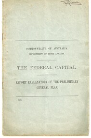
Document - Report, Walter Burley Griffin, Federal Capital Director of Design and Construction, "The Federal Capital - Report Explanatory on the Preliminary General Plan", Oct. 2013
Report - 16 pages + two plans within a grey cover stapled - titled "Commonwealth of Australia Department of Home Affairs - The Federal Capital - Report Explanatory on the Preliminary General Plan" - looking at the site, functions and layout of the proposed capital city of Australia - Canberra. Includes some notes on railways and a rapid transit facility. Signed Walter Burley Griffin, Federal Capital Director of Design and Construction, October 1913.Has in ink in the top right hand corner "Mr. Lormer"trams, tramways, commonwealth government, planning, canberra -
 Kew Historical Society Inc
Plan, J R Mathers & McMillan, 5 Splendid vVlla Allotments,: Segtoune St. & Windsor St., Kew, 1928
Prue Sanderson, in her groundbreaking ‘City of Kew Urban Conservation Study : Volume 2 - Development History’ (1988), summarised the periods of urban development and subdivisions of land in Kew. The periods that she identified included 1845-1880, 1880-1893, 1893-1921, 1921-1933, 1933-1943, and Post-War Development. These periods were selected as they represented periods of rapid growth or decline in urban development. An obvious starting point for Sanderson’s groupings involved population growth and the associated economic cycles. These cycles also highlighted urban expansion onto land that was predominantly rural, although in other cases it represented the decline and breakup of large estates. A number of the plans in the Kew Historical Society’s collection can also be found in other collections, such as those of the State Library of Victoria and the Boroondara Library Service. A number are however unique to the collection.Subdivision plans are historically important documents used as evidence of the growth of suburbs in Australia. They frequently provide information about when the land was sold on which a built structure was subsequently constructed as well as evidence relating to surveyors and real estate and financial agents. The numerous subdivision plans in the Kew Historical Society's collection represent working documents, ranging from the initial sketches made in planning a subdivision to printed plans on which auctioneers or agents listed the prices for which individual lots were sold. In a number of cases, the reverse of a subdivision plan in the collection includes a photograph of a house that was also for sale by the agent. These photographs provide significant heritage information relating house design and decoration, fencing and household gardens.In 1928, five residential allotments bordering Segtoune and Windsor Streets were advertised for sale as part of a subdivision. Four of the blocks faced Segtoune Avenue. The auctioneers proclaimed the advantages of the sites: ‘Situate one minute from the High Street Electric Tram, which now runs direct to Spencer Street via Bridge Road and Flinders Street. Opposite the East Kew Railway Station (Outer Circle Line), which may be reopened In connection with the new Line from Kew to Doncaster; Adjacent lo the Kew Recreation Reserve, Sports Oval, and Swimming Bath; Half Minute from the Shopping Centre of East Kew, Accessible to the State School and Other Educational Centres’. The Harp of Erin Hotel and the route of the Outer Circle Railway line are marked on the plan. The Recreation Reserve and Sport Oval refer to Victoria Park. The Swimming Baths were located on the site of the current Kew Recreation Centre.subdivision plans - kew, segtoune street -- kew (vic.), windsor street -- kew (vic.) -
 Ringwood and District Historical Society
Map, Plan of Subdivision Parish of Ringwood, Victoria - c.1960
Black and white photocopied plan - Part of Crown Allotments 14A and 40A showing blocks in Sharps Court and Salsibury Court, Heathmont. Some blocks showing sale price.K.J. Noonan & Co. Licensed Land Surveyors, Suite 16 "Gloucester Lodge", 445 StKilda Road, Melbourne S.C.2, Telephone BM 1631. References to coloured easements etc., not evident from b&w photocopy. -
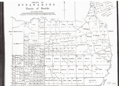 Whitehorse Historical Society Inc.
Document, Plan of Parish of Nunawading, 01/05/1864
Copy of plan of Parish of NunawadingCopy of plan of Parish of Nunawading, County of Bourke, lithographed at the Office of Lands and Survey, Melbourne, 13th May, 1864 showing boundaries of Koonung, Mullum Mullum and Dandenong Creeks.Copy of plan of Parish of Nunawadingland subdivision, parish of nunawading, county of bourke, elgars special survey, koonung creek, mullum mullum creek, dandenong creek -
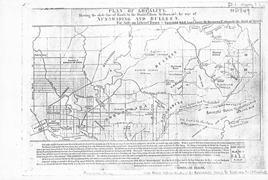 Whitehorse Historical Society Inc.
Map, Plan of locality, 1855-60?
'Plan of locality, showing the whole line of route to the district from Melbourne by way of Nunawading and Bulleen. 2,000 acres for sale... Thomas Ham, Land Agent [ 1855 - 60?]nunawading, bulleen, barkers track, land sales -
Lakes Entrance Historical Society
Book, Department of Conservation and Natural Resources, Draft Management Plan Fisheries
Draft management plan for sustaining the fisheries and fish resources of the Gippsland Lakes, considering both recreational and commercial activities and ecological impact on all other biological species of the lakes.fishing industry, waterways -
Creswick Campus Historical Collection - University of Melbourne
Book, Working Plan for the Victorian School of Forestry Hardwood Forest, 1952
This is a typed working plan for the VSF hardwood forestDocument -
Lakes Entrance Historical Society
Book, Gippsland Lakes Use Strategy Plan Background Report, 1978
Background report from Planning Board 1978Paperback with 125 pagestownships, planning committee -
Federation University Historical Collection
Booklet, Ballarat School of Mines Botanical Gardens Conservation/Restoration Management Plan
A Conservation/Restoration Management Plan for the Ballarat School of Mines Botanical Gardens. The report includes a planting timeline of the plants included in the gardens from 1850. Historical plans and maps are detailed from 1857 up to the site assessment in 2008.Printed report stapled at top left corner.Lisa Palmer written at top right corner in pencil.smb, school of mines ballarat, ballarat school of mines, botanical gardens, smb botanical gardens, conservation, restoration, ballarat school of mines garden, von mueller garden, ferdinand von mueller, botany, living collections, horticulture, gardens