Showing 113059 items
matching road
-
 Glen Eira Historical Society
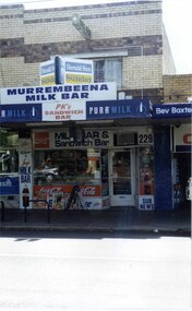
Photograph, Murrumbeena Road, 229, Murrumbeena, 2001
Originally labelled "Beauville Estate, Established 1936, Still Thriving 65 years on, 10th March 2001", the Beauville Estate Album contains colour photographs of houses in the Estate. They were taken around the time of the Beauville Estate’s 65th Heritage Celebration held on 10/03/2001 and donated to the Caulfield Historical Society shortly afterwards. Photographer unknown. From Glen Eira’s Heritage Management Plan by Andrew Ward (1996) Vol 2 p78: In Murrumbeena Road, the shops which form part of the estate are a simple cream brick row relieved by manganese bricks in bands across the upper storeys. City of Glen Eira’s Heritage Management Plan Vol 2 p79 (this is p84 of the pdf version) – HO12 Beauville Estate and environs, Murrumbeena: The Beauville Historic Area is important at the State level as the first large housing estate undertaken by the AV Jennings Construction Co, later Jennings Group Limited, Victoria’s largest home builder. It is important also as a very early estate development incorporating a range of features other than houses and including made roads, shops and recreation facilities. In this respect it was the forerunner of the comprehensively planned housing estate of the post war era. The estate is distinguished by its aesthetic values, as is the earlier and comparable Hillcrest Estate, which are formed by a combination of restrained diversity in house styles, with the exception of no. 30 in the emerging International style, and by a landscaped garden environment. Colour photograph of a section of a double storey, unpainted brick, commercial property containing shops at ground level all with awnings over the footpath. This specific property is a milk bar on street level with plate glass windows and door, colourful advertising and "229' in the top right section of the window. Shop signage says "MURREMBEENA MILK BAR". The upper storey brick residence features a large window, a flat roof and decorative two tone banded brickwork. MURREMBEENA (sic) MILK BAR / PK's / SANDWICH / BAR / MILK BAR & Sandwich Bar / 229 / SUB NEWSmurrumbeena, architectural styles, 1930's, inter war style, a.v. jennings, av jennings, jennings, beauville estate, murrumbeena road, milk bars, commercial establishments, flats, sir albert victor jennings, a v jennings construction co, beauville estate heritage area, glen eira city council, architectural features, jennings group limited, land subdivision, beauville historic area, shops, brick features, window displays, advertising signs, murrembeena (sic) milk bar -
 Glen Eira Historical Society
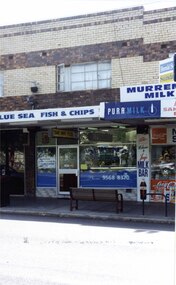
Photograph, Murrumbeena Road, 229A, Murrumbeena, 2001
Originally labelled "Beauville Estate, Established 1936, Still Thriving 65 years on, 10th March 2001", the Beauville Estate Album contains colour photographs of houses in the Estate. They were taken around the time of the Beauville Estate’s 65th Heritage Celebration held on 10/03/2001 and donated to the Caulfield Historical Society shortly afterwards. Photographer unknown. From Glen Eira’s Heritage Management Plan by Andrew Ward (1996) Vol 2 p78: In Murrumbeena Road, the shops which form part of the estate are a simple cream brick row relieved by manganese bricks in bands across the upper storeys.City of Glen Eira’s Heritage Management Plan Vol 2 p79 (this is p84 of the pdf version) – HO12 Beauville Estate and environs, Murrumbeena: The Beauville Historic Area is important at the State level as the first large housing estate undertaken by the AV Jennings Construction Co, later Jennings Group Limited, Victoria’s largest home builder. It is important also as a very early estate development incorporating a range of features other than houses and including made roads, shops and recreation facilities. In this respect it was the forerunner of the comprehensively planned housing estate of the post war era. The estate is distinguished by its aesthetic values, as is the earlier and comparable Hillcrest Estate, which are formed by a combination of restrained diversity in house styles, with the exception of no. 30 in the emerging International style, and by a landscaped garden environment. Colour photograph of a section of a double storey, unpainted brick, commercial property containing shops at ground level all with awnings over the footpath. This specific property is a fish and chip shop. The upper storey brick residence features a curtained window, a flat roof and decorative two tone bands of brickwork. It has a large street seat on the footpath out front.BLUE SEA FISH & CHIPS / TAKE AWAY FOODmurrumbeena, architectural styles, 1930's, inter war style, a.v. jennings, av jennings, jennings, beauville estate, murrumbeena road, milk bars, commercial establishments, flats, fish & chip shops, sir albert victor jennings, a v jennings construction co, beauville estate heritage area, glen eira city council, architectural features, jennings group limited, land subdivision, beauville historic area, brick features, restaurants -
 Surrey Hills Historical Society Collection
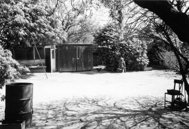
Digital photo, George L Coop, Back yard of 686 Whitehorse Road, Mont Albert c 1953, c1953
This is a photo of the backyard of the property adjacent to the Coop's home. At the time the neighbours were Mrs Daisy McKernan (a widow) and her son Alexander Colin McKernan. The clothes line prop was a forerunner of the clothes hoist. Clothes line props were standard purchase items at many local hardware stores and the donor poetically described them as holding "long lines of drying washing above the dusty democracy of many a rough back yard." Whilst the Coop home is still extant in 2019 and used as professional rooms for Dr Peter Chau, an eye surgeon, 686 Whitehorse Road has been replaced by units. This captures the utilitarian nature of the 'typical' back yard before the advent of rampant consumerism. Large areas of open lawn were a desirable central feature, often edged with neatly contained garden beds. Better lawnmowers, plus the promotion of new chemicals and fertilisers to help home gardeners grow the perfect lawn. Missing is the rotary hoist and the vegetable garden.A black & white photo on a sunny day of a backyard with the following features: a timber shed, an additional shed / hen house, a hand lawn mower leaning against a tree, several hens and a metal drum (perhaps used as bonfire container). A sloping pole/prop may be seen on the left. backyards, (mrs) daisy mckernan, alexander colin mckernan -
 Mt Dandenong & District Historical Society Inc.
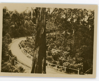
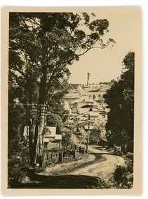
Photograph, Sassafras-Olinda Road, c1913
This set of 8 photographs was produced by the Rose Stenograph Co. c1913 to be included in photograph albums. The show tourist scenes of Sassafras and surrounds. The photographs were donated by a family in Western Australia whose parents lived in Sassafras c1918.Small b & w photograph from a series of 8 showing scenes from Sassafras produced by the Rose Stenograph Co. c1913.On reverse - Sassafras - Olinda Roadsassafras, olinda, sassafras-olinda road -
 Mt Dandenong & District Historical Society Inc.
Photograph, The Main Road, Sassafras, c1913
This set of 8 photographs was produced by the Rose Stenograph Co. c1913 to be included in photograph albums. The show tourist scenes of Sassafras and surrounds. The photographs were donated by a family in Western Australia whose parents lived in Sassafras c1918.Small b & w photograph from a series of 8 showing scenes from Sassafras produced by the Rose Stenograph Co. c1913.On reverse - The Main Road, Sassafras.sassafras -
 Ringwood and District Historical Society
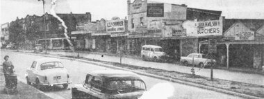
Photograph, Maroondah Highway Central, Ringwood. Main Street shops looking west from Warrandyte Road, c1950's
Newspaper clipping of black and white photograph.Image shows shops on north side of Whitehorse Road between Warrandyte Road and Adelaide Street. -
 Eltham District Historical Society Inc
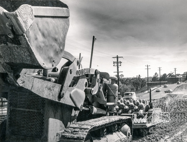
Photograph, Hugh Fisher, Construction of dual road, Main Road, Eltham
Black and white photograph of road construction equipment used in the widening and lane duplication of Main Road, Eltham looking north from near York Street, the old Shire of Eltham offices visible in the distance on leftA1234eltham, main road, construction -
 Ringwood and District Historical Society
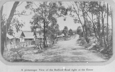
Photograph, Three images of Dublin Road Station Estate, Ringwood promotional photograph, one captioned "A picturesque View of the Bedford Road right at the Estate". 1923
Typed below one photograph, "Bedford Rd. looking towards Ringwood from Dublin Rd., 1923". Another copy is dated 1924. Typed on back of small photographs, "Dublin Rd. estate, corner Bedford Road. 77 lots no deposit and one pound per month." Printed below the small photograph, "A picturesque View of the Bedford Road right at the Estate."Printed on photograph, "Dublin Road Station Estate." Typed below enlargement, "Bedford Road looking uphill from near corner of Illoura Ave. 1923. Homes still there." Written on backing paper, "Soldiers Homes, Bedford Road". Typed on 3rd photo: "Bedford Road in Ringwood's Early Day. On reverse: "About 1924 - Area vicinity Wilana & Greenwood Ave". Reproduced on or from Dublin Road Station Estate Sales Poster 23 November 1923 (Formerly the Blood's Orchard) -
 Whitehorse Historical Society Inc.
Photograph, Canterbury Road, C.1967
Black and white photo of Service Road on south side of Canterbury Road.canterbury road vermont, service roads -
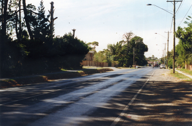
 Whitehorse Historical Society Inc.
Photograph, Whitehorse Road, Blackburn, 2012
Coloured photograph of Whitehorse Road Blackburn looking west, Surrey Road enters Whitehorse Road near the red building on the right - 2012whitehorse road, blackburn, roads, transport -
 Whitehorse Historical Society Inc.
Article, Mitcham Road and Rooks Road rail crossings removal Project, 2012
VicRoads information sheet on the Rail Crossings Removal project at Mitcham and Rooks Roads.VicRoads information sheet on the Rail Crossings Removal project at Mitcham and Rooks Roads.VicRoads information sheet on the Rail Crossings Removal project at Mitcham and Rooks Roads.mitcham road mitcham, rooks road mitcham, railway crossings, vicroads -
 Marysville & District Historical Society
Photograph (Item) - Black and white photograph, c1940s
A black and white photograph of the Marysville-Buxton Road in Marysville in Victoria.A black and white photograph of the Marysville-Buxton Road in Marysville in Victoria. This road leads into Murchison Street, which is the main street, in Marysville in Victoria.Buxton road Crossways in back/ groundmarysville-buxton road, marysville, victoria, murchison street -
 Marysville & District Historical Society
Photograph (Item) - Colour photograph, Unknown
A colour photograph taken of the corner of Pack Road and Falls Road in Marysville in Victoria.A colour photograph taken of the corner of Pack Road and Falls Road in Marysville in Victoria.pack road, falls road, marysville, victoria, photograph -
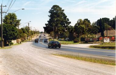
 Whitehorse Historical Society Inc.
Photograph, Mitcham Road Prior to Widening, 1/02/2000 12:00:00 AM
Coloured photograph of Mitcham Road looking towards Park Road, Donvale. Taken from Freeway Reservation prior to construction to widen Mitcham Road.mitcham road, donvale, park road -
 Whitehorse Historical Society Inc.
Photograph, Prior to Widening of Mitcham Road, 1/02/2000 12:00:00 AM
Coloured photograph of Mitcham Road looking towards Springvale Road Junction. Donvale Nursery on right. Taken prior to construction to widen Mitcham Road.mitcham road, donvale, springvale road -
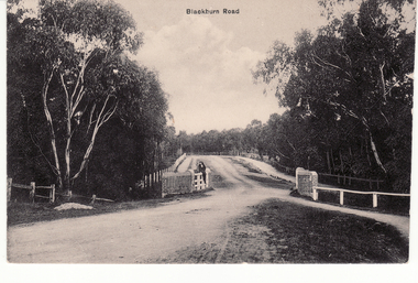 Whitehorse Historical Society Inc.
Postcard - Black and white postcard, Blackburn Road Bridge in Blackburn. Circa 1908, C.1914
Black and white postcard of Blackburn Road at Gardiner's Creek bridge looking south featuring Bridge over unmade road. Entitled 'Blackburn Road'hooke, janet emily, albert arthur, blackburn road, blackburn -
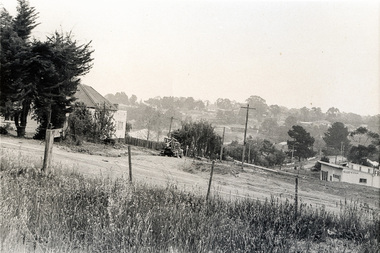
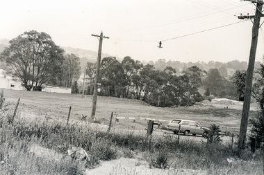
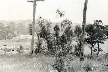
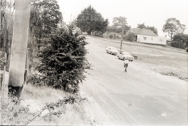
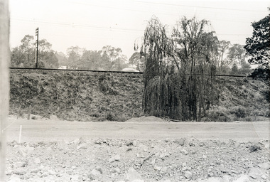
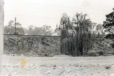
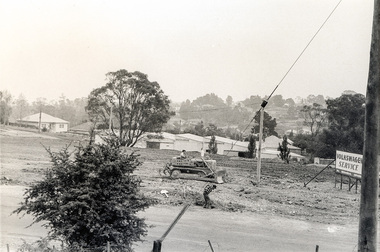
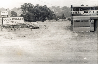
 Eltham District Historical Society Inc
Photograph, Sherbourne Road, Para Road and Simms Road at Briar Hill/Montmorency prior to the upgrade of Sherbourne Road Railway bridge, c.1970
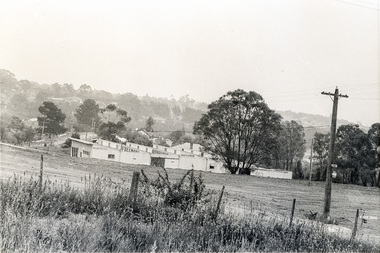
Collection of photographs probably taken around the same time depicting Sherbourne Road, Para Road and Simms Road at Briar Hill/Montmorency prior to the upgrade of Sherbourne Road Railway bridge, c.1970. Photo 01648_ 19 This home owned by Mrs Cameron. Her daughter married a Mr Davey, for whom Davey Road was named - email from M. Jones 20/07/2015 Photographer unknownThese photos are very significant in the documentation of the development of the Briar Hill and Montmorency areas and the changes in the physical landscape along the railway line area.20 black and white prints 9 cm x 13 cm.1970, briar hill, davey road, montmorency, para road, cameron, davey, sherbourne road, simms road, railway line, roadworks -
 Eltham District Historical Society Inc
Photograph, Sherbourne Road, Para Road and Simms Road at Briar Hill/Montmorency prior to the upgrade of Sherbourne Road Railway bridge, c.1970
Collection of photographs probably taken around the same time depicting Sherbourne Road, Para Road and Simms Road at Briar Hill/Montmorency prior to the upgrade of Sherbourne Road Railway bridge, c.1970. Photo 01648_ 19 This home owned by Mrs Cameron. Her daughter married a Mr Davey, for whom Davey Road was named - email from M. Jones 20/07/2015 Photographer unknownThese photos are very significant in the documentation of the development of the Briar Hill and Montmorency areas and the changes in the physical landscape along the railway line area.20 black and white prints 9 cm x 13 cm.1970, briar hill, davey road, montmorency, para road, cameron, davey, sherbourne road, simms road, railway line, roadworks -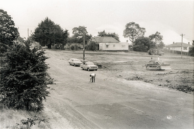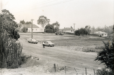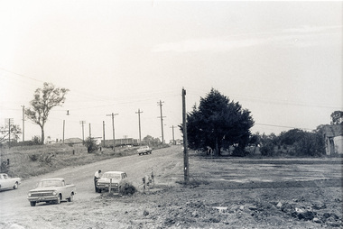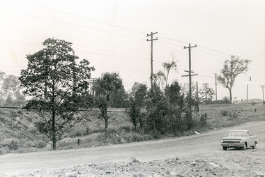
 Eltham District Historical Society Inc
Photograph, Sherbourne Road, Para Road and Simms Road at Briar Hill/Montmorency prior to the upgrade of Sherbourne Road Railway bridge, c.1970
Collection of photographs probably taken around the same time depicting Sherbourne Road, Para Road and Simms Road at Briar Hill/Montmorency prior to the upgrade of Sherbourne Road Railway bridge, c.1970. Photo 01648_ 19 This home owned by Mrs Cameron. Her daughter married a Mr Davey, for whom Davey Road was named - email from M. Jones 20/07/2015 Photographer unknownThese photos are very significant in the documentation of the development of the Briar Hill and Montmorency areas and the changes in the physical landscape along the railway line area.20 black and white prints 9 cm x 13 cm.1970, briar hill, davey road, montmorency, para road, cameron, davey, sherbourne road, simms road, railway line, roadworks