Showing 848 items
matching surveyors
-
 Federation University Historical Collection
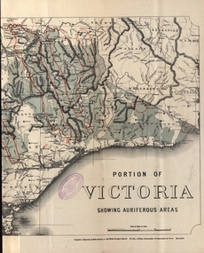
Map - Map and Information, Department of Mines: Map and Suggestions to Prospectors, 1891
The map outlines the auriferous (gold bearing) areas in Victoria. The information for prospectors was prepared by the Department of Mines in 1894Document: 4 page type written Map: Portion of Victoria divided into Counties of 1891. Auriferous areas with red.Reference section on mapgold, auriferous areas, department of mines, victoria, map of victoria, prospectors, commissioner of crown lands, hon a mclean, alexander black, surveyor general, a mclean -
 Ringwood and District Historical Society
Document - Copy of Lands Department Field Notes - Ringwood, Victoria, Field Notes 86.87/108 - Survey O.P. R72A dated August 1886 by Surveyor, L. Thorn
Foolscap size photocopies of survey maps with handwritten notations. -
 Bendigo Historical Society Inc.
Document - OUR STREETS - ORIGIN OF NAMES
Five pages of hand written notes on the origins of our Bendigo streets and the six squares - Golden, Palmerston, Wattle, Market, Brassey and Andrew. The notes give the origin of the names. Notes written by Wes Harry.document, our streets - origin of names, surveyor urquhart, miss margaret brennan, samuel pepys, commissioner mccrae, edwin hargraves, commissioner dowling, commissioner bernal, advertiser, richard larritt, sergeant drought, senior constable stout, golden square, palmeston square, wattle square, market square, brassey square, andrew square, charles dickens, lord palmerston, viscount brassey, cosmopolitan mine, david andrew, sun ack goons, hong yick, wes harry -
 Bendigo Historical Society Inc.
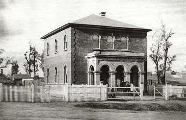
Photograph - GOVERNMENT SURVEYOR'S OFFICE: VIEW STREET, BENDIGO, late 1850's
black and white photo ( copy ): Brick two storey building, with three arched portico at front. Picket fence on side front of building, with railed fence at front. Road is unmade. Tree to RH side of building, small brick building visible to LH side read of building.organization, government, surveyor's office -
 Port Melbourne Historical & Preservation Society
Photograph - Double-sided aerial photograph, Hobson's Bay and the Yarra River/Port Phillip and Western Port Bay, Surveyor General and Director of Mapping, Apr 1990
Landsat imagery - an extract from the atlas of VictoriaAerial photos of Port Phillip and Western Port (double sided aerial photographs). 1995 side A: Hobson's Bay and Yarra River - aerial photo mosaic; side B. Port Phillip and Western Port Bays - satellite photo.port of melbourne authority -
Port Melbourne Historical & Preservation Society
Photograph - Double-sided aerial photograph, Hobson's Bay and the Yarra River/Port Phillip and Western Port Bay, Surveyor General and Director of Mapping, Apr 1990
Landsat imagery - an extract from the atlas of VictoriaAerial photos of Port Phillip and Western Port (double sided aerial photographs), framed and with timber display stand. 1995 side A: Hobson's Bay and Yarra River - aerial photo mosaic; side B. Port Phillip and Western Port Bays - satellite photomelbourne harbor trust - port of melbourne authority -
Port Melbourne Historical & Preservation Society
Map - Survey Map, Captain R Pasley R E, 24 Sep 1855
Survey map to accompany Colonial Engineers Report, September 1855melbourne -
Port Melbourne Historical & Preservation Society
Plan - Toll bar, house and closet, Sandridge, Charles Clay?, Borough Surveyor, 1860s - 1870s
Plan and elevation for Borough of Sandridge toll bar, house and closet, hand drawn and coloured 1860s-70s. Master copy.Signed by Chas. Clay, Suveyor and John L. Forrester (?) and witnessed bt Thomas R. Warren (?).built environment - civic, charles clay, thomas peek warren, john l forrester -
Port Melbourne Historical & Preservation Society
Plan - Fencing and gate, Borough of Port Melbourne, Arthur Victor Heath, Town Surveyor, 27 Jul 1888
Borough of Port Melbourne, 1888 design of fencing and wicket gate for block 52 (bounded by Liardet, Esplanade East and Pickles Streets, and, originally, arm of the Sandridge Lagoon).Signed by John Inglis, James McFarlane, Marcus Erling and witnessed by E.C. Crockford; embossed with seal of Borough (PM):Pencilled "A" top right:John Inglis began a signature bottom left then changed his mind ("Jo")engineering - fences, engineering department - borough of port melbourne, arthur victor heath, marcus earling, edward c crockford, town clerks, john inglis, james mcfarlane -
Port Melbourne Historical & Preservation Society
Plan - Drainage works, cnr Crockford and Raglan Streets, Sandridge, George Kelly, Borough Surveyor, 3 Jun 1864
Sectional plan for drainage work after flood 1864. Corner Crockford Street and Raglan Street.Borough of Sandridgeengineering department - borough of sandridge, engineering - canals and drainage, business and traders - hotels, george kelly -
Port Melbourne Historical & Preservation Society
Plan - Drainage works, cnr Crockford and Raglan Streets, Sandridge, George Kelly, Borough Surveyor, 6 Jun 1864
Ground plan for drainage work after flood 1864. Corner Crockford Street and Raglan Street.Borough of Sandridgeengineering department - borough of sandridge, engineering - canals and drainage, business and traders - hotels, george kelly -
Port Melbourne Historical & Preservation Society
Document - Notice, Land auction, Williamstown Road to Plummer Street, Port Melbourne, R Holden Stone, Borough Surveyor Brighton and Port Melbourne, Mar 1887
Large auction notice advertising sale of land Williamstown Road to Plummer Street 19.3.1887, with general (distorted) plan of Port Melborne and a larger plan of the allotmentstown planning, fishermans bend, land sales -
Port Melbourne Historical & Preservation Society
Plan - Township of Sandridge, 1855
COPYRIGHT PUBLIC RECORDS OFFICE Plan of the Township of Sandrdge 1855 - copy from Public Record Office 1978local government - municipal district of sandridge, town planning, j jones -
 Bendigo Historical Society Inc.
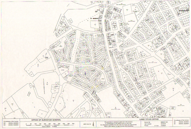
Map - LONG GULLY HISTORY GROUP COLLECTION: LONG GULLY AREA
Copy of a map showing streets and allotments in the Long Gully area, last updated 30/05/97, printed 19/06/97. Made by the Land Titles Office. Some street names, reserves and allotment numbers are printed on the map.bendigo, history, long gully history group, the long gully history group - long gully area, land titles office, office of surveyor general, city of bendigo, shire of marong, state electricity commission -
 Bendigo Historical Society Inc.
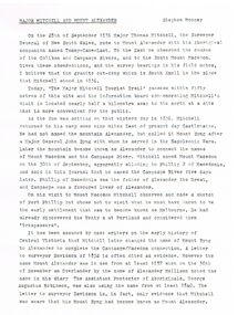
Document - MAJOR MITCHELL AND MOUNT ALEXANDER
Typed notes mentioning the naming of Mount Alexander, Coliban, Campaspe and who named them. Also the origins of the names.document, major mitchell and mount alexander, tommy-came-last, the major mitchell tourist trail, major general john byng, phillip of macedonia, alexander the great, henty s, surveyor davidson, alexander mollison, george augustus robinson, william morton, mr charles hotson ebden, john randell, public library of melbourne, les blake, governor burke, phillip parker king, crown solicitor henry field gurner, arthur phillip, hume, australia felix expedition, l blake, place names of victoria, g brenmer, booklet for secondary schools, m cannon, historical records of victoria vol 1, j h l cumpston, thomas mitchell surveyor general and explorer, h f gurner, chronicle of port phillip, t l mitchell, three expeditions into the interior of eastern australia, a f mollison, an overlanding diary, w l morton, adventures of a pioneer, m s 5188, itinerary from the journal of the exploring expedition returning from portland bay, m s 5189, mitchell's 1837 map, j o randell, pastoral settlement in northern victoria vol 1, pastoral settlement in northern victoria vol 2, records of the victorian archaeological survey number 5, journals of george augustus robinson, t c sargent, some peninsular names in australia felix, w h wells, a geographical dictionary or gazetteer of the australian colonies -
Tatura Irrigation & Wartime Camps Museum
Surveyors Compass, Brush and Drummond Melbourne, 1920s
Owned by donor's father and used surveying for irrigation purposes.Round metal case containing magnetic compass needle, eyepiece and sighting hair. The sighting wire frame secures the neelde in a fixed position when depressed, complete with metal close fit lid and leather carrying pouch and strap.irrigation, surveying -
Stawell Historical Society Inc
Map, Fred W Wright Surveyor, Plan of the Borough of Stawell showing Mining leases & reefs 1870, 1870
Mining details. Including Tramways, Water Races. Crushing Mills. Reefs and Reserves.Copy of Original Showing Stawell Borough with details including mining leases Companies and MillsInsert with details of Sections 23, 34, 35 & 36. Fred W Wright 12 May 1870mining -
Koorie Heritage Trust
Book, Bonwick, James, Port Phillip settlement, 1883
Contents: Discovery; Mr. Grimes round the Bay, 1803; Settlement of 1803; The settlement of 1826; Hume and Hovell's overland journey; The Western Port settlement; Captain Sturt on the Murray; Portland Bay settlement in 1834; Major Mitchell's discoveries in Australia Felix; Life of John Batman; Batman's journal and report; The wild white man; The surveyor's note-book and report; Life of Mr. Fawkner before 1835; Fawkner on the Yarra Yarra; Official correspondence; The Port Phillip Association; Official recognition of trespassers; First Government of Port Phillip; Mr Gellibrand lost in the bush; The Governor's visit to the Yarra; Melbourne and its land sale; The stock question; Mr Mackillop's narrative; Progress of the settlement; The early Melbourne press; Discovery of Gipps Land; The Black Question; Narratives of Old Hands; Causes of emigration in 1835; An Overland journeyx, 537 pages, [36] leaves of plates (some folded.) illustrations (1 colour), facsimiles, portraits ; 23 cm.Contents: Discovery; Mr. Grimes round the Bay, 1803; Settlement of 1803; The settlement of 1826; Hume and Hovell's overland journey; The Western Port settlement; Captain Sturt on the Murray; Portland Bay settlement in 1834; Major Mitchell's discoveries in Australia Felix; Life of John Batman; Batman's journal and report; The wild white man; The surveyor's note-book and report; Life of Mr. Fawkner before 1835; Fawkner on the Yarra Yarra; Official correspondence; The Port Phillip Association; Official recognition of trespassers; First Government of Port Phillip; Mr Gellibrand lost in the bush; The Governor's visit to the Yarra; Melbourne and its land sale; The stock question; Mr Mackillop's narrative; Progress of the settlement; The early Melbourne press; Discovery of Gipps Land; The Black Question; Narratives of Old Hands; Causes of emigration in 1835; An Overland journeymelbourne (vic.) -- history -- to 1834. | melbourne (vic.) -- history -- 1834-1851. | port phillip bay region (vic.) -- history. -
Koorie Heritage Trust
Book, Baker, D.W.A, The civilised surveyor : Thomas Mitchell and the Australian Aborigines, 1997
By the 1830's the squatters were poised to extend theri runs over eastern Australia and so dispossess untold thousands of Aboriginal families of their land. Mitchell witnessed at first hand some of the worst years of a monstrous and incomprehensible disaster. More than that, his work directly assisted in this destruction.xv, 213 pages : illustrations, maps ; 22 cm.By the 1830's the squatters were poised to extend theri runs over eastern Australia and so dispossess untold thousands of Aboriginal families of their land. Mitchell witnessed at first hand some of the worst years of a monstrous and incomprehensible disaster. More than that, his work directly assisted in this destruction.mitchell, thomas, sir, 1792-1855 -- relations with aborigines, australian -- new south wales. | mitchell, thomas, sir, 1792-1855 -- journeys -- new south wales. | aboriginal australians -- new south wales -- first contact with europeans. | aboriginal australians -- first contact with europeans. -
 Bayside Gallery - Bayside City Council Art & Heritage Collection
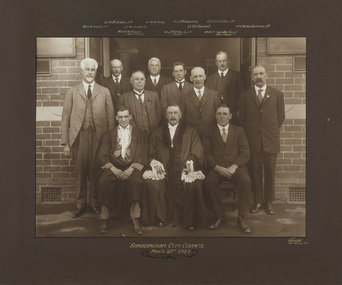
Photograph - gelatin silver photograph, Sarony & Co, The Councillors and Officers of the first City of Sandringham Council, 1923
This photograph records the Councillors and officers on the day that the Town of Sandringham became a City, and the first meeting of the City of Sandringham Council was held. Sandringham was originally part of the Shire of Moorabbin. On 28 February 1917, Sandringham was severed from Moorabbin and incorporated as the Borough of Sandringham. It was proclaimed a Town on 9 April 1919 and a City on 21 March 1923. city of sandringham, councillors, local government, municipality, mayor, cr. h.b. grace, cr. w.h. kay, cr. j.m. ramsay, cr. f.n. gibbs, cr. g.w. knott, cr. r. chisholm, t.g. farrant, cr. c.a. hartsmann, m.h.t. williams, town clerk, cr. j.t.d. beck, m.w.t. sanderland, surveyor -
 Bayside Gallery - Bayside City Council Art & Heritage Collection
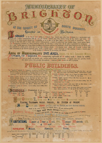
Certificate - Illuminated certificate, Brighton Municipal Certificate, 1861
bayside city council, borough of brighton, illuminated, certificate, population, public buildings, surveyor, council, borough, county of bourke, census, colony of victoria -
 Kew Historical Society Inc
Photograph - 29 Uvadale Grove, Kew, 1920
The numerous subdivision plans in the Kew Historical Society's collection represent working documents, ranging from the initial sketches made in planning a subdivision to printed plans on which auctioneers or agents listed the prices for which individual lots were sold. In a number of cases, the reverse of a subdivision plan in the collection includes a photograph of a house that was also for sale by the agent. Subdivision plans are historically important documents used as evidence of the growth of suburbs in Australia. They frequently provide information about when the land was sold on which a built structure was subsequently constructed as well as evidence relating to surveyors and real estate and financial agents. These photographs provide significant heritage information relating house design and decoration, fencing and household gardens.When 29 Uvadale Grove, Kew was offered for sale it was described as: ‘Kew. Fine locality, 3 minutes Cotham Road. Splendidly built 6 roomed Brick Villa. Rooms 17 x 14, 16 x 13, &c. Beautifully fitted throughout. Land 70 x 134 to ROW.’ The price was advertised as being £1,400. The house exhibits key features of Federation architecture such as the gabled roof with a facing of half-timber and stucco. The veranda has a curved corrugated iron roof supported by timber pillars and fretwork. The slate roof with terra cotta ridging and finials marks a transition to the more common use of Marseilles tiles in Federation architecture.subdivisions - kew (vic.), 29 uvadale grove - kew (vic.) -
 Kew Historical Society Inc
Photograph - 'Mount Eri', 9 Highbury Grove, 1919
Subdivision plans are historically important documents used as evidence of the growth of suburbs in Australia. They frequently provide information about when the land was sold on which a built structure was subsequently constructed as well as evidence relating to surveyors and real estate and financial agents. The numerous subdivision plans in the Kew Historical Society's collection represent working documents, ranging from the initial sketches made in planning a subdivision to printed plans on which auctioneers or agents listed the prices for which individual lots were sold. In a number of cases, the reverse of a subdivision plan in the collection includes a photograph of a house that was also for sale by the agent. These photographs provide significant heritage information relating house design and decoration, fencing and household gardens.A photograph of Mount Eri, 9 Highbury Grove, an 11-room house for sale near the junction of Cotham and Glenferrie Roads. The substantial red brick, slate-roofed house and its location are not identified in the photograph, although the extent of the house is noted. It was described then as ‘well situated’ and close to 3 trams. Mathers, a financial agent in Cotham Road, placed advertisements about the sale of the property in The Argus in May and June 1919. The advertisement additionally refers to a billiard room and asserts that the house has every modern convenience. An annotation on the plan indicates that the house, with tennis court, was sold for £1960. Following extensive research, the house has now been conclusively identified, albeit extended and rendered. The house was originally built in the 19th century as a school and for much of the 20th century was used as a venue for receptions. -
 Kew Historical Society Inc
Photograph - Victorian Villa, High Street, c.1922
Subdivision plans are historically important documents used as evidence of the growth of suburbs in Australia. They frequently provide information about when the land was sold on which a built structure was subsequently constructed as well as evidence relating to surveyors and real estate and financial agents. The numerous subdivision plans in the Kew Historical Society's collection represent working documents, ranging from the initial sketches made in planning a subdivision to printed plans on which auctioneers or agents listed the prices for which individual lots were sold. In a number of cases, the reverse of a subdivision plan in the collection includes a photograph of a house that was also for sale by the agent. These photographs provide significant heritage information relating house design and decoration, fencing and household gardens.An old inscription on this photograph identifies it as ‘an elegant timber villa in High Street. It occupied part of Lot 91, bought by Edward Glyn in the land sale of 16th October 1851, and run as a flower farm’. The subdivision called the ‘Flower Farm Estate’ in East Kew occurred in 1922. [The subdivision plan is on the reverse of this photo.] The Estate included 61 lots on either side of Boorool Road between High Street and Harp Road. In the MMBW Detail Plan 2017 of 1926, a number of these new villas had already been built. Matching houses with MMBW maps can always be a challenge, however if this house was near the corner of Boorool Road and High Street, it seems to fit the profile of a house called ‘Maxton’ (demolished).Photographer's name on photograph, lower right, and stamp on mount lower right: "A. Aberline, Glenferrie".houses - maxton - high street - kew (vic.), violet farm estate, subdivisions - kew (vic.) -
 Kew Historical Society Inc
Photograph - W.B. Villa, Kew, c.1919
The photograph offers significant information relating to late Victorian / Federation colour schemes and fencing.The block fronted villa has a corrugated iron roof and a flat projecting verandah, ornamented with a trellis design of timber. The front window features a timber shade, mounted on brackets. The treatment of the block-fronted panels shows that there is an attempt to highlight imitation quoining through use of a darker colour. The windows and door are also in this darker shade. The front fence and gate are made of wooden pickets. It is unlikely that the photograph was taken at the time of the villa's construction given the size of the shrub/tree in the front garden.Subdivision plans are historically important documents used as evidence of the growth of suburbs in Australia. They frequently provide information about when the land was sold on which a built structure was subsequently constructed as well as evidence relating to surveyors and real estate and financial agents. The numerous subdivision plans in the Kew Historical Society's collection represent working documents, ranging from the initial sketches made in planning a subdivision to printed plans on which auctioneers or agents listed the prices for which individual lots were sold. In a number of cases, the reverse of a subdivision plan in the collection includes a photograph of a house that was also for sale by the agent. These photographs provide significant heritage information relating house design and decoration, fencing and household gardens.A real estate photograph, mounted on brown card, showing a double fronted weatherboard villa, located in Kew, Victoria. On the reverse of the photograph is a subdivision plan for the Altyre Estate.Stamped on mount: Top - "KEW. Close tram. Fine View. / W.B. Villa Containing 8 Rooms. / Up-to-date Conveniences. EL Etc." Below - "Land 40 x 165. 615 pounds. Sold"houses - kew, real estate photographs -
 Kew Historical Society Inc
Photograph - Brick and Stucco Bungalow, J E Barnes, c.1920
The Kew Historical Society's map collection includes a substantial number of real estate subdivision plans, mainly of Kew but also of surrounding suburbs in Melbourne. Most of the subdivision plans date from the 1920s and 1930s when the districts old homes and local farmland were being split up to accommodate residential growth in the postwar period. These early plans were assembled by a local firm, Jas R Mather & McMillan, which had an office in Cotham Road. Many of the plans, and sometimes photos, were annotated by the agents.Subdivision plans are historically important documents used as evidence for the growth of suburbs in Australia. They frequently provide information about when the land was sold as well as evidence relating to surveyors and real estate and financial agents. The numerous subdivision plans in the Kew Historical Society's collection represent working documents, ranging from the initial sketches made in planning a subdivision to printed plans on which auctioneers or agents listed the prices for which individual lots were sold. In a number of cases, the reverse of a subdivision plan in the collection includes a photograph of a house that was also for sale by the agent. These photographs provide significant heritage information relating house design and decoration, fencing and household gardens.The photograph may also be aesthetically significant depending o the importance of the photographic atelier.Real estate photograph for a local agent by the Kew photographer, Josiah Earl Barnes. The photo is of a weatherboard or brick rendered bungalow with a twisted wire fence. Given Barnes' status a a Kew photographer, the house is probably locate din Kew or East Kew. Unfortunately the handwritten information on the mount bordering the photo is damaged and cannot be read. The bungalow has a gabled, tiled roof with terra cotta finials at the front of both gables. The house has a central doorway, framed by a pseudo portico supported by four wooden columns. On each side of the doorway, at the front, there are paired sash windows, which, like the half-timbered gable, are picked out in a darker colour.Handwritten, mostly illegible description by selling agent on mount surround: " .... in Diningroom, Drawing Rooms, ... Photographers details printed on mount: "J. E. Barnes / Photo / Phone 1966 Haw KEW"houses - kew, bungalows - kew, real estate photographs, j.e. barnes -- photographer -
 Kew Historical Society Inc
Photograph - Victorian Double-fronted Brock Villa, Cotham Road, c. 1919
The Kew Historical Society's map collection includes a substantial number of real estate subdivision plans, mainly of Kew but also of surrounding suburbs in Melbourne. Most of the subdivision plans date from the 1920s and 1930s when the districts old homes and local farmland were being split up to accommodate residential growth in the postwar period. These early plans were assembled by a local firm, Jas R Mather & McMillan, which had an office in Cotham Road. Many of the plans, and sometimes photos, were annotated by the agents.Subdivision plans are historically important documents used as evidence for the growth of suburbs in Australia. They frequently provide information about when the land was sold as well as evidence relating to surveyors and real estate and financial agents. The numerous subdivision plans in the Kew Historical Society's collection represent working documents, ranging from the initial sketches made in planning a subdivision to printed plans on which auctioneers or agents listed the prices for which individual lots were sold. In a number of cases, the reverse of a subdivision plan in the collection includes a photograph of a house that was also for sale by the agent. These photographs provide significant heritage information relating house design and decoration, fencing and household gardens.The photograph may also be aesthetically significant depending o the importance of the photographic atelier.Real estate photographs of a classic double-fronted late Victorian brick villa. It central location in Cotham Road, Kew enabled the selling agent to note its proximity to the tram. With seven rooms, all ‘modern conveniences’, and land of 66×167, the house was to be sold for £1100. The villa has a number of interesting features including a pattern within the slate roof as well as the use of polychrome brickwork under the eaves and on the façade. The intricacy of the cast iron lace is emphasised by the line of projecting wooden blocks above it. The picket gate is painted a different colour to the pickets of the fence. The house has a name (illegible) that is attached to the inset cast iron lace of the central projecting gable in the veranda. Stamped on mount: "Kew. Central. Close tram. / Comfortable Brick Villa. / Containing 7 rooms / Modern conveniences: / Land 66 x 167. Sold 1100 pounds:"houses - kew, victorian villas, real estate photographs, cotham road - kew -
 Kew Historical Society Inc
Photograph - Double-fronted Edwardian Villa, c.1918
The Kew Historical Society's map collection includes a substantial number of real estate subdivision plans, mainly of Kew but also of surrounding suburbs in Melbourne. Most of the subdivision plans date from the 1920s and 1930s when the districts old homes and local farmland were being split up to accommodate residential growth in the postwar period. These early plans were assembled by a local firm, Jas R Mather & McMillan, which had an office in Cotham Road. Many of the plans, and sometimes photos, were annotated by the agents.Subdivision plans are historically important documents used as evidence for the growth of suburbs in Australia. They frequently provide information about when the land was sold as well as evidence relating to surveyors and real estate and financial agents. The numerous subdivision plans in the Kew Historical Society's collection represent working documents, ranging from the initial sketches made in planning a subdivision to printed plans on which auctioneers or agents listed the prices for which individual lots were sold. In a number of cases, the reverse of a subdivision plan in the collection includes a photograph of a house that was also for sale by the agent. These photographs provide significant heritage information relating house design and decoration, fencing and household gardens.The photograph may also be aesthetically significant depending on the importance of the photographic atelier.On the reverse of a subdivision plan of the Palmyra Estate (Kew) is a photograph of a double-fronted Edwardian villa. The weatherboard and stucco house with high brick chimneys provides a clear indication of the style of curtains and gardens in houses of the period. Holland blinds with lace inserts are used in the left front window. They are combined with long lace curtains. The garden, with its curved pathway is bordered with garden beds that include marguerite daisies and roses. Reflecting a new interest in the Australian landscape, tree ferns and ground ferns are planted closer to the house.houses - kew, architecture - edwardian, real estate photographs -
 Kew Historical Society Inc
Plan - Subdivision : Cotham and Glenferrie Roads, J R Mathers & McMillan
The Kew Historical Society's map collection includes a substantial number of real estate subdivision plans, mainly of Kew but also of surrounding suburbs in Melbourne. Most of the subdivision plans date from the 1920s and 1930s when the districts old homes and local farmland were being split up to accommodate residential growth in the postwar period. These early plans were assembled by a local firm, Jas R Mather & McMillan, which had an office in Cotham Road. Many of the plans, and sometimes photos, were annotated by the agents.Subdivision plans are historically important documents used as evidence for the growth of suburbs in Australia. They frequently provide information about when the land was sold as well as evidence relating to surveyors and real estate and financial agents. The numerous subdivision plans in the Kew Historical Society's collection represent working documents, ranging from the initial sketches made in planning a subdivision to printed plans on which auctioneers or agents listed the prices for which individual lots were sold. In a number of cases, the reverse of a subdivision plan in the collection includes a photograph of a house that was also for sale by the agent. These photographs provide significant heritage information relating house design and decoration, fencing and household gardens.The photograph may also be aesthetically significant depending on the importance of the photographic atelier.An undated and untitled hand-drawn and coloured subdivision plan detailing the boundaries of a number of irregular allotments bordering Cotham Road, Glenferrie Road and Stirling Avenue (now Stirling Street). The plan predates the actual subdivision that led to the creation of the eight commercial properties occupying 118-132 Cotham Road. The plan may represent an old subdivision that was further subdivided at a later date, or it may be a subdivision that never eventuated. On MMBW Detail Plan 1575 (1903), the area represented by the proposed subdivision was residential rather than commercial. The irregularity of lots is also apparent in the MMBW Plan. The largest of the unnumbered blocks on the hand-drawn subdivision plan may relate to the boundaries of the nineteenth century mansion identified as ‘Kelso’ on the MMBW Plan.subdivision plans - kew, cotham road - kew,, glenferrie road - kew , stirling avenue street - kew -
 Kew Historical Society Inc
Photograph - Cottage, probably East Kew, A. Aberline, 1920s
The Kew Historical Society's map collection includes a substantial number of real estate subdivision plans, mainly of Kew but also of surrounding suburbs in Melbourne. Most of the subdivision plans date from the 1920s and 1930s when the districts old homes and local farmland were being split up to accommodate residential growth in the postwar period. These early plans were assembled by a local firm, Jas R Mather & McMillan, which had an office in Cotham Road. Many of the plans, and sometimes photos, were annotated by the agents.Subdivision plans are historically important documents used as evidence for the growth of suburbs in Australia. They frequently provide information about when the land was sold as well as evidence relating to surveyors and real estate and financial agents. The numerous subdivision plans in the Kew Historical Society's collection represent working documents, ranging from the initial sketches made in planning a subdivision to printed plans on which auctioneers or agents listed the prices for which individual lots were sold. In a number of cases, the reverse of a subdivision plan in the collection includes a photograph of a house that was also for sale by the agent. These photographs provide significant heritage information relating house design and decoration, fencing and household gardens.The photograph may also be aesthetically significant depending on the importance of the photographic atelier.An elevated, modest weatherboard house, photographed towards the end of the construction phase. The lower section of the weatherboards are exposed and stained. The upper section is rendered with rough-cast. The tiled roof has a single gable that extends over the centrally placed front porch. On the porch, the door and single sidelight are filled with coloured leadlight whereas the casement windows in the front rooms contain plain glass. The leadlight and the wrought iron of the verandah are the only decorative elements of the utilitarian design. The location of the house, which was advertised for sale, has not to date been identified. The real estate photograph is mounted on the reverse of a subdivision plan for the Harvest Home Estate, Kew East.Photographer's stamp, lower right on mount: "A. Aberline, Glenferrie"houses - kew, bungalows - kew, real estate photographs