Showing 905 items
matching wagons
-
 Eltham District Historical Society Inc
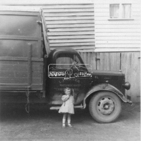
Photograph, Len Parker's Bedford truck at the Tosch home in Panton Hill, c.1952
Len Parker's Bedford truck is featured in one of the public art mosaics in Were Street, Montmorency. Mr Parker by Grace de Visser (EDHS Newsletter No. 249, December 2019) Len Parker was a regular sight around the district for almost 40 years, selling fruit and veggies from the back of his truck to his regular customers between 1939 and 1978, first in a 1927 Chevy then a 1949 Bedford truck. Len’s connection to the Eltham district started long before he was born. His father Fred first came through the district in the early 1900s. With horse and cart buying and selling what was available at the markets using his mothers’ home in North Melbourne as his base. Fred settled and developed a market garden in the rich soil along the creek at Watsons Creek, Christmas Hills in 1903. Ada Watson was almost five years old and one of eight siblings aged two to sixteen, when her Grandfather and Father both named Christopher Watson brought the Eltham Hotel and they moved from Richmond. Ada’s mother was formerly Emily Silk whose parents Martha and John Silk had been farming in Eltham around 1858 and much later a dairy farmer in Fitzroy. In 1917 at St Margaret’s Church Eltham, Fred aged 44 married Ada aged 35 who was still living and working at the Eltham Hotel. Six years later Ada died from cancer leaving Fred with two small children, Rose five and Len three. Len as a young boy, like his father before him worked the land with horses, growing vegetables, mainly potatoes, cabbages, pumpkins, beans, and tomatoes, selling the excess at the market. Len took over from his ageing father Fred, who had established similar rounds selling door to door with a horse and cart. Len preferred mechanical horsepower to the real kind! In 1939 at the age of eighteen Len brought an old 1927 Chevy Truck. He was taught how to drive it and two weeks later got his driver’s Licence. The Chevy truck had an old wagon on the back with no doors, only hessian bags to keep the wind out! Len had paid 75 pounds for it, kept it for ten years and sold it for the same price! Len’s blue 1949 Bedford was brought new in 1950 for 900 pounds with only a tray back on it. Straight away Len had a wooden frame covered with canvas added, with a roll up front and back. In later years, more solid sides replaced the canvas. Benches were added to hold the boxes of fruit and vegetables, with room to move in the middle, a fruit shop on wheels. Len had large scales attached to a box for weighing the fruit and veggies and many a district baby was also weighed on them. Len would stop at customer’s homes, take their orders and with his big cane basket on his arm deliver their order to their door. On his rounds he always wore a big soft back leather apron and a black or navy beret. If it was cold, he wore a ‘bluey’ jacket on his tall slender frame. Len would go to the markets early Thursday morning, only buying what was not grown at home or brought from his brother in law’s orchard. On his way home Len would start his ‘rounds’ in Lower Plenty and then Montmorency and parts of Eltham. Friday’s regulars were in Research, Kangaroo Ground and Panton Hill. Saturdays were Panton Hill and Christmas Hills. When Len retired in 1978, due to changing social times, women were working more and supermarkets starting to take over; his ageing truck was retired too. In 1999 his son Jim had the Bedford restored, Len was very happy to see ‘Beddy’ all shiny and new once again with just a tray back, like when it was new. Jim still drives the ‘Beddy’ to Heritage Truck shows twenty years on. Len married, had five children and lived most of his life, (except during World War 2 when he served in New Guinea), at Watsons Creek, Christmas Hills dying there in 2006 and is buried at the Kangaroo Ground cemetery with his wife of 64 years, Stella nee Tosch 1917 - 2007. Grace de Visser, the author of this article, is the daughter of Len Parker and a descendant of the two former owners of the Eltham Hotel, both named Christopher Watson. bedford truck, len parker, panton hill, tosch property -
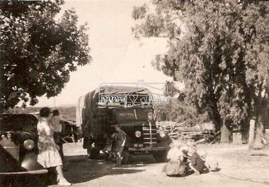
 Eltham District Historical Society Inc
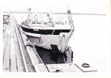
Photograph, Len Parker's Bedford truck, c.1962
Len Parker's Bedford truck is featured in one of the public art mosaics in Were Street, Montmorency. The little girl is Grace de Visser's sister. Mr Parker by Grace de Visser (EDHS Newsletter No. 249, December 2019) Len Parker was a regular sight around the district for almost 40 years, selling fruit and veggies from the back of his truck to his regular customers between 1939 and 1978, first in a 1927 Chevy then a 1949 Bedford truck. Len’s connection to the Eltham district started long before he was born. His father Fred first came through the district in the early 1900s. With horse and cart buying and selling what was available at the markets using his mothers’ home in North Melbourne as his base. Fred settled and developed a market garden in the rich soil along the creek at Watsons Creek, Christmas Hills in 1903. Ada Watson was almost five years old and one of eight siblings aged two to sixteen, when her Grandfather and Father both named Christopher Watson brought the Eltham Hotel and they moved from Richmond. Ada’s mother was formerly Emily Silk whose parents Martha and John Silk had been farming in Eltham around 1858 and much later a dairy farmer in Fitzroy. In 1917 at St Margaret’s Church Eltham, Fred aged 44 married Ada aged 35 who was still living and working at the Eltham Hotel. Six years later Ada died from cancer leaving Fred with two small children, Rose five and Len three. Len as a young boy, like his father before him worked the land with horses, growing vegetables, mainly potatoes, cabbages, pumpkins, beans, and tomatoes, selling the excess at the market. Len took over from his ageing father Fred, who had established similar rounds selling door to door with a horse and cart. Len preferred mechanical horsepower to the real kind! In 1939 at the age of eighteen Len brought an old 1927 Chevy Truck. He was taught how to drive it and two weeks later got his driver’s Licence. The Chevy truck had an old wagon on the back with no doors, only hessian bags to keep the wind out! Len had paid 75 pounds for it, kept it for ten years and sold it for the same price! Len’s blue 1949 Bedford was brought new in 1950 for 900 pounds with only a tray back on it. Straight away Len had a wooden frame covered with canvas added, with a roll up front and back. In later years, more solid sides replaced the canvas. Benches were added to hold the boxes of fruit and vegetables, with room to move in the middle, a fruit shop on wheels. Len had large scales attached to a box for weighing the fruit and veggies and many a district baby was also weighed on them. Len would stop at customer’s homes, take their orders and with his big cane basket on his arm deliver their order to their door. On his rounds he always wore a big soft back leather apron and a black or navy beret. If it was cold, he wore a ‘bluey’ jacket on his tall slender frame. Len would go to the markets early Thursday morning, only buying what was not grown at home or brought from his brother in law’s orchard. On his way home Len would start his ‘rounds’ in Lower Plenty and then Montmorency and parts of Eltham. Friday’s regulars were in Research, Kangaroo Ground and Panton Hill. Saturdays were Panton Hill and Christmas Hills. When Len retired in 1978, due to changing social times, women were working more and supermarkets starting to take over; his ageing truck was retired too. In 1999 his son Jim had the Bedford restored, Len was very happy to see ‘Beddy’ all shiny and new once again with just a tray back, like when it was new. Jim still drives the ‘Beddy’ to Heritage Truck shows twenty years on. Len married, had five children and lived most of his life, (except during World War 2 when he served in New Guinea), at Watsons Creek, Christmas Hills dying there in 2006 and is buried at the Kangaroo Ground cemetery with his wife of 64 years, Stella nee Tosch 1917 - 2007. Grace de Visser, the author of this article, is the daughter of Len Parker and a descendant of the two former owners of the Eltham Hotel, both named Christopher Watson. bedford truck, len parker -
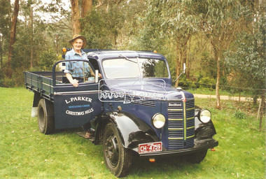 Eltham District Historical Society Inc
Photograph, Len Parker with his restored Bedford truck, 1999
Len's Bedford truk is featured in one of the Montmorency Were Street shopping precinct mosaics. Mr Parker by Grace de Visser (EDHS Newsletter No. 249, December 2019) Len Parker was a regular sight around the district for almost 40 years, selling fruit and veggies from the back of his truck to his regular customers between 1939 and 1978, first in a 1927 Chevy then a 1949 Bedford truck. Len’s connection to the Eltham district started long before he was born. His father Fred first came through the district in the early 1900s. With horse and cart buying and selling what was available at the markets using his mothers’ home in North Melbourne as his base. Fred settled and developed a market garden in the rich soil along the creek at Watsons Creek, Christmas Hills in 1903. Ada Watson was almost five years old and one of eight siblings aged two to sixteen, when her Grandfather and Father both named Christopher Watson brought the Eltham Hotel and they moved from Richmond. Ada’s mother was formerly Emily Silk whose parents Martha and John Silk had been farming in Eltham around 1858 and much later a dairy farmer in Fitzroy. In 1917 at St Margaret’s Church Eltham, Fred aged 44 married Ada aged 35 who was still living and working at the Eltham Hotel. Six years later Ada died from cancer leaving Fred with two small children, Rose five and Len three. Len as a young boy, like his father before him worked the land with horses, growing vegetables, mainly potatoes, cabbages, pumpkins, beans, and tomatoes, selling the excess at the market. Len took over from his ageing father Fred, who had established similar rounds selling door to door with a horse and cart. Len preferred mechanical horsepower to the real kind! In 1939 at the age of eighteen Len brought an old 1927 Chevy Truck. He was taught how to drive it and two weeks later got his driver’s Licence. The Chevy truck had an old wagon on the back with no doors, only hessian bags to keep the wind out! Len had paid 75 pounds for it, kept it for ten years and sold it for the same price! Len’s blue 1949 Bedford was brought new in 1950 for 900 pounds with only a tray back on it. Straight away Len had a wooden frame covered with canvas added, with a roll up front and back. In later years, more solid sides replaced the canvas. Benches were added to hold the boxes of fruit and vegetables, with room to move in the middle, a fruit shop on wheels. Len had large scales attached to a box for weighing the fruit and veggies and many a district baby was also weighed on them. Len would stop at customer’s homes, take their orders and with his big cane basket on his arm deliver their order to their door. On his rounds he always wore a big soft back leather apron and a black or navy beret. If it was cold, he wore a ‘bluey’ jacket on his tall slender frame. Len would go to the markets early Thursday morning, only buying what was not grown at home or brought from his brother in law’s orchard. On his way home Len would start his ‘rounds’ in Lower Plenty and then Montmorency and parts of Eltham. Friday’s regulars were in Research, Kangaroo Ground and Panton Hill. Saturdays were Panton Hill and Christmas Hills. When Len retired in 1978, due to changing social times, women were working more and supermarkets starting to take over; his ageing truck was retired too. In 1999 his son Jim had the Bedford restored, Len was very happy to see ‘Beddy’ all shiny and new once again with just a tray back, like when it was new. Jim still drives the ‘Beddy’ to Heritage Truck shows twenty years on. Len married, had five children and lived most of his life, (except during World War 2 when he served in New Guinea), at Watsons Creek, Christmas Hills dying there in 2006 and is buried at the Kangaroo Ground cemetery with his wife of 64 years, Stella nee Tosch 1917 - 2007. Grace de Visser, the author of this article, is the daughter of Len Parker and a descendant of the two former owners of the Eltham Hotel, both named Christopher Watson. bedford truck, len parker -
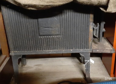 Flagstaff Hill Maritime Museum and Village
Domestic object - Wood Stove, circa 1880-1920
Stoves of this design are used for heating domestic places and were available in many designs and shapes. They commonly used wood as fuel and were not only used for heating but cooking as well. This stove was part of the original furnishings of the 1922 vessel 'Reginald M a South Australian costal trader it was made from material and fittings obtained from salvage yards. The vessel “Reginald M” was a two-masted coastal ketch, owned and built by Mr. Jack (John) Murch of Birkenhead, Port of Adelaide, South Australia. Its construction took approximately 6 months and it was launched at Largs Bay in 1922. Reginald M had a very shallow draft and a flat bottom that enabled it to come close to shore and to sit high and dry at low tide or to be beached on sand. The flat bottom was also to make the ship able to skim over reefs. Wagons could load and unload direct from her side. Her cargo included Guano, Barley, Wool, Horses, Cattle, Timber, Explosives, Potatoes, Shell Grit and Gypsum. On April 9th 1931Reginald M weathered a large storm in St Vincent Gulf, SA. The vessel suffered much damage; mast snapped and the crew labored for four hours to free her by chopping off the past and rigging. The crew patched her up and slowly returned to Port Adelaide with only a portion of the insured cargo being damaged. Her crew members at the time were owner Mr John H Murch of Wells Street Largs Bay, Skipper Mr R Murch John’s brother, Murray – son of Captain Murch and Seaman John Smith. Reg Webb purchased Carribie Station, at Marion in the Warooka District, south of Adelaide, in 1921. He cleared the land and farmed sheep and grain. In 1923 he shipped his own wool and grain from Marion Bay, having first carted 300 bags of the barley grain, 12 bags at a time, along the unmade track to the jetty. A photograph donated to Flagstaff Hill, dating about 1929 - 1942, shows two men on the Reginald M, holding between them their fishing catch of a large hammer shark. The photograph is stamped “GRENFELL STUDIO PORT LINCOLN PRINT” and titled “hammer shark caught on Reginald M”. The donor’s family lived on the Your Peninsular and dispatched their grain from a chute at Gleeson’s Landing to the awaiting transport vessel. Reg knew the Murch Brothers from Port Adelaide. The brothers had been using their ketch REGINALD M to ship Guano from the Islands, led by Captain Richard Murch. Reg approached them in 1934 about shipping grain from Marion Bay. The brothers visited the bay and thought it was an ideal place. They showed Reg where to stack his grain and they measured up the cliffs. When Reg was ready, they brought down and installed a ninety foot wooden chute. The bags of grain were then individually sent down the chute, landing in a waiting small boat then rowed to REGINALD M, 14 bags at a time. After 10 hours REGINALD M would be fully loaded with 1300 bags of grain and shipped to waiting ports. At one time a wild storm destroyed the chute but it was rebuilt and strengthened. REGINALD M was involved in shipping the grain from there until 1938. In 1940 Able Seaman Allan H Lucas served on Reginald M between September and December, being engaged and discharged from Port of Adelaide. His Certificate of Discharge was signed by ship’s Master W S Murch. It seems that at some stage Reginald M was used as a Customs vessel, as one photograph in Flagstaff Hill’s collection shows “H.M.C. No. 3, Pt Adelaide” on the bow. In 1969 the last freight left Marion Bay on the ketch REGINALD M carrying grain, wool and explosives. In late 1970 she was sold to the Mt. Lyell Mining and Railway Company and was used by them as a barge to carry explosives. In 1972 the Navy League of Strahan, Tasmania, purchased her for use by the Strahan Sea Cadet Unit to use at Macquarie Harbour and renamed her T.S. Macquarie. However this plan for use of Reginald M did not come to pass. In 1974 Mr. Andrew Rennie, of East Brighton, Melbourne, bought her for a similar purpose. , paying $5,000 and donating a ‘Cadet of the Year” trophy to the Sea Cadets. He sailed her from Strahan to Melbourne, planning to use her for pleasure sailing. In 1975 Reginald M was sold to Melbourne Ferry Company at auction. Later in 1975 the Reginald M was bought by Flagstaff Maritime Museum for $20,000 . She has been restored and is now one of the exhibits in the Village lagoon or lake. It was restored in 2006 using funds from a $4,000 government grant. Flagstaff Hill Maritime Village’s Collection holds several other artefacts associated with Reginald M. They include photographs of the Reginald M, including one photograph of her in Outer Harbour, S.A. dated 1947, with Skipper- R.F. Dale and Owner- John Murch. Another shows her docked at Port Adelaide, with the lettering H.M.C. No. 3 Pt ADEL (standing for His or Her Majesty’s Customs). The stove is significant as it represents the heating and cooking appliances used in late 19th and early 20th century, both on board vessels as well as for domestic purposes. The stove has additional significant for its association with the vessel "REGINALD M" a coastal trading ketch from South Australia built in 1922 at Largs Bay. It is one of very few sailing coastal trading vessels built in Australia with its flat bottom, single chine shape designed for navigating shallow water. See additional comments in the Production section this documents under Comments for further information regards the stove. Stove a cast-iron, rectangular, four-legged stove with a hinged front door. This stove was part of the original furnishings of the vessel 'Reginald M', built in Adelaide 1922. Image of a log cabin with an illegible inscription below it.flagstaff hil, warrnambool, flagstaff hill maritime museum, maritime museum, shipwreck coast, flagstaff hill maritime village, coastal trader, trading vessel, vessel reginald m, ketch, john murch ship builder, reg webb, carribie station, mt lyell copper company, queenstown navy league, andrew rennie, melbourne ferry company, r.f. dale, port adelaide vessel reginald m, macquarie training vessel, grenfell studio port lincoln, stove, domestic heating, domestic cooking, heater, cooking unit, wood fired stove, wood stove, wood-burning stove -
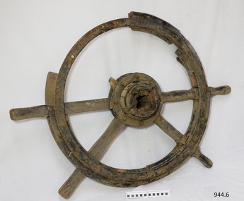 Flagstaff Hill Maritime Museum and Village
Equipment - Ship's Wheel, 1922
This ship's wheel was hand made from wood and metal using a recycled cart wheel. It originally belonged to the "Reginald M", a 2 masted, flat bottomed, coastal trading ketch with single chine. The REGINALD M The vessel “Reginald M” was a two-masted coastal ketch, owned and built by Mr. Jack (John) Murch of Birkenhead, Port of Adelaide, South Australia. Its construction took approximately 6 months and it was launched at Largs Bay in 1922. The Reginald M’s purpose was to serve the coastal trade of South Australia, to carry cargo cheaply and efficiently. It is believed that the keel was in fact hewn from two telegraph poles! Its builder frequented all the salvage yards for materials and fittings. Reginald M had a very shallow draft and a flat bottom that enabled it to come close to shore and to sit high and dry at low tide or to be beached on sand. The flat bottom was also to make the ship able to skim over reefs. Wagons could load and unload direct from her side. Her cargo included Guano, Barley, Wool, Horses, Cattle, Timber, Explosives, Potatoes, Shell Grit and Gypsum. On April 9th 1931Reginald M weathered a large storm in St Vincent Gulf, SA. The vessel suffered much damage; mast snapped and the crew laboured for four hours to free her by chopping off the past and rigging. The crew patched her up and slowly returned to Port Adelaide with only a portion of the insured cargo being damaged. Her crew members at the time were owner Mr John H Murch of Wells Street Largs Bay, Skipper Mr R Murch – John’s brother, Murray – son of Captain Murch and Seaman John Smith. Reg Webb purchased Carribie Station, at Marion in the Warooka District, south of Adelaide, in 1921. He cleared the land and farmed sheep and grain. In 1923 he shipped his own wool and grain from Marion Bay, having first carted 300 bags of the barley grain, 12 bags at a time, along the unmade track to the jetty. A photograph donated to Flagstaff Hill, dating about 1929 - 1942, shows two men on the Reginald M, holding between them their fishing catch of a large hammer shark. The photograph is stamped “GRENFELL STUDIO PORT LINCOLN PRINT” and titled “hammer shark caught on Reginald Emm”. The donor’s family lived on the Your Peninsular and despatched their grain from a chute at Gleeson’s Landing to the awaiting transport vessel. Reg knew the Murch Brothers from Port Adelaide. The brothers had been using their ketch REGINALD M to ship Guano from the Islands, led by Captain Richard Murch. Reg approached them in 1934 about shipping grain from Marion Bay. The brothers visited the bay and thought it was an ideal place. They showed Reg where to stack his grain and they measured up the cliffs. When Reg was ready, they brought down and installed a ninety foot wooden chute. The bags of grain were then individually sent down the chute, landing in a waiting small boat then rowed to REGINALD M, 14 bags at a time. After 10 hours REGINALD M would be fully loaded with 1300 bags of grain and shipped to waiting ports. At one time a wild storm destroyed the chute but it was rebuilt and strengthened. REGINALD M was involved in shipping the grain from there until 1938. In 1940 Able Seaman Allan H Lucas served on Reginald M between September and December, being engaged and discharged from Port of Adelaide. His Certificate of Discharge was signed by ship’s Master W S Murch. It seems that at some stage Reginald M was used as a Customs vessel, as one photograph in Flagstaff Hill’s collection shows “H.M.C. No. 3, Pt Adelaide” on the bow. In 1969 the last freight left Marion Bay on the ketch REGINALD M carrying grain, wool and explosives. In late 1970 she was sold to the Mt. Lyell Mining and Railway Company and was used by them as a barge to carry explosives. In 1972 the Navy League of Strahan, Tasmania, purchased her for use by the Strahan Sea Cadet Unit to use at Macquarie Harbour and renamed her T.S. Macquarie. However this plan for use of Reginald M did not come to pass. In 1974 Mr. Andrew Rennie, of East Brighton, Melbourne, bought her for a similar purpose. , paying $5,000 and donating a ‘Cadet of the Year” trophy to the Sea Cadets. He sailed her from Strahan to Melbourne, planning to use her for pleasure sailing. Also in 1975 Reginald M was sold to Melbourne Ferry Company at auction. Later in 1975 the Reginald M was bought by Flagstaff Maritime Museum for $20,000 . She has been restored and is now one of the exhibits in the Village lagoon or lake. It was restored in 2006 using funds from a $4,000 government grant. This ship's wheel is significant because of its association with the REGINALD M. REGNIALD M was a coastal trading ketch from South Australia built in 1922. It is one of very few sailing coastal trading vessels still extant, and its flat bottom, single chine shape illustrates a very simple but robust method of construction, compared to other round bilged examples of trading vessels. She is now listed on the Australian Register of Historic Vessels (ARHV Number: HV000562.)Ship’s wheel, also called a Helm, eight spoke design. Centre of wheel is handmade of wood and has iron rings around each side. The spokes are fitted into this wooden hub. The outer wheel has an iron ring on one side and sections of a wooden ring on the other. There are both original and modern bolt and screw fastenings. The wheel has remnants of black paint. This ship’s wheel was originally fitted to the ketch REGINALD M and removed during its restoration. flagstaff hill, warrnambool, shipwrecked-coast, flagstaff-hill, flagstaff-hill-maritime-museum, maritime-museum, shipwreck-coast, flagstaff-hill-maritime-village, ship's wheel, hand made ship's wheel, coastal trader, reginald m, ketch, john murch, ch murch, reg webb, carribie station, mt lyell copper company, queenstown navy league, andrew rennie, melbourne ferry company, r.f. dale -
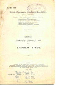 Ballarat Tramway Museum
Document - Engineering Standards, British Engineering Standards Association, Tramways
Set of nine Engineering standards that were acquired by ESCo during the 1920's. 2261.1 - British Engineering Standards Assoc. No. 101 - 1921, titled "British Standard Specification for Tramway Tyres" dated July 1921. 12pp + printed cover and a folded tip in sheet printed as plate 1, date stamped ESCo 14 Sep. 1923 - 216H x 141W, with "Tait Book Co. 90 William St. Melbourne" stamp on front cover. Light blue grey cover, with off white paper inside. Saddle stapled, rounded corners. Printed by Waterlow & Sons Limited, 49 Parliament Street Westminster SW1. See image 2261i1 for front cover. Publisher - Crosby Lockwood and Son London UK. - see images btm2261i1 and i2 for scans of the document. 2261.2 - British Engineering Standards Assoc. No. 2 - 1922, titled "British Standard Specification and Sections for Tramway Rails and Fishplates" dated March 1922. 56pp including cover, actual pages 35 - 50 are fold out sheets for plates 1 to 8 with rail sections detailed, date stamped ESCo 8 Jun 1926 - 216H x 142W, with "Tait Book Co. 90 William St. Melbourne" stamp on front cover. Light blue grey cover, with off white paper inside. Saddle stapled, rounded corners. Printed by Waterlow & Sons Limited, 49 Parliament Street Westminster SW1. Publisher - Crosby Lockwood and Son London UK. See image btm2261i3.pdf and i4.pdf 2261.3 -Australian Commonwealth Engineering Standards Association, Standard No. E 1a - 1926T - "Tentative Australian Standard Specifications for Railway Permanent Way Material", dated May 1926. 32pp plus cover, date stamped by ESCo 14 June 1926 - 229H x 157W saddle stapled. Grey cover with off white paper inside. Printed by The Australasian Medical Publishing Company Limited. See image 2261i2 for front cover. Publisher - The Association Sydney, Australia. See images i6 and i7 for a pdf scan of this document. 2261.4 - British Engineering Standards Assoc. No. 2 - 1927, proof issue, titled "British Standard Specification and sections for Tramway Rails and Fishplates" dated 1927. 56pp including cover, actual pages 35 - 50 are fold out sheets for plates 1 to 8, date stamped ESCo 16 Jul 1927 - 216H x 142W. Off white paper covers and text. Saddle stapled, rounded corners. Has "Waterlow" name on front cover bottom right hand corner. 2261.5 - Australian Commonwealth Engineering Standards Association, Standard No. C. 30 -1926T - "Tentative Australian Standard Specification for Drum Controllers and Resistances for use therewith for electric motors (DC and AC slip ring, excluding controllers for traction purposes", dated December 1926. 28pp plus cover, date stamped by ESCo 29 Jun 1927 - 227H x 152W. Grey cover with off white paper inside, saddle stapled. Printed by The Australasian Medical Publishing Company Limited. Publisher - The Association Sydney, Australia. 2261.6 - Australian Commonwealth Engineering Standards Association, Standard No. C 33 - 1926T - "Tentative Australian Standard Specifications for Drum Starters for electric motors", dated December 1926. 28pp plus cover, date stamped by ESCo 29 June 1927 - 227H x 153W. Grey cover with off white paper inside, saddle stapled. Printed by The Australasian Medical Publishing Company Limited. Publisher - The Association Sydney, Australia. 2261.7 - Australian Commonwealth Engineering Standards Association, Standard No. E 13 to 15 1927 T - "Tentative Australian Standard Specifications for Railway Rolling Stock Material, locomotive tyres, carriage wagon and tender tyres, weldless steel angle rings", dated August 1927. 32pp plus cover, date stamped by ESCo 15 Sep 1927 - 228H x 153W. Grey cover with off white paper inside, saddle stapled. Printed by The Australasian Medical Publishing Company Limited. Publisher - The Association Sydney, Australia. 2261.8 - Australian Commonwealth Engineering Standards Association, Standard No. E 22 to 29 1928 - "Australian Standard Specifications for Railway Permanent Way Material", dated January 1928. 64pp plus cover, date stamped by ESCo, but not readable - 228H x 153W. Light purple cover with off white paper inside, saddle stapled. Printed by The Australasian Medical Publishing Company Limited. Publisher - The Association Sydney, Australia. 2261.9 - British Engineering Standards Assoc. No. 101 - 1929, titled "British Standard Specification for Tramway Tyres" dated February 1929. 16pp +cover, pages 13 and 14 are foldout plate 1, held together with sewn thread, - 218H x 142W, with "J. Ewins & Sons, Booksellers and Stationers Ballarat" label on front cover. Light blue grey cover, with off white paper inside. Printed by Waterlow & Sons Limited, 49 Parliament Street Westminster SW1. Publisher - Crosby Lockwood and Son London UK. Yields information about British Tramway Standards which were used on Australian and New Zealand Tramways.Set of nine printed books, centre stapled. trams, tramways, standards, tramway equipment, tyres, permanent way, track materials, electric motors, esco -
 Tarnagulla History Archive
Photograph - Photograph: Company's Dam and Flour Mill, Tarnagulla, c. 1880 - 1920
Williams Family Collection. On the 20th December 1873 it was reported in the Tarnagulla Courier that arrangements were being made for the erection of a steam flour mill at Tarnagulla. Mr Bristol had purchased the necessary plant which would be erected with as little delay as possible. The site chosen was the premises occupied previously by Mr John Pierce, grocer and wine and spirit merchant, at the corner of King and Commercial Road. These premises were incorporated in the mill building. Suitable buildings for receiving and storing grain and flour had been erected already. On 10th January, 1874 an advertisement in the Courier called for tenders from masons, bricklayers and carpenters for the erection of a flour mill at Tarnagulla for H. C. Bristol, Esq. with all enquiries to be made from G. Minto, Engineer. In December 1881 the proprietors made a request to the Tarnagulla Borough Council for permission to lay pipes to the Municipal Dam, which was generally known as the Company's Dam, and to obtain water from the dam for milling purposes. This was granted. Steam was got up for the first time on 30th of March, 1882. A large quantity of wheat was stored ready for milling. Just prior to 29th of April 1882 the boiler at the mill burst, as the result of which two men, J. H. Smith and W. Hargreaves died and H. Joyce Bousfield, senior and junior, were seriously injured. The mill commenced operations on 13th June, 1882 with Mr W Fitzgerald as manager. The price offered for wheat was thirty-seven pence per bushell. It operated with grinding stones until considerable renovations were done in the early part of 1899 when new rollers and more up to date equipment installed. The mill was then known as the Tarnagulla Flour Mill Co., with Thos. Comrie as proprietor, Mr Fitzgerald was still manager, and Mr T. Leonard was the traveller. Much new equipment was put in and each of the three floors had different processes. The rollers were on the ground floor, the purifiers and elevators reel were on the second floor, plus the clean wheat bin directly over the Ganz rollers. On the top floor was the chop reel, bran reel, inter-elevator reels, brush machine cyclone sack hoist, dirty wheat shaker, clean wheat bin, dust rooms and also double damping rooms. A plant was also erected for the making of an improved quality of wheaten meal, for which purpose special machinery was procured and a pair of stones was left for grinding the meal. A complete plant for the crushing of oats etc was also erected. The driving power of the mill was supplied by a new engine complete with 16 inch cylinder, manufactured and erected by Bousfield & Co. of Eaglehawk. It was fitted with Pickering governors, connected with the cylinder was a super heater. The boiler was tested and all connections etc. overhauled, with much of it being completely renewed. There was a complete network of belts, spouts, elevators etc. all over the building, all conveniently placed. The plans etc for the new plant were drawn up by Mr J. Kilborn, manager of the firm of Bodington & Co., engineers and millwrights of Carlton, which supplied the whole of the machinery, excepting the engine. The work of erection was carried out by Mr Kilborn and his assistants to the entire satisfaction of Mr Comrie, who had gone to considerable expense to bring the mill to a completely up-todate machine, fitted with all of the most modern appliances available. An advertisement on May 6th, 1899 read: "Tarnagulla Flour Mill Co., Patent Roller Flour. Also their Digestive Wheaten Meal specially prepared for Porridge or Bread." In January 1901, 6000 bags of wheat were received weekly at the mill and it was a common sight to see the streets lined with wagons. In May 1902 the mill was lighted by gas and in July 1906 an application was made to the Tarnagulla Borough Council for permission to lay a tram track from the mill to the Railways Station. Council was agreeable to this provided suitable plans were submitted. In 1913, 15,000 bags of wheat were bought at three shillings and four pence per bushell. In January 1914 the mill was renovated. At this time 1500 bags of wheat were coming in daily, with 20,000 bags in storage. On 15th December, 1917 the mill was advertised for sale, to be sold on Friday, 21st December,.1917, on behalf of the Estate of the Late Thomas Comrie, who had died on 4th August, 1910. The Courier at that time recorded him as being responsible for the building of the mill and with being the sole proprietor. The mill was closed, apparently, for a short period. The Courier reported on 13th of September, 1918 that the mill had been sold to Mr O. Albert of Talbot and that it would re-open. An advertisement read: ALBERT. O. & SON, MILLERS. During 1920 the mill was closed and pulled down. It was later re-erected at Mildura where it operated for many years. (by Donald Clark)Monochrome photograph depicting view of Company's Dam and the flour mill in Tarnagulla. Handwritten on reverse: 'J. Caldwell and photographer's stamp 'C. Bock Photo Tarnagulla'.tarnagulla -
Tarnagulla History Archive
Postcard - Photographic postcard: Company's Dam and Flour Mill, Tarnagulla, c. 1880 - 1920
Williams Family Collection. On the 20th December 1873 it was reported in the Tarnagulla Courier that arrangements were being made for the erection of a steam flour mill at Tarnagulla. Mr Bristol had purchased the necessary plant which would be erected with as little delay as possible. The site chosen was the premises occupied previously by Mr John Pierce, grocer and wine and spirit merchant, at the corner of King and Commercial Road. These premises were incorporated in the mill building. Suitable buildings for receiving and storing grain and flour had been erected already. On 10th January, 1874 an advertisement in the Courier called for tenders from masons, bricklayers and carpenters for the erection of a flour mill at Tarnagulla for H. C. Bristol, Esq. with all enquiries to be made from G. Minto, Engineer. In December 1881 the proprietors made a request to the Tarnagulla Borough Council for permission to lay pipes to the Municipal Dam, which was generally known as the Company's Dam, and to obtain water from the dam for milling purposes. This was granted. Steam was got up for the first time on 30th of March, 1882. A large quantity of wheat was stored ready for milling. Just prior to 29th of April 1882 the boiler at the mill burst, as the result of which two men, J. H. Smith and W. Hargreaves died and H. Joyce Bousfield, senior and junior, were seriously injured. The mill commenced operations on 13th June, 1882 with Mr W Fitzgerald as manager. The price offered for wheat was thirty-seven pence per bushell. It operated with grinding stones until considerable renovations were done in the early part of 1899 when new rollers and more up to date equipment installed. The mill was then known as the Tarnagulla Flour Mill Co., with Thos. Comrie as proprietor, Mr Fitzgerald was still manager, and Mr T. Leonard was the traveller. Much new equipment was put in and each of the three floors had different processes. The rollers were on the ground floor, the purifiers and elevators reel were on the second floor, plus the clean wheat bin directly over the Ganz rollers. On the top floor was the chop reel, bran reel, inter-elevator reels, brush machine cyclone sack hoist, dirty wheat shaker, clean wheat bin, dust rooms and also double damping rooms. A plant was also erected for the making of an improved quality of wheaten meal, for which purpose special machinery was procured and a pair of stones was left for grinding the meal. A complete plant for the crushing of oats etc was also erected. The driving power of the mill was supplied by a new engine complete with 16 inch cylinder, manufactured and erected by Bousfield & Co. of Eaglehawk. It was fitted with Pickering governors, connected with the cylinder was a super heater. The boiler was tested and all connections etc. overhauled, with much of it being completely renewed. There was a complete network of belts, spouts, elevators etc. all over the building, all conveniently placed. The plans etc for the new plant were drawn up by Mr J. Kilborn, manager of the firm of Bodington & Co., engineers and millwrights of Carlton, which supplied the whole of the machinery, excepting the engine. The work of erection was carried out by Mr Kilborn and his assistants to the entire satisfaction of Mr Comrie, who had gone to considerable expense to bring the mill to a completely up-todate machine, fitted with all of the most modern appliances available. An advertisement on May 6th, 1899 read: "Tarnagulla Flour Mill Co., Patent Roller Flour. Also their Digestive Wheaten Meal specially prepared for Porridge or Bread." In January 1901, 6000 bags of wheat were received weekly at the mill and it was a common sight to see the streets lined with wagons. In May 1902 the mill was lighted by gas and in July 1906 an application was made to the Tarnagulla Borough Council for permission to lay a tram track from the mill to the Railways Station. Council was agreeable to this provided suitable plans were submitted. In 1913, 15,000 bags of wheat were bought at three shillings and four pence per bushell. In January 1914 the mill was renovated. At this time 1500 bags of wheat were coming in daily, with 20,000 bags in storage. On 15th December, 1917 the mill was advertised for sale, to be sold on Friday, 21st December,.1917, on behalf of the Estate of the Late Thomas Comrie, who had died on 4th August, 1910. The Courier at that time recorded him as being responsible for the building of the mill and with being the sole proprietor. The mill was closed, apparently, for a short period. The Courier reported on 13th of September, 1918 that the mill had been sold to Mr O. Albert of Talbot and that it would re-open. An advertisement read: ALBERT. O. & SON, MILLERS. During 1920 the mill was closed and pulled down. It was later re-erected at Mildura where it operated for many years. (by Donald Clark)Photographic postcard, front image depicting view of Company's Dam and the flour mill in Tarnagulla. Handwritten on reverse: 'A Merry Christmas and a Happy New Year, E. Bool' and photographer's stamp 'C. Bock Photo Tarnagulla'.tarnagulla -
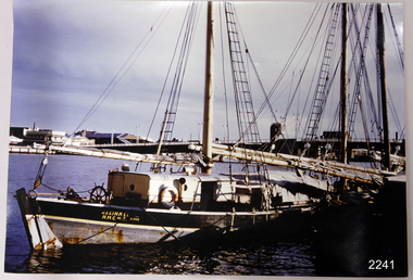 Flagstaff Hill Maritime Museum and Village
Photograph
This coloured photograph of the ketch Reginald M was taken when she was docked at Port Adelaide. The side of the vessel shows the letters "REGINALD M / H.M.C. No. 2 Pt ADEL" - (abbreviation H.M.C. meaning His/Her Majesty's Customs. HISTORY The Reginald M, a two-masted coastal ketch, was owned and built by Mr. Jack (John) Murch of Birkenhead, Port of Adelaide, South Australia to serve the coastal ports of South Australia. Its construction took approximately 6 months and it was launched at Largs Bay in 1922. Its purpose was to carry cargo cheaply and efficiently, and tradition has it that the keel was in fact hewn from two telegraph poles! Its builder frequented all the salvage yards for materials and fittings. The Reginald M had a very shallow draft and a flat bottom that enabled it to sit high and dry at low tide. The flat bottom was also to make the ship able to skim over reefs. Wagons were able to load and unload direct from her side. Her cargo included Guano, Barley, Wool, Horses, Cattle, Timber, Explosives, Potatoes, Shell Grit and Gypsum. In 1931 she weathered a large storm in St Vincents Gulf, SA. Her crew at the time were Owner Mr John H Murch, Wells St, Largs Bay, Skipper, John’s brother Mr R Murch, Murray, son of Mr R Murch and Seaman John Smith Reg Webb purchased Carribie Station, at Marion in the Warooka District, south of Adelaide, in 1921. He cleared the land and farmed sheep and grain. In 1923 he shipped his own wool and grain from Marion Bay, having first carted 300 bags of the barley grain, 12 bags at a time, along the unmade track to the jetty. A photograph dating about 1929 -1942 shows 2 men on the Reginald M, having just landed their fishing catch of a hammer shark. The photograph is stamped “GRENFELL STUDIO PORT LINCLON PRINT” and titled “hammer shark caught on Reginall Emm”. Reg Webb knew the Murch Brothers from Port Adelaide. The brothers had been using their ketch REGINALD M to ship Guano from the Islands, led by Captain Richard Murch. Reg approached them in 1934 about shipping grain from Marion Bay. The brothers visited the bay and thought it was an ideal place. They showed Reg where to stack his grain and they measured up the cliffs. When Reg was ready, they brought down and installed a ninety foot wooden chute. The bags of grain were then individually sent down the chute, landing in a waiting small boat then rowed to REGINALD M, 14 bags at a time. After 10 hours REGINALD M would be fully loaded with 1300 bags of grain and shipped to waiting ports. At one time a wild storm destroyed the chute but it was rebuilt and strengthened. REGINALD M was involved in shipping the grain from there until 1938. In 1940 Able Seaman Allan H Lucas served on Reginald M between September and December, being engaged and discharged from Port of Adelaide. His Certificate of Discharge was signed by ship’s Master W S Murch. It seems that at some stage Reginald M was used as a Customs vessel because a photograph in Flagstaff Hill’s collection shows the text “H.M.C. No. 3, Pt Adelaide” on the bow, the abbreviations standing for “His/Her Majesty’s Customs”. In 1969 the last freight left Marion Bay on the ketch REGINALD M carrying grain, wool and explosives. In late 1970 she was sold to the Mt. Lyell Copper Company, based in Queenstown, Tasmania, to carry explosives. In 1972 the Navy League of Strahan, Tasmania, purchased her for use by the Strahan Sea Cadet Unit and renamed her T.S. Macquarie. In 1974 Mr. Andrew Rennie, of East Brighton, Melbourne, bought her, paying $5,000 and donating a ‘Cadet of the Year” trophy to the Sea Cadets. He sailed her from Strahan to Melbourne, planning to use her for pleasure sailing. In 1975 Reginald M was sold to Melbourne Ferry Company at auction. In 1975 the Reginald M was bought by Flagstaff Maritime Museum for $20,000. She has been restored and is now one of the exhibits, tied up at the dock. Flagstaff Hill Maritime Village’s Collection holds several other artefacts associated with Reginald M. They include - Photographs of the Reginald M, including one photograph of her in Outer Harbour, S.A. dated 1947, with Skipper- R.F. Dale and Owner- John Murch. Another shows her docked at Port Adelaide, with the lettering H.M.C. No. 3 Pt ADEL (standing for His/Her Majesty’s Customs). There is a black and white photo of her at a wharf and another showing a person on board. - a lifebuoy, with Pt Adelaide on it. - a bullet found in pieces of timber when Reginald M was restored in 1979 (References: Flagstaff Hill Fact Sheet “Reginald M”, the book “The Reg Webb Story” compiled by the Warooka & District Museum. Reg Webb’s daughter Lily Ramsay (nee Webb) and her husband Howard, Lizzie Rennie (daughter of owner Andrew Rennie), brochure “Discover the Yorke Peninsula South Australia”, Ketch in Peril; Adelaide Chronicle 9 April 1931, K Gordon & Mary Filmer of Warooka; South Australian Maritime Museum) Thiis photograph is significant because of its connection to the history of the vessel REGINALD M is a coastal trading ketch from South Australia built in 1922. It is one of very few sailing coastal trading vessels still extant, and its flat bottom, single chine shape illustrates a very simple but robust method of construction, compared to other round bilged examples of trading vessels. She is now listed on the Australian Register of Historic Vessels (ARHV Number: HV000562.)Photograph of Reginald M at Port Adelaide. The side of the vessel shows the letters "REGINALD M / H.M.C. No. 2 Pt ADEL" - (abbreviation H.M.C. meaning His/Her Majesty's Customs. Painted on the side of the vessel "REGINALD M / H.M.C. No. 2 Pt ADEL" - flagstaff hill, warrnambool, shipwrecked-coast, flagstaff-hill, flagstaff-hill-maritime-museum, maritime-museum, shipwreck-coast, flagstaff-hill-maritime-village, reginald m, coastal trading ketch, trading vessel, john murch ship builder, port adelaide vessel reginald m, andrew rennie, macquarie training vessel, mt lyell copper company, queenstown navy league, ch murch, reg webb, carribie station, melbourne ferry company, grenfell studio port lincoln, vessel reginald m -
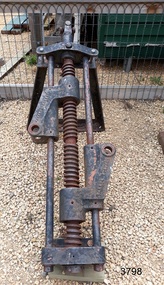 Flagstaff Hill Maritime Museum and Village
Machine - Steering Gear, Carron Ironworks foundry, before 1922
The ship's steering gear was used for steering and navigation of a vessel - it was a very important part of the ship's equipment. This steering gear was part of the original vessel 'Reginald M', which became part of the exhibitions at Flagstaff Hill Maritime Village. The steering gear was manufactured by the Carron Company. ABOUT THE CARRON COMPANY The Carron Company established its ironworks on the banks of the River Carron in Stirlingshire, Scotland, in 1759, and became an incorporated company in 1773. One of the notable items produced by the company was the Carronade, a short-barrelled naval cannon, being produced until the 1850s. The company was the largest ironworks in Europe during the 19th century. It supplied ammunition and armaments, steamboat engines, pig iron, cast iron goods such as balustrades fire grates and bath tugs, pillar boxes and telephone boxes, and even cast iron rings for underground tunnels. In 1982 it became insolvent and was taken over by the Franke Corporation, using the brand Carron Phoenix. ABOUT THE 'REGINALD M' The Reginald M’s purpose was to serve the coastal trade of South Australia, to carry cargo cheaply and efficiently. It is believed that the keel was in fact hewn from two telegraph poles! Its builder frequented all the salvage yards for materials and fittings. The vessel “Reginald M” was a two-masted coastal ketch, owned and built by Mr. Jack (John) Murch of Birkenhead, Port of Adelaide, South Australia. Its construction took approximately 6 months and it was launched at Largs Bay in 1922. Reginald M had a very shallow draft and a flat bottom that enabled it to come close to shore and to sit high and dry at low tide or to be beached on sand. The flat bottom was also to make the ship able to skim over reefs. Wagons could load and unload direct from her side. Her cargo included Guano, Barley, Wool, Horses, Cattle, Timber, Explosives, Potatoes, Shell Grit and Gypsum. On April 9th 1931Reginald M weathered a large storm in St Vincent Gulf, SA. The vessel suffered much damage; mast snapped and the crew laboured for four hours to free her by chopping off the past and rigging. The crew patched her up and slowly returned to Port Adelaide with only a portion of the insured cargo being damaged. Her crew members at the time were owner Mr John H Murch of Wells Street Largs Bay, Skipper Mr R Murch – John’s brother, Murray – son of Captain Murch and Seaman John Smith. Reg Webb purchased Carribie Station, at Marion in the Warooka District, south of Adelaide, in 1921. He cleared the land and farmed sheep and grain. In 1923 he shipped his own wool and grain from Marion Bay, having first carted 300 bags of the barley grain, 12 bags at a time, along the unmade track to the jetty. A photograph donated to Flagstaff Hill, dating about 1929 - 1942, shows two men on the Reginald M, holding between them their fishing catch of a large hammer shark. The photograph is stamped “GRENFELL STUDIO PORT LINCOLN PRINT” and titled “hammer shark caught on Reginald Emm”. The donor’s family lived on the Your Peninsular and despatched their grain from a chute at Gleeson’s Landing to the awaiting transport vessel. Reg knew the Murch Brothers from Port Adelaide. The brothers had been using their ketch REGINALD M to ship Guano from the Islands, led by Captain Richard Murch. Reg approached them in 1934 about shipping grain from Marion Bay. The brothers visited the bay and thought it was an ideal place. They showed Reg where to stack his grain and they measured up the cliffs. When Reg was ready, they brought down and installed a ninety foot wooden chute. The bags of grain were then individually sent down the chute, landing in a waiting small boat then rowed to REGINALD M, 14 bags at a time. After 10 hours REGINALD M would be fully loaded with 1300 bags of grain and shipped to waiting ports. At one time a wild storm destroyed the chute but it was rebuilt and strengthened. REGINALD M was involved in shipping the grain from there until 1938. In 1940 Able Seaman Allan H Lucas served on Reginald M between September and December, being engaged and discharged from Port of Adelaide. His Certificate of Discharge was signed by ship’s Master W S Murch. It seems that at some stage Reginald M was used as a Customs vessel, as one photograph in Flagstaff Hill’s collection shows “H.M.C. No. 3, Pt Adelaide” on the bow. In 1969 the last freight left Marion Bay on the ketch REGINALD M carrying grain, wool and explosives. In late 1970 she was sold to the Mt. Lyell Mining and Railway Company and was used by them as a barge to carry explosives. In 1972 the Navy League of Strahan, Tasmania, purchased her for use by the Strahan Sea Cadet Unit to use at Macquarie Harbour and renamed her T.S. Macquarie. However this plan for use of Reginald M did not come to pass. In 1974 Mr. Andrew Rennie, of East Brighton, Melbourne, bought her for a similar purpose. , paying $5,000 and donating a ‘Cadet of the Year” trophy to the Sea Cadets. He sailed her from Strahan to Melbourne, planning to use her for pleasure sailing. Also in 1975 Reginald M was sold to Melbourne Ferry Company at auction. Later in 1975 the Reginald M was bought by Flagstaff Maritime Museum for $20,000 . She has been restored and is now one of the exhibits in the Village lagoon or lake. It was restored in 2006 using funds from a $4,000 government grant. Flagstaff Hill Maritime Village’s Collection holds several other artefacts associated with Reginald M. They include photographs of the Reginald M, including one photograph of her in Outer Harbour, S.A. dated 1947, with Skipper- R.F. Dale and Owner- John Murch. Another shows her docked at Port Adelaide, with the lettering H.M.C. No. 3 Pt ADEL (standing for His/Her Majesty’s Customs). There is a black and white photo of her at a wharf and another showing a person on board.The steering gear is significant through its association with the Carron Company, the largest ironworks in Europe in the 19th century, and the manufacture of the short barrel, lightweight naval gun - the Carronade. The steering gear is significant for its association with the vessel REGINALD M is a coastal trading ketch from South Australia built in 1922. It is one of very few sailing coastal trading vessels still extant, and its flat bottom, single chine shape illustrates a very simple but robust method of construction, compared to other round bilged examples of trading vessels. She is now listed on the Australian Register of Historic Vessels (ARHV Number: HV000562.) Ship's steering gear that was part of the original vessel 'Reginald M', which was constructed in 1922. Inscription on both sides. Made by the Carron Company, UK."CARRON COMPANY"flagstaff hil, warrnambool, shipwrecked coast, flagstaff hill maritime museum, maritime museum, shipwreck coast, flagstaff hill maritime village, coastal trader, trading vessel, vessel reginald m, ketch, john murch ship builder, reg webb, carribie station, mt lyell copper company, queenstown navy league, andrew rennie, melbourne ferry company, r.f. dale, port adelaide vessel reginald m, macquarie training vessel, grenfell studio port lincoln, ship steering gear, metal steering gear, ship's gear, ship's navigation, carron company -
 Flagstaff Hill Maritime Museum and Village
Photograph - Vessels - Sail and Steam, c. 1972-1975
Andy Clapham owned and operated a boat yard on the Maribyrnong River in Footscray, Victoria. The river runs into Port Phillip Bay (sometimes known as Hobson’s bay) at Williamstown, an area with a history of trades associated with the shipping and construction industry. Andy Clapham’s photographs include those of the Reginald M and one of Polly Woodside, another vessel restored and used as a maritime exhibition. Andy Clapham’s letter of 1972 was posted in a and envelope with an early Australian decimal currency stamp showing the profile portrait of Queen Elizabeth II, and valued at 7 cent. Andy offered invaluable advice to the Flagstaff Hill Historic Park Planning Board regarding the purchase a vessel suitable for use as an exhibit once Flagstaff Hill was opened. The Planning Board was set up by the Warrnambool Chamber of Commerce and approved by the City Council and State Government. Flagstaff Hill was investigating vessels in Adelaide and Tasmania as well as Melbourne. Andy looked at several vessels in 1972-1973. He also serviced the Reginald M among other vessels belonging to Captain Julian Dyson of Yarra Ferries, who had casually offered the vessel to Flagstaff Hill as a price that was unattainable at the time. Flagstaff Hill later requested photographs of the hull to discern the dimensions and also the condition of the timbers as well as wanting advice on its seafaring capability. In 1972 the Flagstaff Hill Historic Park Planning Board – Chairman J. (John) S. Lindsay (1972-1980), Secretary J. (James) Mark – wrote a letter of appreciation to Mr A. (Andy) Clapham of 3 Charles Street Footscray ... “Dear Mr. Clapham, The Board has asked me to write to you to express our appreciation for the assistance you have offered us through our Chairman John Lindsay. The information you have already given us has been invaluable, in that is shows us that we have not been setting out to do something that is impossible. We look forward to receiving further information from you as it becomes available and we appreciate that you must be busy enough without our problems. Members of our Board hope to call and see you on a trip to Melbourne in the near future. The Board is optimistic about the future of Flagstaff Hill as a Maritime Museum and look forward to you visiting Warrnambool to examine what we believe will be an ideal site. Yours faithfully, James Mark.” ABOUT the vessel “Reginald M” The vessel “Reginald M” was a two-masted, timber coastal vessel built by John Henry Murch in Birkenhead, Port of Adelaide, South Australia. It was named after Reginald Murch. (It was occasionally referred to as the Reginald “Emm”). Its construction took approximately 6 months using many materials and fittings from salvage yards. It is believed that the keep was hewn from two telegraph poles! Reginald M was launched at Largs Bay in 1922. Reginald M was approximately 30 metres long and was fore-to-aft ketch rigged with an ‘auxiliary’ motor to support any loss of sail power. The Reginald M was built to service the coastal ports of South Australia to Port Victoria on the York Peninsular, Spencer Gulf. It freighted cargo from port to port cheaply and efficiently. It had a very shallow draft and a flat bottom, enabling it to come close to shore and sit high and dry at low tide, or to be beached on the sand. It could easily skim over reefs due to its flat bottom. Wagons could be loaded and unloaded directly from the side of the vessel. Over the years her cargo included guano, barley, wool, horses, cattle, timber, explosives, potatoes, shell grit and gypsum. The Murch brothers from Port Adelaide were owners of the Reginald M and Richard Murch as the Captain. On April 9, 1931, Reginald M weathered a large storm in St. Vincents Gulf, SA, suffering much damage; the mast snapped and the crew laboured for four hours to free it up by severing the mast and rigging. The crew patched it up and slowly returned to Port Adelaide with only a portion of the insured cargo being damaged. The crew members at that time were owner Mr John Henry Murch of Wells Street Largs Bay, Skipper Mr R Murch – John’s brother, Murray – son of Captain Murch and Seaman John Smith. At some stage it seems that the Reginald M was used as a Customs vessel “H.M.C. No. 3, Pt Adelaide” as shown in a photograph in Flagstaff Hill’s collection. In 1969 Reginald M’s last freight trip left Marion Bay, carrying grain, wool and explosives. In late 1970 it was sold to the Mount Lyall Mining and Railway Clompany and used as a barge to carry explosives. In 1972 The Navy League of Strahan, Tasmania, purchased the vessel for use by the Strahan Sea Cadet Unit at Macquarie Harbour; it was renamed “T.S. Macquarie”. (This plan did not come to pass.) In 1974 Mr Andrew Rennie of East Brighton, Melbourne, brought Reginald M for shipping purposes, He sailed it from Strahan to Melbourne, planning to use it for pleasure sailing. The Reginald M was later sold at auction to Captain Julian Dyson, owner of Yarra Passenger Ferries in Melbourne. Later in 1975 funds became available to Flagstaff Hill Maritime Village to purchase the Reginald M. It was then restored and used as an exhibit here for many hears. Flagstaff Hill’s collection also includes various objects related to the Reginald M: - Photographs of Reginald M over the years in various aspects of its use - a life buoy with the inscription of “Pt. Adelaide” - helm section that was removed and replaced during restoration - a bullet found in pieces of timber during the 1979 restoration ABOUT THE POLLY WOODSIDE On the bow in the Polly Woodside's photograph is the word "RONA". the Polly Woodside was built at Belfast in 1885. In 1904 the vessel was sold to A.H. Turnbull of New Zealand and renamed "RONA". The letter and photographs are significant for their association with the Reginald M, an Australian built coastal trader now on the Australian Register of Historic Vessels (number HV000562). The letter and photographs are also significant as part of both the history of Flagstaff Hill and the history of the vessel “Reginald M” that has been on display in the lake for many years. Objects retained from this boat are included in Flagstaff Hill’s collection of maritime history.Packet with photographs and negatives in a KODAK envelope. The photographs are of two sail and steam vessels; twelve (12) black and white photographs of the 'Reginald M', and one (1) colour photograph of the Polly Woodside, plus six (6) negative strips. Included int he packet is a letter in stamped and postmarked envelope addressed to Mr A Clapham of Footscray. The envelope postmarked 9 Dec 1972, with the Warrnambool postcode 3280, A 7c Australian postage stamp in attached to the envelope. They are associated with Flagstaff Hill’s acquisition of the vessel “Reginald M”. Envelope "9 DEC 1972 / 3280" Postage stamp "7c" "Australia" Inscriptions on one Reginald M;; "REGINALD M" and "Pt ADELAIDE H.M.C. No. 3" Inscriptions of the Polly Woodside; "RONA / MSC" "MHI / NO. 1" Ball point ink, reverse of photograph "POLLY WOODSIDE"flagstaff hill, warrnambool, shipwrecked coast, flagstaff hill maritime museum, maritime museum, shipwreck coast, flagstaff hill maritime village, great ocean road, vessel reginald m, reginald emm, t. s. macquarie, h.m.c. no. 3, pt adelaide, australian register of historic vessels (number hv000562), boat building trade, jack murch, john henry murch, birkenhead, port adelaide sa, largs bay sa, coastal trader south australia, 1920 ketch reginald m, marion bay produce, mount lyall mining and railway company, navy league of strahan, tasmania, melbourne ferry company, flagstaff hill historic park planning board, john lindsay, james mark, andy clapham of footscray, andy clapham boat builder, kodak photograph packet envelope, kodak super-size prints, kodak australia pty ltd, australian postage stamp 1972 - 7c -
 Ballarat Tramway Museum
Ephemera, Wal Jack, Wal Jack notebook, 1940's
Demonstrates Wal Jack's records, hand written in a recycled notebook. Note - several sheets have been cut from the book - appear to be done before use by Wal. The crossed out sheets have not been imaged - these have been transferred by Wal to Reg Item 5507 and re-ordered. Image 30 shows a sample of a crossed out page. See related documents for a pdf file of the contents. Scan No. BTM5623iX Page No. Title or Subject Notes 1 Front 2 Inside Cover Addresses for Jack McLean, John Buckland Trooper Larsen Inside front cover. 3 1 Note re NSWT steam tram motor, MMTB PCC import issues, Peter Duckett seeking info and Photo of Julien’s battery tram on test in Melbourne 4 2 MMTB No. 8, 4, photos, Tyrell’s of Sydney photos, Perth 63 dimensions and MMTB plans for Domain Road & St Kilda Rd Jtn. 5 3 Notes re NSWGR P32, VR locos at Wodonga 13/10/1941, SAR V Class V143, SAR locos – W and Wx 6 4 NSW Private locos, Woy Woy quarry and AGL at Mortlake 5 Blank 6 Blank 7 7 First cable trams – links to photos T154, 29, 154 (Adelaide) 8 8 T156, Powelltown, Ray Pearson Negs 9 9 QR B18 ¼ locos, Ray Pearson’s scrap book, PMTT Zeppelin style trams, MMTB T class locations and 178/179 rebuilding. 10 10 Hawthorn horse tramway, VR Black Rock terminus sketch 11 11 NSW Tramways, Ryde, MMTB L class, Geelong tramway notes 12 12 Locomotive “Ballarat” in WA, Brisbane and various contacts. 13 13 Notes re VR News – 1943, H class, derailments, max speeds, Koondrook tramway and Geelong level crossing. Individual typed sheets pasted onto page – loose within book. 14 to 17 14/17 List of MMTB trams to 877 and work trams Some errors noted. 18 18 Newspaper cutting – Tram Record Day revenue (Brisbane 10/1943), Steam Trams at Journey’s end – Sydney – 6/1943 list of equipment being sold by Sydney Ferries, at Parramatta, 6/1943. MMTB Tram crossings in Melbourne, list of Sydney photos sent to Wal. Cuttings and Individual typed sheets pasted onto page. 19 19 Midland locos WA, VR open wagon stencils and a siding at Mt. Evelyn. Individual typed sheets pasted onto page. 20 20 Note re Sydney four wheel tourist trams and Hawthorn Max. Traction cars locations c1945. 21 to 23 21/23 Notes on Geelong Bogie trams and carrying flags for declaration of Newtown and Chilwell as a city – 1/10/1949 (See also Reg Item 5641) 24 to 26 24/26 Notes on Wellington Corporation Tramcars 37 27 Kelburn – Karoi cable line Wellington 28 to 29 28/29 Auckland Tramway Board tramcars notes 30/31 Blank 30 32/33 Notes on Ballarat tramcars – ESCo Crossed out 34/37 Ditto – SEC Crossed out 38 Music for the people notes Crossed out 39 Notes on Ballarat trams with tail lights Crossed out 40/43 Notes on Ballarat bogie trams Crossed out 44/45 Notes on SEC tram controllers, dead man and truck lengths. Crossed out 31 45 List of Ballarat Destination roll – Dec 1949 32, 33 46/47 Notes on Bendigo Bogie Trams – 1940’s 34 48 Bendigo Destination roll on a Birney tram Easter 1950, notes on tram tail lights and fares on the Bendigo system. 49 Blank – though headed “Bendigo Birney Trams” 50 Notes trams used on special days in Ballarat Crossed out 51 Ditto and No. 24 and 23 Crossed out 52 Ditto, 15, 11, 23 and Gold tram Crossed out 53 Notes on 34 caused delays, 5/1950, and use of 23 as gold tram Crossed out 54 Notes on repair to track at Sturt and Drummond 6/1951 Crossed out - see Reg Item 7720. 55 Notes on track work in Ballarat early 1950’s Crossed out 56/57 Notes on 33, 37, pay as you enter signs and 1953 special workings Crossed out 58/60 Notes trams used on special days in Ballarat Crossed out 61/64 Blank 35 65 “Salute to the Cable Tram” – transcription of text from Truck and Bus Transportation (July 1948) 36, 37 66/67 Continued from above and list cable tram routes, opening, closing, length and route colours. 38 68 List of photos in Truck and Bus Transportation, Anniversary Issue July 1948 of cable trams. 69 Blank 39 70 Notes on Brunswick TT, Fitzroy TT colours, Adelaide Service trams and MMTB route lengths. 40 71 Notes on HTT colours, tramcars, PMTT trams and colours and NMETL colours, trams and route destination signs 41 72 Notes on MMTB routes, cable and other Melbourne tram disposals, and sale of cable trams and storage at Brunswick. 42 73 Blank - page was headed Lugarno, Switzerland and Italian border 42 Handwritten sheet – photos to get – R. Field and Peter Duckett. 43, 44 74/75 Listing of trains on all lines leaving Ballarat and days run. 45 77 Listing of negatives sent to K. Rogers in 1944 and list of MMTB Max. Traction bogie trams 117 to 138 and disposal 46 77 Listing of MMTB trams, - appears to be something to do with photos or negs held. 47 78 Listing of Ray’s (Pearson) negs /photos of Brisbane trams and other railway photos. 79 Blank 48 80 Prices of pine timber in 4/1942, list of photos “I want”, notes re VR Train length, Ironbark Gully bridge, 3817 in Harden smash 7/1948 and 1948 Ballarat destination roll. Partly crossed out. Rear Cover. Has a strong association with Wal Jack, his work to collect and record both railway and tramway information. Yields information about tramways in Ballarat, Bendigo, Geelong and other cities tramways and railways.Grey covered book with black binding containing 40 lined sheets (80 pages) with handwritten notes with the front cover partly cut out and the words "Jewellery & Engraving" book written in. Contains some newspaper clippings and pasted typed notes as listed below. The image number of each sheet is given. See individual pdf files. trams, tramways, mmtb, ballarat, bendigo, sydney, brisbane, railways, geelong, new zealand, victorian railways, sec, esco -
 Eltham District Historical Society Inc
Photograph - Digital Photograph, Alan King, Graves of Thomas Sweeney and family, Eltham Cemetery, Victoria, 27 January 2008
The grave of Thomas Sweeney, former convict turned respectable citizen. The Murray and Sweeney families were both early settlers of the Eltham district and connected by marriage. Their family plots are located side by side in the Catholic section of the Eltham Cemetery. Irish-born Thomas Sweeney is regarded as the first settler in Eltham. He was transported to Sydney in 1823 after being convicted of arson. He was granted his freedom in 1838 and married Margaret Meehan in the same year. They moved to Melbourne and in 1842 Thomas purchased 110 acres beside the Yarra River in the vicinity of present-day Sweeneys Lane. He called the property ‘Culla Hill’ and built a small slab hut (reputedly with Wurundjeri help; Margaret is said to have run an informal hospital for them in return). This was followed in 1846 by more substantial buildings consisting of a three-roomed Irish-style ‘longhouse’ and a barn made of stone and handmade bricks, with doors large enough to accommodate a fully loaded wagon. When the gold rush came, Thomas prospered by selling meat and potatoes to the prospectors, enabling him to purchase a further 308 acres in 1856. He promoted the construction of a bridge over the Plenty River and the establishment of a school at Eltham. Roman Catholic Church services were held at Culla Hill in the early years. When he died in 1867, he was regarded as a respected member of the community. Thomas and Margaret are buried in Eltham Cemetery with many of their descendants. Their first son John continued to farm Culla Hill until his death in 1909. Culla Hill passed out of the Sweeneys' possession in 1939. The house and barn remain today, though lesser outbuildings have gone. The facade of the house is much the same as it was in the 1840s. Sacred To the memory of Thomas Sweeney Who died Sep 6th 1867 Aged 65 years May his soul res in peace Also his wife Margaret Died Oct 3rd 1884 aged 73 years And their daughters Annie Died Aug 22nd 1860 aged 21 years Johanna Died Aug 19th 1872 aged 22 years Margaret Died 7th Sep 1913 aged 72 years R.I.P. Also In Memory Of John Sweeney Died 24th May 1909 Aged 65 years Also of his wife Ellen Died 8th March 1910 Aged 64 years R.I.P Also In Memory Of Caroline Infant daughter of John & Ellen Sweeney Published: Nillumbik Now and Then / Marguerite Marshall 2008; photographs Alan King with Marguerite Marshall.; p55 From the piety and poverty of 19th century Eltham, 20th century artists and environmentalists, to today’s comfortable middle class, Eltham Cemetery records it all — and more. A visit to Eltham Cemetery reveals an important social record since its beginnings in 1858. The cemetery was situated on about six acres (2.4ha) (now around 4.8ha) at the corner of Mount Pleasant and Metery Roads.1* It is thought that Metery Road was originally called Cemetery Road, but in the early 1940s, a resident, possibly a councillor, objected to the name resulting in the change.2 Much can be gleaned about the developing Eltham community from burial styles and the names of former local residents. Originally the cemetery was divided into Christian denominations, like others of that time, following the United Kingdom burial system. In 1861 the cemetery included Church of England, Presbyterian, Roman Catholic and Wesleyans (later Methodist) sites. Graves also indicated social class. Some had grand tombstones, perhaps fenced with ornamental cast iron railing, but most in the 1860s and 1870s were constructed of modest stone slabs.3 This indicated the poverty of the district, which was largely inhabited by farmers on small landholdings. A poignant reminder of the high rates of infant mortality of those times, are the many infants and young children recorded on the headstones. Major changes occurred in the cemetery in the late 20th century as Christian adherence weakened and society became more egalitarian and informal. In the early 1970s a non-denominational lawn section for burials was established. Since then all new areas have been non-denominational to accommodate the more diverse local community. Now, instead of large ornamental headstones, some mourners have chosen boulders, reflecting the natural Eltham style, while others choose graves in the lawn areas or niches in walls. In the late 1970s, the University Donor Section was established north-west of Candlebark Lawn for those who donated their bodies for The University of Melbourne medical research. In the early 1980s the natural Australian garden style, popular in Eltham, was mirrored in a new section called Ashes Walk. Local landscape architect Gordon Ford, who had popularised this style, designed the Walk using boulders shaded by native plants beside curved pathways. Landscape architect Robert Boyle later redesigned Ashes Walk and developed other parts of the cemetery in keeping with this style.4 Appropriately Ford, who died in 1999, was interred in the Native Garden Section in a cluster of sites shaded by a large eucalyptus tree.5 By 2007, about 6400 interments were recorded in the Eltham Cemetery. Close inspection reveals notable names in the district’s history. The grave of Thomas Sweeney, a former convict who became a respected citizen, can be found in the Roman Catholic section near the path. Eltham Primary School’s first headmaster, David Clark, is buried in a modest grave in the Church of England section to the east of the path from the main entrance. Sir William Irvine, Victorian Premier from 1900 to 1902, whose grave is in the north-east Presbyterian section was at various times Victoria’s Chief Justice, Deputy Governor and Treasurer.6 Further south is the grave of social reformer Bertram Wainer, born in Scotland in 1928 and died in 1987. He campaigned to legalise abortion and exposed police corruption in allowing illegal ‘backyard’ abortions. Other prominent local residents interred in the cemetery include: Justus Jörgensen, who founded Montsalvat; Alistair Knox, the mud-brick housing pioneer and Eltham Shire Councillor from 1971 to 1975 and President in 1975; Clem and Nina Christensen, who had a major influence on the literary development of post World War Two Australia. Others were: composer Dorian Le Gallienne; artist Peter Glass; Stephen Dattner, a prominent Melbourne furrier; ALP parliamentarian for Greensborough, Pauline Toner and political scientist and commentator, Professor William Macmahon Ball.This collection of almost 130 photos about places and people within the Shire of Nillumbik, an urban and rural municipality in Melbourne's north, contributes to an understanding of the history of the Shire. Published in 2008 immediately prior to the Black Saturday bushfires of February 7, 2009, it documents sites that were impacted, and in some cases destroyed by the fires. It includes photographs taken especially for the publication, creating a unique time capsule representing the Shire in the early 21st century. It remains the most recent comprehenesive publication devoted to the Shire's history connecting local residents to the past. nillumbik now and then (marshall-king) collection, annie sweeney, caroline sweeney, ellen sweeney, eltham cemetery, graves, gravestones, johanna sweeney, john murray, john sweeney, margaret sweeney, mary ellen drain, mary murray, thomas murray, thomas sweeney -
 City of Ballarat
Artwork, other - Public Artwork, Aaron Robinson et al, Flow by Holly Grace and Aaron Robinson, 2014
Water is key to a thriving community and it is through the representation of water Flow enlivens the space at Bakery Hill. Historically ‘water races’ ran through the valleys of the Greater Ballarat area unearthing the minerals that forged prosperity and wealth. This water still flows today unearthing new possibilities for the community. Possibilities focusing on sustainability, ecology, health and prosperity. Flowing over the site a series of kinetic turbines flutter in the wind creating a contemporary water race. The interactive elements offer visual stimulation enticing people to connect with the artwork and in turn the surrounding spaces. Bakery Hill has great historical significance. It’s connection to the Eureka Stockade and the series of events that were to unfold during the 1850’s was to become the turning point in Australian political history. The placement of each turbine is to mirror a point of history in the timeline of events that occurred during the Eureka Stockade. The Water Race is a symbol of possibilities, the ones created by history and those of modern society. It is a visual timeline that can be read by traversing the site. The connecting turbines that flow and turn in sync are a representation of time passing and the interconnectedness of history with the community that surrounds it. The gateway to Bridge Mall is framed through the placement of each turbine allowing the sense of prosperity and wealth to flow through to the surrounding community. This gateway also references the significance of Bakery Hill reinvigorating the historical site by reconnecting it back to its town centre. The artwork is of aesthetic and historical significance to the people of BallaratTwelve steel turbines set on poles with dates attached and a large bronze 'timeline' plaqueFLOW/ Plotting the motion of Wind, Water, History and Time/ by Holly Grace and Aaron Robinson/ This site has great historical significance. It’s connection to the Eureka Stockade and the series of events that unfolded in the 1850’s was to become the turning point in Australian history. The placement of each turbine within this artwork mirrors a point of history in the events that led up to the Eureka Stockade. It is a visual timeline that can be read by traversing the site. The connecting turbines that flow and turn in sync are a representation of time passing. They are a symbol of the community’s connection to their history. 1851 June James Esmond makes the first discovery of gold in Victoria at Clunes./ 1st July The Port Phillip District separates from New South Wales and becomes the Colony of Victoria. It is still subject to British rule./ August Gold is discovered at Buninyong and at Golden Point, Ballarat. Lt-Governor La Trobe introduces the Gold Licence system in an attempt to reduce the colony’s debt./ 20th September First gold licences issued in Ballarat. / 1852 August/ Eureka Lead discovered on the Ballarat goldfields. December Charles La Trobe resigns as Lt-Governor but he is not relieved until 1854/ July – December/ Unrest builds on the various goldfields with protest meetings held in Bendigo and Castlemaine. Bendigo’s Red Ribbon Movement is active on the goldfields and the Bendigo Petition is presented to Lt-Governor./ December/ Charles Hotham is appointed Lt-Governor/ 1854 March/ A bill to extend the Elective Franchise is passed by the Legislative Council and sent to London for the assent of the British Parliament. 22nd June/ Lt-Governor Sir Charles Hotham arrives in Victoria. The colony faces mounting debt and Hotham orders weekly licence hunts in an attempt to increase income./ August/ Hotham is acclaimed during his visit to the Ballarat goldfield./ 13th September? Hotham orders twice-weekly licence hunts to further increase revenue./ September – October/ Miners are experiencing problems – no shafts bottomed on the Eureka Lead for five weeks./ 7th October/ James Scobie is murdered outside the Eureka Hotel. Many diggers believe that publican James Bentley is responsible./ 9th October/ At Scobie’s inquest, Bentley is acquitted, despite strong evidence of his guilt./ 10th October/ Father Smythe’s servant is beaten up by authorities and falsely arrested for not holding a licence./ 15th October/ Mass meeting of miners on Bakery Hill. Catholic miners meet after Mass. // 17th October/ A meeting of up to 10,000 Diggers is held near the Eureka Hotel to protest against Bentley’s acquittal. The meeting results in the burning of the hotel. Three diggers, Westerby, Fletcher and McIntyre, are arrested. Hotham dispatches 400 soldiers to Ballarat. 22nd October/ Another large meeting is held to address grievances. The Catholics send their leaders, Hayes, Kennedy and Manning to meet Rede. The Government Camp is under siege 11th November/ A public meeting on Bakery Hill results in the formal establishment of the Ballarat Reform League and adoption of the League’s proposals./ 21st November/ The enquiry into the Bentley affair is published. It recommends the dismissal of the judge and the establishment of a Royal Commission. 23rd November/ Westerby, Fletcher and McIntyre are convicted of burning the hotel. The Ballarat Reform League demands their release. 27th November/ A deputation from The Ballarat Reform League, including Humffray, Black and Kennedy, meet with Hotham to demand the release of the three prisoners. Hotham does not believe the diggers have the right to “demand anything”, Rede requests reinforcements in Ballarat. 28th November/ Miners attack the troop reinforcements and wagons passing near the Eureka diggings. A drummer boy is seriously wounded. 29th November/ A “Monster Meeting” attended by more than 10,000 diggers is held on Bakery Hill. The Southern Cross flag is flown for the first time. Peter Lalor addresses the miners and a number of diggers burn their licences. 30th November/ A licence hunt occurs in the morning at the order of Commissioner Rede. Another meeting of radical miners is held on Bakery Hill. Peter Lalor becomes leader of the diggers and calls for volunteers. Many diggers wear an oath to defend their rights and liberties under the Southern Cross flag. A number of diggers move to the Eureka Lead and start to erect a stockade. 3rd December In the early hours of Sunday morning 296 soldiers and police led by Captain Thomas proceed from the Government Camp to the Eureka Lead and attack the Stockade. 22 diggers and 7 military are officially listed as being killed. Many others are wounded. Approximately 120 diggers are arrested and marched to the Government Camp. 4th December/ Funeral of some of the fallen diggers and soldiers. Martial Law is proclaimed in Ballarat. Henry Seekamp, editor of the Ballarat Times is charged with seditious libel. 6th December/ Major General Sir Robert Nickle, commander-in-chief of the military forces in the Australian colonies, arrives in Ballarat. 9th December/ General Nickle repeals martial law. 14th December/ The Gold Fields Commission sits for the first time. 18th December/ The first Ballarat sitting of the Gold Fields Commission is held at Bath’s Hotel. 1855 23rd January/ Henry Seekamp is found guilt of sedition and sentenced to three months in prison. 22nd February/ The Eureka trials starts in Melbourne. February to March/ 13 prisoners are tried and acquitted amid great public rejoicing. 27th March Report of the Royal Commission recommends miners’ rights and significant reforms. 10th November/ Peter Lalor and John Basson Humffray are nominated for seats in the legislative Council. 31st December Sir Charles Hotham dies before his resignation takes effect. flow, aaron robinson, holly grace, public art, eureka stockade, bakery hill -
 Melbourne Tram Museum
Album - Photographs - Comeng Dandenong, 1980s - 1990s
In March 2024, Milissa Box (DTP) was at a trash and treasure market. She'd found a $5 photo album for sale with some photos that she thought might be of interest… From what I can gather it belonged to the gentleman pictured who was a worker at Dandenong in the Comeng and ABB eras. He appears to have worked on the Z3, A1/A2, B1/B2 class trams, Hong Kong LRVs, Comeng Melbourne suburban trains, and later the extra Victorian-purchased XP power cars and XAM sleepers to enable the Riverina XPT to be extended to Melbourne. It's clear he was very proud of the vehicles he'd helped to build. I have scanned a selection of the images, which appear to be a mix of official builder's portraits, team photos, and self-taken shots showing candid everyday scenes on the shop floor. There are also images of the launch of the XP power cars with then-Victorian Premier Joan Kirner; and some personal visits to see the Flying Scotsman, Victorian Goldfields Railway, Coal Creek, etc. Filename Description Date Comeng Scans 2024-03-05 0001 Three Comeng workers (including the photographer) stand in front of Comeng suburban train 697M (Chopper unit) c. June-July 1989 Comeng Scans 2024-03-05 0002 Three Comeng workers (including the photographer) stand in front of Comeng suburban train 697M (Chopper unit) c. June-July 1989 Comeng Scans 2024-03-05 0003 Hong Kong Light Rail Phase 1 LRV 1013 being lifted onto its transport loader c. 1987-88 Comeng Scans 2024-03-05 0004 Walter Wright transport truck (Mack) waits to draw a heavy transport platform out of a shed at Comeng Dandenong. Hong Kong Phase I LRV (1024) can be seen inside the shed c. 1988 Comeng Scans 2024-03-05 0005 Hong Kong Light Rail Phase 1 LRV 1013 on its transport loader in a shed at Comeng Dandenong ready for transport c. 1988 Comeng Scans 2024-03-05 0006 Hong Kong Light Rail Phase 1 LRV 1013 on its transport loader in a shed at Comeng Dandenong ready for transport c. 1988 Comeng Scans 2024-03-05 0007 The photographer is pictured fitting components to the cab of a Phase I Hong Kong LRV No 1026 c. 1988 Comeng Scans 2024-03-05 0008 Hong Kong Light Rail Phase 1 LRV 1013 on its transport loader at Comeng Dandenong ready for transport c. 1988 Comeng Scans 2024-03-05 0009 Hong Kong Light Rail Phase 1 LRV 1013 on its transport loader at Comeng Dandenong ready for transport c. 1988 Comeng Scans 2024-03-05 0010 Hong Kong Light Rail Phase 1 LRV 1013 on its transport loader at Comeng Dandenong ready for transport c. 1988 Comeng Scans 2024-03-05 0011 The photographer and a colleague are pictured in the car park posing for a photo at Comeng Dandenong c. 1988 Comeng Scans 2024-03-05 0012 The photographer and a colleague are pictured inside the cab of Comeng suburban train 697M, posing for a photo at Comeng Dandenong c. 1989 Comeng Scans 2024-03-05 0013 A stainless steel Hitachi train bodyshell is being transported on a truck-trailer. Possibly taken at Martin and King in Bayswater, under transport to the station for railing to Somerton for fitout. This is a later series M car with the rear-mounted pantograph (note the mounting lugs above the non-driving end) c. 1980 Comeng Scans 2024-03-05 0014 A shot at Comeng Dandenong of the onsite workforce standing in front of a Phase I Hong Kong LRV. c.1987-88 Comeng Scans 2024-03-05 0015 A shot at Comeng Dandenong of the onsite workforce standing in front of a Phase I Hong Kong LRV. c.1987-88 Comeng Scans 2024-03-05 0016 Hong Kong Light Rail Phase 1 LRV 1038 on its transport loader at Port of Melbourne ready for transport c. 1988 Comeng Scans 2024-03-05 0017 Three Comeng workers (including the photographer) stand in front of a workbench at Comeng Dandenong c. June-July 1989 Comeng Scans 2024-03-05 0018 A newly completed Comeng train (wearing VicRail teacup orange) on the factory access track at Comeng Dandenong c. 1981 Comeng Scans 2024-03-05 0019 A newly completed Z3 class tram on a transporter, with its bogie frames waiting transport to Preston Workshops for final fitout and commissioning c. 1981 Comeng Scans 2024-03-05 0020 A newly completed Comeng train (wearing VicRail teacup orange) on the factory access track at Comeng Dandenong c. 1981 Comeng Scans 2024-03-05 0021 A newly completed Z3 class tram on a transporter, with its bogie frames waiting transport to Preston Workshops for final fitout and commissioning c. 1981 Comeng Scans 2024-03-05 0022 A Comeng/ABB artist impression presumably part of their bid for the Double Decker demonstrator train for Melbourne. Note the similarity to similar Comeng sets constructed for Sydney. c. Nov 1989 – April 1990 Comeng Scans 2024-03-05 0023 Victorian Railways steam locomotive K 169 on static display at Coal Creek. c. 1980s Comeng Scans 2024-03-05 0024 Comeng suburban train carriage 1190T on a traverser in the yard at Comeng Dandenong. c. June-July 1989 Comeng Scans 2024-03-05 0025 Comeng suburban train carriages the yard at Comeng Dandenong. c. June-July 1989 Comeng Scans 2024-03-05 0026 Comeng suburban train carriages the yard at Comeng Dandenong. c. June-July 1989 Comeng Scans 2024-03-05 0027 Comeng suburban train carriages the yard at Comeng Dandenong. c. June-July 1989 Comeng Scans 2024-03-05 0028 Comeng suburban train carriages the yard at Comeng Dandenong. c. June-July 1989 Comeng Scans 2024-03-05 0029 Comeng suburban train in a shed at Comeng Dandenong. c. June-July 1989 Comeng Scans 2024-03-05 0030 Comeng suburban train carriage 1190T on a traverser in the yard at Comeng Dandenong – possible Factory Acceptance Inspection by the Met c. June-July 1989 Comeng Scans 2024-03-05 0031 Comeng suburban train carriage 1190T being tractor-shunted in the yard at Comeng Dandenong – possible Factory Acceptance Inspection by the Met c. June-July 1989 Comeng Scans 2024-03-05 0032 Two Comeng workers carry a train part (possibly a first aid kit) for fitting to a Comeng suburban train. c. June-July 1989 Comeng Scans 2024-03-05 0033 Comeng suburban train carriage 1190T on a traverser in the yard at Comeng Dandenong – possible Factory Acceptance Inspection by the Met. One of the Met staff appears to be giving one of the Comeng workers a kiss on the cheek. c. June-July 1989 Comeng Scans 2024-03-05 0034 A B2 Class tram is on a low-loader multiwheel transport trailer waiting transport to Preston Workshops; while what appears to be a classic AP6 Valiant Safari Wagon is in the foreground. c. June-July 1989 Comeng Scans 2024-03-05 0035 A B2 Class tram is on a low-loader multiwheel transport trailer waiting transport to Preston Workshops; while a worker poses for a photo with his hand on the rigging. c. June-July 1989 Comeng Scans 2024-03-05 0036 A B2 Class tram is on a low-loader multiwheel transport trailer waiting transport to Preston Workshops; An HT Holden Belmont sedan has been posed in front to appear as if it is towing the heavy vehicle. c. June-July 1989 Comeng Scans 2024-03-05 0037 A B2 Class tram is on a low-loader multiwheel transport trailer waiting transport to Preston Workshops; An HT Holden Belmont sedan has been posed in front to appear as if it is towing the heavy vehicle. c. June-July 1989 Comeng Scans 2024-03-05 0038 A1 Class tram 232 is pictured up on stands while various A/B class tram cab frames are in the foreground in various stages of assembly. Of note, 232 appears to have been returned to Dandenong for major repair or other work, and shows signs of having been in traffic for some time (weathering and wear) c. June-July 1989 Comeng Scans 2024-03-05 0039 various A/B class tram cab frames are in the foreground in various stages of assembly. c. June-July 1989 Comeng Scans 2024-03-05 0040 A group of Comeng Dandenong workers stopped on a tea break. c. June-July 1989 Comeng Scans 2024-03-05 0041 An A/B Class tram cab being fitted out with electronics and controls. c. June-July 1989 Comeng Scans 2024-03-05 0042 A new Comeng suburban train in Metropolitan Transit livery on the test track at Comeng Dandenong. c. mid 1980s Comeng Scans 2024-03-05 0043 A new Comeng suburban train in Metropolitan Transit livery on the test track at Comeng Dandenong. c. mid 1980s Comeng Scans 2024-03-05 0044 Interior shot of a new Comeng suburban train at Comeng Dandenong. c. mid 1980s Comeng Scans 2024-03-05 0045 Interior shot of a new Comeng suburban train at Comeng Dandenong. c. mid 1980s Comeng Scans 2024-03-05 0046 The exterior sign at Dandenong showing ABB brand. Early 1990s Comeng Scans 2024-03-05 0047 A B2 Class tram is on a low-loader multiwheel transport trailer waiting transport to Preston Workshops. Early 1990s Comeng Scans 2024-03-05 0048 The Brush generator and Paxman Valenta engine as fitted inside a new XP power car for NSW Countrylink (paid for by Victoria) c. 1992 Comeng Scans 2024-03-05 0049 An exterior shot of a new Countrylink XP power car for NSW under construction (paid for by Victoria) c. 1992 Comeng Scans 2024-03-05 0050 Two new XAM class XPT sleeper carriages under construction at Comeng Dandenong c. 1992 Comeng Scans 2024-03-05 0051 A B2 class tram under construction at Comeng Dandenong Early 1990s Comeng Scans 2024-03-05 0052 A B2 class tram under construction at Comeng Dandenong Early 1990s Comeng Scans 2024-03-05 0053 An exterior shot of a new Countrylink XP power car for NSW being moved out of the shed c. 1992 Comeng Scans 2024-03-05 0054 An exterior shot of a new Countrylink XP power car at Comeng Dandenong c. 1992 Comeng Scans 2024-03-05 0055 An exterior shot of a new Countrylink XP power car at Comeng Dandenong c. 1992 Comeng Scans 2024-03-05 0056 An exterior shot of a new Countrylink XP power car at Comeng Dandenong c. 1992 Comeng Scans 2024-03-05 0057 B2 class trams under construction at Comeng Dandenong Early 1990s Comeng Scans 2024-03-05 0058 An XP Powercar from NSW wearing the Intercity XPT Candy Livery at Comeng Dandenong. It is not known if this was originally painted in this livery (incorrectly) or if this was one of the first delivered series transported to Dandenong to aid the construction process of the four additional locomotives. Early 1990s Comeng Scans 2024-03-05 0059 Melbourne B2 Class tram B2.2100 (renumbered from 2102) painted in the distinctive Chocolate and Cream livery to mark the completion of 100 B2 class trams Early 1990s Comeng Scans 2024-03-05 0060 A factory forklift wearing a hand painted “We love Labo(u)r” cardboard sign, possibly in connection to a media event with the Victorian Premier onsite at Comeng Dandenong. c. 1992 Comeng Scans 2024-03-05 0061 An exterior shot of a new Countrylink XP power car at Comeng Dandenong c. 1992 Comeng Scans 2024-03-05 0062 Two new new Countrylink XP power cars under construction and final fitout at Comeng Dandenong c. 1992 Comeng Scans 2024-03-05 0063 An exterior shot of a new Countrylink XP power car on the traverser at Comeng Dandenong c. 1992 Comeng Scans 2024-03-05 0064 A B2 Class tram is on a low-loader multiwheel transport trailer waiting transport to Preston Workshops. A large banner is draped on the side explaining that this is the 106th vehicle delivered to the Public Transport Corporation (B2.2108). c. Oct 1992 (based on delivery date) Comeng Scans 2024-03-05 0065 Victorian Premier Joan Kirner addresses a group of dignitaries in front of an ABB banner inside the main administration building at Dandenong, on the occasion of the first XPT power car purchased by Victoria being unveiled at a media event c. 1992 Comeng Scans 2024-03-05 0066 An ABB executive addresses a group of dignitaries in front of an ABB banner inside the main administration building at Dandenong, on the occasion of the first XPT power car purchased by Victoria being unveiled at a media event c. 1992 Comeng Scans 2024-03-05 0067 Victorian Premier Joan Kirner addresses the media in front of a completed XP class XPT power car at Dandenong, on the occasion of the first XPT power car purchased by Victoria being unveiled at a media event c. 1992 Comeng Scans 2024-03-05 0068 An exterior shot of a new Countrylink XP power car at Comeng Dandenong c. 1992 Comeng Scans 2024-03-05 0069 A Melbourne B2 class tram undergoing testing on the test circuit at ABB Dandenong c. early 1990s Comeng Scans 2024-03-05 0070 An XPlorer type DMU emerges from a shed at ABB Dandenong c.1994 Comeng Scans 2024-03-05 0071 Voith final drive axle mounted units for XPlorer railcars waiting to be fitted at Dandenong. c.1994 Comeng Scans 2024-03-05 0072 A completed XAM class sleeper carriage at ABB Dandenong. c.1993 Comeng Scans 2024-03-05 0073 Completed XPlorer railcars wait transfer to South Dynon for bogie exchange and transfer to NSW at ABB Dandenong. c. 1994 Comeng Scans 2024-03-05 0074 A clipping from an ABB internal newsletter outlining the staff-led initiative to commemorate the 100th B2 class tram with a special livery c.1992 Has photographs of ABB, Steamrail tours, Castlemaine and Maldon Railway, Fying Scotsman 4472 visit and Puffing Billy.Yields information about the people and events at Commonwealth Engineering plant Dandenong and the activities of the unknown compiler.Album containing 40 leaves, photos in a heavy card 3 ring spring binder.comeng, commonwealth engineering co., tramcars, hong kong, nsw, sydney, melbourne, railways, the met, b class, cmr, steam engines, abb, asea brown boveri -
 Unions Ballarat
General incoming correspondence of the Ballarat Trades and Labour Council, 1884-1923; 1925; 1931; 1937; 1938; 1949-1950; 1952-1955
Paper/letters stored in two boxes. Arranged in separate folders by year. The lists below are alphabetical. Located by year and number. 1884 - J.W. Graham, Secretary 18. Amalgamated Mining Engine Drivers' Association - regarding appointing a delegate to Council. 12 December 1884. 14. Bendigo Amalgamated Miners' Association, Mr Phillips, Secretary - regarding formation of a Bendigo Trades and Labor Council. 22 July 1884. 1. B? Secretary for Lands, Victoria - regarding deputation from Council to him. 8 January 1884. 15. A.R. Davie - regarding half holiday Union appointing delegates to Council. 77 July 1884. 8. D.M. Davies - regarding deputation to Minister for Lands, Victoria. 11 January 1884. 7. J.L. Dowe - regarding deputation to Minister for Lands, Victoria. 11 January 1884. 6. F.R. Fincham - regarding deputation to Minister for Lands, Victoria. 11 January 1884. 16. J.W. Grahame - regarding leave of absence. 10 October 1884. 17. W. Hosking - regarding alteration of rule 14. n.d. 2. J. Kline - regarding apologies for absence from Council meeting. 10 January 1884. A copy of a letter to The Courier is attached. 4. Painters' Union (Geoff Ludbrook) - regarding assisting at Eight Hour Anniversary. 11 January 1884. 13. J. Pearce - regarding apologies for absence from Council. 11 July 1884. 12. G. Rasy? - regarding apologies for absence from Council. 9 May 1884. 3. J.R. Richardson - regarding presence on deputation to Minister for Lands. 10 January 1884. 10. R.D. Reid - regarding apologies for absence from Council. 11 January 1884. 9. A. Sutherland - regarding presence on deputation to Minister for Lands. 10 January 1884. 11. Specifications for stamping marbles for Council. n.d. 5. A. Young - deputation to Minister for Lands. 10 January 1884. 1885 - J.L. Anderson, Secretary 8. Amalgamated Mining Engine Drivers' Association - regarding delegates to Council. 8 May 1885. 11. J. Anderson (Secretary of Council) to H. Uren MLA - regarding amalgamation of the Council with the City Free Library. 10 August 1885. 24. Ballarat Cricket Club - regarding using the oval for Eight Hour Anniversary. 9 December 1885. 7. Ballarat Woollen Mills Operative Union - regarding giving name of Union, list of Union members. 8 May 1885. 4. Ballarat Typographical Association - regarding printing of Council material. 8 May 1885. 2. J. Binner - regarding prizes given at Eight Hour Anniversary. 26 April 1885. 19. Cabmens Union, Ballarat - regarding delegate to Council. 8 October 1885. 12. Carpenters and Joiners Trade Society - regarding delegate to Council. 7 September 1885. 23. Carpenters and Joiners Trade Society - forwarding a copy of rules. 8 December 1885. 14. H. Clotz, et al - regarding Friday half holiday for hairdressers. 10 September 1885. 1. Eight Hours Anniversary Programme. 21 April 1885. 15. Friendly Society of Ironmoulders of Victoria, Ballarat Branch - new Secretary of same. 11 September 1885. 17. Friendly Society of Ironmoulders of Victoria, Ballarat Branch - regarding delegate to Council. 7 October 1885. 21. Friendly Society of Ironmoulders of Victoria, Ballarat Branch - regarding delegate to Council. 22 November 1885. 5. E. Ingram - regarding losses incurred at Eight Hour Anniversary. 8 May 1885. 20. L. Mills - regarding apologies for absence. 9 October 1885. 3. Painters' Union - regarding delegates to Council. 4 May 1885. 18. Painters' Union - regarding delegates to Council. 8 October 1885. 25. J. Pearce - regarding apologies for absence. 11 December 1885. 26. C. Salter - regarding donations to Eight Hours Anniversary. 14 December 1885. 6. A. Smith - regarding apologies for absence. 8 May 1885. 9. E.H. Swifte - regarding amalgamation of Council with Free City Library. 13 July 1885. 10. E.H. Swifte - regarding amalgamation of Council with Free City Library. 7 August 1885. 13. Tanners and Curriers of Ballarat - regarding forming a branch of the Union in Ballarat. 8 September 1885. 16. Trades and Labor Council, Brisbane - regarding formation of same. 8 November 1885. 7. J. Treloar - regarding apologies for absence. 8 May 1885. 1886 - J.L. Anderson, Secretary 7. Amalgamated Miners' Association of Australasia - regarding Delegates to Council. 8 May 1886. 3. Amalgamated Mining Engine Drivers Association, Ballarat Branch - regarding Delegates to Council. 7 May 1886. 5. Amalgamated Society of Engineers - regarding Delegates to Council. 11 May 1886. 1. Half Holiday Union, Ballarat - regarding Delegates to Council. 7 May 1886. 6. Operative Bakers' Society - regarding Delegates to Council. 11 May 1886. 4. Painters' Union - regarding Delegates to Council. 11 May 1886. 2. Victorian Operative Bootmakers Union, Ballarat Branch - regarding delegates to Council. 12 May 1886. 8. Ballarat United Friendly Societies' Dispensary - accepting an offer of a deputation to special meeting of General Committee. 1887 - T. Bayley, Secretary Nil. 1888 - T.S. Bayley, Secretary 24. Amalgamated Miners' Association of Australasia - regarding meeting to hear Dr Siscs on the Worn out Miners Sustentation Fund. 6 December 1888. 7. Australian Natives' Association, Ballarat Branch - regarding alienation of portion of public park. 21 June 1888. 19. Ballarat Trades and Labour Council (to various unions) - regarding support of direct labor representation in Parliament from Ballarat West. 20 October 1888. 11. Ballarat Typographical Society - regarding room for meeting. 6 July 1888. 22. A. Callaway (Chief Secretary for A. Deakin) - regarding names submitted for Commission of the Peace. 19 November 1888. 9. Eight Hours' Anniversary Committee - regarding money for tickets sold. 27 June 1888. 15. W.F. Emery - regarding apologies for absence. 14 September 1888. 6. Gillies (for the Victorian Premier) - regarding Chinese immigrants. 8 May 1888. 1. Grocers Association of Geelong - regarding joining Council. 14 April 1888. 5. Half Holiday Union - regarding delegates to Council. 3 May 1888. 18. Intercolonial Trades and Labor Union Congress, 6th, Hobart, 5-8 February 1888 (Hugh Kirk, Secretary of Hobart Trades and Labor Council) - regarding printed invitations to the Congress. 27 October 1888. 13. Ironworkers Assistants' Society of Victoria, Ballarat Branch - regarding delegates to Council. 8 August 1888. 14. Ironworkers Assistants' Society of Victoria, Ballarat Branch - regarding delegates to Council. 4 September 1888. 23. Ironworkers Assistants' Society of Victoria, Ballarat Branch - regarding delegates to Council. 14 December 1888. 8. H. Jones - regarding Major Dane's lectures. 25 June 1888. 2. Locomotive Engine Drivers and Firemen's Association - regarding delegates to Council. 17 April 1888. 17. A. McKenzie - regarding apologies for absence. n.d. 3. V.M. Pearson - regarding organisation of a trades union in Colac. 14 April 1888. 10. John Shiels - regarding overdraft of Council. 6 July 1888. 21. Tanners and Curriers Union, Ballarat Branch - regarding delegates to Council. 12 November 1888. 20. Trades Hall Council, Geelong - thanking for assistance from Council. 11 November 1888. 4. Trades Hall Council, Melbourne. (David Bennett, Secretary) - regarding new regulations by-laws and standing orders. 17 April 1888. 16. Victorian Operative Bricklayers Society - regarding end of dispute. 14 September 1888. 12. John Wilson - regarding Report of Committee on opening of the new Trades Hall. 13 July 1888. 1889 - J. Wilson, Secretary 8. Ballarat Woollen and Worsted Company - regarding support of products by working class. 2 November 1889. 9. Butchers Employees' Association - regarding delegate to Council. 2 December 1889. 1A. Copy of an award of the arbitration in the dispute between Messrs Whitten and Cairns and the Ballarat Bootmakers' Union. 14 February 1889. 10. Half Holiday Union - regarding delegate to Council. 3 December 1889. 1-6. Ironworkers Assistants' Society of Victoria, Ballarat Branch - regarding Phoenix Foundry dispute. 20 March 1889-29 March 1889. 11. Painters' Union - regarding formation of a non-union society. 4 December 1889. 13. Painters' Union - regarding formation of a non-union society. 6 December 1889. 12. Messers Stansfield, Bush and Shepphard, Decorators - accuses Painters' Union of instigating a strike. 5 December 1889. 7. Working Men's College and Trades Hall Council, Melbourne - regarding memorial to the late Hon. Francis Ormond. n.d. 1890 - J. Wilson, Secretary 81. James Alexander - regarding request for financial assistance. 30 October 1890. 21. Amalgamated Millers, Engine Drivers and Mill Employees' Association of Australasia - regarding supplying list of firms employing union labour. 4 June 1890. 2. Amalgamated Miners of Australasia (W.C. Spence, Secretary) - thanking Council for their supportive letter. March 1890. 52. Amalgamated Miners of Australasia, Ballarat Branch - regarding suggestion to canvass Ballarat district for funds for strikers. 88. Amalgamated Miners of Australasia (W.G. Spence) - regarding donation from residents of Clementston for Ballarat men out of work and not receiving funds from Council. 15. Amalgamated Society of Engineers, Ballarat Branch - regarding supplying list of shops employing Union labour. 28 April 1890. 44. Amalgamated Society of Engineers, Ballarat Branch - regarding giving numbers of men out of work. 30 September 1890. 69. Amalgamated Society of Engineers, Ballarat Branch - regarding approving members of their union being placed on the relief list. 23 October 1890. 70. T. Bailey - regarding apology for being unable to canvas for strike fund. 23 October 1990. 102. Balance sheet of strike fund of the Council and bundle of receipts. 18. Ballarat Plumbers' Union - regarding supplying a list of firms employing union labour. 6 June 1890. 16. Ballarat Saddle Harness and Collar Makers' Society - regarding supplying a list of firms employing union labour. 5 May 1890. 42. Ballarat Tailoresses' Union - regarding donation to strike fund. 25 September 1890. 45. Ballarat Town Council Employees - regarding donation to strike fund. n.d. 12. Ballarat Typographical Society - regarding supplying name of Secretary and list of firms employing union labour. 19 April 1990. 5. Ballarat Woollen Mills Operative's Union - regarding seeking advice on how to get men to join the union. 22 April 1890. 26B. E. Batterly - regarding apology for being unable to come to mass meeting about strike. 11 September 1890. 46. E. Blayney (hotel owner) - regarding donation to strike fund. n.d. 56. G. Blyman - regarding donation to strike fund. 8 October 1890. 55. J. Brady - regarding donation to strike fund. 6 October 1890. 76. J. Braidie et al - querying reason for getting no strike pay. 27 October 1890. 22. M. Bregazzi - regarding donation to strike fund. 2 September 1890. 34. M. Bregazzi - regarding donation to strike fund. 12 September 1980. 40. M. Bregazzi - regarding donation to strike fund. 23 September 1890. 72. M. Bregazzi - regarding donation to strike fund. 24 October 1890. 57. J. Clement - regarding donations from residents of Clementston for use in Ballarat. 9 October 1890. 3A. D.M. Davies (Minister of Mines, Victoria) - regarding cannot come to mass meeting in Ballarat (telegram). 12 September 1890. 53. W Davies et al - regarding seeking financial from Council though not members of a union. 6 October 1890. 59. W. Davies - objecting to refusal of financial assistance. 10 October 1890. 94. Hugh Dunlop - regarding request for financial assistance. 28 November 1890. 32. John Dunn - regarding apologies for unable to attend mass meeting. 12 September 1890. 60. John Dunn - regarding donation to strike fund. 11 October 1890. 71. W. Evans - regarding resignation as Treasurer and member from strike committee. 24 October 1890. 48. Fitzgerald Bros (Drapers) - regarding donation to strike fund. 1 October 1890. 63. Friendly Society of Ironmoulders of Victoria, Ballarat Branch - recommending financial assistance for a member of their Union. 13 October 1890. 29. J. Hancock - regarding being able to attend mass meeting (telegram). 12 September 1890. 74. Horse Drivers' Union, Ballarat - regarding request for financial help for a union member. 25 October 1890. 64. W. Howat - regarding letting of Academy of Music Ballarat for a meeting. 14 October 1890. 50. Hughes and Opie (Drapers) - donation to strike fund. 3 October 1890. 66. J. Hurst (Bucks Head Hotel owner) - regarding donation to strike fund. 18 October 1890. 25. Iron Founders' Society - regarding a request for financial assistance for out of work members. 9 September 1890. 87. Iron Founders' Trade Union, Ballarat - regarding request for financial help for out of work members. 23 September 1890. 39. Ironworkers' Assistants' Society of Victoria, Ballarat Branch (Mr Sheldon, Secretary) - regarding request for financial help for out of work members. 23 September 1890. 79. Ironworkers' Assistants' Society of Victoria, Ballarat Branch (Mr Sheldon, Secretary) -regarding request for financial help. 30 October 1890. 84. Ironworkers' Assistants' Society of Victoria, Ballarat Branch (Mr Sheldon, Secretary) - regarding eligibility of a member to be placed on the strike relief list. 6 November 1890. 89. Ironworkers' Assistants' Society of Victoria, Ballarat Branch (Mr Sheldon, Secretary) -regarding payment to Council of levies on working members for strike fund. 20 November 1890. 98. W. Kean (tobacconist) - regarding suggesting a concert to be held to help the strike relief fund and his offer to help. n.d. 61. W. Kenna (Warrenheip Breweries) - regarding donation to strike fund. 13 October 1890. 38. Joseph Kirtin (Auctioneer) - regarding donation to strike fund. 22 September 1890. 17. Labourers' Protective and Building Society - regarding names of contractors who employ union men. 12 May 1890. 62. D. Lessels - regarding recommendation of J. David for relief. 13 October 1890. 65. List of machinists out of work at the Phoenix Foundry, Ballarat. 14 October 1890. 78. John Lynch - regarding request for financial help. 27 October 1890. 85. John McAuly - regarding dispute settled at Horsham. 10 November 1980. 9. Jas Martin - regarding list of shops employing union men. 14 April 1890. 49. Jas Martin - regarding declaration of being out of work and needing financial help. 2 October 1890. 10. Masons' Society - regarding name of Secretary and list of shops employing union men. 15 April 1890. 58. Master Tailors' Association, Ballarat - regarding donation to strike fund. 10 October 1890. 90. W. Meher - regarding expression of thanks for money given. 24 November 1890. 27. W.E. Murphy - regarding able to come to mass meeting (telegram). 11 September 1890. 30. W.E. Murphy - regarding missed the train (telegram). 12 September 1890. 77. W.E. Murphy - regarding arranging a meeting (telegram). 27 October 1890. 83. W.E. Murphy - regarding thanks for money given. 31 October 1890. 3. Officers of the Ballarat Gas Company - regarding non-union bricklayer working for same. 8 March 1890. 19. Operative Bakers' Society - regarding list of employers using union labour. n.d. 20. Painters' Union - list of shops employing union men. n.d. 23. Painters' Union - regarding suggestion to call a meeting in support of Melbourne strikers. 6 September 1890. 24. Painters' Union - regarding donation to maritime strike, Melbourne. 6 September 1890. 51. Painters' Union - regarding donation to maritime strike, Melbourne. 5 October 1890. 86. G. Philbrook - regarding request for financial assistance. 18 November 1890. 97. G. Philbrook - regarding request for financial assistance. 22 December 1980. 82. T. Porter - regarding apology for absence. n.d. 35. Resolutions (passed at meeting) and list of movers and seconders. 12 September 1890. 41. Saddle, Harness and Collar Makers Society, Ballarat - regarding donation to strike fund. 25 September 1890. 4. Sandhurst and District Trades and Labour Council - regarding thanks for helping them obtain a building for use of their Council. 10 March 1890. 36. John Sayers (hotel owner) - regarding donation to strike fund. 17 September 1890. 93. (?), Sheldon - regarding receipt for money received from emergency fund. 28 November 1890. 26. W. Smith - regarding thanks for invitation to mass meeting (telegram). 10 September 1890. 99. T. (?) Stephen - financial help for members of his union. n.d. 100. Subscription list in aid of the strikers for Unionism by the shareholders and 'employees' of the Jubilee Mine, Long Gully, Black Ball, Scarsdale. n.d. 6. Tanners and Curriers, Ballarat Branch - regarding list of employers using union labour. 3 April 1890. 101. D. Temple (Secretary, Amalgamated Shearers' Union) - regarding request for copy of newspapers publishing correspondence between sheep owners and the Union. n.d. 37. Trades Hall Council, Melbourne. Committee of finance and control - regarding thanks to Ballarat Council for efforts to assist the cause of Labour. 18 September 1890. 43. Trades Hall Council, Melbourne. Committee of finance and control - regarding advice to Ballarat Council to distribute its own funds and applications for financial help. 29 September 1890. 67. Trades Hall Council, Melbourne. Committee of finance and control - regarding seeking continued financial aid from Council. 21 October 1890. 91. Trades Hall Council, Melbourne. (Secretary, D. Bennett) - regarding thanks to Ballarat Council for donation. 24 November 1890. 92. Trades Hall Council Melbourne, Committee of finance and control - regarding acknowledging receipt of money from Ballarat Council. 27 November 1890. 95. Trades Hall Council, Melbourne. (Secretary, D. Bennett) - regarding thanks to Ballarat Council for donation. 2 December 1890. 96. Trades Hall Council, Melbourne. (Secretary, D. Bennett) - regarding thanks to Ballarat Council for donation and explaining why amounts received to not appear in the "Age". 20 December 1890. 68. W. Treloar - regarding public meeting at Buninyong. 21 October 1890. 11. United Society of Boilermakers and Iron Shipbuilders of Victoria, Ballarat Branch - regarding list of shops employing union men. 10 April 1890. 26c. W.H. Uren (MLA) - regarding inability to come to mass meeting (telegram). 11 September 1890. 75. United Society of Boilermakers and Iron Shipbuilders of Victoria, Ballarat Branch - regarding request for funds for out of work members as own funds exhausted. 27 October 1890. 8. Victorian Operative Bootmakers' Union, Ballarat Branch - regarding giving name of union, list of shops using union men. 10 April 1890. 13. Victorian Operative Bricklayers' Society, Ballarat Branch - giving list of shops using union men. 24 April 1890. 14. Victorian Operative Bricklayers' Society, Ballarat Branch - giving name of Secretary. 24 April 1890. 33. N. Wanliss (Solicitor, Ballarat) - regarding donation to strike fund. 12 September 1890. 1. A.C. Whitten - regarding reply to charges of working a percentage system in his boot factory and men taking work home. 17 January 1890. 26a. A. Young (MLA) - regarding inability to attend mass meeting. 11 September 1890. 1891 - J. Wilson, Secretary 2. W.L. Anderson (Secretary, Ironmoulders Society) to W. Stokeld (Secretary, Ballarat Branch of Ironmoulders Society) - regarding conference with employers about wages and recognised public holidays. 18 May 1891. 3. W.L. Anderson (Secretary, Ironmoulders Society) to W. Stokeld (Secretary, Ballarat Branch of Ironmoulders Society) - regarding conference with employers about wages, striking and donation to shearers. 20 June 1890. 1. F. Meagher and E. Hobson - regarding The Industrial Labor League (newspaper cutting from the Ballarat Courier). 21 April 1891. 6. J. Verty - regarding asking J. Wilson (Secretary, Ballarat Trades and Labour Council) to come and speak at Allendale. 3 October 1891. 4. Victoria Reform League - regarding forwarding manifesto for Council's consideration. 21 September 1891. 5. P. (?) Wallis - regarding asking J. Wilson to come and speak at public meeting. Enclosed circular (not there). 21 September 1891. 7. J. Wilson - circular to Ironmoulders Society regarding money for Congress (7th Intercolonial) and refers to the Draft Scheme of Federation. n.d. 8. J. Wilson - circular to Ironmoulders Society regarding Eight Hour demonstration. n.d. 1892 – J. Wilson, Secretary Nil. 1893 - John Wilson, Secretary 9. W. Bannow - regarding seeking information about the Ballarat Trades and Labour Council constitution and affiliated unions. 11 April 1893. 1. Bendigo Miners' Association - regarding unemployment in Bendigo. 16 January 1893. 10. Bendigo and District Trades and Labour Council - suggesting a resolution to call Parliament together regarding unemployment and use of credit notes as legal tender. 16 May 1893. 3. Builders Labourers' Union - regarding stopping their meetings in the Ballarat Trades and Labour Council. 1 February 1893. 17.W.S. Curzon-Siggers - regarding Ballarat Relief Society Fund closed. 8 September 1893. 12. Doctor's certificate. 5 March 1893. 11. Henry Douglass - regarding difficulties of the Woollen Mills Union. 5 July 1893. 13. Federated Seamen's Union of Victoria - regarding visits to Ballarat, Creswick asking for financial help. 28 July 1893. 18. E. Hobson - regarding electoral support for H. Porter (Progressive Political League). n.d. 2. W.J. Lormer and S. Mauger - regarding inaugural meeting of the Protection Liberal and Federation Alliance. 30 January 1893. 6. Operative Bakers' Society, Ballarat - regarding non-union workers. 24 March 1893. 19. Operative Bootmakers' Union, Ballarat Branch - regarding employment of non-union foreman. 14 December 1893. 4. Painters' Union, Ballarat district - regarding its organisation. n.d. (missing) 5. Painters' Union, Ballarat district - regarding village settlements in Ballarat district. n.d. 14. Railway Department - regarding employment on lines. 4 August 1893. 15. Railway Department - regarding Ballarat men employed on railways. 16 August 1893. 8. John Wilson - regarding notice of motion to withdraw certificate of registration of the organisation from the Register. 8 April 1893. 16. John Wilson - regarding weavers’ strike and seeking donations from the Ironmoulders’ union. 22 August 1893. 7. Women's Christian Temperance Union of Victoria - regarding liquor consumption. 5 April 1893. 1894 - John Wilson, Secretary until his death in April 5. W. Anderson - regarding meeting about Parliament assembling. 26 February 1894. 8. H.J. Armytage - regarding meeting about Parliament assembling. 27 February 1894. 21. Balance sheet of the Council. 16 July 1894. 17. J. Barret, Secretary of Melbourne Trades Hall Council - regarding death of J. Wilson. 4 May 1894. 20. Joseph Barret (not the above) - regarding Chinese furniture. 11 August 1894. 31. Bendigo and District Cooperative Movement Society - regarding cooperative movement. 2 February 1894. 9. D.M. Davies – meeting regarding Parliament assembling. 27 February 1894. 15. John Dunn – meeting regarding Parliament assembling. 1 March 1894. 14. John Dunn – cannot come to meeting. n.d. 6. J.W. Kirton – meeting regarding Parliament assembling. 26 February 1894. 12. E. Murphy – meeting regarding Parliament assembling. 1 March 1894. 18. Operative Bootmakers’ Union, Ballarat Branch – regarding evening work. 28 June 1894. 16. To J.B. Patterson, Premier of Victoria, from Council – regarding resolutions passed at meeting about unemployment. 5 March 1894. 7. A.J. Peacock – meeting regarding Parliament assembling. 26 February 1894. 10. A.J. Peacock – telegram to advise non-attendance. 5 March 1894. 13. T. Porter – meeting regarding Parliament assembling. 5 March 1894. 1. Trades and Labor Council of Otago – regarding unionism in New Zealand. 23 January 1894. 19. United Labor and Liberal Party - regarding request for donations. 16 July 1894. 4. A.T. Vale - regarding meeting about Parliament assembling. 26 February 1894. 38. John Wilson - regarding request to Ironmoulders for donation to Eight Hour Sports Fund. 6 February 1894. 11. Alex Young - regarding meeting about Parliament assembling. 1 March 1894. 1895 – W. Hurtsfield, Secretary 1. J. Barret (Secretary of Melbourne Trades and Labor Council) - regarding pensioners working. 15 February 1895. 2. EP Date - regarding university extension lectures. 9 June 1895. 3. Agreement (unsigned) between the Trustees of the Ironmoulders' Society and the members thereof. n.d. 1896 - W. Hurtsfield, Secretary 10. Amalgamated Miners' Association - regarding dispute between BHP and miners. 9 October 1896. 4. Amalgamated Miners' Association, district - regarding aid for miners. 4 May 1896. 12. Ballarat Typographical Society - regarding request for Council to meet on Saturdays. 13 November 1896. 2. J. Barrett - regarding press for a Bill for Conciliation and Compulsory Arbitration. 22 July 1896. 7. J. Barrett - regarding cooperation, Labor-Liberal Party arbitration. 22 July 1896. 9. J. Barrett - regarding Employers' Law Liability Amendment Act. 26 August 1896. 9A. Bendigo Trades and Labor Council (A. Campbell, Secretary) - regarding opening of Hall. 31 August 1896. 11. Bendigo Trades and Labor Council (A. Campbell, Secretary) - Employers' Liability Amendment Act. 9 November 1896. 14. F.H. Bromly - regarding raising finance for W.A. Trenwith, M.P. n.d. 1. M. Campbell - regarding support for the People's Party. 5 February 1896. 3. H.M. Champion - regarding May Day Demonstration. March 1896. 6. Cigar Makers' Union - regarding employing non-union labor. 1 June 1896. 5. L. Corstorphan (Secretary, Woollen Mills' Union) - regarding new name of Union (Ballarat Operative Weavers' Union). 23 May 1896. 13. R. Surtees - impressions of W.A. 9 November 1896. 12. T. Young (Secretary, Ballarat Typographical Society) - regarding BHP and miners' dispute. 13 November 1896. 1897 - W. Hurtsfield, Secretary 1. S. Barker - regarding leaflet about International Labor Day. 2 May 1897. 4. J. Barrett - regarding Ben Tillet's visit to Victoria. 23 August 1897. 5. J. Barrett - regarding Ben Tillet's visit to Victoria. 23 August 1897. 6. J. Barrett - regarding subscription for Ben Tillet's visit. n.d. 2. Bendigo District Trades and Labor Council (H. Hanton, Secretary) - regarding corn and flour duties. 7 June 1897. 3. C. Harris - regarding Eight Hours' monies. 21 July 1897. 7. J.P. Jones - regarding finance for Tocsin. 30 August 1897. 1898 - W. Hurtsfield, Secretary 11. Adelaide Labor Conference 1898 - invitation. 8 August 1898. 1. J. Barrett - regarding conference of Labor bodies. 7 March 1898. 10. J. Barrett - private to Hurdsfield regarding resolutions of Melbourne Trades and Labor Council. 19 September 1898. 13. T. McCoates - regarding Ballarat Benevolent Asylum and Lying in Hospital and Ben Tillet. 22 November 1898. 3. Findley, E. - regarding finance of "Tocsin". 27 March 1898. 4. Findley, E. - regarding finance of "Tocsin". 24 March 1898. 2. P.J. Mullaney - regarding May Day, 1898. 27 March 1898. 6. A.C. Nichols - regarding Rating Reform League. 30 July 1898. 7. A.C. Nichols - regarding printed invitation to a public meeting to support R.R.L. 30 July 1898. 8. A.C. Nichols - printed leaflet from Single Tax League, Victoria. 8 July 1898. 8 July 1898. 9. A.C. Nichols - printed leaflet from Rating Reform League. n.d. 5. James Oldham - regarding portrait of James Stephens. 22 September 1898. 12. Wanliss and Gray (Solicitors) - regarding agreement. 22 September 1898. 1899 - W. Hurtsfield, Secretary 3. S. Barker and Dr Wm Moloney - regarding May Day, 1899. n.d. 8. J. Barrett - regarding Eight-Hours Bill. 29 August 1899. 9. J. Barrett - regarding draft scheme for Intercolonial Labor Federation. 30 May 1899. 7. T. Campbell - regarding resignation.18 August 1899. 6. Denmark - regarding printed material on lock out in Denmark; appeal for help. 2 May 1899. 1. H. Hanton - regarding People's Party, Bendigo. 13 February 1899. 2. H. Hanton - regarding People's Party, Bendigo. 16 February 1899. 5. M. Hirsch - regarding Committee of the Convention on unemployment. 25 April 1899. 4. J.B. Meier - regarding Victorian Tobacco Operatives Association and unemployment. 18 May 1899. 1900 - W. Hurtsfield, Secretary 9. Amalgamated Engine Drivers' Association, Bendigo Branch - regarding boycotting and dismissal of union men. 2 March 1900. 25. Amalgamated Miners' Association of Victoria, head office - regarding printed report of executive council meeting regarding Chiltern dispute. 25 September 1900. 26. Amalgamated Miners' Association of Victoria, head office - regarding covering letter for "25" (above). 15. Anti-Sweating League of Victoria - regarding list of office bearers. 26 July 1900. 1. John Barrett - regarding support for candidates of the United Labor Party. 17 January 1900. 2. John Barrett - regarding Australasian Labor Federation. 28 February 1900. 8. John Barrett - regarding fund for the family of late John Hancock, MLA. 13 February 1900. 19. John Barrett - regarding contesting seats in the coming State election and possibly in a Federal election. 18 July 1900. 21. Bootmakers' Union, Ballarat - regarding inspectors not using factories regarding infringements of Act. 31 July 1900. 17. J. Cairns - regarding late shopping. 3 July 1900. 10. Coach Makers Society - regarding branch of Union formed in Ballarat. 16 June 1900. 11. Coach Makers Society - regarding petition about wages. n.d. 12-13. Coach Makers Society - regarding petition about wages. 7 July 1900. (one document) 14. Coach Makers Society - regarding petition about wages. 17 July 1900. 22. J. Hume Cook, MLA - regarding old age pensions. 15 August 1900. 23. J. Hume Cook, MLA - regarding Herald newspaper cutting written by Cook on old age pensions. 13 August 1900. 18. J. Lemmon - regarding Woollen Mills Operatives' Union. 11 July 1900. 16. Master Butchers' Association, Ballarat and District - regarding printed notice regarding hours of business. 14 June 1900. 3-4. Melbourne Typographical Society - regarding subscriptions for the late J. Hancock's family. 15 January 1900. (one document) 20. O. Rees - regarding women's franchise. 19 July 1900. 24. United Council for Women's suffrage - women's franchise. 24 August 1900. 6. Victorian Amalgamated Butchers' Union - regarding photograph of John Hancock and about Mr Williams not being a delegate of the Union. 2 June 1900. 7. Victorian Amalgamated Butchers' Union - regarding photograph of John Hancock. 1 July 1900. 5. Tom Williams - regarding photograph of John Hancock. 5 May 1900. 1901 - W. Hurtsfield, Secretary 1. Ballarat Operative Bootmakers' Union - regarding resignation of Secretary, J. Eva. 2 April 1901. 2. Receipts, hiring agreement for a light generator. 2 August 1901. 1902 – W. Hurtsfield, Secretary Nil 1903 - W. Hurdsfield, Secretary 2. Amalgamated Miners' Association, Creswick Branch - regarding visit of Tom Mann to Creswick and Allendale. 8 May 1903. 3. Amalgamated Miners' Association, Creswick Branch - regarding visit of Tom Mann (telegram). 8 May 1903. 18. Ballarat Trades and Labour Council - Christmas card. 1903-1904. 11. Bendigo Trades and Labor Council - regarding request for Council's rules and standing orders. 24 October 1903. 1A. Andrew Christie - regarding visit of Tom Mann to Berringa. 5 April 1903. 9. Alfred Deakin - regarding thanks to Council for support. 28 September 1903. 12. Alfred Deakin - regarding meeting Council to discuss Arbitration Bill. 27 October 1903. 6. Eight Hour Demonstration Committee - regarding invitation to H. Brooks. 21 October 1903. 1B. Eight Hours Monument Fund - regarding unveiling of the monument. 3 April 1903. 14-16. Andrew Gray - regarding cooperative venture in mining coal at Outtrim. 9 November 1903. 10. Political Labour League (J. Eva, Secretary) - regarding deputation to Prime Minister for early introduction of an Arbitration and Conciliation Bill. 23 October 1903. 17. Protectionist Association of Victoria (S. Mauger, Secretary) - regarding distribution of their literature. 7 December 1903. 4. W.H. Rees - regarding visit of Tom Mann to Maryborough. 7 May 1903. 5C. Soldiers' Statue Fund, Ballarat - regarding meeting of Committee. 18 August 1903. 7. Trades Hall Council, Melbourne (Stephen Barker, Secretary) - regarding protesting dropping of Conciliation and Arbitration Bill. 16 September 1903. 8. Trades Hall Council, Melbourne (Stephen Barker, Secretary) - regarding petition regarding State Reform Bill. 19 September 1903. 5A. Trades Hall Council, Melbourne (Stephen Barker, Secretary) - regarding position occupied during late railway strike. ca 1 June 1903. 5B. Trades Hall Council, Melbourne (Stephen Barker, Secretary) - regarding petition about Conciliation and Arbitration Bill. 2 June 1903. 5D. Trades Hall Council, Melbourne (Stephen Barker, Secretary) - regarding helping Tinsmiths' Union. 7 July 1903. 13. Frank Tudor - regarding why there was a delay in answering a letter from the Council. 2 November 1903. 1904 - W. Hurtsfield, Secretary 4. Amalgamated Society of Engineers, Ballarat Branch - regarding iron trade and tariffs. 1 July 1904. 9-9A. P. Brandt - regarding Brandt's system of absolute majority vote. 30 July 1904. 12. Alfred Deakin - regarding details of imports and exports of iron and steel. 20 August 1904. 13, 13A, 13B. Alfred Deakin - regarding Arbitration Bill. 17 August 1904. 6. Eight Hours Celebration Union, Adelaide - invitation. July 1904. 14. Eureka Stockade Celebration - regarding celebration of the fiftieth anniversary. 1 September 1904. 11. Operative Bootmakers' Union - regarding delegates to Council. 12 August 1904. 7. Political Labor League - regarding raising funds for striking miners at Outtrim. 25 July 1904. 8. Political Labor League - regarding raising funds for striking miners at Outtrim. 29 July 1904. 15. Australian Workers Union - regarding raising funds for striking miners at Outtrim. n.d. 19. Preferential Trade with Great Britain - invitation to public meeting. 17 November 1904. 5. Robert Rogers (Secretary to the Premier of Victoria) - regarding acknowledgement of receiving letter. 22 July 1904. 21. Tom Mann Organisation Fund - printed balance sheet. 9 August 1904. 2. Edward Meagher - regarding high wages and their exploitation (printed pamphlet). 31 May 1904. 3. Trades Hall Council, Melbourne - regarding conference. 24 June 1904. 16. Trades Hall Council, Melbourne - regarding resolution submitted for consideration. 14 October 1904. 18. Trades Hall Council, Melbourne - regarding interstate Eight Hours Day. November 1904. 20, 20A. Trades Hall Council, Melbourne - regarding federal tariffs. 1904. 17. Victorian Agricultural Implement and Machine Makers' Society - regarding Sunshine Harvesting Works. 29 October 1904. 1. R. Williams (Town Clerk, Ballarat) - regarding Galloway monument as a drinking fountain. 28 April 1904. 1905 - W. Hurtsfield, Secretary 4. S.M. Bull - regarding gold saving machine. 3 August 1905. 1. Eight Hours Anniversary Union, Brisbane - regarding sympathy with fellow artisans in Russia. 26 January 1905. 10. Federal Labor Party - regarding Workers Trade Mark (union label). 18 December 1905. 2. National Progress Newspaper Society Ltd - establishment of new daily paper in Melbourne. 10 February 1905. 3. Secretary for Lands - regarding excising of part of common lands by Golf Club. 15 June 1905. 5. Secretary for Mines - regarding providing work for unemployed miners. 7 August 1905. 6. Secretary for Mines - regarding providing work for unemployed miners. 9 August 1905. 7. Secretary for Mines - regarding providing work for unemployed miners. 21 August 1905. 8. Trades Hall Council - regarding sweating in the tailoring trade. 16 August 1905. 9. Chas Vaughan and Co. - regarding whether trustees will comply with their request. 30 November 1905. 1906 - W. Hurtsfield, Secretary 1. Castlemaine Hibernian Sports Programme. 26 December 1906. 1907 - W. Hurtsfield, Secretary 1. Church of Christ - regarding renting the Council Hall. 7 August 1907. 2. R. McGregor - regarding interview with the Chief Secretary. 19 December 1907. 3. Timber Workers Relief Fund - regarding acknowledgement of donation. 21 May 1907. 1908 - W. Hurtsfield, Secretary 1. Federated Saw Mill, Timber Yard and General Woodworkers Employees' Association - regarding delegates to Council. 4 August 1908. 1909 – W. Hurtsfield, Secretary Nil. 1910 – W. Hurtsfield, Secretary Nil. 1911 – W. Keane, Secretary Nil. 1912 – W. Keane, Secretary Nil. 1913 – W. Keane, Secretary Nil. 1914 – W. Keane, Secretary Nil. 1915 – W. Keane, Secretary Nil. 1916 – W. Keane, Secretary 1. Interstate Trades Union Congress - regarding report of proceedings. 15-18 May 1916. 2. Resolutions of executive meeting. January 1916. 3. Australian Builders Laborers Federation, Victorian Branch - regarding establishing a Labor Daily for Victoria. 15 November 1916. 1917 - W.J. Kean, Secretary 1. Australian Boot Trade Employees' Association - regarding delegates to Council. 25 January 1917. 2. Ballarat Typographical Society - regarding delegates to Council. 22 January 1917. 3. W. Kean - to editor of The Courier regarding employees of Lucus and Co. not being allowed to join a union. 14 July 1917. 4. Newspaper cuttings from The Courier - Kean v. "contented" on class (n.d.); Kean v. Price Lucus and Co (see 3, above). 16 July 1917. 5. United Grocers, Tea and Dairy Produce Employees' Union - regarding applying for permission to hold annual conference of Victorian Branch at the Trades Hall. 24 January 1917. 6. Victorian Railways Union - circular regarding the strike ballot (printed). 14 March 1917. 7. From W. Kean to Mr. R. Rose - regarding W. Hughes' attempt at political party organisation in Ballarat. 12 March 1917. 1918 - W.J. Kean, Secretary 3. Agreement regarding Ballarat Trades and Labour Council building. 26 October 1918. 2. Citizens' Loyalist Committee - regarding meetings and fact the committee is not affiliated with any political party. 25 April 1918. 1. Newspaper cutting from Ballarat Courier - regarding Loyalist Meeting at Alfred Hall. 4 April 1918. 1919 - W. Kean, Secretary 1. E.J. Hogan, State Parliament House to W. Kean - regarding work at Ballarat North workshops. 10 January 1919. 1920 – W. Keane, Secretary Nil. 1921 – W. Keane, Secretary 1. Federated Moulders' (Metals) Union of Australia - regarding Report of the Federal Council Conference (printed). 17 January 1921. 2. Ironmoulders' Board - determination (printed). 6 April 1921. 1922 - W.J. McAdam, Secretary 1. Trades Hall Council, Melbourne. (E.J. Holloway, Secretary) - regarding report of Eight Hours Committee of Enquiry. 24 October 1922. 1923 – Secretary, Mr WJ McAdam 1. From FJ Jones, Secretary, Australian Timber Workers Union to Mr McAdam - Affiliation dues. 3 April 1923. 2. From Mr W. Powe to Mr McAdam – Union membership and request for Mr McAdam to visit Clunes and meet with him. 3 April 1923. 1924 – Secretary, W.J. McAdam Nil. 1925 – Secretary, W.J. McAdam Nil. 1926 – Secretary, S. Miller Nil. 1927 – Secretary, S. Miller Nil. 1928 – Secretary, S. Miller Nil. 1929 - Secretary, S. Miller Nil. 1930 - Secretary, S. Miller Nil. 1931 – Secretary, Mr S Miller 1. From John Jeanes, Assistant Registrar, Offices of the Registrar General and Registrar of Titles to Mr Miller. 8 October 1931. 1932 – Secretary, Mr S Miller Nil. 1933– Secretary, Mr S Miller Nil. 1934– Secretary, Mr S Miller Nil. 1935– Secretary, Mr S Miller Nil. 1936 – Secretary, Mr S Miller Nil. 1937 – Secretary, Mr S Miller 1. From Mr Miller to Managing Director, Ballarat Brewing Company – Requesting donation for BTLC Picnic Sports Meeting. 2 March 1937. 1938 – Secretary, Mr S Miller 1. From C. Knight, Secretary, Law Department to no addressee – Advising that Mr William Henry Green is authorised to take declarations etc under the Evidence act. 7 June 1938. 1939 – Secretary, Mr S Miller Nil. 1940 – Secretary, Mr S Miller Nil. 1941 – Secretary, Mr S Miller Nil. 1942 – Secretary, Mr S Miller/Mr WJ McAdam Nil. 1943 – Secretary, Mr WJ McAdam Nil. 1944 – Secretary, Mr WJ McAdam Nil. 1945 – Secretary, Mr WJ McAdam Nil. 1946 – Secretary, Mr WJ McAdam Nil. 1947 – Secretary, Mr WJ McAdam Nil. 1948 – Secretary, Mr WJ McAdam 1. From Mr/Ms Healy, Labour Council, Brisbane to Secretary Labour Council, Ballarat - telegram stamped 415 regarding current industrial action and unions being undermined by Premier Hanlon's Industrial Law Amendment Bill. 10 March 1948 2. From Accountant, Head Office, The Ballarat Brewing Co Ltd, to Mr WJ Mc Adam, Secretary, Ballarat Eight Hours Anniversary Committee - regarding donation of £2.2.0 to the Annual Eights Hours Celebrations. 23 April 1948 3. From Miss M Zacharin, Secretary, Jewish to Combat Fascism and Anti-Semitism to Secretary, Trades Hall, Ballarat - forwarding a copy of the pamphlet "Israel Reborn" (no longer attached, but can be viewed online at https://tinyurl.com/jccfas48) by Mrs. Evelyn Rothfield. Requests assistance with distribution of the pamphlet. 26 July, 1948 4. From Mrs A.W. Nicholson (signed Beryl Nicholson), Co-Secretary, Ballarat Baby Health Centres' Ladies Committee to Mr WJ McAdam, Secretary, Trades and Labor Council, Ballarat - Requesting partial rebate of rent paid for the Hall for a fundraising lecture/recital. 9 November 1948 1949 – Secretary, Mr WJ McAdam 1. From JS Toohey, Chairman and MB Duffy, Secretary, Industrial Printing and Publicity Co. Ltd., circular to Trade Union and ALP Branch Secretaries - Emphasising the need for "Labor Call" (previously Tocsin) to continue and encouraging subscriptions and/or bulk ordering. 2. From Thomas E. Carter, Ballarat ALP to Secretary, TLC, Ballarat - Regarding a deputation to the Premier about the Essential Services Act. 25 January 1949 3. From Russell Jones to "To Whom it May Concern", The Courier - Regarding Painters Union debate at BTLC on 25 August 1949; clarifying about severe censure of Mr TE Carter. 17 September 1949 4. Decisions of the ACTU Congress held Sydney, September 19 to 23, 1949 5. From William?, office of the Bishop of Ballarat to Mr WJ McAdam, Secretary, BTLC - Thanking WJ McAdam for his apology for an event at Craig's Hotel about slum conditions, offering to show films at BTLC and present a lecture. 6 October 1949 6. From William? office of the Bishop of Ballarat to Mr WJ McAdam, Secretary, BTLC - Thanking WJ McAdam for making the Hall available for an event the previous evening. 11 November 1949 1950 - Secretary Mr WJ McAdam 1. From H. Crutch, Property Officer, Department of the Interior to Mr McAdam – Lease of accommodation for Mr RT Pollard, MHR, no longer required. 20 January 1950. 2. From unnamed author to Mr D Aronson, Solicitor, Ballarat – Seeking legal opinion/interpretation of rules relating to provincial delegates on VTHC (with enclosures). 23 May 1950. 3. From Mr McAdam to Mr C Ellis, Secretary, Plasterer’s Union – Affiliation fees. 15 September 1950. 1951 – Secretary, Mr WJ McAdam Nil. 1952 – Secretary, Mr WJ McAdam 1. From Mr McAdam, Secretary, BTLC to Miss Wilkins, Philharmonic Singers - use of Trades Hall, insurance risk and care of the Hall piano. 10 September 1952. 1953 Secretary – Mr WJ McAdam 1. From AW Nicholson and RG Caddell, Greater Ballarat Association to Mr McAdam – Royal Tour decorations and lighting. 28 January 1953. 2. From Sunshine Biscuit Company to Mr McAdam – Supply of biscuits. 5 March 1953. 3. From L. Higgins, Secretary, Vehicle Builders Employees Federation to Mr McAdam – Donation to Ballarat Labor Day Appeal. 5 March 1953. 4. From Secretary, Clothing and Allied Trades Union of Australia to Mr McAdam – Donation to repair BTLC building (24 Camp Street, Ballarat). 5 March 1953. 5. From WJ Morrison, Manager, International Bookshop to “Dear Sir” – Complimentary copies of a pamphlet “Ballarat Riggers at Work” pamphlet (pamphlet copy not included). 5 March 1953. 6. From Mrs D Hughes to Mr McAdam – Regarding terms and entitlements relating to her dismissal. Letter From the Department of Labour about pay rights is attached. 7 March 1953. 7. From the State Secretary, The Victorian Potato, Onion and Vegetable Growers Association to Mr McAdam – Regarding an appointment for Mr Kinsella to address BTLC. 10 March 1953. 8. From Mr McAdam to JJ Sheehan, MLA – Workers Compensation Act – pressing for provision of compensation to parents of workers who die at work. 16 March 1953. 9. From Ballarat Brewing Company Ltd to Mr McAdam – Donation to Labor Day celebrations. 16 March 1953. 10. From Mr Arrowsmith, Campaign Director for Frank Hardy to Mr McAdam – Seeking permission for Frank Hardy, Communist Party candidate to address Council. 23 March 1953. 11. From ? to JV Stout, Secretary, VTHC – ACTU delegates provincial councils – protesting the method of counting votes. 9 April 1953. 12. From Fibson to BTLC – Telegram requesting advice about how much notice a temporary teacher needs to provide to their employer. 14 April 1953. 13. From Mr McAdam to Mr JV Stout, Secretary, VTHC – ACTU Delegates Provincial Council – nominations. 18 April 1953. 14. From the Town Clerk, Town Hall, Ballaarat to Mr McAdam – Requesting a list of executive officers at BTLC (list attached with reply). 23 April 1953. 15. From Mr McAdam to [blank] – Representation from the Society of Carpenters and Joiners and the Building Workers Industrial Union on BTLC. 2 May 1953. 16. From Mr McAdam to Mr G Hall, Secretary, ATMO Employees Association – Congratulating the Union of their successful campaign on behalf of tram conductors. 6 March 1953. (Back: General Board (Cake Ornament Section) pay determination.) 17. From Mr McAdam to Mr Maddern, City Clerk, City Hall, Ballarat – Seating needs in Ballarat Civic Hall. 6 May 1953. (Back: Victorian Government Gazette, 16 May 1951.) 18. From Mr McAdam to Mr Maddern, City Clerk, City Hall, Ballarat – Enforcement of the Weights and Measures Act by Ballarat Council. 6 May 1953. (Back: Wage rates Printing-Ink Grinders 1951.) 19. From Mr McAdam to Mr Bartrop, President Begonia Festival Committee – Enquiry about distribution of profits of Begonia Festival. 8 May 1953. (Back: Letterhead with beginning of a draft of this letter.) 20. From Mr McAdam to JV Stout, Secretary, VTHC – Eureka Centenary celebrations. 15 May 1953. 21. From Mr McAdam to ? - Recommendation of Council Executive seeking meeting of the rank and file – towards reaching agreement within the industry. 20 May 1953. 22. From Mr McAdam to the Hon W Galvin, MLA, Acting Premier – Resolution regarding Ballarat North railway workshops. Concern about outsourcing to private enterprise. Seeking improvement of work and a public enquiry. 10 June 1953. (Back: Government Gazette, 25 November 1952.) 23. From Mr McAdam to the Hon PL Coleman, MLA, Minister for Transport – Forwarding a Council motion supporting workers’ right to strike and the Minister’s interference in that. 10 June 1953. 24. From Mr McAdam to Mr JJ Sheehan, MLA – Letter of resolution: thanking him for assistance to the railway unions and requesting further help in training of railway engineers in Ballarat Railway Workshops. 12 June 1953. (Back: Government Gazette, 13 November 1952.) 25. From Mr McAdam to Mr Linaker, State Electricity Commission – Request that the timetable should synchronise with the train timetable on Sundays. 19 June 1953. (Back: Tar and Bitumen Board, Pay Department, 30 January 1951.) 26. From Mr McAdam to Mr Dawson, State Accident Insurance Officer – Workers compensation payment criteria – how payment corresponds with incremental pay rises. 19 June 1953. (Back: General Board – Blue Print Section. Pay rate determinations.) 27. From Mr Mc Adam to Mr JV Stout, Secretary, VTHC – Funding of provincial trades and labour council delegates to attend the ACTU congress in Sydney. 20 June 1953. 28. From LJ Buchanan, Honourable Secretary, Victorian Teachers Union to Mr McAdam – Typewritten and handwritten copies of same correspondence – reply to BTLC. Regarding children’s participation in the 1953 Begonia Festival. 23 June 1953. (Back: Extraordinary Government Gazette, 30 March 1953.) 29. From Mr McAdam to Mr Connell, Secretary, Fibrous Plasterers Union – Regarding overdue affiliation fees to BTLC. 25 June 1953. (Back: pay determinations sports grounds staff.) 30. From Mr JA Connell, Secretary, Fibrous Plasterers Union to Mr McAdam – Cheque for outstanding BTLC affiliation fees. 10 July 1953. 31. Circular from JT Long, Organising Secretary, Australian Convention on Peace and War to various recipients – Information on Peace and War Convention – pamphlet and A5 flyer attached. 14 July 1953. 32. From H Booley to Mr WJ McAdam – Resigning as BTLC delegate to VTHC. 19 July 1953. 33. No author or addressee – Election of Executive Committee, BTLC, financial position, delegates to Peace and War Convention, installation of new President. (Includes photocopies of the same document.) 34. No author or addressee – Peace Convention delegates’ expenses. August/September 1953. (Back: Government Gazette, 26 February 1953.) 35. From Mr McAdam to JV Stout, Secretary, VTHC – Advising resignation of Mr Booley as BTLC to VTHC; Mr Booley to be replaced by Mr JJ Brown. 11 August 1953. 36. From Mr McAdam to Mr JJ Brown, Unity Hall – Advising that the addressee was successful in his nomination as BTLC delegate to VTHC. N.d. (Back: Ballot paper, 20 September 1953.) 37. From Mr McAdam to Dr Evatt, MHR, Leader ALP – Requesting support in stopping the Menzies government interference in Amalgamated Engineering Union elections. 12 August 1953. 37A. From Dr Evatt, MHR, Leader ALP – Reply from Dr Evatt expressing legal inability to assist the Amalgamated Engineering Union. 24 August 1953. 37B. Mr McAdam to Mr R Joshua, MHR – Seeking Mr Joshua’s assistance by raising the above matter in parliament. 7 September 1953. (Back: Ballot paper, Trades and Labour Council Elections, 21 September 1953.) 38. From Mr McAdam to Mr JJ Sheehan, MLA – Requesting a date for a deputation from the Metal Trades Unions about pay rates. 12 August 1953. (Back: Ballot paper, Trades and Labour Council Elections, 21 September 1953.) 39. From Mr McAdam to Mr Maddern, City Clerk, Ballaarat – Road quality and pedestrian access in Ballarat North. 12 August 1953. (Back: Ballot paper, Trades and Labour Council Elections, 21 September 1953.) 40. From Mr McAdam to Mr Broadby, Secretary of the ACTU – Seeking support of the ACTU to resist government interference in Amalgamated Engineering Union’s elections. 12 August 1953. (Back: Trades and Labour Council elections, 1952.) 41. From Mr McAdam to Mr Buchanan, Secretary, Teachers Union – Regarding Teachers Union correspondence about children’s participation in the Begonia Festival. 13 August 1953. (Back: Regulations Weights and Measures Act.) 42. From Mr McAdam to Hon PL Coleman, MLC, Minister of Transport – Seeking clarification about abolition of penalty rates. 14 August 1953. (Back: Trades and Labour Council elections, 1952.) 43. From Mr McAdam to JV Stout, Secretary, VTHC – Requesting fifty copies of all ACTU reports in future. 24 August 1953. (Back: Trades and Labour Council elections, 1952.) 44. From Mr McAdam to Minister for Railways, Hobart. Regarding abolition of weekend penalty rates. 24 August 1953. (Back: Trades and Labour Council elections, 1952.) 45. From Mr McAdam to Minister for Railways, Adelaide. Regarding abolition of weekend penalty rates. 24 August 1953. (Back: Trades and Labour Council elections, 1952.) 46. From Mr McAdam to Minister for Railways, Sydney. Regarding abolition of weekend penalty rates. 24 August 1953. (Back: Trades and Labour Council elections, 1952.) 47. From Mr McAdam to Hon W Calvin, MLA, Chief Secretary, Melbourne – Seeking clarification of Workers’ Compensation Act; in particular, the clause regarding average weekly payments at the time of injury. (Back: Trades and Labour Council elections, 1952.) 48. From Mr McAdam to Cr JC Rowe, Chairman, By-laws Committee, City Hall, Ballarat – seeking a meeting of BTLC with the Town Hall by-laws committee about traffic hazards on Creswick Road and other parts. 24 August 1953. (Back: Trades and Labour Council elections, 1952.) 49. From Mr McAdam to Hon W Galvin, MLA, Chief Secretary, Melbourne - Seeking amendment of Workers Compensation Act so that workers may appeal decisions. Further, seeks that the government ensures payments are made once a fortnight as required in the regulations. 24 August 1953. (Back: Trades and Labour Council elections, 1952.) 50. From Mr McAdam to Hon J Cain, MLA, Premier of Victoria – Requesting government’s attention to dispensing of level crossings in Victoria. 24 August 1953. (Back: Trades and Labour Council elections, 1952.) 51. From Mr McAdam to JJ Sheehan, MLA – Seeking support to include craft unions/FEDFA members in the service agreement at Ballarat Base Hospital. 28 August 1953. 52. Council of Aboriginal Rights – Bulletin #2 (i) Sentence of hanging in WA (ii) Aboriginal Co-op Marble Bar (iii) Use of pidgin English (iv) Affiliation (v) Conditions at Dubbo NSW and Victoria. 8 September 1953. 53. From Mr McAdam to Mr GW Harris, Secretary, Convening Unions – Sending a copy of Council rules. 21 September 1953. (Back: Australian Theatrical and Amusement Employees’ Association – New wage agreement, 30 June 1953.) 54. From FJ Riley, Secretary, The Manufacturing Grocers Employees’ Federation to unspecified addressee. Regarding Match Industry Report; excises on matches and cigarette lighters. 21 September 1953. 55. Circular – Peace or War Convention. N.d. (Back: Trades and Labour Council elections, 1952.) 56. From Austin McCallum, President, Ballarat Y’s Men’s Club to Secretary, BTLC – Support for a play centre for mentally ill children. 26 September 1953. 57. Meeting 1 October 1953 - Carriers delivering on weekends. - Erection of crematorium in Ballarat. - Resolution opposing wages’ freeze. - Protesting manner that railway shop matters are dealt with by the Minister for Transport. (Back: Australian Theatrical and Amusement Employees’ Association – New wage agreement, 30 June 1953.) 58. From Mr McAdam to Hon J Cain, Premier of Victoria – Regarding action about service grants for Metal Trades Railwaymen. 2 October 1953. (Back: Financial statement 1/1/51-30/6/51.) 59. From Mr McAdam to Hon J Cain, Premier of Victoria – Protesting the Minister of Transport’s decision to have shop matters of Railwaymen dealt with by the ARU. 2 October 1953. (Back: Financial statement 1/1/51-30 June 1951.) 60. From Mr McAdam to Hon WP Barry, MLA – Urging that erection of the Ballarat New Cemetery proceeds as soon as possible. 2 October 1953. (Back: BWIU Investigation – conduct of election.) 61. From J Collins and W Vance to the President, BTLC – Apology regarding vandalism to BTLC building. N.d. 62. From JW Wilson, Association for Advancement of the Blind to Mr McAdam – Request for donation. 6 October 1953. 63. From Mr RJ Lightfoot, Secretary, Blind Workers Union to Mr McAdam – Melbourne Cup Sweep. 9 October 1953. 64. From Mr K Liversidge to BTLC – Sick leave entitlements. October 1953. 65. From Mrs Mary Haddow, Wonthaggi Old Age and Invalid Pensioners, to addressee not specified – Seeking assistance to improve income and other conditions for pensioners. 12 October 1953. 66. From Mr McAdam to Mr Maddern, City Clerk, Ballarat – Need for traffic lights (various sites) including safety issues and enforcement. 19 October 1953. (Back: flyer, “Are You A Trade Unionist?”) 67. From Mr McAdam to Hon J Cain, Premier of Victoria – Addressing dangerous level crossings. 19 October 1953. (Back: Ballot paper 21 September 1953.) 68. From Mr McAdam to Hon J Cain, Premier of Victoria – Thanking the Premier for the Long Service Leave Bill. 19 October 1953. (Back: flyer, “Are You A Trade Unionist?”) 69. From Mr McAdam to Mr JJ Sheehan, MLA – Crematorium in Ballarat New Cemetery. 20 October 1953. (Back: Ballot paper 21 September 1953.) 70. From F. Cutts, Mayor to no addressee. Public meeting regarding Centre for Mentally Retarded Children. 21 October 1953. 71. From Mr McAdam to Mr Swenson, Organiser, Begonia Festival - Regarding combined sports meeting on Labor Day 1953. 23 October 1953. (Back: Ballot paper 21 September 1953.) 72. From Doepal, Lilley and Taylor to Mr McAdam – Renewal workplace insurance (including yellow slip – explanation of Increased Bonus Distribution). 26 October 1953. 73. From Dick Diamond, Actors and Announcers Equity Association of Australia to Mr McAdam – Payment by “Ashton Varieties” to members who were stood down. 27 October 1953. 74. From Alexander, General Secretary, Actors Equity to Mr McAdam – Telegram urging BTLC to black ban Ashton’s follies show. 29 October 1953. 75. From A Wallace, Ministering Children’s League to Mr McAdam – A thank you for donation to the Ministering Children’s League. 29 October 1953. 76. From RA Hunt, State Electricity Commission to Mr EO Allan, c/- Mr McAdam – Inviting BTLC to purchase securities of 10-15 years. Prospectus attached. 29 October 1953. 77. From Mr RW Richards, Principal School of Mines and Industries, Ballarat – Seeking the continuing support of the School’s Prize Fund. 31 October 1953. 78. From Secretary, Kingsville Yarraville Citizens’ Band to Mr McAdam – Payment for use of Trades Hall space. 2 November 1953. 79. From Dick Diamond, Victorian Divisional Secretary, Actors and Announcers Equity Association of Australia to Mr McAdam – Thanking BTLC for support in relation to the dispute with Ashton’s Varieties. 4 November 1953. 80. From Mr Ritchie, Hon Secretary, Ballarat Fine Art Public Gallery Association to Mr McAdam – Declining BTLC’s offer to loan a portrait of Cardinal Manning. 4 November 1953. 81. Circular from Mrs N Stephens and Mrs B Ferguson, The Queen Elizabeth Benevolent Home – Seeking donation for Christmas gifts for elderly patients. 5 November 1953. 82. From Mr Maddern, Town Clerk, City of Ballarat to Mr McAdam- Declining request to install traffic lights at various sites. 10 November 1953. 83. From Mr Maddern, Town Clerk, City of Ballarat to Mr McAdam- Reply. Undertaking to inspect roads and footpaths in Ballarat North. 10 November 1953. 84. BTLC – Meeting 12 November 1953 - erection of crematorium - long service leave entitlements - workplace illnesses, including asbestosis - traffic control, Ballarat (Back: Ballot Paper, 21 September 1953.) 85. From Mr McAdam to Mr JJ Brown – Thanking him for report to Council regarding dust nuisance and health impacts. 16 November 1953. 86. From Mr McAdam to Mr W Gray, Secretary, Pensioners League Ballarat – Forwarding copy of letter from Wonthaggi Pensioners for opinion. 16 November 1953. (Back: Plastic Moulding Board Determination.) 87. From Mr W Gray, Secretary, Pensioners League Ballarat to Mr McAdam– Reply to BTLC regarding Wonthaggi Pensioners. 18 November 1953. 88. From Mrs N Stephens, President, Queen Elizabeth Benevolent Home Ladies’ Auxiliary – Christmas Tree Appeal – thanking BTLC for its donation. 19 November 1953. 89. From S Murray-Smith, Organising Secretary, Australian Peace Council to Mr McAdam – Thanking BTLC for its interest in the peace movement. Participation by ex-senator in a six-month fact finding mission abroad. 25 November 1953. 90. From Doepel, Lilley and Taylor to Mr McAdam – Request for BTLC to pay excess premium amount. 27 November 1953. 91. From CH Frampton, National Poultry Farmers Association to Mr McAdam – Wheat stabilisation – campaign for subsidy. 27 November 1953. 92. From WL Rowe, Secretary, Department of Health, to Mr McAdam – Deferred consideration of proposal to build crematorium until end of the financial year. 27 November 1953. 93. From WL Rowe, Secretary, Department of Health, to Hon J Jones, MLC – Deferred consideration of proposal to build crematorium until end of the financial year. 27 November 1953. 94. From Bruce Wallace, Hon Secretary, Ballaarat Begonia Festival to Mr McAdam - Reply. Ballarat Begonia Festival. Unable to combine with a sports meeting. 30 November 1953. 95. From RF Mayberry, Secretary, Mentally Retarded Children’s Welfare Association – no addressee – Confirmation that special school/playground has been trialled and will continue. Invitation to BTLC to become a member of the Association. 2 December 1953. 96. From Mr McAdam to Mr Styles, Secretary, Bendigo Trades Hall Council – Re-establishment of Provincial Councils Association and nominees from BTLC. 4 December 1953. (Back: Ballot Paper 21 September 1953.) 97. From RW Richards, School of Mines and Industries, Ballarat to Mr McAdam – Appreciation of money donated to the annual School of Mines prize. 14 December 1953. 98. From WK McMahon to Mr McAdam – Resignation as Trades and Labour Council representative on Ballarat Youth Council. 18 December 1953. 99. WJ McAdam – Secretary’s Report notes. N.d. 100. No author – Notes of BTLC meeting. n.d. 1954 Secretary – Mr WJ Mc Adam 1. BTLC - BTLC 1/7/53-31/12/53 Financial statement, Auditor’s Report. 21 January 1954. 2. WJ McAdam, Secretary, BTLC to PJ Hill, Secretary, Sheet Metal Workers’ Union – Regarding poor attendance of SMWU delegates at Council. 8 January 1954. 3. LA Chung to President, BTLC – Consent by LA Chung to be nominated as BTLC auditor. 12 January 1954. 4. William K. Moore, Ballarat Youth Centre to WJ McAdam, Secretary, BTLC – Request for financial support for Ballarat Youth Centre. 14 January 1954. 5. From ? to Mr Leslie Ashton, Sydney – Regarding matter referred to Industrial Registry. 14 January 1954. 6. From WJ McAdam to Hon John Cain, Premier of Victoria – Requesting the Premier that wages boards include a “preference unionists” clause in their judgements. 18 January 1954. (Other side: Government Gazette Victoria, 31 July 1953.) 7. From WJ McAdam, Secretary, BTLC to Mr Fogarty, Secretary of Central Gippsland Trades and Labour Council – Requesting most recent rules of Central Gippsland Trades and Labour Council. 20 January 1954. 8. From WJ McAdam, Secretary, BTLC to Mr GG Styles, Secretary of Bendigo Trades Hall Council – Regarding possible breach of BTLC rules. Status of Mr Walsh as delegate for Bendigo. 24 January 1954. (Other side: Ballot Paper 1953 Provincial Trades Hall Council Delegates at ACTU Congress.) 9. From WJ McAdam, Secretary, BTLC to Mr J Walsh, Ballarat - Seeking explanation about Mr Walsh’s nomination as a delegate for Bendigo Trades Hall. 25 January 1954. (Other side: Ballot Paper 1953 Provincial Trades Hall Council Delegates at ACTU Congress.) 10. From D. Diamond, Actors and Announcers Equity Association of Australia – Regarding whether there is a ban on Mr Ashton’s show in Ballarat. 28 January 1954. 11. From Mr McAdam, Secretary BTLC to Actors and Announcers Equity Association of Australia – Reply about black ban of Ashton’s show in Ballarat. 3 February 1954. 12. From JJ Browne, Armadale to Mr McAdam, Secretary, BTLC – Meetings of VTHC report. Concern about ALP’s sending in nominees for Clerks Union delegates to VTHC. 8 February 1954. 13. From K.E. Rash, Signwriter, Ballarat to Mr McAdam, Secretary, BTLC – Submission of design and quotation for window decoration for Queen’s visit to Ballarat. 17 February 1954. 14. From GV Stafford, Department of Health to Mr McAdam, Secretary, BTLC – Electrical defects at BTLC requiring attention. 18 February 1954. 15. From Mr McAdam, BTLC to GV Stafford, Department of Health – Advising that electrical defects at BTLC were rectified. 20 February 1954. (Other side: Ballot Paper 1953 Provincial Trades Hall Council Delegates at ACTU Congress.) 15A. From JW Wilson, Managing Secretary, Association for Advancement of the Blind to Mr McAdam – Request for donation. 22 February 1954. 16. From Mr McAdam, Secretary, BTLC to JJ Sheehan, MLA – Regarding protest from the Australian Tramways and Motor Omnibus Employees’ Association about the Hon. P.L. Coleman’s (MLC) using private enterprise to undermine the Tramway’s Union. 26 February 1954. (Other side: Ballot Paper 1953 Provincial Trades Hall Council Delegates at ACTU Congress.) 17. From GV Stafford, Department of Health to Mr McAdam, Secretary, BTLC – Advising that the Health Inspector will visit when next in Ballarat. 2 March 1954. 17A. From Colin Williams, Secretary, May Day Committee to no addressee – Circular. Regarding meeting of May Day Committee and requesting names of BTLC delegates who will attend. 17 March 1954. 18. From Mr McAdam, Secretary, BTLC to Mr JV Stout, ACTU – Interstate Executive support of ACTU. 18 March 1954. (Other side: Ballot Paper 1953 Provincial Trades Hall Council Delegates at ACTU Congress.) 19. From Mr McAdam, Secretary, BTLC to Senator Cooper, Minister for Repatriation – Protesting closure of repatriation ward at Ballarat Hospital. 18 March 1954. 20. From MP Brown, Secretary of BWIU to Mr McAdam, Secretary, BTLC – Advising that Mr S King is the delegate to Council for the Building Workers’ Industrial Union. 24 March 1954. 21. From unknown author, Secretary, Local Branch, Federated Engine Drivers and Firemen’s Association of Australia to Mr McAdam, Secretary, BTLC – Request for BTLC’s support of legislative change ensuring safety of engineers and foremen operating machinery and engines. 24 March 1954. 22. From Mr McAdam, Secretary, BTLC to Mr VG Delmenico, Trades Hall, Castlemaine – Regarding Labor Day celebrations – RSVP. 26 March 1954. (Other side: Determinations by the Shops Board, Brushmakers Board and Saddlery and Harness Board.) 23. ? - Proposed process for election of officers to BTLC Executive Committee. 1954. (Back: Government Gazette, 23 November 1951.) 24. From Mr McAdam to the Hon John Cain, MLA Premier of Victoria – Intention of the State Government to remove the authority of the Mines Department to issue certificates to members of their Association. 29 March 1954. 25. From Mr McAdam to Mr McDonald, Secretary, Trades Hall Council, Geelong – Nominations and delegates to represent Geelong Trades Hall Council and Ballarat Trades Hall Council. 20 April 1954. (Back: BTLC Financial Statement 1 January-30 June 1951) 26. From Mr McAdam to JJ Healey, Secretary, Cold Storage and Meat Preserving Employee’s Union – Dairy employees in Ballarat – rectifying underpayment. 22 April (Back: Financial Statement 1 January-30 June 1951) 27. From Mr McAdam to Mr R. Joshua, MHR – Regarding the Postal Department’s hiring a detective to make enquiry into a member's sick leave. 4 April 1954. 28. From Mr McAdam to Mr WC Robertson, President, RSS and AILA – Regarding closure of the repatriation ward, Ballarat Hospital. 5 April 1954. (Back: Financial Statement 1 January-30 June 1951) 29. From Mr McAdam to Mr C. McDonald, Secretary, Trades Hall Council, Geelong – Offer to assist Geelong Trades Hall Council to campaign and elect Hon J Dedman for the seat of Corio. 22 April 1954. 30. From Mr McAdam to Mr Mac Sween, Secretary, Clothing Trades Union – Sending a newspaper clipping about TCU Congress in Ballarat, encouraging TCU to change the venue to BTLC. (Clipping not included.) (Back: Financial Statement 1 January-30 June 1951) 31. From Ballarat Trades and Labour Council - Policy of BTLC on stabilisation of wheat. N.d. 32. Mr McAdam to Mr TE Carter, Eureka Centenary Committee – Requesting BTLC representation on the Ballarat Centenary Celebrations’ Committee. 17 May 1954. 33. Ballarat Trades and Labour Council – Motion about the quality of bread. 20 May 1954. 34. Mr McAdam to the Hon John Cain, MLA, Premier – Advising the Premier of BTLC support for the Deputation by the Metal Trade Unions to the Minister of Transport requesting a 5/- per day payrise. 24 May 1954. (Back: Government Gazette, Victoria 27 July 1953) 35. Mr McAdam to the Hon John Cain, MLA, Premier – Advising a motion from BTLC regarding improved standard of bread. 24 May 1954. (Back: Determinations Nickelward Board, Agricultural Implements Board, Shops Board) 36. From Jack Wood to Mr McAdam – Resolution by the ALP Federal Executive in June 1952 declaring News Weekly an anti-Labour Party organ. 4 June 1954. 37. From JV Stout, Secretary, VTHC to Mr McAdam – Visit by JN Stephen, St Bernardo’s Homes. 16 June 1954. 38. From Mr McAdam to Mr. MB John, Ballarat Base Hospital – Equity of service grants between members of the Artisans’ Union and the Hospital Employee’s Union. 18 June 1954. 39. From Mr McAdam to The Chief Inspector, Commonwealth Arbitration Inspectors – Request for Arbitration Inspector to visit Ballarat more regularly after three months of non-attendance. 23 June 1954. (Back: Determinations of the Commercial Clerks Board and the Shops Board (Fish and Poultry).) 40. From Mr McAdam to the Hon Slater, MLA – Refusal of management committee of Hospitals and Benevolent Homes to meet deputations from BTLC. 5 July 1954. 41. From Mr McAdam to Mr TW Carter, Secretary, Eureka Centenary Celebrations – Eureka Centenary programme. Noted that it does not include a pilgrimage to the statue of Peter Lalor. 20 July 1954. (Back: Wage rates Storemen and Packer 1953.) 42. From Mr McAdam to JV Stout, Secretary, VTHC – Union coverage and poaching of members by other unions. 20 July 1954. 43. From The Town Clerk, Ballarat Town Hall to BTLC – Letter including cutting (a description of BTLC) from the last Mayoral Annual Report. Requests current information about BTLC for the next report. 25 July 1954. 44. From Ministering Children’s League President to Mr McAdam – Requesting support for annual appeal. 28 July 1954. 45. From W. Carter to Mr McAdam – Meeting apology. 29 July 1954. 46. From Mr Brown, Secretary, Anti-Communist Union Movement to ??? (addressee name has been cut out) – Election of Theatrical Employees Union delegate to BTLC – ballot in progress. 3 August 1954. 47. From TE Carter, Eureka Centenary Committee to Mr McAdam – Pilgrimage to Peter Lalor’s Statue is now in the Centenary Program. 7 August 1954. 48. From Mr McAdam to TE Carter, Secretary, Eureka Centenary Committee – Requesting eight copies of the Centenary Program. 16 August 1954. 49. From JN Stephen, St Bernardo’s Homes to Mr McAdam – Regarding promulgation of leaflets about Dr Bernardo’s Homes. 17 August 1954. 50. From Mr McAdam to Mr Linaker, Manager, State Electricity Commission – Regarding income from Department of the Army. 23 August 1954. 51. From Mr Mc Adam to ? Regional Trades and Labour Councils – Eureka Centenary Celebrations. 31 August 1954. 51A. From VE Walmsley, Industrial Finance Department, Commonwealth Bank of Australia - Commonwealth Bank Industrial Travelling Scholarships- circular. N.d. 52. From Mr McAdam to Mr CJ O’Brien – Raising money for the widow of Jack Henry. 2 September 1954. 53. From Mr McAdam to the Hon S Merrifield, MLA, Minister of Public Works – Rate paying immigrants not granted a vote at the Wendouree election despite being on the roll. 14 September 1954. (Back: Nurserymen’s Board wage rates.) 54. From Mr McAdam to Mr Maddern, City Clerk, Ballarat – Improvement of traffic lights in Ballarat. 14 September 1954. 55. From Mr McAdam to Mr Dawson, Workers’ Compensation Board – Delay in workers’ compensation payment. 14 September 1954. 56. From Mr McAdam to Mr R Joshua, MHR – Closing of the Ballarat Telegraph Office at 5pm. 14 September 1954. (Back: Hairdressers’ Board pay rates 1953.) 57. From Mr McAdam to Mr Dawson, Workers’ Compensation Board – Eligibility for workers’ compensation. 14 September 1954. 58. From Mr McAdam to JV Stout, Secretary, VTHC – Exclusion of Dr Evatt at the Petrov Inquiry, preventing full disclosure of events. Seeking support. 16 September 1954. (Back: Opticians’ Board, pay rates 1953.) 59. From Town Clerk, Town Hall, Ballaarat to Mr McAdam – Unsatisfactory control of traffic in Ballarat (reply to correspondence). 21 September 1954. 60. From the Minister of Transport and Railway Administration Offices to Mr JJ Sheehan Esq, MLA – Train stops between Ballarat and Ballan. 27 September 1954. 60A. From JV Stout, Secretary, VTHC to all unions – Judgement by Privy Council regarding workers’ compensation award to Mrs D Sharpe; copy of determination and handwritten notes and a covering memo. 14 October 1954. 61. From the Secretary, the Ballarat Water Commissioners to Mr McAdam – Regarding loan of trucks to BTLC for the Eureka Celebrations Pageant. 18 October 1954. 62. From GE Davis, Licencing Department, Australasian Performing Rights Association Ltd to Mr McAdam – Overdue account (form of application for licence attached). 18 October 1954. 63. From LC Garner, Head Master, School of Mines to Mr McAdam – Talk to students by BTLC. 18 October 1954. 64. From TE Byrne, Barristers and Solicitors to Secretary, BTLC - Application for determination – JR Orchard. (Application not included.) 20 October 1954. (Back: Shops Board No. 9 (Drapers and Men’s Clothing pay rates.) 65A. Mr McAdam (Secretary) to the Victorian Secretary for Labor (Victoria) - seeking interpretation of clause 7 of the Factories and Shops (Long Service Leave Act) 65. From Mr McAdam to Mr JJ Sheehan, MLA - Resolution of appreciation for assistance given in securing service increments for craft unionists (FEDFA members). 10 November 1954. 66. From Mr McAdam to Mr JJ Sheehan, MLA – Protesting requirement to produce birth certificates as a prerequisite to a child’s commencing school. 19 November 1954. (Back: Federated Storemen and Packers Union, Metal Trades Award, pay rates 1953.) 67. From Mr McAdam to Mr O’Donoghue, Command Paymaster, Southern Command, Albert Park – Overpayment of £52 for Army rental of space at BTLC. 23 December 1954. (Back: Shops Board No. 19 (Confectionary, Pastry, Fruit and Vegetables, pay rates 1954.) 68. From Mr McAdam (?) to “The Editor” – Regarding long service leave entitlements. N.d. 69. From Mr McAdam (?) to Mr W Robertson, Secretary, Municipal Employees Union – Financial standing – CJ O’Brien. N.d. 70. Authors to “The Editor”: (a) John R. Steele (b) WJ McAdam (c) CT Collins (d) John R. Steele (e) WJ McAdam (f) WJ Mc Adam (g) WJ Mc Adam (h) no author – Productivity wages. N.d. (Back: Determinations Tanners Board, Jam Trade Board, Horsehair Board, Shops Board No. 15 (Grocers). 71. Motion negating decisions of the ACTU regarding non-productive workers, right to prosecute for unpaid union dues, union power at wages boards and National Service. N.d. 1955 Secretary – Mr W.J. Mc Adam 1. From Secretary of BTLC to JJ Sheehan, MLA - Seeking information about utilisation of funds allotted to the CRB. 25 March 1955. 2. From ? to The Honourable John Cain, MLA, Premier’s Office – Crematorium for Ballarat and funding to go with it. 6 April 1955 (Other side: Painters Board pay rates.) 3. From Secretary of BTLC to Dr HV Evatt – Labor Day dinner, Ballarat, 21 April 1955. 12 April 1955. 4. From JJ Sheehan, Minister for Housing to WJ McAdam, Secretary BTLC – Provisional acceptance to Eight Hours’ Anniversary 21 April 1955. From JJ Sheehan to WJ McAdam, Secretary BTLC. 19 April 1955. 5. From Secretary of BTLC to Mr Wishart, Chairman, Railway Commissioners - Request for attachment of a buffet car to the Melbourne: Horsham train. 20 May 1955. (Other side: Meat Industry Employers’ Union – Work Vote for Workers’ Candidates flyer.) 6. From unknown to Mr W Robertson, Secretary, Municipal Employees’ Union – Regarding MEU tickets to Labor Day Dinner. 20 May 1955. (Other side: Shops Board No. 21: Booksellers and Newsagents pay rates.) 7. From H. Hatfield, Ballarat, to Mr McAdam, BTLC Secretary – Regarding union dues from Mr Krikmann. 21 May 1955. 8. From Secretary of BTLC to JV Stout – Regarding Secretary of BTLC’S sick leave provisions. 27 May 1955. (Other side: Meat Industry Employers’ Union – Work Vote for Workers’ Candidates flyer.) 9. From Secretary of BTLC TO Mr Krikmann – Contributions to the union. 30 May 1955. 10. From ? to Mr Schellenberger, Hospital Employees Federation – Awards and conditions at Ballarat Orphanage. 2 June 1955. (Other side: Amendment to conditions – Cork Trade Board.) 11. Affiliation fees, BWIU – From Secretary of BTLC to Mr JC Chandler, Secretary, BWIU. 2 June 1955. (Other side: gardeners’ pay rates.) 12. Regarding Mr Robert Charles Morgan – clarification about workers’ compensation payment – from ? to Mr J Wilkinson, Workers’ Compensation Board, Melbourne. 4 June 1955. 13. Appointment of Commonwealth Arbitration Court Inspector for Ballarat – from Secretary of BTLC to Mr AE Urch, Secretary, Engine Drivers and Firemen’s Association. 15 July 1955. (Other side: Egg Packing Establishments pay rates.) 14. Regarding resolution recommending nationalisation of all transport systems – from Secretary of BTLC to Dr HV Evatt, MHR. 15 July 1955. 15. A. Regarding termination of lease at Trades Hall by the Army – from the Secretary of BTLC to Mr FJ Doolan, Department of the Interior. 15 July 1955. B. Final account for heating used by the Department of Army – from the Secretary of BTLC to FJ Doolan, Department of the Interior. 9 August 1955. (Other side: Hospitality workers’ pay rates.) 16. Appointment of inspector to police federal awards in Ballarat – Secretary of BTLC to Hon HE Holt, Minister for Labor. 15 July 1955. (Other side: Storemen and Packer’s pay rates.) 17. Requesting extension of Tradesmen’s Rights Act (due to expire) – Secretary of BTLC to Hon HE Holt, Minister for Labor. 18 July 1955. 18. Breach of the Musician’s Award, pay rates - ? to State Secretary of Labor, Melbourne. 19 July 1955. (Other side: Meat Industry Employers’ Union – Work Vote for Workers’ Candidates flyer.) 19. Regarding fine to the Boilermakers Union for raising funds to assist striking Ironmakers Union members – requesting that it be quashed – from Secretary of BTLC to Hon HE Holt, Minister of Labor. 19 July 1955. (Other side: Meat Industry Employers’ Union – Work Vote for Workers’ Candidates flyer.) 20. Regarding Workers Compensation claim by Mrs Tieman, St Patrick’s College – BTLC to the Principal of St Patrick’s College. 28 July 1955. (Other side: Meat Industry Employers’ Union – Work Vote for Workers’ Candidates flyer.) 21. Regarding motions of Council supporting price and rent control. Requests that the state government lends its support – from Secretary of BTLC to Hon Rylah, MLA. 29 July 1955. (Other side: Meat Industry Employers’ Union – Work Vote for Workers’ Candidates flyer.) 22. Regarding Long Service Leave Act – Secretary of BTLC to Mr Rylah, MLA. 29 July 1955. (Other side: Meat Industry Employers’ Union – Work Vote for Workers’ Candidates flyer.) 23. Regarding visit to Ballarat by Mr Stephen of Dr Bernardo’s Homes and donations to this organisation – from Secretary of BTLC to ? 3 August 1955. (Other side: Meat Industry Employers’ Union – Work Vote for Workers’ Candidates flyer.) 24. Regarding increase in railway fares and freight costs – Council resolution – from Secretary of BTLC to Hon HE Bolte, Premier of Victoria. 15 August 1955. (Other side: Garden Employees Board, pay rates.) 25. Regarding excess profits by GMH Co and underpayment of workers – from Secretary of BTLC to Right Hon. RG Menzies (PM Australia). 15 August 1955. (Other side: BTLC letter head and partial first draft of the above letter.) 26. Regarding control of business monopolies and consideration of graduated tax on profits – from Secretary of BTLC to Right Hon. RG Menzies (PM Australia). 16 August 1955. 27. Request for Premier to lift wages freeze and about restoration of quarterly cost of living adjustments – Secretary of BTLC to Hon HE Bolte, MLA (Premier of Victoria). 16 August 1955. 28. Regarding assistance for Tramway Employers’ Union of Geelong Trades Hall Council. Establishing government authority to control transport in Geelong – from Secretary of BTLC to Mr Poyser, Secretary, Geelong Trades and Labour Council. 16 August 1955. (Other side: Storemen and Packers’ pay rates.) 1956-1976 – Secretary, A.C. Williams 1976-1982 – Secretary, J. Burns 1982-1984 – Secretary, F.S. Knight 1984 – Secretary, G.A. Shearer 1985 – Secretary, G.A. Shearer 1986 – Secretary, G.A. Shearer 1. From F.S. Knight (Frazza), BTLC to Mr RB Yates, Assistant Secretary, Wages and Employment Conditions Policy Branch - Regarding the wages Accord and need for review of wage structures. 14 February 1986 2. From F.S. Knight (Frazza) to Mr J.J. Brown, Federal Industrial Officer, Unity Hall - Regarding work value of car and wagon painters, train examiners and 1987 – Secretary, G.A. Shearer 1. Authored by FS Knight - Speech delivered in 1987(?) - unsure of the occasion/launch - at which Bob Hawke (Prime Minister) and (John Cain) were present. References to the ALP, unions and communism. 1987(?) 1988 – Secretary, G.A. Shearer 1989 – Secretary, G.A. Shearer 1990 – Secretary, G.A. Shearer 1991 – Secretary, G.A. Shearer 1. From Mr F.S. Knight to Mrs Joan Kirner, Premier of Victoria - Regarding a fair deal for working class people especially in Victoria. F.S. Knight was a member of the ARU, Secretary of Ballarat Trades and Labour Council, a member of the Ballarat North ALP and long-time party supporter. 4 December 1991 2. From Mr F.S. Knight to The Editor, Herald-Sun Newspaper - Regarding immigration, ineffective management of industry and community needs. 4 December 1991 3. From Mr F.S. Knight to Mr John Halfpenny, Secretary, Victorian Trades Hall Council - Regarding terms and conditions for transport drivers and traffic management/roads in Ballarat. 5 December 1991 4. From F.S. Knight (?) to Senator Gareth Evans - Regarding the federal Labor Government's policies on poverty, Beijing massacre, foreign policy, Indonesia and ALP's electoral fortunes. 17 December 1991 1992 – Secretary, G.A. Shearer 1. From John Halfpenny, Secretary, Victorian Trades Hall Council to Mr Francis S. Knight - In response to Mr Knight's letter in 1991 about road transport; Mr Knight's concerns referred to the Transport Workers Union. 14 January 1992 1993 – Secretary, G.A. Shearer 1994 – Secretary, G.A. Shearer 1995 – Secretary, G.A. Shearer 1996 – Secretary, G.A. Shearer 1997 – Secretary, G.A. Shearer 1998 – Secretary, G.A. Shearer 1999 – Secretary, G.A. Shearer 2000 – Secretary, G.A. Shearer 2001 – Secretary, G.A. Shearer 2002 – Secretary, G.A. Shearer 2003 – Secretary, G.A. Shearer 2004 – Secretary, G.A. Shearer 2005 – Secretary, G.A. Shearer 2006 – Secretary, G.A. Shearer 2007 – Secretary, G.A. Shearer 2008 – Secretary, G.A. Shearer 2009 – Secretary, G.A. Shearer 2009-2014 – Secretary, P.R. Clempson 2014 - Secretary, B. Edgington The correspondence is a core historical source of information from the inception of BTLC, and represents the history of unionism in the Ballarat region. Correspondence relates to industrial campaigns, social justice and is of political significance to the region. Paper/letters stored in two boxes.correspondence, btlc, ballarat trades and labour council, eight hours anniversary committee, unions, ballarat trades hall, amalgamated mining engine drivers' association, bendigo amalgamated miners' association, lands, victoria, a.r. davie, delegates, d.m. davies, j.l. dowe, f.r. fincham, j.w. grahame, w. hosking, council rules, rules, j. kline, painters union, eight hour anniversary, j. pearce, g. rasy?, r.d. reid, h. richardson, a. sutherland, a. young, specifications, stamping marbles, j.l. anderson, h. uren, ballarat cricket club, city free library, membership, ballarat woollen mills operative union, ballarat typographical association, j. binner, cabmen union, carpenters and joiners trade society, h. clotz, hairdressers, friendly society of ironmoulders of victoria, e. ingram, l. mills, painters' union, c. salter, a. smith, e.h. swifte, tanners and curriers of ballarat, trades and labor council, brisbane, j. treloar, donations, free city library, amalgamated miners' association of australasia, amalgamated society of engineers, half holiday union, operative bakers' society, victorian operative bookmakers union, ballarat branch, t.s. bailey, dr siscs, worn out miners sustentation fund, parks, australian natives association, major dane, colac, overdraft, tanners and curriers union, trades hall council, melbourne, david bennett, victorian operative bricklayers society, industrial disputes, john wilson, ballarat woollen and worsted company, butchers employees' association, awards, ballarat bootmakers' union, whitten, cairns, stansfield, bush, shepphard, working men's college, francis ormond, phoenix foundry dispute, john alexander, amalgamated millers, engine drivers, and mill employees' association of australasia, amalgamated miners of australasia, w.g. spence, w.l. anderson, friendly ironmoulders' society, w. stokeld, wages, clementston, strike funds, t. bailey, ballarat plumbers union, ballarat saddle harness and collar makers' society, ballarat tailoresses' union, ballarat town council employees, e. batterly, e. blayney, g. blyman, m. bregazzi, j. clement, minister for mines, victoria, w. davies, hugh dunlop, john dunn, w. evans, fitzgerald bros, j. hancock, horse drivers' union ballarat, hughes and opie, academy of music ballarat, j. hurst, w. kean, w. kenna, warrenheip breweries, joseph kirton, labourers' protective and building society, d. lessels, john lynch, john mcauly, jas martin, masons' society, master tailors' association, ballarat, w. meher, j. david, w.e. murphy, ballarat gas company, g. philbrook, t. porter, maritime strike, saddle, harness and collar makers society, sandhurst and district trades and labour council, john sayers, sheldon, w. smith, t (?) stephen, jubilee mine, long gully, black ball, scarsdale, amalgamated shearers' union, sheep owners, united society of boilermakers and iron shipbuilders of victoria, w.h. uren, n. wanliss, a.c. whitten, f. meagher, e. hobson, p. (?) wallis, the industrial labour league, w. bannow, bendigo miners' association, bendigo and district trades and labour council, builders labourers' union, w.s. curzon-sniggers, henry douglass, federated seamans' union of victoria, w.j. lormer, s. mauger, railway department, h. porter, non-union workers, women's christian temperance union of victoria, j. barret, joseph barret, bendigo and district cooperative movement society, united labor and liberal party, alex young, e.p. date, w. herdafield, amalgamated miners' association barrier branch, eight hour sports fund, pensioners, bhp, broken hill proprietary, amalgamated miners' association hunter district, j. barrett, a. campbell, f.h. bromly, m. campbell, h.m. champion, w.a. trenwith, people's party, may day demonstration, cigar makers' union, l. corstorphan, r. surtees, t. young, s. barker, w. hurdsfield, h. hanton, c. harris, j.p. jones, ballarat operative weavers' union, international labor day, ben tillet, tocsin, adelaide labor conference, t. mccoates, e. findley, p.j. mullaney, ballarat benevolent asylum and lying in hospital, rating reform league, r.r.l., single tax league, victoria, james oldham, wanliss and gray, dr wm moloney, t. campbell, denmark, m. hirsch, james stephens, intercolonial labor federation, denmark lock out, people's party bendigo, committee of the convention on unemployment, j.b. meier, amalgamated engine drivers' association, bendigo branch, anti-sweating league of victoria, victorian tobacco operations association, chiltern dispute, united labour party, australasian labor federaton, elections, j. cairns, coach makers' society, j. hume cook, j. lemmon, master butchers' association, ballarat and district, o. rees, united council for women's suffrace, women's franchise, old age pensions, tom williams, amalgamated miners' association, creswick branch, tom mann, j. eva, andrew christie, alfred deakin, eight hour demonstration committee, eigh hours monument fund, andrew gray, protectionist association of victoria, soldiers' statue fund, ballarat, arbitration bill, h. brooks, arbitration and conciliation bill, stephen barker, state reform bill, tinsmiths' union, p. brandt, tariffs, eight hours celebration union, adelaide, eureka stockade, eureka stockade celebration, preferential trade with great britain, robert rogers, tom mann organisation fund, edward tregear, outtrim, victorian agricultural implement and machine makers' society, r. williams, s.m. bull, eight hours anniversary union, brisbane, federal labor party, national progress newspaper society ltd., sunshine harvesting works, galloway monument, gold saving machine, workers trade mark, union label, secretary for mines, chas vaughan and co., castlemaine hibernian sports programme, church of christ, r. mcgregor, timber workers relief fund, federated saw mill timber yard and general woodworkers employees' association, interstate trades union congress, australian builders labourers federation, united grocers, tea and dairy produce employees' union, victorian railways union, the courier, ballots, r. rose, w. hughes, citizens loyalist committee, e.j. hogan, e.j. holloway, eight hours committee of enquiry, minister for lands, wilkins, miss, philharmonic singers, f.s. knight -
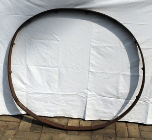 Orbost & District Historical Society
wagon wheel rim, mid 19th century -mid 20th century
Could have been from a hay rake and used on a local farming property.This item is an example of early farming machinery used in the Orb ost district.Rim of an iron wheel. Possibly from agricultural machinery. The 13 spokes have been cut off.iron wheel-rim agricultural-machinery -
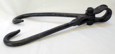 Orbost & District Historical Society
buggy wheel lifter, 1910 -1920
This item was made by John Russell Senior, a blacksmith, wheelwright, farmer and later chairman of the Orbost Butter Factory, makers of Sunny South Butter (today part of Murray Goulburn Co Ltd). The buggy lifter was handed down to George Henry Russell (Doug), the second son between 1970 and 1973.Blacksmiths played an essential part in the regional parts of Victoria and were required to use their ingenuity and skills to design and make tools needed on local farms. This item is an example of a tool specifically designed for a horse-drawn wagon. Horse-drawn wagons are an important part of Australia’s agricultural history. Light buggies were popular with farmers for trips into town before the common use of motorised vehicles.A metal buggy wheel lifter. It has two hooks connected at the top by a bolt and a shackle. The hooks fit under the rim to enable the wheel to be lifted with a pulley / crane system operated by a man or a horse.tool buggy-lifter russell-john blacksmith wheelwright -
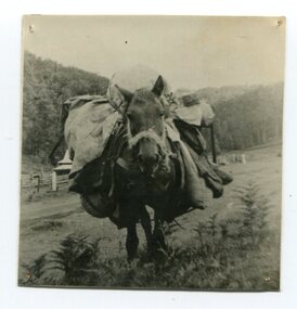 Orbost & District Historical Society
black and white photograph
This is a photograph of "Whalebone", a packhorse belonging to Jimmy Parkes.In the late 1800's early 1900's transporting goods by road was difficult and at times impossible because roads as thoroughfares did not exist.The means of travelling along the roads in the 1800's was by bullock wagon, horse pulled dray, pack horse or simply by foot.A small black / white photograph close-up of a packhorse with a full load. -
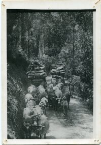 Orbost & District Historical Society
black and white photograph, late 19th - early 20th century
This is a photograph of bullock teams on the Cann Road. out of Cann River, East Gippsland.This is a pictorial record of transport in the mid 18th - early 19th century. Bullock teams could travel in country inaccessible to larger horse - drawn carts or wagon.A black / white photograph of two bullock teams travelling side by side along a bush road.transport-bullocks cann-river -
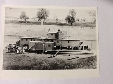 Port of Echuca
Black and white photograph, Earliest 1897
P. S. Marion Dimensions: 107 ft 11 in X 5 ft 3 in Tonnage: 157 tons Built: 1897, at Milang, S. A. References: Book: "Murray River Paddlesteamers" by D. Wardle. pp.22 Riverboats and Rivermen by W. Drake & M. PagePaddlesteamers were a common form of transport along the Murray river in the early 20th century. This photo shows a number of travellers on the boat, judging by their attire, workmen, cook, men in suits and ties as well as a group of people sitting on the bank, possible a woman and children with dog waiting for the boat to depart. There is also a horse drawn wagon with a number of people on and around it that could be waiting to pick up goods (or have unloaded) from the boat. At the back of the boat stacks of wheat bags (?) are visible.Black and white photograph of P. S. Marion moored by a river bank. There is a group of men standing towards the bow and a horse drawn carriage on the bank near the stern. Copy of an original photograph.On the front: MARION on the bow of the boat and on the wheelhouse. On reverse, in pen: Marion. where? Stamped in black: National Library of Australia.riverboats,, paddle steamers, p. s. marion -
Glen Eira Historical Society
Document - BOX FAMILY
Extensively detailed family history from 1838 in UK to present day. Provides much local history and social history into early pioneering and market gardening families. Forty one page computer print out with numerous black and white photographs.box w.h. george, box george, box mary nee cripps, box caroline, box william, box henry, box john, box anna, box eliza, box elizabeth nee avis, box francis, box lydia, moeller a., mclean n., robilliard george james, box ester, box fanny (downard), box eleanor, philbrick richard, fairlam richard, hale jasper, dendy henry, renick mark, renick stefanie (nee riemann), brighton cemetery, ormond, east brighton, prahran, centre road, jasper road, manchester road, mckinnon road, north road, brighton, box cottage, moorabbin historical society, thomas street, elsternwick, paterson road, east bentleigh, tucker road, jasper road, harwood thomas, box violet, hordeen lebbens, augustus arthur, wattle, pioneers, ancient order of foresters, council of moorabin, elster creek, primitive methodist church, lewis’ timber yard, grape growing, paling house, wells, water wagon, market gardens, farming, aboriginal people, king billy, chinese, kayon (?), kay you (yu?), cheong ki, boxer rebellion, chinese missionary, brickmakers, midwife, corben’s monumental masons, sculptor, cottage, parlour, verandah, scullery, le man’s swamp, flower nursery, chook houses, ladies college, moorabbin roads board, western market, eastern market, victoria market, st. kilda road, nepean road/highway, mckinnon, ormond, carnegie, oakleigh, murrumbeena, moorabbin, mordialloc, heathcote, bentleigh, brighton east, manchester road, brighton council, city of moorabbin, west joseph, porter harriet, moore henry, moeller a (moller), box mary, lindsay mccurry elizabeth, lindsay elizabeth, lindsay henry, lindsay frederick, schmidt william, robilliard james cpt., beckett ida, beckett nellie, beckett martha, beckett martha maud, robinson eleanor, robinson joyce, dowling thomas, anderson william snowden, mccurry henry mr & mrs, box emily jane (nee mccurry), jorgensen justin, jorgensen dr., jorgenson bertha, ross william murray, st. kilda, merrie creek, pentridge (now coburg), murray road, wyuna dunoos st, grange road, rosstown, tucker rd, elizabeth st, common school no 213 east brighton, bentleigh, steel roads tracks, rabbits, cheltenham, brighton cemetery, cheltenham cemetery, paterson road, east boundary road, baptist church, lay preachers, missionaries- china, oakleigh tyre works, belfast hotel sandhurst (bendigo), mornington, gas street lighting, brighton historical society, moorabbin primary school, bravis road, lewis street, chalmers street, grange road, butcher shops, ormond state school, oakleigh council, wedding dress, methodist children’s home cheltenham, bentleigh baptist church, auctioneer, lindsay mark, balkham jane, balkham stephen, reitman august william, fitzwilliam catherine, quashdorf (?phonetic) mr, box violet, montford paul, reitman stephanie (renick mrs), reitman william, box ada, downard alicia (lill), downard arthur, downard edward, graham elizabeth, downard octavia rose, downard william alfred, downard arthur henry (harvey), downard fanny, thompson eliza jane, box lena caroline, viloudaki rebecca, box anna (pay), pay henry, box eliza (gurr), johnson geoffrey, rushall eleanor (nellie), gurr eliza nee box, gurr jabez henry tasman, marriot william mrs, ross william murray, box gladys (nee battersby), box dulcie (bussell), bussell samuel robert, bussell norma (hoult), bussell darren lyle, bussell craig andrew, bussell sylvia june (barry), barry j. haydon, barry rachael alexandra, barry phillipa anne, barry vanessa kate, bussell joan lorraine (millie), millie john, bussell harold leslie, euston mr, purdue edgar robert, box lydia elizabeth, wilkinson coral doreen, mitchell donald, centre road, court pride of st george aof, dunoon street, vickery street, darey street/ave., oakleigh state school, methodist church, mill street, koornang road, regent street, marriage road, box olivia christina, box ernest charles, box walter william, lawson robert, lawson nancy eunice (curtis), box walter stanley, box eleanor (nellie) rushall, box martha, box john, box nellie gladys, andrews william (bill), box ray, mccurry mrs elizabeth, box william henry george, schreiber family, jorgensen family, downward arthur, downward alicia – lill, downward octavia rose, downward william alfred, downward arthur henry/harvey, cummings ida, cummings william, downward alice (nee cleary), downward ada, downward lucy (mrs bailey), downward alice, downward arthur harvey, bailey lawrence, bailey ian, bailey carol viola (bartlett), bailey colin harvey, bailey julie alison (hardware), bailey val, bailey adina, bailey david, bartlett brian, bartlett bradley grant, bartlett clayton lawrence, hardware michael, hardware dion michael colin, hardware jevon michael bailey, box elanor, box alice amelia (dale), dale george, dale elizabeth, dale lilly, dale john, dale thomas, dale rose, dale ethelbert, dale george, dale elsie, box thomas henry, box annie lavinia (rogers), rogers annie elizabeth, rogers william richard, box arthur walter, nelson dagma marie (box), box walter kingston, box marie, box cecilia eliza (ainger), ainger james, box ida may, cumming william george, cumming wendy (nee mansell), cumming susan, cumming paul, cumming felicity (steel), cumming shane, cumming melissa, cumming angel, box harold, box dorothy may (jackson), jackson frederick, jackson margaret (walker), jackson judith, walker david, walker michelle (neville), neville andrew, walker darren, walker rebecca (coyne), walker joshua, walker bradley, johnson steven, johnson carl, johnson judith (jackson), johnson peter, johnson melissa (hamid), johnson craig, ely johnson/jackson judith, ely steven, linham arthur, box thelma elizabeth (eagle), eagle keith, eagle nancye elizabeth (harpin), harkin john, harkin mary anne (howe), howe barry, howe samuel, harkin michael, harkin christopher, harkin elizabeth, eagle roddan, eagle carolyn (mansell), eagle gerard, eagle kerri – lee, box avis ann (eldridge), eldridge alf, eldridge robert, eldridge sandra, eldridge adam, eldridge nicholas, eldridge patric, eldridge john, eldridge carol (biggs), eldridge robert james, eldridge catherine elizabeth, eldridge meredith, box william john, box maud (nee hanchette), box malcome, box sandra (ede), box stephen, box nicolle, box andrew, box christine (dormer), box corrina, box jennifer (turpin), turpin phillip, box herbert, box olwyn (richard), box elaine henry, henry bruce, henry james, henry robin, henry david, box richard, box nerida (bowen), box duncan, box john, box cerwiden, box ewan, box bryan, box collen (malony), box kieran, box eden, box christopher, box pam (smith), box sue (tirchett), box thomas, box william, box george frederick, box olive (cameron), box eliza jane (thompson), box francis george, box lena caroline, box-hembrow mable alma, box charles francis, clinch mr., box robinson jessie melinda, box clay edith florence, north brighton, waun alex, waun robert, marquis peter, sheppard w., warnbach mr, marriott william mrs, box dorothy (seabrook), box hazel, box jessie, box frank (francis), seabrook len, box henry, seabrook albert, seabrook stanley allan, barry j. haydon, barry rachel alexandra, millie john, bussell harold leslie, bussell sue, bussell leanne melinda, bussell benjamin leslie, bussell lynette, box george, box jean (holms), box george, box alisa (hughes), hughes justin, hughes ebony, hughes tasman, box robin, box veronica (roman), box andrea roman, box lisa roman, box jodi roman, box malcome, box sue (kerrison), box amanda, box anthony, clay john (jack) francis, clay lynda blanche (nee sibte), clay vivien, clay majory joy, lipman vernon (vern) ronald, clay kenneth graham, clay laura jean -
Glen Eira Historical Society
Photograph - Elsternwick Fire Station, Selwyn Street
A photocopied black and white photograph (96mm x 127mm) of the 1891 Elsternwick Fire Brigade on their way to a fire with a crew of three fire fighters in a one-horse cart racing up a track.elsternwick, fire brigades, fire fighters, elsternwick fire brigade, horse drawn vehicles, carts and wagons -
 Glen Eira Historical Society
Caulfield Transport
Photograph of horse drawn milk float outside Coram’s Hughesdale dairy with “Bluey” the horsecaulfield, hughesdale, milk carts, carts and wagons, coram’s, dairies, bluey, horses -
 Glen Eira Historical Society
Caulfield Transport
Photograph of horse drawn school bus, date unknowncaulfield grammar school, schools, buses, carts and wagons, horses -
 Glen Eira Historical Society
Caulfield Transport
Photograph of the Elsternwick Fire Brigade horse drawn cart, circa 1891elsternwick, fire birgade, carts and wagons, horses -
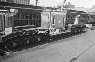 Eltham District Historical Society Inc
Photograph, George Coop, Power transformer on a QB boiler/flat wagon on display at Spencer Street Railway Station during the 1954 Victorian Railways Centenary Exhibition, Sep. 1954
"V.R. Cavalcade" Centenary 1854-1954 Exhibition (11-25 Sep 1954) presented a model railway occupying about 1,400 square feet in the Lower Town Hall featuring a number of model railway working scale models. The exhibition also included a display of rolling stock, track, electrical and other railway equipment held at Spencer Street Railway Station.Digital TIFF file Scan of Kopdak 620 black and white negative transparencygeorge coop collection, display, spencer street railway station, v.r. cavalcade, victorian railways centenary 1854-1954 exhibition, power transformer, qb boiler/flat wagon, qb-13 -
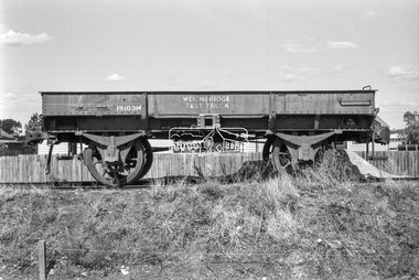 Eltham District Historical Society Inc
Photograph, George Coop, Victorian Railways Weighbridge Test Wagon, Echuca Railway Station, c.1962
Digital TIFF file Scan of 35mm Ilford FP3 black and white negative transparencygeorge coop collection, echuca railway station, weighbridge test wagon -
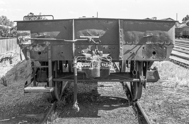 Eltham District Historical Society Inc
Photograph, George Coop, Victorian Railways Weighbridge Test Wagon, Echuca Railway Station, c.1962
Digital TIFF file Scan of 35mm Ilford FP3 black and white negative transparencygeorge coop collection, echuca railway station, weighbridge test wagon -
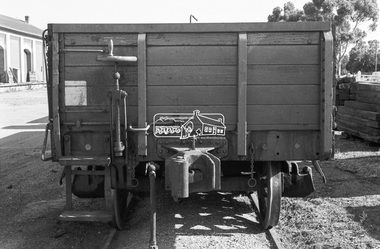 Eltham District Historical Society Inc
Photograph, George Coop, A Victorian Railways QR dropside open wagon at Echuca Railway Station, c.1962
Digital TIFF file Scan of 35mm Ilford FP3 black and white negative transparencygeorge coop collection, echuca railway station, qr drop side open wagon