Showing 9800 items matching " west"
-
 Ringwood and District Historical Society
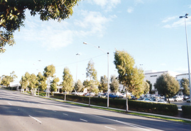
Photograph, Eastland, Ringwood in June 2002, from Warrandyte Road, Ringwood facing west, over the former car park. Showing Safeway (far left) and Myer (right)
Photographic record by Russ Haines, RDHS, in October 2008. -
 Ringwood and District Historical Society
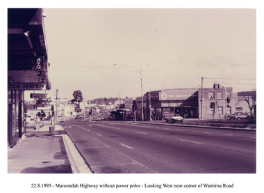
Photograph, Looking west along Maroondah Highway, Ringwood on 22nd August 1993. Wantirna Road intersection, with SEC building and Ringwood Street on right
-
 Ringwood and District Historical Society
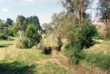
Photograph, Mullum Mullum Creek on 29th Oct 1989, north bank 100m west of Harrison Street, Unknown date
Digital photograph -
 Ringwood and District Historical Society
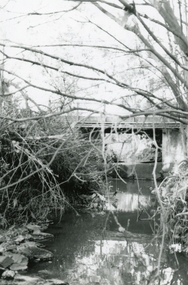
Photograph, Mullum Mullum Creek at the Ringwood Street bridge, west side on 10th September 1989, 1989
Digital photograph -
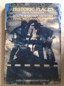 Warrnambool and District Historical Society Inc.
Book, Historic Places of South West Victoria
This is the third in a series of booklets produced by the Land Conservation Council in 1997 (176 pages). Booklets One and Two (1996) contained A Descriptive Report and Proposed Recommendations. The Final Recommendations include information on processes for protection of historic places, lists of significant places in the south-western region and aboriginal historic places. Attached inside the back cover are two maps showing the location of the significant places.This is a useful book as it lists the declared historic sites in the region and researchers will find the information helpful. This is a soft-cover book with a multi-coloured cover featuring a photograph of the Pioneers Memorial, Deep Lead. It has a red-coloured spine and back cover.Front Cover – Historic Places - Special Investigation - South-Western Victoria - Final Recommendations – Land Conservation Council Spine – Historic Places – South-Western Victoria – Final Recommendations – Land Conservation Council Back Cover – Historic Places, Final Rec., code used for retail sales warrnambool -
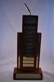 Warrnambool and District Historical Society Inc.
Artefact, Apex trophy South West District, C 1990
This trophy, donated by Camperdown Apex Club, was awarded to members of the South Western District for Dinner Notice Excellence. The winners listed on the trophy are Gerard Ryan, Camperdown, Desi Pekin, Cobden, Dale Alexander, Camperdown, Tim Fitzpatrick, Terang, Leigh Parker, Terang, John Berger, Terang, Kevin Dwyer, Koroit, Maree Fenton, Terang, Grant Picone, Terang and Darren Williamson, Colac. The dates range from 1991 to 2002. Apex Clubs are service clubs that provide people with the opportunity to volunteer within their community. Members are aged between 18 and 45. The first Apex Club was formed in Geelong in 1931 and Warrnambool Apex Club was the fifth club formed in 1931. It went into recess in 1941 and was re-established in 1952. The club closed in 2011. This trophy is retained as it comes from the Apex Clubs of the South West District and Warrnambool Apex Club, now closed, was a member of this group. This is a wooden trophy consisting of a wooden base with a wooden plinth with two wooden columns on either side. The columns have a gold-coloured strip running along the entire length of the columns. On top of the plinth is a gold-coloured holder for a pennant or flag. The base and the plinth have gold-coloured metal name plates. All of these contain inscribed names except one. Donated by Camperdown Apex Club South Western District Dinner Notice Excellence warrnambool apex club, history of warrnambool -
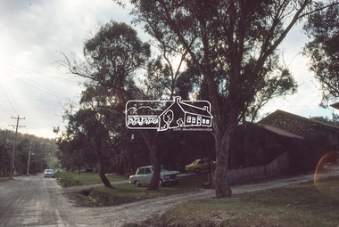
 Eltham District Historical Society Inc
Photograph - Digital Photograph, Jim Connor, View looking west along Luck Street from near Commercial Place,. Eltham, 18 April 2018
Former McEwans the Bunnings builing on right, now Aldijim connor collection, eltham shopping centre, luck street -
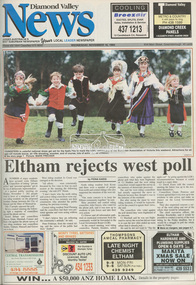 Eltham District Historical Society Inc
Newspaper - Newspaper article, Diamond Valley News, Eltham rejects west poll by Fiona Kaegi, Diamond Valley News, November 16, p1, 1994
council amalgamation, shire of eltham, shire of montsalvat, shire of nillumbik, 1994, city of banyule, city of heidelberg, local government board, montsalvat, shire of diamond valley -
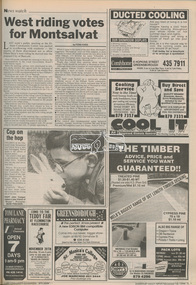 Eltham District Historical Society Inc
Newspaper - Newspaper article, Diamond Valley News, West riding votes for Montsalvat by Fiona Kaegi, Diamond Valley News, November 16, p5, 1994
council amalgamation, shire of eltham, shire of montsalvat, shire of nillumbik, 1994, city of banyule, city of heidelberg, local government board, montsalvat, shire of diamond valley -
 Eltham District Historical Society Inc
Photograph, Frank Stokes with his mother Florence (nee West) and children, Dorothy (left), David (centre) and Beryl (right), Stokes Orchard, Nyora Road, Eltham, c.1950, 1950c
Frank's mother Florence was visiting from England at the time. Frank Stokes first traveled to the district by train in 1944 to find land with the intention to establish an orchard. By chance he met Arthur Bird of Bird Orchard (bounded by Pitt Street, Eucalyptus Road and Wattle Grove) and they got talking over their common interest. Arthur put Frank up for the night and pointed out the land, part of Crown Allotment 15, Section 5, Parish of Nillumbik (CA15) somewhat diagonally opposite Bird Orchard. Frank bought the land and for the next two years would travel by train from Melbourne to Eltham every weekend establishing Stokes Orchard and building a home for his family, which they eventually moved into in 1946. In the mid 1970s the Shire of Eltham divided the orchard up into numerous rate-able parcel lots, which became affordable for Frank. As a consequence Stokes Orchard was turned into a housing development by Macquarie Builders and marketed as the Stokes Orchard Estate in two stages; Stage 1 encompassing Scarlet Ash Court, Ironbark Close and Peppermint Grove bounded by Nyora and Eucalyptus roads c.1976 and Stage 2 encompassing Stokes Place, Orchard Way, The Crest and The Lookout bound by Nyora and Diosma roads c.1979. The development of Orchard Way, The Crest and The Lookout did not proceed as planned due to the lack of the sewer along Diosma Road and so many of the proposed lots were incorporated into five-acre parcels instead.Representative of the orchard growing areas of ElthamDigital file only - Digitised by EDHS from a scrapbook (containing commercially printed photos of digital scans) on loan from Beryl Bradbury (nee Stokes), daughter of Frank Stokes.1950, beryl bradbury (nee stokes), beryl bradbury (nee stokes) collection, david stokes, dorothy stokes, eltham, flatbed truck, florence stokes (nee west), frank stokes, nyora road, stokes orchard -
 Eltham District Historical Society Inc
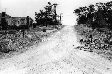
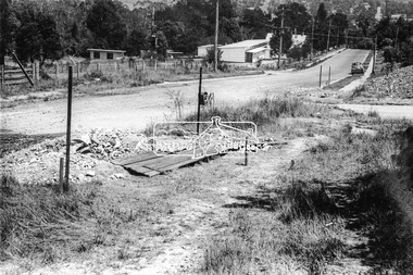
Photograph, Looking west along Bridge Street from intersection with Bible Street, Eltham, c.September 1966, 1966c
Black and white photographic printOriginally located in a Filmpro King Size Prints processing envelope $3.01 Shire of Eltham 9/9/66 and noted as Calrossie Ave area and crossed out Eltham-Yarra Glen Road, Bridge Street to Elsa Court existing conditions mid 1967bible street, bridge street, road construction, streets -
 Eltham District Historical Society Inc
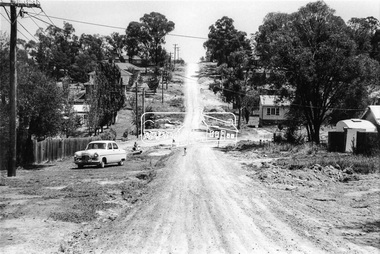
Photograph, Looking west along Bridge Street towards intersection with Bible Street, Eltham, c.September 1966, 1966c
Black and white photographic printOriginally located in a Filmpro King Size Prints processing envelope $3.01 Shire of Eltham 9/9/66 and noted as Calrossie Ave area and crossed out Eltham-Yarra Glen Road, Bridge Street to Elsa Court existing conditions mid 1967bible street, bridge street, road construction, streets -
 Eltham District Historical Society Inc
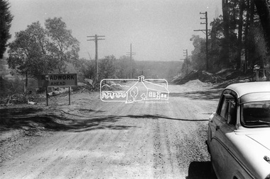
Photograph, Looking west along Brougham Street near No. 101, Eltham, c. September 1966, 1966c
Black and white photographic printOriginally located in a Filmpro King Size Prints processing envelope $3.01 Shire of Eltham 9/9/66 and noted as Calrossie Ave area and crossed out Eltham-Yarra Glen Road, Bridge Street to Elsa Court existing conditions mid 1967brougham steet, road construction, streets -
 Eltham District Historical Society Inc
Photograph, Looking west at intersection of Dalton and Bible streets, Eltham, c. September 1966, 1966c
Black and white photographic printOriginally located in a Filmpro King Size Prints processing envelope $3.01 Shire of Eltham 9/9/66 and noted as Calrossie Ave area and crossed out Eltham-Yarra Glen Road, Bridge Street to Elsa Court existing conditions mid 1967bible street, dalton street, road construction, streets -
 Eltham District Historical Society Inc
Slide, McCarthy Grove, Montmorency looking west near No. 27, c.Oct. 1980
One of a series of images of roads and infrastructure taken by Eltham Shire Council Planning and Engineering officers. They provide perspective of the changes in housing styles and road development that began sweeping in from the mid 1970s with increasing urbanisation of what was once more outlying suburbs and regions.35 mm colour positive transparency Mount - Kodak Kodachrome CardProcessed Oct 1980houses, infrastructure, mccarthy grove, montmorency, roads -
 Eltham District Historical Society Inc
Slide, Quinn Estate from Sackville Street looking west to 'T-bowl' near Main Road, Montmorency, c.Oct. 1980
One of a series of images of roads and infrastructure focussed on the Quinn Estate in Montmorency taken by Eltham Shire Council Planning and Engineering officers. They provide perspective of the changes in housing styles and road development that began sweeping in from the mid 1970s with increasing urbanisation of what was once more outlying suburbs and regions.35 mm colour positive transparency Mount - Kodak Kodachrome CardProcessed Oct 1980roads, housing estate, infrastructure, main road, montmorency, quinn estate, sackville street, t-bowl -
 Eltham District Historical Society Inc
Slide, Quinn Estate looking west along Cressy Street, Montmorency, c.Oct. 1980
One of a series of images of roads and infrastructure focussed on the Quinn Estate in Montmorency taken by Eltham Shire Council Planning and Engineering officers. They provide perspective of the changes in housing styles and road development that began sweeping in from the mid 1970s with increasing urbanisation of what was once more outlying suburbs and regions.35 mm colour positive transparency Mount - Kodak Kodachrome CardProcessed Oct 1980cressy street, housing estate, infrastructure, montmorency, quinn estate, roads -
 Eltham District Historical Society Inc
Slide, Quinn Estate looking west along Cressy Street, Montmorency near no. 29, c.Oct. 1980
One of a series of images of roads and infrastructure focussed on the Quinn Estate in Montmorency taken by Eltham Shire Council Planning and Engineering officers. They provide perspective of the changes in housing styles and road development that began sweeping in from the mid 1970s with increasing urbanisation of what was once more outlying suburbs and regions.35 mm colour positive transparency Mount - Kodak Kodachrome CardProcessed Oct 1980cressy street, housing estate, infrastructure, montmorency, quinn estate, roads -
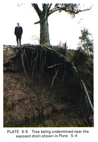 Eltham District Historical Society Inc
Work on paper (Sub-Item) - Photograph, Tree being undermined near an exposed drain on the west bank of Diamond Creek upstream of Bridge Street, Eltham
Colour photograph of tree on the side of the Diamond Creek upstream at Bridge Street, Eltham. The tree has been undermined with roots exposed near a council drain.eltham, diamond creek, bridge street, drainage, roots, tree -
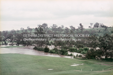 Eltham District Historical Society Inc
Slide, Floodwater, west from Clubhouse of Rosanna Golf Club, Lower Plenty, November 1971, 1971
Many parts of Melbourne flooded including Rosanna Golf Club, Lower Plenty in Novembere 1971. Many surburban roads, including the new south-eastern freeway were cut by flood waters. Here the level of the Plenty River floods onto the golf course. 35 mm colour positive transparency Mount - Agfacolor Service (Blue)floods, lower plenty, rosanna golf club, flooding, plenty river -
 Eltham District Historical Society Inc
Slide, Construction of new bridge, looking downstream from west bank towards existing Lintons Bridge across Arthurs Creek, Doctors Gully Road, Nutfield, 22 February 1972, 1972
35 mm colour positive transparency Mount - Agfacolor Service (Blue)arthurs creek, bridge construction, doctors gully road, eltham shire council, infrastructure, lintons bridge, nutfield -
 Eltham District Historical Society Inc
Slide, On the east side of Bonds Road looking west onto Martin's property, Lower Plenty, 18 July 1972, 1972
Water drainage work undertaken by Eltham Shire Council in Bonds Road, Lower Plenty outside the Martin property opposite Montpelier Drive, July 1972 35 mm colour positive transparency Mount - Agfacolor Service (Blue)Bonds Road (Martin property) 12.10 pm 18.7.72bonds road, drainage works, eltham shire council, infrastructure, lower plenty, martin property, montpelier drive -
 Eltham District Historical Society Inc
Slide, West side of Bonds Road at culvert end wall, Lower Plenty, 18 July 1972, 1972
Water drainage work undertaken by Eltham Shire Council in Bonds Road, Lower Plenty outside the Martin property opposite Montpelier Drive, July 1972 Pitchers in foreground were part of the end wall which was eroded out due to water crossing the road and not going through the culvert. 35 mm colour positive transparency Mount - Agfacolor Service (Blue)Bonds Road (Martin property) 12.10 pm 18.7.72bonds road, drainage works, eltham shire council, infrastructure, lower plenty, martin property, montpelier drive -
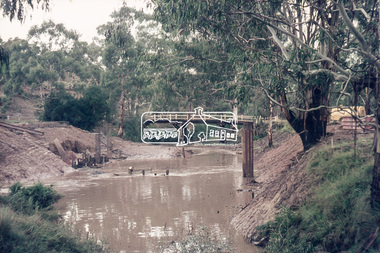
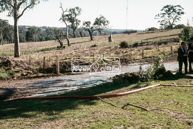
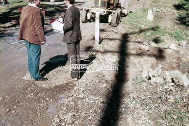
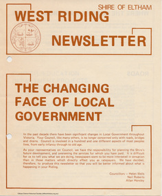 Eltham District Historical Society Inc
Newspaper - Folder, Shire of Eltham, West Riding Newsletter, 1978
Newsletter produced by the Shire of Eltham including introduction titled: "The changing face of local government", signed by Ward councillors: Helen Wells, Neil Roberts and Allan Horsley, a brief financial statement: "where the money comes from", roads, shopping centres, council/education department projects, land purchase, senior citizens and recreation include list of new construction and upgrades. Folder 71 from Harry Gilham Collection4 pages. Foldedallan horsley, community services, shire of eltham, budget, roads, shoppping centres, briar hill, montmorency, recreation, helen wells, neil roberts -
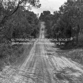
 Eltham District Historical Society Inc
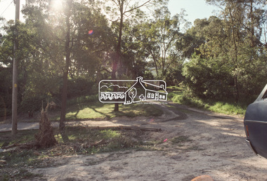
Photograph, Michael Wood, Progress Road looking west from Lower Road, Eltham North, 1976, 1976
Progress Road between Ryans Road and Lower Road, Eltham North; prior to realignment and construction, 1976Kodak Safety Film 120 format 6 x 6 cm black and white negative; 3 strips, 12 frameseltham north, lower road, progress road, road construction -
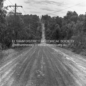
 Eltham District Historical Society Inc
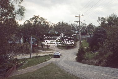
Photograph, Michael Wood, Progress Road looking west towards intersection with Ryans Road, Eltham North, 1976, 1976
Progress Road between Ryans Road and Lower Road, Eltham North; prior to realignment and construction, 1976Kodak Safety Film 120 format 6 x 6 cm black and white negative; 3 strips, 12 frameseltham north, ryans road, progress road, road construction -
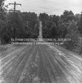
 Eltham District Historical Society Inc
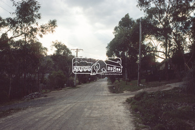
Photograph, Michael Wood, Progress Road looking west towards intersection with Ryans Road, Eltham North, 1976, 1976
Progress Road between Ryans Road and Lower Road, Eltham North; prior to realignment and construction, 1976Kodak Safety Film 120 format 6 x 6 cm black and white negative; 3 strips, 12 frames Also 30 x 25 cm black and white print of this image frameeltham north, progress road, road construction -
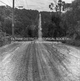
 Eltham District Historical Society Inc
Photograph, Michael Wood, Progress Road looking west towards intersection with Ryans Road, Eltham North, 1976, 1976
Progress Road between Ryans Road and Lower Road, Eltham North; prior to realignment and construction, 1976Kodak Safety Film 120 format 6 x 6 cm black and white negative; 3 strips, 12 frames Also 30 x 25 cm black and white print of this image frameeltham north, progress road, road construction, ryans road -
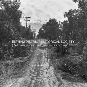 Eltham District Historical Society Inc
Photograph, Michael Wood, Progress Road looking west towards intersection with Ryans Road, Eltham North, 1976, 1976
Progress Road between Ryans Road and Lower Road, Eltham North; prior to realignment and construction, 1976Kodak Safety Film 120 format 6 x 6 cm black and white negative; 3 strips, 12 frames Also 30 x 25 cm black and white print of this image frameeltham north, progress road, road construction, ryans road