Showing 3431 items
matching distance
-
 Lakes Entrance Historical Society
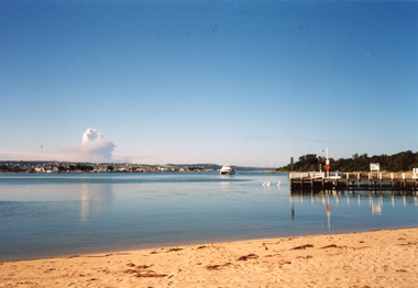
Photograph - Thunderbird, Holding M, 2000c
Colour photograph of the township viewed from the southern shore of Cunninghame Arm at the New Works. New Works Jetty in mid foreground, tourist launch Thunderbird on lake. Smoke from a bushfire in distance. Reflections in calm waters of lake. Lakes Entrance Victoria tourism, waterways, township, boats and boating -
 Lakes Entrance Historical Society
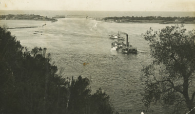
Postcard - Dredge Pioneer, Segerberg and Bulmer, 1910 c
Message on back Arrived safe 25th have a good time hoping you are well from FCG Addressed to Mrs FC Gason, Jessops Hill, Lower NicholsonBlack and white postcard showing dredge Pioneer working below Jemmys Point facing entrance rock groynes on west of Bullock Island calm entrance in distance steamer JCD heading across Reeves Channel after leaving Lakes Entrance VictoriaLakes Entrance waterways, dredges, correspondence -
 Eltham District Historical Society Inc
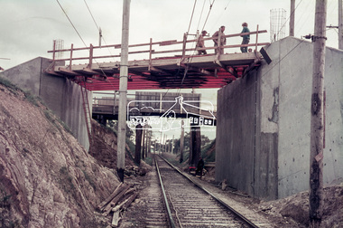
Slide, Sherbourne Road overpass, Briar Hill, Bridge span, c.October 1970, 1970
Construction of new realigned Sherbourne Road railway overpass following realignment construction works for intersection of Sherbourne Road and Para Road. Note old overpass in distance showing how Sherbourne Road was realigned.35 mm colour positive transparency Mount - Agfacolor Service (Blue)briar hill, bridge construction, overpass, para road, railway bridge, road construction, sherbourne road -
 City of Ballarat Libraries
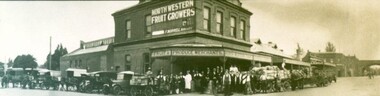
Photograph, North Western Fruit Growers, Ballarat circa 1928
North Western Fruit Growers building, Ballarat c.1920s. This business was operated by F. Morrell, the building was located on the corner of Peel and Sheppard Streets. Peel St railway bridge can be seen in the distance.north western fruit growers, ballarat, f. morrell, commercial, railway bridge, peel street, sherrard street -
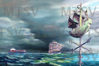 Mission to Seafarers Victoria
Painting, Jack Woods, Heading to a Safe Port, 2017
This painting, which includes the beautifully crafted wind vane above the historic Mission to Seafarers’ building in Flinders Street, Melbourne, symbolises the safe port for the crew of ships, over the years, that have entered Port Phillip Bay, since the Victorian Mission was established in 1857. The stormy ocean weather for the sailors is contrasted with the calm seas near the Mission.This painting was an entry for the 2017 Maritime Art Prize. Jack's marine art covers a wide spectrum of maritime subjects, but with a focus on paintings of classic yachts that ventured over long distances to remote parts of the world. Maritime art, Marine artDonated by Jack WoodsOil painting on linen covered wooden frame, incorporating several features: from left to right a tanker vessel, a windjammer and the galleon wind vane restored to the roof of the Mission in 2020.safe, jack woods, painting, port, artwork, windjammer, windvane, cargo ship, galleon, weather vane, anl, maritime art prize, artwork-paintings -
 Melbourne Tram Museum
Photograph - St Kilda Road with cable trams, c1900
Black and white photograph looking along St Kilda Road with cable trams in the far distance, c1900. Has a cross-over in the foreground. Shows the trees along St Kilda Road, and the various streetlightsDemonstrates a view along St Kilda Road, c1900.Black and white print with adhesive strips on the rear.tramways, trams, st kilda road, cable trams -
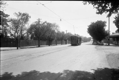
 Melbourne Tram Museum
Photograph - Cable tram track demolition - Nicholson St Fitzroy, 1954/55
Photograph shows cable tram track being removed in Nicholson St to the north of Gertrude St. The cable tram engine house can be seen in the far distance. Photographer and date unknown - 1954/55.Yields information about the removal of cable tram tracks in Nicholson Fitzroy during 1954/55.Black and white photograph with notes on rearOn rear in pencil number "141" in pencil in top right hand corner and "Removing cable track ? St?".tramways, cable trams, nicholson st, trackwork, demolition -
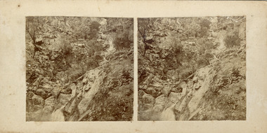 The Beechworth Burke Museum
Photograph - Stereoscopic Photograph, c1900
This photograph depicts Indigo Falls, situated 20 km northeast of Beechworth, and highlights the picturesque scenery and surrounding vegetation. Known for its scenic beauty, Indigo Falls has drawn visitors from Albury and Wodonga and was a popular spot for the Beechworth Tourist Club in the early 1900s.This photograph is historically significant for showcasing the natural beauty of Indigo Falls and surrounding vegetation.Two sepia-toned square photographs featuring a rocky waterfall and vegetation, mounted.Reverse: 97.2197/ Indigo Falls/ Beechworth/ 84-116-1./ A03084/ Indigo Falls are near the start of the Indigo Valley - a short distance from the Indigo Valley Rd. turnoff is Ewarts Rd., on the right of the Beechworth Wodonga Rd., waterfall, indigo falls, ovens district, natural history, stereoscopic, district views -
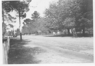 Ballarat Tramway Museum
Photograph - Wendouree Parade - Gardens area, mid 1930s
Black and white photograph of Wendouree Parade looking south. There is an SEC tram in the far distance. A young lad on a bicycle is north bound. Note the fence type on either side of the roadways. Photo possibly mid 1930s.Yields information about Wendouree Parade possibly mid 1930s.Black and white photograph on plain paper.trams, tramways, wendouree parade, botanical gardens -
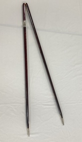 Melbourne Legacy
Ceremonial object, Military Pace Stick
A hinged wooden stick that is used in military situations. It is kept in the Comradeship Lounge as a link to the legatees' military background. A pace stick is a training instrument used to gauge the length of pace and measure distance and interval for military parades. Legacy has a strong link to the military, most early legatees would be familiar with the pace stick and its use.Wooden stick that is hinged, has metal tips and is used as a pace tool.comradeship, pace stick -
 Ballarat Tramway Museum
Negative - Geelong tram at Balliang St loop in Moorabool St, Laurie Gallop, early 1956
Photo shows a Geelong tram to North in Moorabool St at the Balliang St / Forser St loop in Moorabool St. Has the rail over bridge in the far distance. See also item 8298 for the approaching photo.Yields information about the Geelong operations toward the closure of the tram system.Black and white Negative - 120 sizetramways, geelong, belmont, moorabool st -
 Ballarat Tramway Museum
Photograph - Geelong 40 Brougham St, 14-1-1954
The photograph shows Geelong tram No. 40 inbound in Brougham St with the SEC-operated power station and tram depot behind. Another tram can be seen in the distance. Photo by an unknown photographer on 14-1-1954.Yields information Geelong tram services in Brougham St.Black and white photograph with details on rear.In ink "40 on Beach line Geelong 14-1-54" and number '1042" in ink.tramways, trams, geelong, brougham st, tram 40 -
 Melbourne Tram Museum
Photograph - Cable tram - Spring & Nicholson Sts, 1900s
An illustration from a printed publication shows a cable tram in Nicholson St at the intersection with Spring St. In the background is the Grand Hotel, the Princess Theatre. There is another cable tram away in the distance along with a horse drawn cart.Yields information about the intersection of Spring and Nicholson St c1900.Printed illustration from a photograph on paper.tramways, cable trams, spring st, nicholson st -
 Marysville & District Historical Society
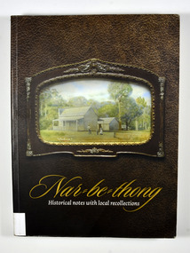
Book, Narbethong-Historical notes with local recollections, 2013
A history of Narbethong taken from recollections of local residentsPaperback. Front cover has a photograph of a painting of 'Lucknow', a farm which was owned by the Yeates Family. Back cover has a black and white photograph of a lady standing next to a wooden sign post showing the Acheron Way and the distances to Marysville, Warburton, Narbethong and Healesville.Stamp of the Marysville & District / Historical Society Inc / P.O. Box 22 / Marysville 3779narbethong, history, victoria, australia, local history -
 Marysville & District Historical Society
Book, Narbethong-Historical notes with local recollections, 2013
A history of Narbethong taken from recollections of local residentsPaperback. Front cover has a photograph of a painting of 'Lucknow', a farm which was owned by the Yeates Family. Back cover has a black and white photograph of a lady standing next to a wooden sign post showing the Acheron Way and the distances to Marysville, Warburton, Narbethong and Healesville.Stamp of the Marysville & District / Historical Society Inc / P.O. Box 22 / Marysville 3779narbethong, history, victoria, australia, local history -
 Hume City Civic Collection
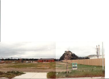
Photograph, early 1990s
The series of 5 photographs feature different views of the Woodlands housing development which opened up land bounded by Gap and Anderson Roads, Cornish Street and Elizabeth Drive in the early 1990s. It was a large housing development built close to Sunbury township.A view of the northern boundary of the Woodlands housing development in Anderson Road. A paling fence divides the estate from the 'Malley' factory, now 'Storage King' which is on the corner of Cornish Street and Anderson Road. A 'For Sale' sign is in the foreground and a partly built house is in the middle distance.housing developments, anderson road, george evans collection -
 Southern Sherbrooke Historical Society Inc.
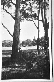
Photograph - Trees and horse at golf course
Photograph of a paddock at the golf course, Lockwood House. Between the trees in the foreground, a horse can be seen grazing in the distance. A wire fence can be seen in front of some trees on the right side. Probably taken by Betty de Coite nee Woods or her parents. -
 Kew Historical Society Inc
Photograph - Regrading the Camberwell Railway Line near Burke Road, E.J. Dower, 1915
One of a series of photographs, taken by Edgar James Dower in the second decade of the twentieth century. Born and raised in Olinda, his family later moved to Surrey Hills. He worked as an adult as a clerk in the city office of the Metropolitan Gas Company, and in his role as a 'collector', he was able to photograph scenes including the construction of tramlines, railways and associated buildings in Kew, Hawthorn, Camberwell and Surrey Hills. Later he established a real estate agency with his brother - the E.J. Dower Real Estate Agency, Dandenong Office.The image is an historically significant record of the development of transport infrastructure which was used to connect Victorians in the first two decades of the twentieth century. This development resulted from increases in population and the consequent extension of Melbourne's suburbs. The photographs, both individually and collectively, richly detail the labour of workers and the tools and machinery used to create and extend Melbourne's public transport network in the years preceding and during World War 1.Digital copy of an original oval mounted photograph depicting workers regrading the Camberwell Railway line following the demolition of the original Camberwell Railway Station. The level crossing gates at Burke Road can be seen in the distance. Named buildings include The Assembly Hall at right.Verso: "1915 / Regrading Camberwell railway line, near Burke Road / Taken by E.J.Dower."theme -- connecting victorians by transport and communications, theme - camberwell railway station, theme - travelling by train -
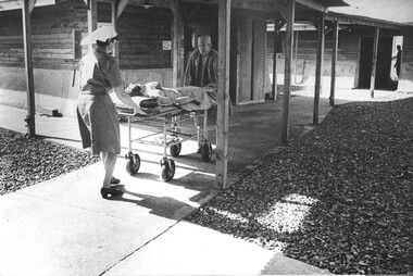 National Vietnam Veterans Museum (NVVM)
Photograph, Gibbons, Denis, Patient Transfer
Denis Gibbons (1937 – 2011) Trained with the Australian Army, before travelling to Vietnam in January 1966, Denis stayed with the 1st Australian Task Force in Nui Dat working as a photographer. For almost five years Gibbons toured with nine Australian infantry battalions, posting compelling war images from within many combat zones before being flown out in late November 1970 after sustaining injuries. The images held within the National Vietnam Veterans Museum make up the Gibbons Collection. A black and white photograph at the 1st Australian Field Hospital, Vung Tau, South Vietnam, Nursing Sister Lt Desley McLean assisted by a Medic wheels a patient from the intensive care ward to the surgical ward, while a digger looks on from the triage in the distance.photograph, 1st australian field hospital, vung tau, lt desley mclean, medic, digger, gibbons collection catalogue, nurse, wounded serviceman, denis gibbons -
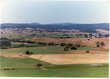 Lakes Entrance Historical Society
Photograph - Mossiface Flats, Tambo Shire, 1994
Also second identical copyColour photograph of the Mossiface Flats, near Bruthen, shows paddocks of the rich river flats, timbered foothills in the distance, with mountain range behind. Some paddocks have been mown for grass hay. Farm buildings in foreground and background. Dam in foreground. Bruthen Victoriaanimals, agriculture, vegetation, topography -
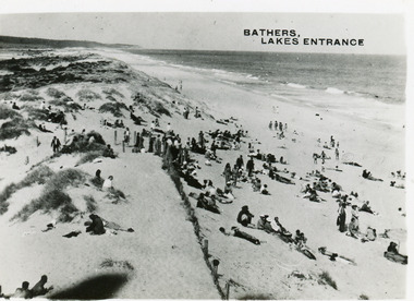 Lakes Entrance Historical Society
Postcard - Ocean Beach, 1950c
2 other copiesBlack and white small format postcard of bathers at the ocean beach. It shows a crowd of people on the sand dunes, remains of a brush fence, Southern Ocean and Red Bluff in distance. Taken from original tower, built for Royal Lifesaving Club. Lakes Entrance VictoriaBathers, Lakes Entrance topography, people, beaches, recreation -
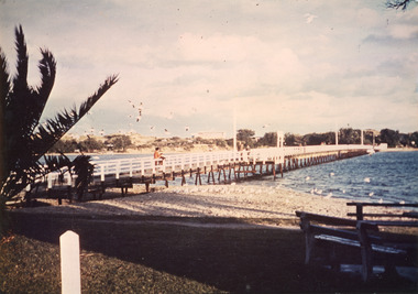 Lakes Entrance Historical Society
Photograph - Footbridge, Tambo Shire, 1985c
Colored photograph of footbridge over the Cunninghame Arm. It shows a flock of seagulls on the northern shore beside the approaches to the bridge, which has white painted railings, surf lifesaving club house on dunes in distance, several groups of people on footbridge. Lakes Entrance Victoriawaterways, bridges, tourism -
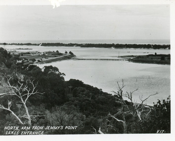 Lakes Entrance Historical Society
Postcard - North Arm, Valentine Series, 1930c
This is the before paired photograph used in the 150 year Lakes Entrance 1858-2008 display.|The after paired photograph number is 01590.1 Also one 12 x 16 framed photograph used in room display.Black and white small format postcard of North Arm and Cunninghame Arm of Gippsland Lakes, taken from Jemmys Point, Club Hotel at western end of town, bridge to Bullock Island, scrub covered hummocks and Bass Strait in distance. Lakes Entrance VictoriaNorth Arm from Jemmys Point Lakes Entrancebridges, islands, waterways, topography -
 Bendigo Historical Society Inc.
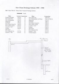
Document - DRAINAGE PROBLEMS - DRAINAGE 1905 - 1908
Two handwritten pages naming the mine, the lowest connection and connection to the next mine for the proposed drainage scheme. The second page lists the mines, from South to North, the projected distances in feet and to the nearest yard. Document from Albert Richardson Collection of mining history.document, gold, drainage problems, new chum drainage scheme, drainage 1905 - 1908, mines dept sheet 796/a/6 proposed drainage scheme, south belle vue, eureka ext'd, new chum railway, new shenandoah, shamrock, garibaldi, new chum consol'd, new chum united, lansell's 222, lazarus, old chum ?, new chum & vic, lansell's 180, victoria quartz -
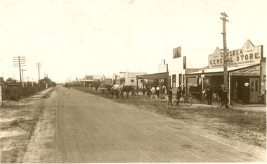 Chelsea & District Historical Society Inc
Photograph - Point Nepean Road, Chelsea
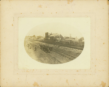
Black and white photo of Chelsea, showing Point Nepean Road, the railway line, people, shops, horse and cart and bicycles. Chelsea Railway Station can be seen in the distance. Shops that can be identifies are the Chelsea General Store, J & C Caudwell and Timber Merchant.chelsea, point nepean road, nepean highway, railway -
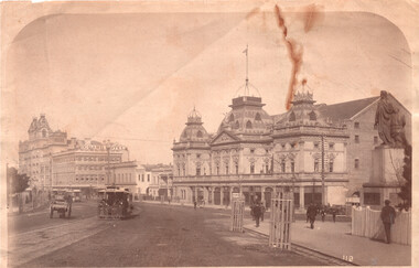
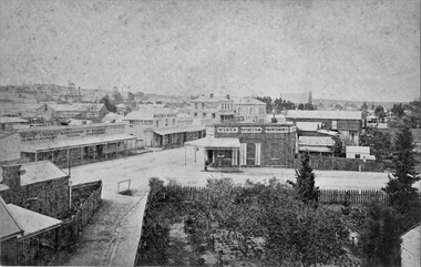 Stawell Historical Society Inc
Photograph, Patrick Street and the Corner of Sloane Street with Stawell Court House in the background & St Patricks Church on the Horizon 1878
Patrick Street Sloane Street intersection in the 1880’s (Herbert Photo) On Big Hill side of Patrick Street is Matthew Cairns Plumber & Gasfitter, R. Greenwood Tailor, Mrs. Goodwin Cafe & Restaurant, Mack's Hotel, Grocer, Boot and Shoemaker, J. Farleys Auction Room, J.B. Wallis Royal Exchange Hotel, Stawell Court House and St Patricks Church in Distance On corner of Patrick and Sloane Streets, Melbourne Cash Store Wine Spirits & Provisions. In background mining poppet head behind livery stable. St Patrick Church in distance on right. 1878Patrick St, Sloane St intersection looking south . The Stawell Library now occupies this corner.Victorian Views. C. Herbert, Photo. Stawell 1878stawell business streetscape -
 Melbourne Tram Museum
Photograph - L class 102 in revenue service Swanston Street, 1960s
Photograph of L class tram 102 on Swanston Street in revenue service to East Brighton route 64. The photograph looks northward over Lonsdale Street with a W class tram in the distance along with several motor vehicles. A passenger safety zone with flashing lights is in clear view along with Christmas decorations hanging from the span wires. During the 1960s, L class trams were brought back into revenue service because of a shortage of rollingstock. Because the W class tram in the distance does not appear to be fitted with side lights, this suggests the photograph is from the 1960s. Yields information about shortage of rollingstock and L class trams in 1960s. Black and white photograph with nothing on rearside lights, l class, tram 102, swanston street, east brighton, rout 64, safety zone, rollingstock shortage, w class -
 Port Melbourne Historical & Preservation Society
Photograph - Elevated view to Gasometers & Albert Park High School, Reverend Donald LANGFORD, June 1973
Taken from a vantage point- possibly Holy Trinity Manse -the typical 197'0's Port Melbourne roof lines are the foreground with the still erected gasometers and original Albert Park High School can be seen in the distance.B & W photograph taken before the gasometers were removed & Albert Park High School rebuilt as Albert Park College.June 1973built environment - demolition, built environment - industrial, education - secondary schools, gasometer -
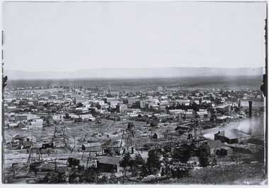 Stawell Historical Society Inc
Photograph, View of Stawell from Big Hill April 1874 showing mines centered on north end of Main Street -- 2 Photos
From left Shire Hall Pleasant Creek in distance, Mathers & Franklin, Stawell Coach Factory, Coffee Palace, Christ Church of England Church Hill, Mechanics Institute, Temperance Hotel, Matherson Cross Reef Hotel.Black and White Holtermann photograph of Stawell from Big Hill with mining in foreground. 1874 Site of fire in Main and Street Patrick Street 22 April 1874 visible in centre of photograph.mining, panorama, streetscape -
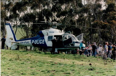 Sunbury Family History and Heritage Society Inc.
Photograph, Police Helicopter, c Early 1990s
After the police spoke to the students from Bulla Primary School and they had all had a chance to look over the rescue helicopter, the children were taken a safe distance away from the craft and watched it take off.A non-digital coloured photograph of a group of children lined up and looking at a police helicopter in a paddock. There are a number of tall gum trees in the background. police helicopters, policemen, bulla primary schooil