Showing 5282 items
matching flood-marker-orbost
-
 Charlton Golden Grains Museum Inc
Photograph, Barber, Mr, c. 1933
1933 Flood, in Armstrong Street, Mr Barber and dog in boat.1933 flood in Armstrong Street. Mr Barber and dog in boat.flood, charlton -
 Orbost & District Historical Society
plaque
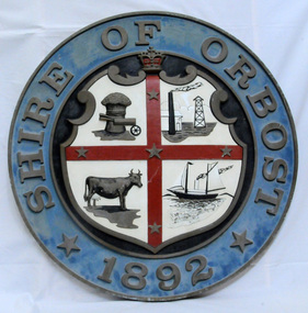
The Coat of Arms of the Shire of Orbost has been designed in the form of a cross in which five stars are set on a shield. This was typical of those used by many shires and cities throughout Victoria and the Commonwealth. A small crown above the cross indicates the loyalty of the President, Councillors and Ratepayers to the reigning King or Queen. The inner circle of the shield contains four figures, a sheaf of wheat, a factory, a cow, and a ship, which represents the activities of agriculture, fishing, industry and dairying undertaken in the district. Originally part of the Bairnsdale district, Orbost split away as part of the Shire of Tambo in 1882, and became a Shire in its own right as the Shire of Croajingolong on the 30th may 1892. The name changed to the Shire of Orbost on 17 February 1893. Orbost was divided into four ridings on 31st May 1895, they were the North, South, East and Central riding, which was represented by three elected councillors. The Shire coat of arms was on the wall on the right of the front entrance to the building and was removed from the current building when Orbost Shire Council was amalgamated into East Gippsland Shire in 1994.The current building was opened on Friday 28th February 1969 by the Premier of Victoria, The Hon. Sir Henry E. Bolte, K.C.M.G., M.P. Local governments play an important role in the lives of citizens in Australia. Local government authorities exist to provide services and amenities to local communities, and are also responsible for regulating and providing services for land and property in their district. This item is representative of a time when Orbost had its own Shire Council. A large round metal plaque with the words SHIRE OF ORBOST1892 in gold letters around a crown and shield divided into four sections to represent four industries : Shipping ; farming - maize ; dairy and mining.SHIRE OF ORBOST 1892government orbost-shire-council coat-of-arms plaque -
 Orbost & District Historical Society
stamp
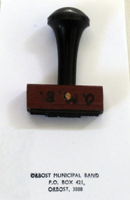
The first Orbost Brass Band was formed in 1889. Around 1908 the town band split and the Orbost Workers' Band was formed. Eventually the two bands merged in 1913 to reform as the Orbost Municipal Band under conductorship of Charles Spink. The Orbost Municipal Band continued on for many years but was disbanded and reformed many times. The last time it was reformed was in 1961. Today it no longer exists. Further info and Ref: In Times Gone By - Deborah HallThe various Orbost bands over the years played a major role in community activities providing entertainment and musical experiences for the many members.A rectangular shaped rubber stamp with a wooden handle. The stamp was used by the Orbost Municipal Band.O.M.B. in black on frontorbost-municipal-band seal stamp -
 Orbost & District Historical Society
black and white photographs, 1920s - 1930s
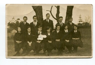
These photographs are os students and staff of the Orbost Higher Elementary School. In photograph 3161.1 are; Back- F. Boucher; ? Bundle; Les Nielsen; Arnold;Keith Perry Front - Pen (Gilbert?); Elsie Pardew; Connie Tomlinson; Marion ? In 3161.3 are: Keith Nixon; Frank Perry; Lance Bridle; Arnold Ahern; Frank Boucher; F. ?; M. Nixon; Les Nielsen; Elsie Pardew; Myra Malcolm.Orbost High School / Orbost Secondary College has played a significant part in the education of senior students in the Orbost district . It is the sole senior educational institution. These photographs are representative of its history.Four black / white photographs associated with Orbost Elementary High School. 3161.1 is of two rows of school students in school uniform. Boys are in the back row standing and girls are seated in the front row. 3161.2 is a smaller photograph of two rows of girls in school uniforms. - four in the back row and three in the front. Both rows appear to be standing. 3161.3 is of students and teachers. The back row is standing and the front sitting. 3161.4 is of a row of girls in sports uniforms , each holding a hockey stick. They appear to be posed in front of goal posts. This is a smaller photograph.3161.1 - on back is a list of names. 3161.3 - on back is 1921 and a list of names 3161.4 on back is "Anne Richardson" and a hand-written Christmas shopping list -
 Orbost & District Historical Society
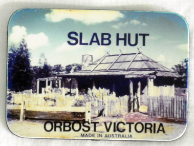
souvenir, C 1980's
Used as a tourist souvenir of Orbost. Possibly made and distributed via the Slab Hut (Orbost Visitor Information Centre) in 1980's/1990's.The souvenir is an important component of the tourist experience with most tourists bringing back mementos and souvenirs as evidence. Fridge magnets are popular as souvenir and promotional items because they are relatively cheap to manufacture and very portable for tourists. This item is an example of a typical souvenir of Orbost. A small flat rectangular fridge magnet with a colour photograph of the Slab Hut (Orbost Visitor Information Centre) on one side. The other side is grey/black, At the top of the coloured side is "SLAB HUT" and below is "ORBOST VICTORIA made in Australia".souvenir-orbost fridge-magnet -
 Orbost & District Historical Society
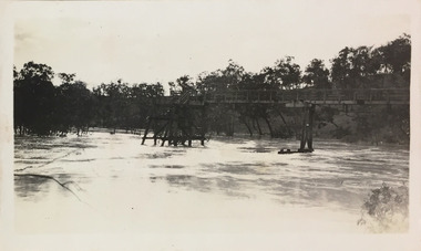
black and white photograph, Howard D. Bulmer, first half 20th century
A new bridge over the Snowy River at Orbost was opened for traffic on June 20th 1922. It was intended as a road and rail bridge, and was again partly washed away by flood waters in 1934. After the end of the first World War the Victorian Railways considered an extension of the railhead across the river at Orbost, and in 1922 a new timber and steel girder structure, a joint Country Roads Board — Victorian Railways venture, was built and completed at a cost of £41,000 (the steel girders came from the Flinders Street viaduct reconstruction). Subsequently it was decided decided not to take the railway across the river, and the bridge was only used by road traffic. This is a pictorial record of an early bridge over the Snowy River at Orbost.A black / white postcard photograph of a bridge across a shallow river with men on horseback underneath.snowy-river-bridge -
 Orbost & District Historical Society
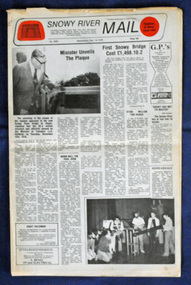
newspaper, Snowy River Mail, 1.12.1976
In early 1974, as an Engineer with the Country Roads Board, David came to Orbost as the Supervising Engineer for the construction of the new bridges which were part of an 8.4km Orbost bypass road design. This was a major project involving not only a new bridge over the Snowy River (including Lochiel Lagoon), but other bridges over Ashby’s Gulch and Watt’s Gulch. These new bridges were opened in November 1976 with the unveiling of a plaque on the eastern end of the $2.4M Snowy River Bridge. The new bridge, built by the CRB at a cost of $2.4 million, is 1.6 metres above the record flood levels of 1971. (ref. May Leatch) This newspaper contains contemporary reports of a significant event in Orbost.A Snowy River Mail newspaper, dated 1.12.1976. It contains news articles, photographs and advertisements. The main article relates to the official opening of the Snowy River Bridge and the unveiling of a plaque on the eastern approach. It also contains a history of the first Snowy River Bridge.snowy-river-bridge orbost-bridges snowy-river-mail -
 Orbost & District Historical Society
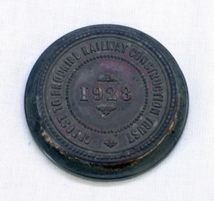
seal, 1928
On 23 December an act was passed to authorise the construction by the State (Victoria) of a line of railway from Orbost to Brodribb. Even as late as 1913 the railway was still expected to go through Orbost and beyond. In the Orbost area a committee was formed called the Bairnsdale to Orbost Railway Trust. The business of the trust was to acquire the land necessary for the railway and levy a rate on the property owners. The other cost to the area wanting a railway was the guarantee against loss in working expenses of the railway, the Orbost Shire had to provide up to £3000 per annum. The line was never constructed and the Bairnsdale to Orbost Railway terminated on the western side of the Snowy River. This item is associated with the history of the Orbost-Bairnsdale railway line and therefore reflects the role that the rail line played in the social and economic history of Orbost.A round copper disc with a metal seal on top. "Orbost to Brodribb Railway Construction Trust - 1928"seal railway orbost-bairnsdale-railway -
 Kew Historical Society Inc
Photograph - Flood, Zig-Zag, Kew, 1924
Henry Beater Christian (1886-1962) , was a descendant of one of the earliest settler families in Kew. Employed at the Kew Asylum as a 'public servant', he was a skilled amateur photographer, photographing numerous scenes in Kew and on his travels around Victoria. The majority of his photographs date from 1916 to 1929. His finest photographs are housed in two photograph albums. Digital copy of a photograph from page 5 of the 47-page photograph album containing 261 gelatinous silver images, loaned by Diane Washfold with permission given to digitise and hold a copy in our collection. This is a photograph of the river at Kew during a flood in January 1924. A section of the Zig-Zag Bridge can be seen in the distance. "Flood / Zig-Zag Kew / 1.24"henry beater christian (1886-1962), landscape photography, kew (vic.) — yarra river, christian-washfold collection, photograph albums, floods -- yarra river -- kew (vic.), zig-zag bridge -
 Orbost & District Historical Society
black and white photographs, Brown , G, first half 20th century
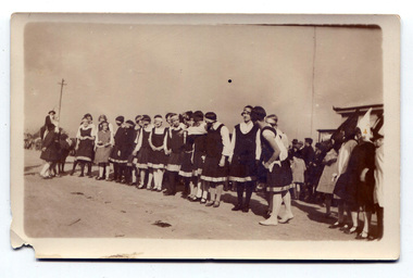
This photograph is probably of school teams.This is a pictorial record reflecting the importance of sport in Orbost society.Two black / white photograph / postcards of a group of girls dressed in sports uniforms. In photograph 3155.2 a man is holding a drum stick and another a drum. There are two other men on the left. All men are wearing suits.3155.2 - on back - "Girls Hockey Team Orbost V Newmerella Newmerella won"sport-hockey-orbost recreation -
 Kew Historical Society Inc
Photograph - Flooded street, 1940-50
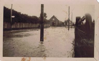
View of unknown flooded streetscape.Original, black and white positive of a flooded street, originally believed to have been in Kew, but based on an examination of the history, deemed not to be a location in Kew or Kew East. The flooding is of a T-intersection with a brick church and a house in the background.Inscribed verso: "? Kew / R 774 / VELOX"floods -
 Lakes Entrance Historical Society
Photograph, 1920 c
Also a black and white photograph of a baby in a pumpkin bed 05109.1 10 x 15 cmBlack and white photograph of five children Cora Lynn, Enid Easton, Jim Jean and Ivan Trewin in a hollowed out pumpkin boat at Orbost Victoriawaterways -
 Orbost & District Historical Society
clock, mid-late 19th century
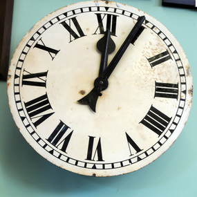
The new Post and ·Telegraph Office at Orbost was completed in 1898 This clock was presented by Mr A Cooper to the Postal Dept.in 1899 for erection outside the local post office. The clock arrived in Orbost on Monday 5th June 1899 in the charge of Captain Mortimer of the schooner Orbost. Before the clock could be placed in position permission had to be obtained from the postal department headquarters, and Mr Cooper nominated the appointment of Messrs W. Gluth Snr, J. Watt and H. James as a committee to take charge of the clock on behalf of the people of Orbost. In a letter to Mr Gluth at that time, Mr Cooper said, " If the people of Orbost receive this clock in the same goodwill in which it is given I shall be exceedingly pleased." Mr Alfred Cooper built the Orbost Club Hotel in the early 1890's. Captain Mortimer skippered the Schooner Orbost between Marlo and Melbourne until it was wrecked in 1904This clock is a significant part of Orbost's history.A metal clock from the Orbost Post Office. It is circular with black Roman numerals. It is open with no cover.orbost-post-office cooper-alfred schooner-orbost clock-orbost-post-office -
 Orbost & District Historical Society
rate books, 1977 - 1984
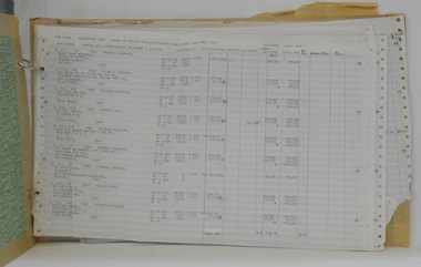
These items were donated to Orbost & District Historical society from P.R.O.V. as a Place of Deposit (POD) item for safe keeping by a local history group or museum. The shire covered an area of 9,347 square kilometres and existed from 1892 until 1994 when it became part of the East Gippsland Shire Council. The East Gippsland Region Water Authority was constituted on January 1, 1995. The new Authority assumed responsibility for the services previously provided by the Mitchell Water Board, the Tambo Water Board, the Orbost Water Board and the Mallacoota Water Board. East Gippsland Water is the registered business name of the East Gippsland Region Water Authority. (info. from P.R.O.) These items are a historical record of Orbost Shire transactions with water management authorities which no longer exist.Seven rate books for the Shire of Orbost, Mallacoota and Cann River Water Trust. 2554.1 with records from 1977-1978 has a brown cardboard cover and string binding. 2554.2 has a brown cardboard cover with a hand-written title and green string binding. Records are from 1978 -1979. 2554.3 has a brown cardboard cover with a hand-written title and green string binding. Records are from 1919 - 1980. 2554.4 has a white cardboard cover and taped spine. In black print on the cover is 1980/1981. 2554.5 has a green cover with a metal fastening clip. Records are from 1980 -1981. 2554.6 has a white cover, taped binding and metal clips.Records are from 1982 -1983. 2554.7 has a white cover and metal rings. It is dated 1984.water-rates cann-valley-water-board -
 Orbost & District Historical Society
book, Nature Fantasy in Australia, 1932
The book was used in the Orbost High School library. A blue covered book covered in plastic, Inside the front cover is a library card with a stamped date - 27 February 61 - 2 March 1983. On the back cover is a bar code. written by Alec H. Chisholm. Published by J M Dent & Sons.Stamped throughout is High School Orbostnature-fantasy-in-australia chisholm-alec-h, birds -
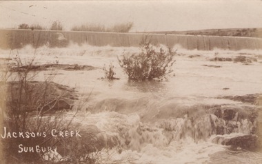 Sunbury Family History and Heritage Society Inc.
Photograph
The river in flood is the Jacksons Creek. This section of the river with the waterfall is downstream from the town of Sunbury.A sepia photograph in post card format of a river with waterfalls in flood.rivers, jacksons creek, sunbury -
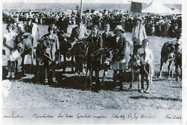 Orbost & District Historical Society
Photograph - Children and their calves at Orbost Show c. 1930
This a copy of an original photo supplied by Lachlan Macalister in 2013. The photo is evidence of local children from farms in the Orbost district attending an Orbost Show. The calves are dairy calves and all of the handlers are children. Orbost is a farming area with dairying and cropping. An early photo of children at the Orbost Show.This b/w photo is of a group of children and their calves at the Orbost Show. In the background is a large crowd of people and a tent. Written onto the photo and below the photo are these words: Aenis Leatham, Marie Colson, Penel Yantses, Sylvia Field, George Leatham, Cathie Kelly, Ruby Joy, Walter Webb, Joe Webborbost agricultural show, dairying, children at the show -
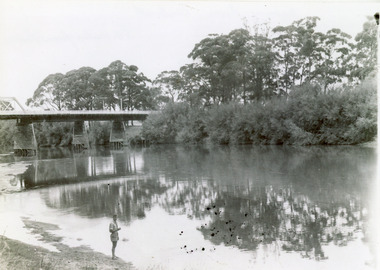 Lakes Entrance Historical Society
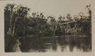
Photograph - Bridges, 1947
Date made February 1947Black and white photograph showing part of the road bridge over there Snowy River, river level low, man in shorts standing at edge of river. Orbost, Victoria.bridges, waterways, recreation -
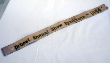 Orbost & District Historical Society
ribbon, 1944
This ribbon was won at the Orbost Annual Show Gymkhana in 1944 by Ron Cameron on a horse called Gene. The first meeting to form an Agricultural society in Orbost was convened by the then Orbost Progress Association and held in the Mechanics Hall on Saturday, 10th October 1891. Its first show was held on 3rd March 1904...on a site alongside the Bonang Road where the present Golf Club stands. It is currently held at the Recreation Reserve at Newmerella. Ref: In Times Gone By-Deborah HallThis item is associated with the Orbost Agricultural Society 's Annual Show which has been a major event in Orbost for over a century. Agricultural shows are an important part of cultural life in small country towns and the Orbost Show is an integral part of Orbost 's agricultural history.A white felt ribbon with gold writing - "Orbost Annual Show Gyhkhana-1944"ribbon equestrian cameron-ron orbost-show gymkhana -
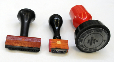 Orbost & District Historical Society
stamps, 1990's
The Orbost Aero Club Club played a significant role in the establishment of the small airport at Marlo and in the ongoing operation and development of the airport over the years.Three stamps used by the Orbost Aero Club. 2406.13 has a red plastic handle with a circular base. 2406.14 has a black plastic handle with a narrow rectangular base. 2406.15 has a black wooden handle with a small rectangular base. 2406.13 : In centre circle THE COMMON SEAL OF In outside circle ORBOST AERO CLUB INC ACN 004 832 991 on top of handle ESCO 2406.14 On stamp - Orbost Aero Club 2406.15 On stamp Orbost -
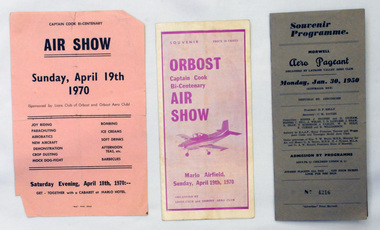 Orbost & District Historical Society
souvenir programs, 1950 ; 1970
Orbost Aero Club began in 1969 with Basil Dowie as Chair, David Nixon as Secretary/Treasurer. The group went into recess from 1977-1991 closing in 1997. The mid 1960s were boom years in flying training in Australia and the number of Aero Clubs grew rapidly. The Club played a significant role in the establishment of the small airport at Marlo and in the ongoing operation and development of the airport over the years particularly for patient transfer by aerial ambulance. The Orbost Aero Club Club played a significant role in the establishment of the small airport at Marlo and in the ongoing operation and development of the airport over the years.Two souvenir programs and one advertising flyer. 2406.27 is a souvenir program for the Orbost Captain Cook Bi-Centenary Air Show 1970. It is purple print on a white background. It has seven folded glossy pages and cost 20c. On the cover is a photograph of a small plane. 2406.28 is a flyer for the Captain Cook Bi-Centenary Air Show, Sunday, April 19th 1970. It is black print on a pink background, 2406.29 is a souvenir program for Morwell Aero Pageant, Monday, January 30, 1950. Cost 3/-. No 4216. It is a grey/brown coloured card folder with black print.2406.28 - on back - Bruce Ham......(?) Yarram Tiger Moth orbost-aero-club captain-cook-bicentenary -
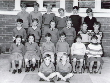 Lakes Entrance Historical Society
Photograph - Orbost State School, 1968
Black and white photograph of ten sets of twins surnamesHolding, Dent, Flight, Morgan, Reeves, Austin, Waddell, Young, Orton, Trist. attending State School Orbost Victoriaeducation, schools, students -
 Kew Historical Society Inc
Photograph - Flood, Zig-Zag, Kew, 1924
Henry Beater Christian (1886-1962) , was a descendant of one of the earliest settler families in Kew. Employed at the Kew Asylum as a 'public servant', he was a skilled amateur photographer, photographing numerous scenes in Kew and on his travels around Victoria. The majority of his photographs date from 1916 to 1929. His finest photographs are housed in two photograph albums. Digital copy of a photograph from page 5 of the 47-page photograph album containing 261 gelatinous silver images, loaned by Diane Washfold with permission given to digitise and hold a copy in our collection. This is a photograph of the Zig-Zag Bridge that crossed the river at Kew during a flood in January 1924. The contrast in the photo is compromised because of the weather conditions and due to shooting into the light."Flood / Zig-Zag Kew / 1.24"henry beater christian (1886-1962), landscape photography, kew (vic.) — yarra river, christian-washfold collection, photograph albums, floods -- yarra river -- kew (vic.), zig-zag bridge -
 Kew Historical Society Inc
Photograph - Flood, Zig-Zag, Kew, 1924
Henry Beater Christian (1886-1962) , was a descendant of one of the earliest settler families in Kew. Employed at the Kew Asylum as a 'public servant', he was a skilled amateur photographer, photographing numerous scenes in Kew and on his travels around Victoria. The majority of his photographs date from 1916 to 1929. His finest photographs are housed in two photograph albums. Digital copy of a photograph from page 5 of the 47-page photograph album containing 261 gelatinous silver images, loaned by Diane Washfold with permission given to digitise and hold a copy in our collection. This is a photograph of the river at Kew during a flood in January 1924. The bridge is the Zig-Zag Bridge that linked the Yarra Bend and Kew Asylums (built 1870s-demolished 1929)."Flood / Zig-Zag Kew / 1.24"henry beater christian (1886-1962), landscape photography, kew (vic.) — yarra river, christian-washfold collection, photograph albums, floods -- yarra river -- kew (vic.), zig-zag bridge -
 Orbost & District Historical Society
black and white photographs, 25.11.1976
These photographs were taken on November 25, 1976 at the official opening of the current Snowy River road bridge. Included in the photographs are: John Duggan; Pat Hall, C.R.B. chairman, R.E.V. Donaldson (3240.7) and J.A.Rafferty, the state minister for Transport, who cut the ribbon (3240.8). Di Young and Cheryl Dusting (3240.9) distributed souvenir information pamphlets to official guests. The Snowy River road bridge is one of four built as part of the 8.4 km project spanning the Orbost flood plains. The Snowy River bridge and another over the nearby Ashbys Gulch are among the 10 longest bridges in Victoria, being the eighth and fifth longest respectively. The new bridge removed through traffic from Orbost township crossing the Snowy River 45 m downstream of the old bridge.This bridge is the fourth to provide a crossing to the township of Orbost. (info from CRB NEWS No. 34. DECEMBER, 1976) These photographs are pictorial records of a significant event in Orbost's history.Eleven black / white photographs all related to the official opening of the current Snowy River Bridge. Details are in catalogue folder.snowy-river-bridge -
 Kew Historical Society Inc
Photograph - Flooding of shared path at rear of Guide Dogs Victoria, 1993
The land currently occupied by Guide Dogs Victoria was once part of the grounds of the Kew Lunatic Asylum. This includes the land, designated as parkland which adjoins the Yarra River. Original colour small format polaroid photograph of flooding in parkland at the rear of Guide Dogs Victoria in the area now used as the Main Yarra Trail; taken on 16 September 1993."Flooding of shared path on 16.9.93 / Rains 15.9.93 - rear Guide Dogs [Victoria] land"yarra river -- floods -- kew (vic.), guide dogs victoria, main yarra trail, chandler park -
 Kiewa Valley Historical Society
Photos - x2 Damms Road River Crossing
Damms Road river crossing after the c1993 floods of the Kiewa River. The old bridge was inundated, later to be washed away.The Kiewa River flooded in 1993 at Damms Road when the old bridge was washed away.2 coloured photos of the Kiewa River in flood at Damms Roadkiewa river flooding, bridge at damms road -
 Orbost & District Historical Society
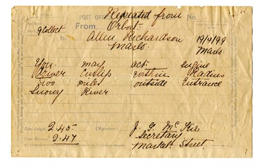
telegram, April 1899
This message concerned the P.S. Curlip's entry to the Snowy River Lakes Entrance. It was logged at 2:45 and received at 2:47.This item is associated with the P.S. Curlip and the Richardson family, early Orbost pioneers.A white paper telegram with blue print and details hand-written in black ink. It has been sent fro Orbost to "Allen Richardson Marlo". The handwritten message is difficult to decipher."You may enter - engine driver Curlip within two miles outside Entrance Snowy River."telegram-richardson-curlip communications-19th-century -
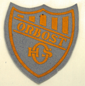 Orbost & District Historical Society
badge
This felt badge formed part of the Orbost High School's boys' sports uniform. It was sewn onto the inter-school sports uniform.Orbost High School / Orbost Secondary College has played a significant part in the education of senior students in the Orbost district . It is the sole senior educational institution. This badge is representative of its history.A felt shield-shaped badge which is grey with ORBOST in yellow print.education orbost-high-school uniform badge -
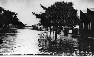
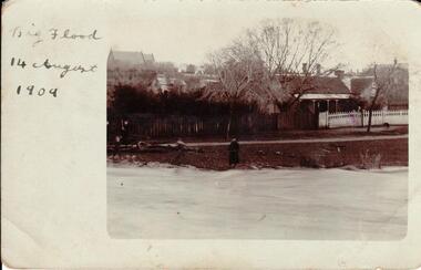 Hume City Civic Collection
Photograph, 14/08/1909
The Jackson Creek flooded on 14 August 1909 when the creek was 32 feet above sea level.A sepia photograph of Powlett Street in the big flood of 1909. Unmounted postcardjackson's creek, powlett street, sunbury, floods, gregor, bob, billinghurst, beryl, francey, sandra, alex, our lady of mt carmel church, churches, 1909, george evans collection