Showing 9372 items matching "hobsons-bay"
-
 Stawell Historical Society Inc
Book, Michael Menzies, Rails To Lubeck, Rupanyup, Marnoo, Wallaloo, Bolangum, Warranooke, Navarre, 2014
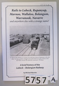
White Paper cover with inset border containing Title & B/W Photograph of a rail yard with flat cars and wheat bags, buildings in the distance. Rails to Lubeck, Rupunyup, Marnoo, Wallaloo, Bolangum, Warranook, Navarre and anywhere else with a strange name! Ex Hobson's bay Railway Co. N Class 252 on the down mixed at Rupunyup in the early 1900's. The large quantities of bagged and stacked wheat were quite common in the days before concrete silos dotted the countryside (VR photo) A Brief history of the Lubeck - Bolgangum Railway By Michael Menziesstawell transport railways -
 Phillip Island and District Historical Society Inc.
Photograph, Anderson Family & Homestead
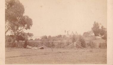
Glen Isla built in 1868 by Robert Anderson, additions 1987 - 88. Had several owners subsequently, bought again into family by Grandson Stan Anderson but sold when he died. Now owned and restored by Mr & Mrs Lunn.Distant view of Glen Isla House depicting rural setting and Western Port Bay glimpse in background.local history, photography, photographs, slides, film, glen isla house, phillip island, sepia photograph, mrs emma anderson jacobs -
 Glenelg Shire Council Cultural Collection
Decorative object - Commemorative Place - Naming of Portland Bay, n.d
Commemorative plate, manufactured by Adams. 'Lieutenant Grant - discovery and naming of Portland Bay, Dec 5 1800portland bay, 1800s, lieutenant grant, commemorative -
 Flagstaff Hill Maritime Museum and Village
Cup
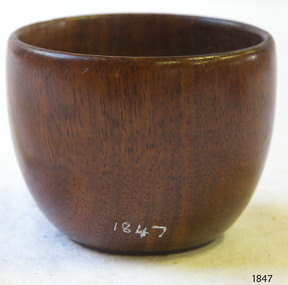
Wooden cup, missing handle. Found washed up on Elephant Bay beach, King Island 1913.flagstaff hill, warrnambool, shipwrecked-coast, flagstaff-hill, flagstaff-hill-maritime-museum, maritime-museum, shipwreck-coast, flagstaff-hill-maritime-village -
 Port Melbourne Historical & Preservation Society
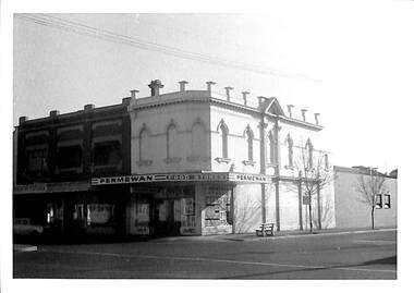
Photograph - Permewan shop, 285 Bay Street, cnr. Pool Street, Port Melbourne, Janet and Allen Walsh, 1973
Shot in 1973 with particular interest in architectureSet of 31 photographs taken in June and July 1973 Bay St and Pool St. Permewan shopIdentified and dated on back in inkbuilt environment - commercial, built environment - domestic, built environment - industrial, janet walsh, allen walsh, bay street, pool street, permewan -
Port Melbourne Historical & Preservation Society
Photograph - Morley's Coal Depot, Bay Street, Port Melbourne, Ron Laing, 1990s
Part of Ron LAING's collection of photographs recording Port Melbourne over a thirteen year period. Donated to the PMH&PS by the photographer.A set of 5 photographs showing detailed sections of the Morley's Coal Depot on the corner of Bay and Beach Streetsbuilt environment - commercial, ron laing, morley's coal depot -
 Port Melbourne Historical & Preservation Society
Photograph - Bay Street and Faram Bros, Port Melbourne, 1980
B&W photo of Bay Street and Faram Bros from south of Raglan Street c 1980built environment - commercial, business and traders, business and traders - hardware, tony cannatelli, faram brothers hardware, bay street -
Port Melbourne Historical & Preservation Society
Photograph - Flats area around Little Bay Street, 2008
.01 - CD containing Ed Whitings digital images of the "Flats" area around Little Bay Stbuilt environment, violet wood, jean barnett, edwin whiting -
 Port Melbourne Historical & Preservation Society
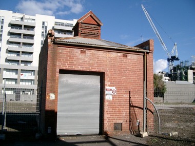
Photograph - Electrical sub-ststaion on block cleared for Muir development, Bay Street, Port Melbourne, Glen Stuart, Jun 2005
On land cleared for proposed "Muir" development not continued.at this point in 20052 colour photos of CitiPower sub-station left standing in block cleared for redevelopment on Bay Street.built environment - commercial, muir, sub-station -
Port Melbourne Historical & Preservation Society
Photograph - Window guard, National Bank building, Bay Street, Port Melbourne, David Thompson, c. 1998
One of four colour photographs of National Bank in Bay Street c 1998: decorative window guardbuilt environment - commercial -
Port Melbourne Historical & Preservation Society
Photograph - Architectural detail, National Bank building, Bay Street, Port Melbourne, David Thompson, c. 1998
One of four colour photographs of National Bank in Bay Street c 1998: detail of building architecturebuilt environment - commercial -
Port Melbourne Historical & Preservation Society
Photograph - Architectural detail, National Bank building, Bay Street, Port Melbourne, David Thompson, c. 1998
One of four colour photographs of National Bank in Bay Street c 1998: detail of building architecturebuilt environment - commercial -
Port Melbourne Historical & Preservation Society
Photograph - Sweet Port, Bay Street, Port Melbourne, David Thompson, 1990s
One of five colour photographs of Port Melbourne streets: Sweet Port shop, 175 Bay Streetbuilt environment - commercial, bay street -
Port Melbourne Historical & Preservation Society
Functional Object - Wrapping paper, Capace, Bay Street, Port Melbourne, 1980s
Capace was a family delicatessen owned and operated by Con Talarico in the 1980s, one of the first shops reflecting the gentrification of Port Melbourne. Con was renowned for his friendliness, and for his active role in the community. Con's family also had 'Capace' liquor store, corner of Pool & Lalor. Sold Evans Street house & opened a wine shop in High Street, Prahran for several years. Couldn't buy house in Evans Street back so moved to Williamstown. This wrapper hung in the pantry of donor for 15 years.Wrapping paper from Capace, Italian delicatessen at 173 Bay Street, c1988. Refer cat no. 1936Price written in black inkbusiness and traders, con talorico, capace - port melbourne wine merchant, bay street -
Port Melbourne Historical & Preservation Society
Photograph - Handcart used at Faram Bros. Hardware, C. 1930
When Faram's closed in November 2006, Doug FARAM took the handcart 7 stored it at his mother's home. On her death he offered it to the PMH&PS who were unable to accept it due to lack of adequate storage. Instead, Doug provided the society with the three digital images.Three digital images of handcart used at Faram Bros. Hardware, 405 Bay Street, Port Melbourne.doug faram, faram brothers hardware, built environment - commercial -
 Port Melbourne Historical & Preservation Society
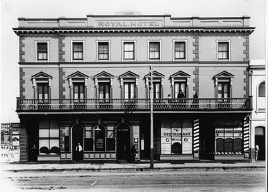
Photograph - Royal Hotel, Bay Street, Port Melbourne, 1913
Photograph of Royal Hotel in Bay Street c 1913 (built 1859), showing Lorenzo CAELLI's Restaurantbusiness and traders - hotels, business and traders - cafes and restaurants, built environment, joseph o'sullivan, lorenzo caelli -
 Bendigo Historical Society Inc.
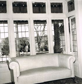
Photograph - 'MARYDALE' AXEDALE COLLECTION: PHOTOGRAPH INTERIOR AND SOFA
Interior photo of sofa in bay window area, of ''Marydale'', Axedale,looking out to garden and open fields.axedale, history, marydale property -
 Williamstown High School
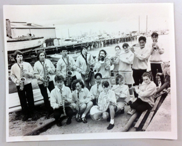
Music by the Bay 1990's
Black and white photograph of the the Williamstown High School Concert Band during Music by the Bay in the 1990's.williamstown high school, music, music by the bay, 1990's, concert band -
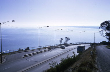 Robin Boyd Foundation
Slide, Robin Boyd, 1967
Colour slide in a mount. View of Port Phillip Bay, Nepean Highway, Olivers Hill, Frankston, VictoriaMade in Australia / 20 / JUN 67M1 / Encircled 44 (Handwritten)slide, robin boyd -
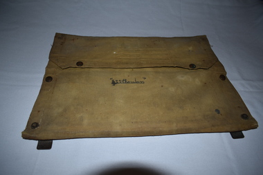 Dandenong/Cranbourne RSL Sub Branch
Functional object - Canvas document satchel
Canvas document folder with metal frame. Contents include maps of Gembrook ( Victoria ) and Shoalwater Bay ( Queensland ).Name inscribed on front " L . Chambers." -
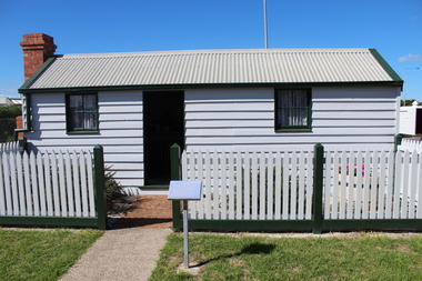 Queenscliffe Maritime Museum
Functional object - Fishermans Cottage, Built in 1870/1880 for Thomas and Anna Ikin
This low-lying northern-most tip of Queenscliff saw its physical origins in 1863 with allotments let to a burgeoning fishing community previously accommodated on the site of the current railway station and whose construction in 1879 necessitated eviction. Among this community, Chinese fishermen are thought to be of the first international settlers. The success of the fishermen’s settlement was due in part to commercial trading prospects the railway afforded and the size of catch available to those fishing in Bass Strait. Salmon, snapper and particularly barracouta led to the success of the local industry.Original Fishermans Cottage previously located at Swan Bay end of Bridge Street Queenscliff. Timber - Weatherboardfishermen's cottage, fishermen's flat, queenscliff -
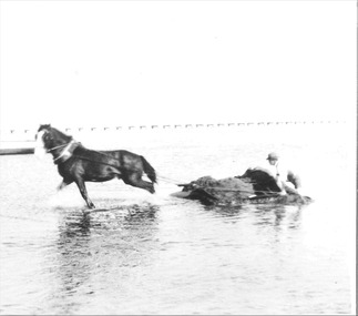 Queenscliffe Maritime Museum
Photograph - Photo of a horse drawn dredge digging the channel aka The Cut, Photograph of boat channel creation series, 1934-36
QUEENSCLIFFE boat channel being dug out c1934-36Boat channel for fishing fleet protectionBlack & white photo of horse drawn sand dredge digging the channel, aka The Cut, at the Bay end.Reverse - NILcommunity information, boat channel c1934-36, the cut, horse drawn dredge -
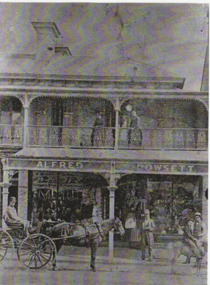 Port Melbourne Historical & Preservation Society
Photograph - Alfred Dowsett's shop, Bay Street, 1880s
Laser copy of photograph of Alfred Dowsett's (clothier and draper) shop, 305 Bay Street c 1880sbuilt environment - commercial, business and traders - tailors and clothing, alfred dowsett, bay street -
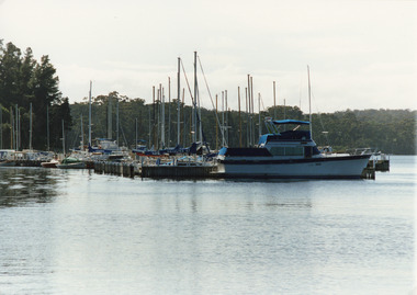 Lakes Entrance Historical Society
Photograph - Bancroft Bay, Tambo Shire, 1994
Also second identical copyColour photograph of Metung Marina on Bancroft Bay, showing yachts and cruisers moored at the jetties. Metung Victoriahouses, waterways, boats and boating -
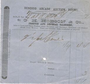 Bendigo Historical Society Inc.
Document - INVOICE COLLECTION: BENDIGO ARCADE AUCTION ROOMS INVOICE, 1897
Bendigo Arcade Auction Rooms Invoice : Invoice is blue in colour printed in black with 'Hargreaves Street, Bendigo 28/01/1897. Sold for Mr Waldock. By G.H. Hobson & Co., Produce and General Salesmen. Sales of Farm, Furniture and General Goods. Box 625T.J. Symes, Printer, Bendigo Arcade.business, retail, auction rooms, bendigo arcade auction rooms. g>h>hobson & co -
Port Melbourne Historical & Preservation Society
Poster - Public Transport Victoria, stylised view of Bay Street, Port Melbourne, Public Transport Victoria, 2017
Art deco style representation of Bay Street Port Melbourne with palm trees, bus and Mediterranean looking buildings. yachts in the Bay and moon rising behind land. Reverse side pale blue with text (Charles Rennie Macintosh style font) Same image as postcard 3992.01"Take a stroll under the palms of Port Melbourne. Explore the world of Melbourne by bus."built environment, bay street, public transport victoria -
 Flagstaff Hill Maritime Museum and Village
Photograph, circa 1888
This photograph was taken close to the time of the wreck of the "Edinburgh Castle". The “Edinburgh Castle”, three-masted iron barque, was built in Glasgow, Scotland, in 1863 by J.G. Lawrie. She was 53.7 meters long and weighed 627 tons. She was owned by shipping company T Skinner and Co and registered at Liverpool, England. She sailed from 1863 to 1885 along the trade route between Scotland, China, and Singapore. In 1887 the Master, Captain J.B. Darling, sailed the “Edinburgh Castle” for its new owners Gifford & Nicholson from London to Warrnambool. Her cargo was 4,900 casks of cement for the construction of the new Warrnambool Breakwater. Over the three month journey, the ship met with rough weather and even a hurricane. On January 15th 1888 the “Edinburgh Castle” approached Lady Bay where a welcoming crowd gathered. The Port’s relief Harbour Master, Pilot Carless took over to complete the docking. As he tried to guide her, the Lighthouse Keeper signalled that the ship was too close to shore. The pilot continued on his course, causing her to ‘miss stays’ (make an incorrect tack). The crew dropped anchors and tried to lighten the load by throwing some of the casks of cement overboard but this was to no avail, and she drifted sideways in calm waters, lodging in the sand. A distress signal was sent to the coastal steamer “Julia Percy”, which spent several hours trying to pull the stranded ship away, but it would not budge. Those involved hoped to re-float the ship but efforts to save the vessel were useless. The captain and some crew stayed on board. When the weather became rough the rocket crew brought its lifesaving gear to the shore, ready to launch a line to the ship. The three men on board sent those onshore a message in a bottle to assure the on-lookers that they were quite comfortable to stay aboard. After a night of bad weather, the crew were glad to accept the rocket crew’s help and were in turn safely hauled to shore in a breeches buoy. The ship broke up quickly. Very little of the cargo could be saved. A week later all that could be seen of her was the bow and some of the stern. The beach was littered with wreckage, including cement cask fragments, for weeks. Ironically, on the morning after the ship ran aground, the very same “Edinburgh Castle” was offered for sale at an auction in Melbourne, billed as “a sound ship with all the fittings and in the best order.” The sale was completed before they heard the news that the ship was totally wrecked! Over the decades the shifting sands concealed the wreck of “Edinburgh Castle”. However, in October 1985 two local divers, Peter Ronald and Colin Goodall discovered her near the Hopkins River mouth. Peter said in his book ‘Exploring Shipwrecks of Western Victoria’, “In the midst of this sand-cloud I could clearly see row after row of neatly stacked barrels”. He remarked, “I am privileged to have had at least a glimpse of one of Warrnambool's most significant wrecks.” Some 15 – 17 ships are believed to have sunk in Lady Bay, but only two have been discovered on the seafloor; the “Edinburgh Castle” and the “La Bella”. Both wrecks are popular diving sites and are preserved as significant historical marine and marine archaeological sites. The sailing ship “Edinburgh Castle” is of local and state and national significance. It is one of the only two shipwrecks discovered in Lady Bay, Warrnambool, out of the 15-17 shipwrecks in the bay. The “Edinburgh Castle” is significant for being one of the largest vessels lost in the bay. The significance of the wreck of the “Edinburgh Castle” was recognised by being listed on the Victorian Heritage Database VHR S209. She was declared an Historic Shipwreck on 17th January 1989 under the Commonwealth Historic Shipwrecks Act (1976). The “Edinburgh Castle” wreck is also significant for the connection of its cargo with the building of the Warrnambool Breakwater, also listed on the Victorian Heritage Database VHR H2024. The “Edinburgh Castle” is included as one of the shipwrecks in Heritage Victoria’s Historic Shipwreck Trail on Victoria’s West Coast. Black and white photograph of the iron barque 'Edinburgh Castle' on breaking waves, land in the background. The ship was stranded and wrecked in Lady Bay, Warrnambool, on January 15th 1888. Figures are standing on deck. The masts are free from sails.flagstaff hill, warrnambool, shipwrecked-coast, flagstaff-hill, flagstaff-hill-maritime-museum, maritime-museum, shipwreck-coast, flagstaff-hill-maritime-village, great ocean road, edinburgh castle barque 1863, edinburgh castle shipwreck 1888, shipwreck 15-05-1888, glasgow ship, jg lawrie, t skinner and co, liverpool ship register, captain j.b. darling, gifford & nicholson, cement casks, cement barrels, warrnambool breakwater construction, breaches buoy, rocket crew, rocket launcher, lifesaving equipment, warrnambool harbour, lady bay warrnambool, ship pilot carless, lady bay shipwreck, peter ronald, colin goodall, lady bay diving site, marine archaeology, victorian heritage register, vhr s209 -
City of Kingston
Photograph - Colour, 29 January 1993
Bonbeach, Carrum and Patterson Lakes are suburbs in the City of Kingston. Bonbeach and Carrum were holiday destinations in early 20th century and over time the housing has converted to permanent residential structures. In Patterson Lakes, the area consists predominantly of newer housing developments and the tidal canal system which is accessible to many dwellings joins Port Phillip Bay.Bonbeach, Carrum and Patterson Lakes were previously part of the extensive Carrum Carrum Swamp. The area was once a source of fish and eels for the Mayone-Bulluk clan of the Bunurong people. Over time the area was drained and this allowed farming at Carrum and Bonbeach, although the area was prone to flooding. In the early 1920s and 30s the land was converted to residential dwellings. In 1973 investigations commenced nearby to Bonbeach and Carrum into the development of a unique residential area comprising canals and waterways. It was originally proposed to be known as "Gladesville". Circa 1974, the area was rezoned from rural to residential and named Patterson Lakes. Development has been continuous since the 1970s with staged construction of the waterways, residential housing, and supporting infrastructure and facilities.Laminated colour aerial photograph of the Bonbeach, Carrum and Patterson Lakes region within City of Kingston. This 1993 image includes Bonbeach High School prior to demolition, Bonbeach Primary School and Patterson River Golf Club. Sections of Patterson Lakes are not yet developed, including Rhode and Staten Islands. Long Island Point appears to be a recent development with many spare blocks and new houses under construction. The Patterson River marina is prominent and the river mouth as it meets Port Phillip Bay. The Carrum railway station is visible.Black type on white adhesive sticker: No. 6661 Black type on white adhesive sticker: 26E/6661, 29/1/93, 4.25 pm Black type on white adhesive sticker 29-1-93 Yellow circular adhesive stickerbonbeach, carrum, patterson lakes, patterson river, carrum carrum swamp, canals and waterways -
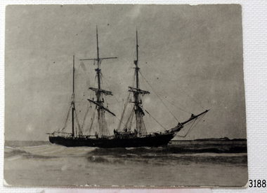
 Flagstaff Hill Maritime Museum and Village
Photograph
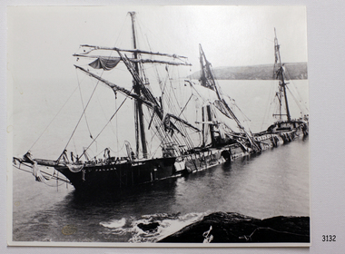
Black and White Photograph of sail ship Bay of Panama. 253mm x 204mm. SH 041 Ships A - B.flagstaff hill, warrnambool, shipwrecked-coast, flagstaff-hill, flagstaff-hill-maritime-museum, maritime-museum, shipwreck-coast, flagstaff-hill-maritime-village, bay of panama, photograph -
 Flagstaff Hill Maritime Museum and Village
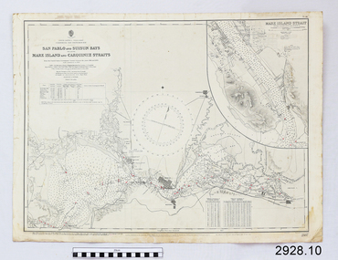
Document - Navigation Chart, California - San Pablo and Suisun Bays including Mare Island and Carquinez straits
British Admiralty Navigation Chart - California - San Pablo and Suisun Bays including Mare Island and Carquinez Straitswarrnambool, shipwrecked-coast, flagstaff-hill, flagstaff-hill-maritime-museum, maritime-museum, shipwreck-coast, flagstaff-hill-maritime-village, shipwrecked-artefact, british admiralty navigation chart, navigation chart, california, suisun bay, san pablo bay, mare island strait, carquinez straitt