Showing 835 items
matching parish map
-
 Ringwood and District Historical Society
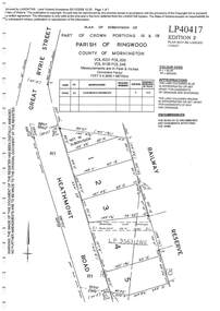
Document - Subdivision Plan, LP40417 Part of Crown Portions 16 & 18, Parish of Ringwood, County of Mornington, Vol 6231 Fol 035 and Vol 8139 Fol 248 - 1957
LANDATA Land Victoria plan printout dated 2008Map includes Heathmont Road, Heathmont, with allotments adjoining Railway Reserve. Other markings include LP95632NS. -
 Ringwood and District Historical Society
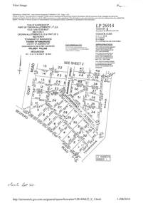
Document - Subdivision Plan, LP26914 Multiple Crown Allotments, Parish of Ringwood, County of Mornington, Vol 8021 Fol 053 - 1954
LANDATA Land Victoria plan printout dated 2010Part of Crown Allotments 1, 1A, 2, 3, 4, 5, 6, 7, 8, 9, 10, 55, 56, 57. Section C Crown Allotments 3, 12 & part of 2. Section B Map includes Bedford Road, Government Road (later Bedford Park Road then Hill Street), Marwarra Street and Tooronga Road, Ringwood. (Sheet 1 of 2 - Sheet 2 not included with collection). -
 Ringwood and District Historical Society
Document - Subdivision Plan, LP10477 Parish of Warrandyte, County of Evelyn, Vol 2453 Fol 574 - 1924
LANDATA Land Victoria plan printout circa 2010Part of Crown Allotment 30. Map includes Warrandyte Road, Kennedy Avenue and Wonga Road, Ringwood. Street name amended from Wonga Road to Loughnan Road 1940. Other markings include CP102182, CP171386, LP127934, PS349846, RP7582, PS309312,RP8679 and CP106336. -
 Ringwood and District Historical Society
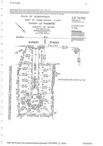
Document - Subdivision Plan, LP76792 Part of Crown Portions 19 & 20A, Parish of Ringwood, County of Bourke, Vol 8382 Fol 140 - 1967
LANDATA Land Victoria plan printout dated 2010Map includes Rupert Street and Prospect Court, Ringwood. -
 Ringwood and District Historical Society
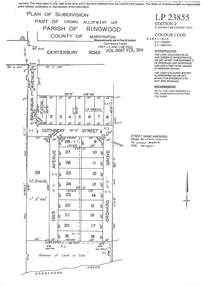
Document - Subdivision Plan, LP23855 Part of Crown Allotment 14B, Parish of Ringwood, County of Mornington, Vol 6687 Fol 394 - 1952
LANDATA Land Victoria plan printout circa 2008Map includes Cuthbert Street, Orchard Grove, and Lowen Avenue (formerly part of Balfour Avenue), Heathmont. Other markings include SP25736, LP98835 and LP40209. -
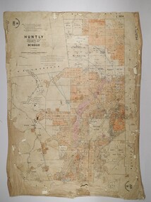 Bendigo Historical Society Inc.
Map - HUNTLY, 16/11/1903
... MAP Bendigo parish plan Bartholomew Becket W S Stephen J ...Map: Huntly, County of Bendigo. Parish plan. Drawn by Bartholomew Becket, examined by W S Stephen 15/3/80, examined by J Walshe Sept 1903, additions H Hansford August 1903map, bendigo, parish plan, bartholomew becket, w s stephen, j walshe, h hansford, huntly -
 Stawell Historical Society Inc
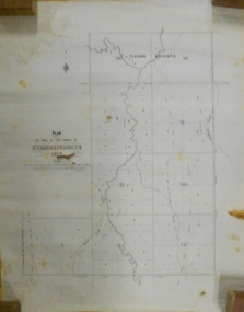
Map, Department of Lands and Survey Melbourne, Swinton Estate. Parish of Riachella. County of Borong, 3-08-1921
Shows part of Warranook TrainwayA1 Printed Map With Cloth Backing. Annotations in Red Ink W.J. Butson 3-8-21farming -
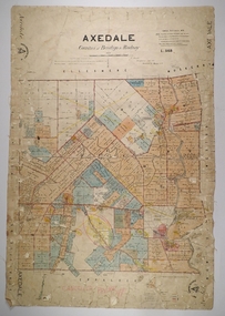 Bendigo Historical Society Inc.
Map - AXEDALE, 26/07/1877
... MAP Bendigo parish plan Axedale E. Daniell Harvey Map ...Map: Axedale, Counties of Bendigo and Rodney. Parish plan Draughtsman E. Daniell Sept. 1876. Examined by Harvey 1/6/1877map, bendigo, parish plan, axedale, e. daniell, harvey -
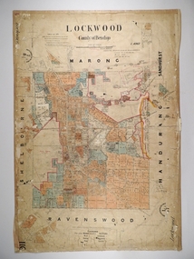 Bendigo Historical Society Inc.
Map - LOCKWOOD, 13/03/1876
... MAP Bendigo parish plan Lockwood W. P. Blake Map: Lockwood ...Map: Lockwood, County of Bendigo. Parish plan. Compiled Jan. 1876. W. P. Lake Draftsman. paper on canvas backing.map, bendigo, parish plan, lockwood, w. p. blake -
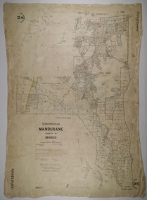
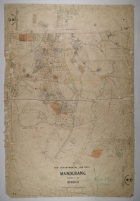 Bendigo Historical Society Inc.
Map - MANDURANG 1, Examined 11/12/1879
... MAP Bendigo parish plan Mandurang W. S. Stephen W. E ...Map: Mandurang 2, County of Bendigo. Parish plan Examined by W. S. Stephen 11.12.79 W. E. Porter Draughtsman July 1879map, bendigo, parish plan, mandurang, w. s. stephen, w. e. porter -
 Bendigo Historical Society Inc.
Map - MANDURANG 3, 10/11/1909
... MAP Bendigo parish plan Mandurang W. S. Stephen W. E ...Map: Mandurang, County of Bendigo. Parish plan Examined by W. S. Stephen 11.12.79 W. E. Porter Draughtsman July 1879map, bendigo, parish plan, mandurang, w. s. stephen, w. e. porter -
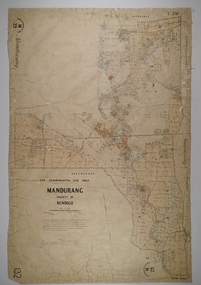 Bendigo Historical Society Inc.
Map - MANDURANG 2, Date unreadable
... MAP Bendigo parish plan Mandurang W.S. Stephen W. E. Porter ...Map: Mandurang, County of Bendigo. Parish plan Examined by W. S. Stephen 11.12.79 W. E. Porter Draughtsman July 1879map, bendigo, parish plan, mandurang, w.s. stephen, w. e. porter -
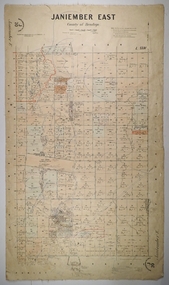 Bendigo Historical Society Inc.
Map - JANIEMBER EAST, 26/07/1879
... MAP Bendigo parish plan Janiember East Serpentine Map ...Map: Janiember East, County of Bendigo. Parish plan Examined by T Pures 16.10.75 S M Reed August 1875map, bendigo, parish plan, janiember east, serpentine -
 Bendigo Historical Society Inc.
Map - SANDHURST SHEETS 1 AND 2, No date visible
... MAP Bendigo parish plan Sandhurst Map: Sandhurst sheets 1 ...Map: Sandhurst sheets 1 and 2. Parish planmap, bendigo, parish plan, sandhurst -
 Bendigo Historical Society Inc.
Document - MARKS COLLECTION: STRATHFIELDSAYE PLAN 1854
Plan drawn on light paper. Written on LH side of plan 'Plan of Part of the Parish of Strathfieldsaye 1854. Scale (shown) Lithographed at the Surveyor Generals Office, Melbourne July 10th. By I. Jones'. Plan shows Emu Creek and Village Reserve at top of plan, Shepherd's Creek on RH side, Parish Boundary Line on RH and bottom of plan.map, bendigo, shire of strathfieldsaye 1854 -
 Bendigo Historical Society Inc.
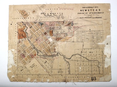
Map - NEWSTEAD, 28/07/1874
... , Parish of Strangways. Parish plan Map NEWSTEAD ...Map: Newstead Town and Suburban Lots, Parish of Strangways. Parish planmap, township, newstead -
 Bendigo Historical Society Inc.
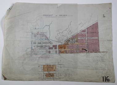
Map - WALMER, Circa 1900
... Draughted Parish plans Map WALMER ...Map: Township of Walmer, 2 hand Draughted Parish plansmap, township, walmer -
 Bendigo Historical Society Inc.
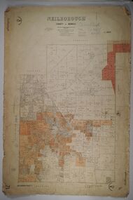
Map - NEILBOROUGH, 27/09/1904
... MAP Bendigo parish plan Neilborough Map: Neilborough ...Map: Neilborough, County of Bendigo. Parish planmap, bendigo, parish plan, neilborough -
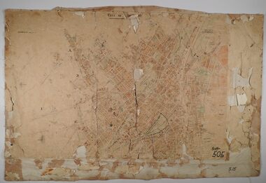
 Bendigo Historical Society Inc.
Map - CITY OF SANDHURST RESURVEY SHEET 1, 21/05/1881
... MAP Bendigo parish plan Sandhurst Resurvey Map: City ...Map: City of Sandhurst resurvey sheet 1. Parish plan showing the Southeastern corner of the Municipalitymap, bendigo, parish plan, sandhurst, resurvey -
 Bendigo Historical Society Inc.
Map - BENDIGO SHEET 2, Circa 1900
... Map: Bendigo sheet 2 . Parish plan...MAP Bendigo parish plan Bendigo Map: Bendigo sheet 2 ...Map: Bendigo sheet 2 . Parish planmap, bendigo, parish plan, bendigo -
 Bendigo Historical Society Inc.
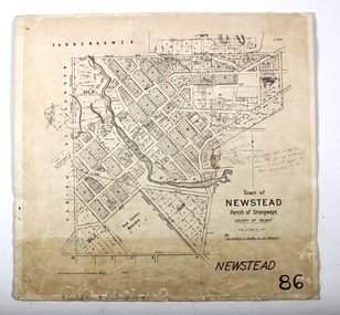
Map - NEWSTEAD, 15/10/1912
... Map: Town of Newstead, Parish of Strangways, County... of Newstead, Parish of Strangways, County of Talbot Map NEWSTEAD ...Map: Town of Newstead, Parish of Strangways, County of Talbotmap, talbot, township, newstead, county of talbot -
 Ringwood and District Historical Society
Document - Subdivision Map, Part of Crown Portion 22 Parish of Ringwood, County of Mornington. Vol 1915 Fol 827 - LP2427
LANDATA Land Victoria 4-sheet plan dated January 2003 - copy of original 1889 subdivision, amended with 1947 amendments by Assistant Registrar of Titles.Sheet 1 includes Main Lilydale Road (later Old Lilydale Road), Wandin Road (later Mount Dandenong Road), and Joseph Street, Ringwood East. Additional Plan markings SP30844, SP32804, LP144251, PS332061, PS305232. Sheet 2 includes Main Lilydale Road (later Old Lilydale Road), Wandin Road (later Mount Dandenong Road), and Dynes Street, Ringwood East. Additional Plan markings LP43708, LP44231, LP124702. Sheet 3 includes Main Lilydale Road (later Old Lilydale Road), Dynes Street, Albert Street (later Wyrunga Street), and Carcoola Road, Ringwood East. Additional Plan markings LP114181, LP114180, LP18261, LP214030, LP67300, PS354509, PS335500. Sheet 4 includes Main Lilydale Road (later Old Lilydale Road), Albert Street (later Wyrunga Street), and Carcoola Road, Ringwood East. Additional Plan markings PS315494, PS319495. -
 Bendigo Historical Society Inc.
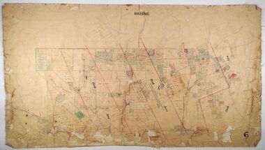
Map - MARONG, Circa 1871
... Map; Marong, Hand Draughted parish plan...MAP Bendigo parish plan Marong Map; Marong, Hand Draughted ...Map; Marong, Hand Draughted parish planmap, bendigo, parish plan, marong -
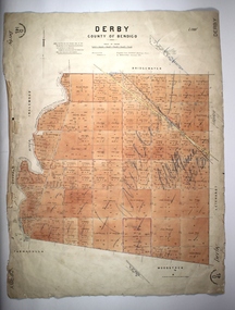 Bendigo Historical Society Inc.
Map - DERBY, 12/05/1892
... MAP Bendigo parish plan Derby Map: Derby, County of Bendigo ...Map: Derby, County of Bendigo. Paris planmap, bendigo, parish plan, derby -
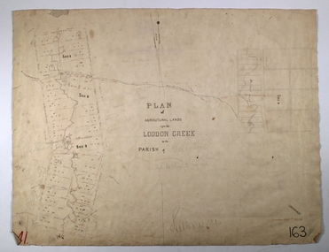 Bendigo Historical Society Inc.
Map - LODDON CREEK, Circa 1860
... Creek in the parish of Shelbourne Map LODDON CREEK ...Map: Plan of agricultural lands upon the Loddon Creek in the parish of Shelbournemap, bendigo, agricultural lands, agricultural lands, loddon creek, shelbourne -
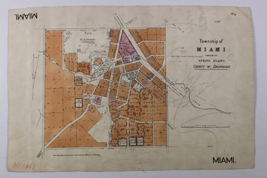 Bendigo Historical Society Inc.
Map - MIAMI ( MIA MIA), 26/06/1906
The name Miami on the is a misprint Map: Township of Miami (Mia Mia), Parish of Spring Plains, County of Dalhousiemap, dalhousie, township, mia mia, spring plains creek -
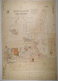 Bendigo Historical Society Inc.
Map - METCALFE, 30/10/1878
... MAP Dalhousie parish plan Metcalfe F. J. Vincent Map ...Map: Metcalfe, County of Dalhousie. Parish plan (also has a smaller addition glued onto the right hand side) F. J. Vincent Draftsman Oct. 1876 Ex (unreadable signature) Oct 1878map, dalhousie, parish plan, metcalfe, f. j. vincent -
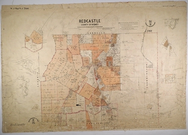 Bendigo Historical Society Inc.
Map - REDCASTLE, 15/10/1878
... MAP Rodney parish plan Redcastle T. S. hall E. D. Downward ...Map: Redcastle, County of Rodney. Parish plan. Examined E. D. Downward 28.9.78 T, S Hall Aug 78map, rodney, parish plan, redcastle, t. s. hall, e. d. downward -
 Ringwood and District Historical Society
Document - Subdivision Map, Part of Crown Sections 18, 19, 24 & 25, Parish of Warrandyte, County of Evelyn, Vol 5228 Fol 472 - 1926. (Park Orchards, Victoria)
A3 and A4 sized photocopies showing map section of land title showing streets, easements and allotment numbers, some with handwritten names and pricing notations circa mid 1950s.Map includes Valley Road, Granard Avenue, Park Road, Arundel Avenue, Hylton Avenue, Aviemore Avenue, Bowmore Avenue, Hopetoun Road, Colin Avenue, Daintree Avenue, Brucedale Crescent, Feversham Avenue, Ennismore Crescent, Iona Grove, Elgin Crescent and Gosford Crescent, Park Orchards, Victoria. -
 Ringwood and District Historical Society
Document - Map, Plan of Subdivision - Part of Crown Allotments 14A & 14C, Parish of Ringwood, County of Mornington, Vol 5378 Fol 511 - 1927
Department of Lands and Survey photocopy dated 17/1/1951, page number 12308.Map includes Canterbury Road, Heathmont Road, Dickasons Road, Bennett Avenue, Orchid Street and Allens Road, Heathmont, Vic.