Showing 9134 items
matching photo’s
-
 Ringwood and District Historical Society
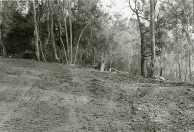
Photographs, 1979-80 MMBW pipe line project at Hubbard Reserve, North Ringwood � Broken mole
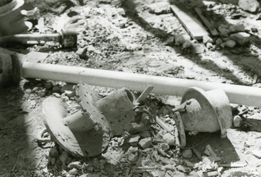
Part of a 43-photo record of the MMBW�s engineering feat in drilling a 12 inch pipe line up to 40 feet deep through rock hardened by volcanic action associated with geological fault that occurs along the line. The work took place from October 1979 to May 1980 on the southern boundary of Hubbard Reserve, North Ringwood. The collection was presented to the Ringwood Historical Research Group by J Clarke on 9th June 1980.E565 N9 16 April 1980 A43 The broken mole back-reamer whose jamming held up the job for four weeks -
 Ringwood and District Historical Society
Photographs, 1979-80 MMBW pipe line project at Hubbard Reserve, North Ringwood � Viewing east from Debbie Place
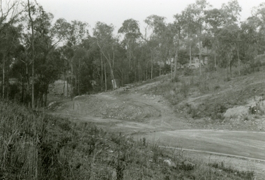
Part of a 43-photo record of the MMBW�s engineering feat in drilling a 12 inch pipe line up to 40 feet deep through rock hardened by volcanic action associated with geological fault that occurs along the line. The work took place from October 1979 to May 1980 on the southern boundary of Hubbard Reserve, North Ringwood. The collection was presented to the Ringwood Historical Research Group by J Clarke on 9th June 1980.E568 N18 13 May 1980 A43 Viewing east from ridge above Debbie Place -
 Ringwood and District Historical Society
Photographs, 1979-80 MMBW pipe line project at Hubbard Reserve, North Ringwood � View east up the gully
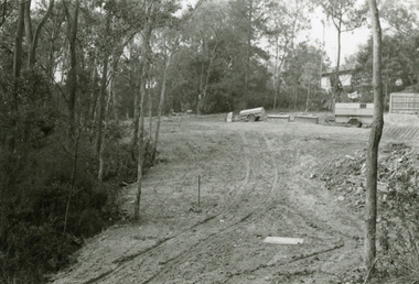
Part of a 43-photo record of the MMBW�s engineering feat in drilling a 12 inch pipe line up to 40 feet deep through rock hardened by volcanic action associated with geological fault that occurs along the line. The work took place from October 1979 to May 1980 on the southern boundary of Hubbard Reserve, North Ringwood. The collection was presented to the Ringwood Historical Research Group by J Clarke on 9th June 1980.E568 N19 13 May 1980 A43 View east up the gully, when all the work was finished -
 Ringwood and District Historical Society
Photographs, 1979-80 MMBW pipe line project at Hubbard Reserve, North Ringwood � Looking east near Debbie Place
Part of a 43-photo record of the MMBW�s engineering feat in drilling a 12 inch pipe line up to 40 feet deep through rock hardened by volcanic action associated with geological fault that occurs along the line. The work took place from October 1979 to May 1980 on the southern boundary of Hubbard Reserve, North Ringwood. The collection was presented to the Ringwood Historical Research Group by J Clarke on 9th June 1980.E567 N16 13 May 1980 A43 Looking east from the ridge above Debbie Place. The finished manhole is in the gully. -
 Ringwood and District Historical Society
Photographs, 1979-80 MMBW pipe line project at Hubbard Reserve, North Ringwood � View east from Debbie Place
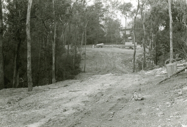
Part of a 43-photo record of the MMBW�s engineering feat in drilling a 12 inch pipe line up to 40 feet deep through rock hardened by volcanic action associated with geological fault that occurs along the line. The work took place from October 1979 to May 1980 on the southern boundary of Hubbard Reserve, North Ringwood. The collection was presented to the Ringwood Historical Research Group by J Clarke on 9th June 1980.E558 N29 13 May 1980 A43 View east from Debbie Place -
 Ringwood and District Historical Society
Photographs, 1979-80 MMBW pipe line project at Hubbard Reserve, North Ringwood � Track down to creek bridge
Part of a 43-photo record of the MMBW�s engineering feat in drilling a 12 inch pipe line up to 40 feet deep through rock hardened by volcanic action associated with geological fault that occurs along the line. The work took place from October 1979 to May 1980 on the southern boundary of Hubbard Reserve, North Ringwood. The collection was presented to the Ringwood Historical Research Group by J Clarke on 9th June 1980.E565 N12 13 May 1980 A43 My old track down to the bridge over the creek. The pipe line went to the right of the big tree 40-foot down. -
 Ringwood and District Historical Society
Photographs, 1979-80 MMBW pipe line project at Hubbard Reserve, North Ringwood � The new trach goes on down to Debbie Place
Part of a 43-photo record of the MMBW�s engineering feat in drilling a 12 inch pipe line up to 40 feet deep through rock hardened by volcanic action associated with geological fault that occurs along the line. The work took place from October 1979 to May 1980 on the southern boundary of Hubbard Reserve, North Ringwood. The collection was presented to the Ringwood Historical Research Group by J Clarke on 9th June 1980.E566 N13 13 May 1980 A43 The parting of the ways. My old track goes left to Burlock Avenue. The new way goes on down to Debbie Place. -
 Ringwood and District Historical Society
Photographs, 1979-80 MMBW pipe line project at Hubbard Reserve, North Ringwood � Manhole behind 29 Burlock Avenue
Part of a 43-photo record of the MMBW�s engineering feat in drilling a 12 inch pipe line up to 40 feet deep through rock hardened by volcanic action associated with geological fault that occurs along the line. The work took place from October 1979 to May 1980 on the southern boundary of Hubbard Reserve, North Ringwood. The collection was presented to the Ringwood Historical Research Group by J Clarke on 9th June 1980.E566 N5 13 May 1980 A43 Manhole behind 29 Burlock Avenue, 38 feet deep. Debbie place is on the far right. -
 Ringwood and District Historical Society
Photographs, 1979-80 MMBW pipe line project at Hubbard Reserve, North Ringwood � The manhole in the creek
Part of a 43-photo record of the MMBW�s engineering feat in drilling a 12 inch pipe line up to 40 feet deep through rock hardened by volcanic action associated with geological fault that occurs along the line. The work took place from October 1979 to May 1980 on the southern boundary of Hubbard Reserve, North Ringwood. The collection was presented to the Ringwood Historical Research Group by J Clarke on 9th June 1980.E563 1 April 1980 A43 The manhole in the creek, waiting until boring is finished. -
 Ringwood and District Historical Society
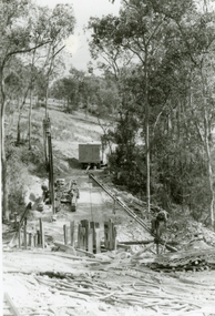
Photographs, 1979-80 MMBW pipe line project at Hubbard Reserve, North Ringwood � Tracked drill rig
Part of a 43-photo record of the MMBW�s engineering feat in drilling a 12 inch pipe line up to 40 feet deep through rock hardened by volcanic action associated with geological fault that occurs along the line. The work took place from October 1979 to May 1980 on the southern boundary of Hubbard Reserve, North Ringwood. The collection was presented to the Ringwood Historical Research Group by J Clarke on 9th June 1980.E561 N16 3 March 1980 A43 Tracked drill rig on the line of trench for sewer to Debbie Place -
 Ringwood and District Historical Society
Photographs, 1979-80 MMBW pipe line project at Hubbard Reserve, North Ringwood � Air track drill rig
Part of a 43-photo record of the MMBW�s engineering feat in drilling a 12 inch pipe line up to 40 feet deep through rock hardened by volcanic action associated with geological fault that occurs along the line. The work took place from October 1979 to May 1980 on the southern boundary of Hubbard Reserve, North Ringwood. The collection was presented to the Ringwood Historical Research Group by J Clarke on 9th June 1980.E561 N19 3 March 1980 A43 Air track drill rig in position as in N18 -
 Ringwood and District Historical Society
Photographs, 1979-80 MMBW pipe line project at Hubbard Reserve, North Ringwood � Last days of the boring
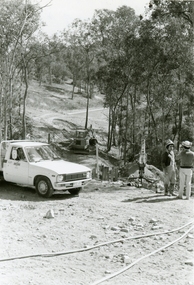
Part of a 43-photo record of the MMBW�s engineering feat in drilling a 12 inch pipe line up to 40 feet deep through rock hardened by volcanic action associated with geological fault that occurs along the line. The work took place from October 1979 to May 1980 on the southern boundary of Hubbard Reserve, North Ringwood. The collection was presented to the Ringwood Historical Research Group by J Clarke on 9th June 1980.E561 N1 1 April 1980 A43 Last days of the boring. The mole had broken between the last two shafts. Dominic Di Nezza and Glen Pearson discuss further moves to release it. -
 Ringwood and District Historical Society
Photographs, 1979-80 MMBW pipe line project at Hubbard Reserve, North Ringwood � Drill rig
Part of a 43-photo record of the MMBW�s engineering feat in drilling a 12 inch pipe line up to 40 feet deep through rock hardened by volcanic action associated with geological fault that occurs along the line. The work took place from October 1979 to May 1980 on the southern boundary of Hubbard Reserve, North Ringwood. The collection was presented to the Ringwood Historical Research Group by J Clarke on 9th June 1980.E561 N17 3 March 1980 A43 Powder-monkey marks out the spots for holes -
 Ringwood and District Historical Society
Photographs, 1979-80 MMBW pipe line project at Hubbard Reserve, North Ringwood � View towards Debbie Place
Part of a 43-photo record of the MMBW�s engineering feat in drilling a 12 inch pipe line up to 40 feet deep through rock hardened by volcanic action associated with geological fault that occurs along the line. The work took place from October 1979 to May 1980 on the southern boundary of Hubbard Reserve, North Ringwood. The collection was presented to the Ringwood Historical Research Group by J Clarke on 9th June 1980.E561 N15 3 March 1980 A43 View towards Debbie Place, showing 2 swivel cranes at shafts, timber of manhole in creek, the tracked drill rig and its compressor caravan. -
 Ringwood and District Historical Society
Photographs, 1979-80 MMBW pipe line project at Hubbard Reserve, North Ringwood � Boring mole pit
Part of a 43-photo record of the MMBW�s engineering feat in drilling a 12 inch pipe line up to 40 feet deep through rock hardened by volcanic action associated with geological fault that occurs along the line. The work took place from October 1979 to May 1980 on the southern boundary of Hubbard Reserve, North Ringwood. The collection was presented to the Ringwood Historical Research Group by J Clarke on 9th June 1980.E561 N14 3 March 1980 A43 View west behind No. 29 Burlock Avenue, showing gantry over manhole 38 feet deep. -
 Ringwood and District Historical Society
Photographs, 1979-80 MMBW pipe line project at Hubbard Reserve, North Ringwood � The work on sewer line from 29-39 Burlock Avenue
Part of a 43-photo record of the MMBW�s engineering feat in drilling a 12 inch pipe line up to 40 feet deep through rock hardened by volcanic action associated with geological fault that occurs along the line. The work took place from October 1979 to May 1980 on the southern boundary of Hubbard Reserve, North Ringwood. The collection was presented to the Ringwood Historical Research Group by J Clarke on 9th June 1980.E561 N11 3 March 1980 A43 The work on sewer line from 29-39 Burlock Avenue. Lundy-Clarke's place on sky-line. -
 Ringwood and District Historical Society
Photographs, 1979-80 MMBW pipe line project at Hubbard Reserve, North Ringwood � View from Debbie Place, preliminary sewer work
Part of a 43-photo record of the MMBW�s engineering feat in drilling a 12 inch pipe line up to 40 feet deep through rock hardened by volcanic action associated with geological fault that occurs along the line. The work took place from October 1979 to May 1980 on the southern boundary of Hubbard Reserve, North Ringwood. The collection was presented to the Ringwood Historical Research Group by J Clarke on 9th June 1980.E561 N13 28 Feb 1980 A43 View from Debbie Place, preliminary sewer work -
 Ringwood and District Historical Society
Photographs, 1979-80 MMBW pipe line project at Hubbard Reserve, North Ringwood � Line of tunnel shafts behind 29-39 Burlock Avenue
Part of a 43-photo record of the MMBW�s engineering feat in drilling a 12 inch pipe line up to 40 feet deep through rock hardened by volcanic action associated with geological fault that occurs along the line. The work took place from October 1979 to May 1980 on the southern boundary of Hubbard Reserve, North Ringwood. The collection was presented to the Ringwood Historical Research Group by J Clarke on 9th June 1980.E561 N10 Feb 1980 A43 Line of tunnel shafts behind 29-39 Burlock Avenue. Horizontal gantry was above the manhole in the corner of No. 29. -
 Ringwood and District Historical Society
Photographs, 1979-80 MMBW pipe line project at Hubbard Reserve, North Ringwood � First hole west of bore hole at 39 Burlock Avenue
Part of a 43-photo record of the MMBW�s engineering feat in drilling a 12 inch pipe line up to 40 feet deep through rock hardened by volcanic action associated with geological fault that occurs along the line. The work took place from October 1979 to May 1980 on the southern boundary of Hubbard Reserve, North Ringwood. The collection was presented to the Ringwood Historical Research Group by J Clarke on 9th June 1980.E561 N9 Feb 1980 A43 First hole west of bore hole at 39 Burlock Avenue -
 Ringwood and District Historical Society
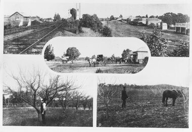
Photograph, Photos from a Weekly Times newspaper article featuring images of early Ringwood and East Ringwood circa 1910 (6 photos), Circa 1910
Shops, houses and hotel(s) were originally regarded as being in central Ringwood and later as Ringwood East after the commercial and residential developments gradually centered further west around the Railway Station precinct after train services commencedFive photographs; Ringwood Railway Crossing; Ringwood Shopping Strip; Pruning Demonstration; Shops, houses and hotel(s) in Mount Dandenong Road; Ploughing.Written on backing sheet, "Photos from Weekly Times. Check with H.A." -
 Ringwood and District Historical Society
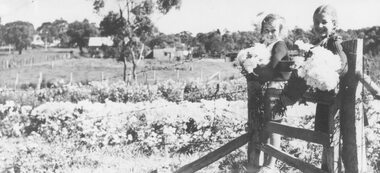
Photograph, Hazel Howship and Merle Purser with chrysanthemums at Lutch Floral Farm, East Ringwood,1939
Black and white photographAccompanying sheet of paper reads- "Chrysanthemums. Inspecting chrysanthemums while sitting on the gate of the Floral Farm of Mr. S. R. Lutch at East Ringwood on 24th April 1939. Hazel Howship and Merle Purser, daughter of Cr. Purser." "This photo appeared in the 'Herald' on Saturday Nov. 8th, 1958."agriculture -
 Ringwood and District Historical Society
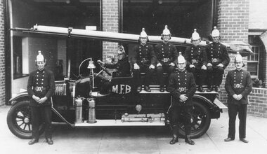
Photograph, Ringwood Fire Brigade "New" Station 1930's
Black and white photograph of firemen on cart outside brick building. (2 copies)Written on backing sheet, "Ringwood Fire Brigade New Station. 1. Sam Brown, 2. Les Jones, 3 Clarance Burns, 4. Jack Wilkins, 5. Frank King (Station Officer), 6. Dave Anderson, 7. George Burns, 8. Percy Griffen". Writing on backing sheet of second photo states photo taken in 1930s. -
 Ringwood and District Historical Society
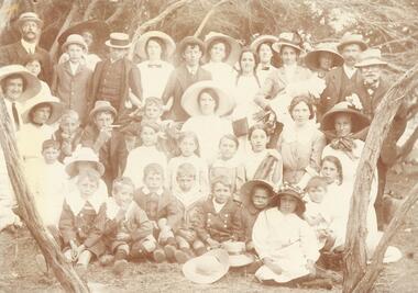
Photograph, North Ringwood & South Warrandyte residents beach picnic c1905
Image O0054b has list of namesSmaller photograph with numbers and identification attached reads as follows: "North Ringwood & South Warrandyte residents beach picnic c1905. Photo from M. zoch, Hardings Rd. South Warrandyte. 1. Mr. Daniels, 2. Marion Coleman, 3. V. Zoch, 4. Mrs. Daniels, 5. Len Milne, 6. Miss D. Coleman, 7. Mic Johansen, 8. Mrs. Johansen, 9. Miss A. Sloan, 10. Mrs. Hussey, 11. Mrs. B. Milne, 12. Mrs. Tortice, 13. Bert Milne, 14. P. Coleman, 15. Miss J. Tortice, 16. Miss S. Tortice, 17 May Tortice, 18. Mrs. J. Coleman, 19. Claude Milne, 20. Rosie Johansen, 21, M. Zoch, 22 Harold Milne, 23. Miss O. Johansen, 24. Miss F. Sloan, 25. Eileen Mitchell, 26. Amy Johansen, 27. Roy Milne, 28. Stan Milne, 29. Dave Coleman, 30. Bell Mitchell, 31. Reg Danields, 32. Vicki Tortice, 33. Harry Tortice, 34. Millie Mitchell, 35. Florrie Tortice, 36. Bill Tortice, 37 Emily Tortice". -
 Ringwood and District Historical Society
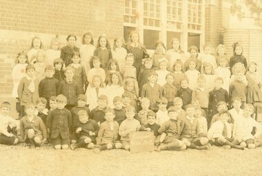
Photograph, State School, Ringwood No 2997 Grade 1&2 Students incl (undated) c early 1890s?
Poor Quality Photo, but can identify as Grade 1&2. No year given. Porbably early 1890's according to Evlie Dobbin school register entry. Written on back of photograph, "Elvie Dobbin. State School, Ringwood No 2997". -
 Ringwood and District Historical Society
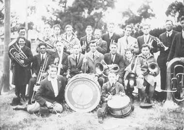
Photograph, Ringwood Citizens Brass Band, 1920
Typed below enlargement photograph, "Ringwood Citizens Brass Band, 1920". Written on back of another copy, "Ringwood Band (formed 19th September 1921). Photo taken at Reserve, 27th November 1921. Back: C. French, C. Morgan, M. Hodgkins, G. Burns, M. Joseph, H. Hammond, S. Brown, T. Mackey, H. McLoone, W. Fitzell, M. Leach. Middle: N. Wieland, W. Guy, H. Willis, L. Little, H. Bradley (Conductor), E. Homewood, W. Brown, G. Davis. Front: L. Hall, S. Hyden". -
 Orbost & District Historical Society
felt toy, 1950's
This felt deer was made by Helena warren of Newmerella. The deer was exhibited in the Royal Melbourne Show in the 1950's. Helena Francis Warren (nee McKeown) was married to William John Warren and lived in Newmerella. She was a fine amateur photographer who supplied the photos for the Back-To-Orbost celebration book in 1937 and also designed the Back-To-Orbost badge. She was known for her soft toy making. (by Ivy Rodwell in from Personalities and Stories of the Early Orbost District by Mary Gilbert).This object reflects the needlework skills of women in the early to mid 20th century. This item also has significance in its association with Helen Frances Warren, a popular Orbost identity who was well known as an accomplished photographer and needleworker,A handmade felt toy fallow deer which is light brown with darker brown spots. It has dark brown antlers, dark brown feet and plastic eyes.handcrafts needlework warren-helena -
 Orbost & District Historical Society
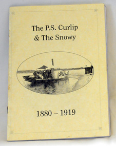
book, Winchester, Ian, The P.S. Curlip & the Snowy River 1880-1919, 2008
This book was written by Ian Winchester, the grandson of James Winchester, early settler in Marlo, who worked with Alan Richardson. The book is dedicated to those who colonised the Snowy River. James Winchester was born in Geelong in 1856. He first sailed into Marlo, aged 15 and returned in the 1870's. he worked on the snagging punt on the Snowy River and also on the Paddle Steamer Curlip which towed the barges to collect the maize grown along the Snowy River.This book is a useful reference on the history of the Paddle Steamer Curlip.A thin, 22 pp, stapled paperback book, titled "P.S. Curlip & The Snowy River". It has a cream cover with a b/w photo of the Paddle Steamer Curlip in the centre. Print is black. It contains a history of the Curlip built by Samuel Richardson and is written in verse. There are b/w photographs and sketches.On front page -stamped "Orbost & District Historical Society"winchester curlip snowy-river -
 Orbost & District Historical Society
photographs, mid 20th century
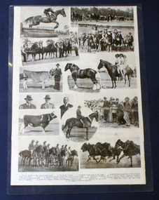
Samuel Lynn (1865-1949) was a farmer and grazier at Jarrahmond. He bred Clydesdales. The 13th Light Horse Regiment was formed at Broadmeadows in Victoria in March 1915; it was the third light horse regiment to have been raised in that state. Its regimental number quickly led to it becoming known as the "Devil's Own" regiment. It left Australia on 28 May and disembarked in Egypt on 29 June 1915. Horses have always been an important part of Orbost's history.A laminated set of photographs on cardboard. it is an arrangement of black / white photocopies posibly for a magazine or display. The photos are of local horses, local people and include Mr S. Lynn, A. Mosely and Orbost No 2 troop 13th Light Horse.photographs-horses lynn-samuel mosely 13th-light-horse -
 Orbost & District Historical Society
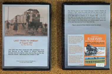
D.V.D. s, Last Train to Orbost, 21.8.1987
These are copies of an original video shot by Ray Barling on the day that the Orbost-Bairnsdale line closed in 1987. He used a hand-held video camera from his cabin on the train, The video was shown at the 2016 Centenary Exhibition in Orbost. The Bairnsdale-Orbost railway was opened in 1916 to serve the agricultural and timber industry. Because of the decline in traffic and heavy operating costs, the line was finally closed in August, 1987. Orbost Railway Station was opened on Monday 10 April 1916 as the terminus of the Orbost railway line, and closed in 1987. The station was located on the west side of the Snowy River despite the town of Orbost being on the east side of the river, in order to save on the costs of a bridge over the river, which at the time had highly variable levels. This item is associated with the history of the Orbost-Bairnsdale railway line and therefore reflects the role that the rail line played in the social and economic history of Orbost. On April 10 1916, the first scheduled train service left Orbost for Bairnsdale. The Bairnsdale-Orbost railway was opened to serve the agricultural and timber industry. Because of the decline in traffic and heavy operating costs, the line was finally closed in August, 1987. Orbost Railway Station was opened on Monday 10 April 1916 as the terminus of the Orbost railway line, and closed in 1987. The station was located on the west side of the Snowy River despite the town of Orbost being on the east side of the river, in order to save on the costs of a bridge over the river, which at the time had highly variable levels, The video was shown for the first time at the Centenary Exhibition held in Orbost, by the Orbost & District Historical Society, t created much interest leading to the production of the videos.Two copies of a D.V.D. titled"Last Train To Orbost 21 August 1987". The cover is a photo of the last train.rail-closure orbost-bairnsdale-railway -
 Orbost & District Historical Society
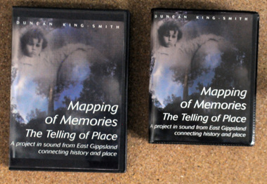
discs and tapes, Mapping of Memories The Telling of Place, 1991-1993
These stories are from the Orbost district, Snowy River flats, Conran, Bete Bolong, Marlo, Bonang, Goongerah, Combienbar, Club Terrace,Cann Valley, Cabanandra, Bendoc, Deddickand McKillop's Bridge' Mapping of Memories was first broadcast as four programs on A.B.C. Radio National in 1993.This item is a record of the lives and history associated with East Gippsland. It is a useful reference tool.Two copies of a D.V.D. titled, "Mapping of Memories The Telling of Place". There are also two tapes - 4 sides. The D.V.D.'s are in black plastic cases with 2 discs in each. The front cover has a colored photo of a child next to a giant pumpkin.memories-orbost-district mapping-of-memories