Showing 3226 items
matching road maps
-
 Greensborough Historical Society
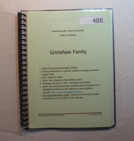
Folder, Grimshaw Family, 1849o
Passenger indexes; maps; mortgage document 1873 Grimshaw and Britnell; history of Aaron and Joshua Grimshaw; Greensborough murder: transcript of the trial of Josiah Grimshaw for the murder of John Mitchell.History of the origins of this Greensborough family.20-page plastic binder, spiral bound, clear cover. Contains documents relating to the Grimshaw family.Collected by Greensborough Historical Society. Folder commenced 2012.grimshaw family -
 Greensborough Historical Society
Folder, Black Family - Greensborough, 1900o
Contents: Family tree; small school books from family member; copy of map and advertisement for Watsonia Electric Station Estate; receipts; cemetery information; article on James Black and descendants; copies of un-named photos taken on Bundoora farm.The Black family owned a large portion of land from Greensborough to Watsonia. This collection is partly from family members.20-page plastic binder, green cover. Contains documents relating to the Black family of Greensborough and Watsonia.Collected by Greensborough Historical Society. Folder commenced 2012black family, shirley fraser, james black, watsonia electric station estate -
 Greensborough Historical Society
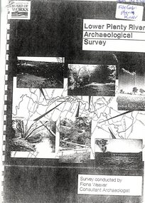
Report, Lower Plenty River Archaeological Survey; Fiona Weaver, 1989_
Archaeological survey of the Lower Plenty River undertaken in 1989-1990 by Fiona Weaver for the Board of Works. Indigenous heritage sites along the Plenty River are examined and recommendations made for the preservation and to lessen the impact of development on these sites.Printed on white A4 paper. Approx 92 pages (not numbered). Illus., maps. 2 copies.plenty river, board of works, aboriginal heritage sites -
 Greensborough Historical Society
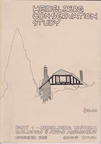
Book, Heidelberg Conservation Study: Part 1 Historic Buildings and Areas Assessment, 1985_
Report prepared by Graeme Butler on behalf of City of Heidelberg and Heidelberg Heritage Advisory Committee. Area covered is from Eaglemont in the south to Macleod in the north.This study identifies neighbourhood character, documents past development and the capacity of the environment for future development.Part one of set of three books. Paperback, 189 pages, Illus., maps. 2 copies.Stamps: Yarra Plenty Regional Library Service, and, Withdrawnheidelberg, macleod, heidelberg heritage advisory committee, graeme butler, plenty river, eaglemont -
 Greensborough Historical Society
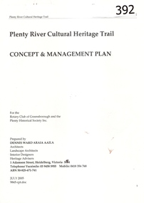
Report, Plenty River Cultural Heritage Trail : Concept & management plan, 2005_07
Prepared for the Rotary Club of Greensborough and Plenty Historical Society by Dennis Ward, this report outlines the heritage importance of the Plenty River Trail around Greensborough.This is an ongoing project by Dennis Ward. This report is an early version of the 2011 Squatters, speculators and settlers: Plenty River Cultural heritage trail. (Item 258) 66 page report, Illus, (some col.) , maps. In red 2-ring binder.Some handwritten notes in last pages.plenty river cultural heritage trail, dennis ward, rotary club of greensborough, plenty historical society, plenty river -
 Greensborough Historical Society
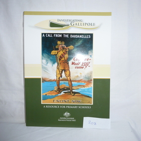
Book and CD, Australia. Department of Veterans Affairs, Investigating Gallipoli : a resource for secondary schools, 2010
Educational worksheets and activities used to teach children about Australia's role in the Gallipoli Campaign.Book: 80 p., illus. (some col.), maps, worksheets. Includes 2 discs: Disc 1 (video) Australians at War Episode 2; Disc 2 (DVD-ROM) Interactive activities and ABCs Gallipoli: the First Day website.australia department of veterans affairs, gallipoli, world war i, educational aids -
 Greensborough Historical Society
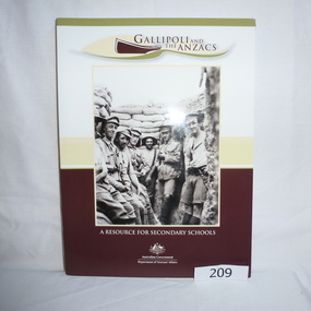
Book - Book and CD, Australia. Department of Veterans Affairs, Gallipoli and the ANZACS : a resource for secondary schools, 2010_
Educational worksheets and activities used to teach children about Australia's role in the Gallipoli Campaign.Book: 120 p., illus. (some col.), maps, worksheets. Includes 2 discs: Disc 1 (video) Australians at War Episode 2 and, Revealing Gallipoli; Disc 2 (DVD-ROM) Interactive activities and ABCs Gallipoli: the First Day website.australia department of veterans affairs, gallipoli, world war i, educational aids -
 Greensborough Historical Society
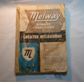
Book, Melway Street Directory of Greater Melbourne. Edition 1, 1966_
The first edition of this iconic Melbourne street directory published in 1966. The directory is accompanied by an outline of the history of the concept and publication of Melway.A surviving first edition of the Melway is rare as these directories are designed to be updated each year. Of interest in this edition is maps of the Greensborough area before large scale subdivision of the land in the late 1960s and 1970s.Soft cover street directory. Coloured maps.189 pages.melway, street directories, melbourne. -
 Halls Gap & Grampians Historical Society
Map - Photocopy
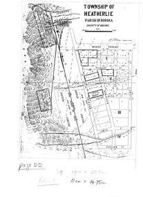
... 117-119 Grampians Road Halls Gap grampians MAPS Heatherlie ...Photocopy of map of Heatherlie TownshipTownship of Heatherlie; Parish of Boroka; County of Borung; scale measurement; R.O. Robson Authorised Surveyormaps, heatherlie township -
 Halls Gap & Grampians Historical Society
Map - Coloured
... 117-119 Grampians Road Halls Gap grampians MAPS Heatherlie ...Map showing layout for township of HeatherlieTownship of Heatherlie; Parish of Boroka; County of Borung; scale measurement; R.O. Robson Authorised surveyormaps, heatherlie township -
 Halls Gap & Grampians Historical Society
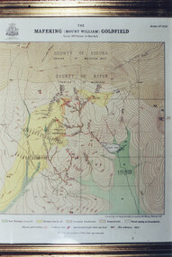
Photograph - Coloured, C 1900
Colour photo of framed map of Mafeking Goldfield.mining, mafeking, maps -
 Halls Gap & Grampians Historical Society
Map - Coloured
... Map of Mt Victory Road and others.... ACCESS ROUTES Mt Victory Rd Bridle Path Roads Map of Mt Victory ...Background on Bridle Path up Stony Creek Gorge Pre 1840 C. B. Hall, squatter on Mokepilly Run 1841-1842, first European to discover the Fyans Creek valley, the entrance of which became known as Hall's Gap. He later recorded that he followed a number of tracks which he assumed had been made by the Aboriginies and described one as "leading up a wild romantic glen and over on to the source of the Glenelg River". This could well have been the route taken up Stony Creek gorge by the first timber-cutters in this part of the Grampians to the saddle between the Wonderland and Mt. Difficult ranges known as Valley Gap 1850s/60s Timber cutters and shingle splitters were reported to be moving into the eastern side of the Grampians and by the mid 1860s there were a number of families connected to the supplying of timber to Pleasant Creek living in the "Hall's Gap ranges". John Wakeham, the first store owner in Pleasant Creek in 1854, established a timer-mill in upper Stony Creek Gorge in the late 1850s. Wakeham is credited for the clearing and levelling of the first bridle-path up the gorge. 1870s By the mid 1870s the track had been extended over Valley Gap to the Victoria Forest (the upper region of the Victoria Valley). McKeon's bullock team was known to have hauled red gum from the Valley to Stawell in the late 1870s and the 1880s. 1880s In 1887 an article in the Pleasant Creek news describes the Stony Creek Gorge track as "being a ledge alongside the mountain range, formed in the early days with the aid of earth and timber, along which the bullock teams used to travel to Horsham and plains of the Wimmera beyond." 1890s Gold was discovered in the catchment area of Stony Creek and by the end of the 1890s a new track was built from "near the junction of Fyan's and Stony Creeks, up the gorge to the diggings settlement. The mining Department had paid L300 for its construction and, when completed, the track was "three miles and 30 chains in length, the side cuttings at the narrowest part being 10 feet between" and "the watercourses which cross the track at various points" having been "filled up with rocks rolled down the sides of the hills, and consequently there can be no damage caused by bushfires which destroyed the former wooden bridges erected on the old track to Wakeham's saw-mill, the remains of which are still to be seen at the side of the diggings" The article goes on to further describe the track as one which "can with ease travel with a two horse conveyance either up or down" and that the workmen engaged in the construction of the track would be attending "a ball that night at McKeon's farm near the mouth of the gap to celebrate the successful completion of the undertaking". 1900s At what time the bridle path was extended beyond Valley Gap to the Wartook basin on the Mt. Difficult Range has not yet been determined. However, it is known that, by the turn of the century, people were travelling between Halls Gap and the caretakers' residence at Wartook Reservoir along what was now known as the "Bluff Road. Wartook's embankment had been constructed in 1887 and at that time there was already a track from Rosebrook Station homestead (near the present day Wartook Pottery) to the reservoir. Philip Rose owned both Rosebrook and Wartook Stations from the mid 1840s to the late 1850s and had regularly leased the Wartook basin to Cobb & Co. to rest horses there. 1920s Following the war of 1914-1918, tourism really took off in the Grampians, and Halls Gap rapidly grew. People would travel as far as they could on the many tracks then hike to the many lookouts being discovered by local tour guides. This led to the need for access across the range so that horse riders and the increasing number of vehicles could travel between Horsham and Halls Gap. To this end, the Bluff Road was improved and extended on 1929 and at its opening in March, 1930, by Lady Somers it was renamed the Mt. Victory Road.Map of Mt Victory Road and othersaccess routes, mt victory rd, bridle path, roads -
 Halls Gap & Grampians Historical Society
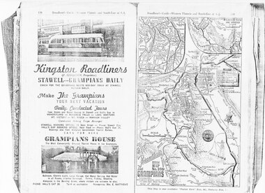
Magazine - Photocopy
Kingston Roadliners (F. Kingston, Proprietor) STAWELL - GRAMPIANS DAILY Coach for the Grampians meets mid day train at Stawell Return Daily Make the Grampians your next vacation Daily Conducted Tours, from Hotels and Guesthouses in Stawell and Hall's Gap to WONDERLAND - MCKENZIE FALLS - LAKE WARTOOK - MT. VICTORY - MT ROSEA - WANNON VALLEY conducted Hiking Trips Arranged Stawell booking office: 75 Main Street - Phone: Stawell 214, Hall's Gap booking office: Main Road - Phone: Hall's Gap 35, Bookings also from Vitorian Government Tourist Bureau, Cars for hire GRAMPIANS HOUSE The Most Conveniently Situated Tourist House in the Grampians. Ballroom, electric light, large garage, hot water service, hot water in all rooms, internal sewerage. Tennis, fishing, shooting, Alongside is the Bowling Green, where visitors are welcome to play. Phone: Hall's Gap 28. Tariff on application. Manageress: Mrs, E. MatthewsAdvertisement for Kingston Roadliners, Grampians House and Map of the GrampiansAdvertisement in Broadbents, Guide of western Victoria, and South-East of S.A.media, advertisements, grampian house -
 Greensborough Historical Society
Pamphlet - Advertising pamphlet, Valley Central Greensborough, 1980s
Early advertising and list of tenants for Valley Central, now known as Greensborough Plaza. Gloss colour pamphlet and black and white mapgreensborough shopping centre, greensborough plaza, valley central -
 Greensborough Historical Society
Card - Advertising Card, Diamond Valley Community, Greensborough Community Market 2008, 2008
Advertising Card about the Greensborough Community Market moving to La Trobe University in 2008. This market is managed by Diamond Valley Community Support.Coloured Advertising Card - 2 sided with mapmarkets, greensborough community market, diamond valley community support -
 Greensborough Historical Society
Pamphlet, Lower Plenty Shopping Centre, 2007
Coloured pamphlet from Lower Plenty Shopping Centre with list of shops, map and 2008 CalendarColour pamphlet with calendar and maplower plenty shopping centre, calendars, lower plenty -
 Halls Gap & Grampians Historical Society
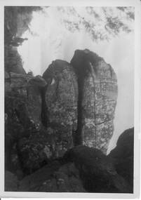
Photograph - B/W, C 1940s -- 50s
Rock formation is called " The Woolpacks " and was located on the Wonderland Track at the top of Silent Street -- however on a Broadbent map of the Grampians no.205 this formation was called the " Wool Sacks " ; and the "Woolpacks" was shown on the map close to Venus Bath.Photo shows distinct slabs of rock balancing on each other. Three people appear in the photo -- a man with a boy and a woman. All three are wearing hats. A large rock outcrop can be seen on right of photos -- trees can be seen on left.The Wool Packs F5030scenery, wonderland range -
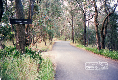 Eltham District Historical Society Inc
Photograph, Ardean Park, 315 Flat Rock Rd, Hurstbridge
Sold by Fletchers 3 Dec 2015 for $1.26m. See https://www.realestate.com.au/sold/property-house-vic-hurstbridge-121193850 Google Streetview Feb 2014 https://www.google.com.au/maps/@-37.6455525,145.2071828,3a,49.4y,333.82h,88.64t/data=!3m6!1e1!3m4!1sr2PfMo3UeXV_fqSDYToiuA!2e0!7i13312!8i6656Roll of 35mm colour negative film, 2 stripsKodak GA 100 5095shire of eltham, roads, flatrock road, hurstbridge, ardean park, cowan -
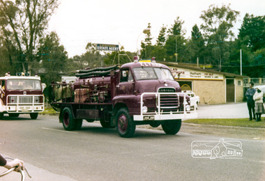 Eltham District Historical Society Inc
Photograph, Eltham Fire Brigade, Eltham Community Festival Parade, Main Road opposite Wingrove Park, 4 August 1978, 04/08/1978
Eltham Community Festival, 4-13 August 1978 Newsletter No. 3 September 1978 Eltham Community Festival. This year’s Eltham Community Festival was held from August 4th to 13th. The society was involved with the Warrandyte Historical Society in arranging an exhibition at the Community Centre and also provided notes and a map for a self-guided walking tour of historic buildings and locations around Eltham. Copies of notes will continue to be available from the Eltham Shire Offices and the tour may be under-taken at any time. The exhibition was divided into two sections. The Eltham Society displayed early photographs associated with the walking tour, whilst the Warrandyte Society showed their photographs and artefacts of the Warrandyte gold era. An outstanding feature was the large "blow-up" photos of early Warrandyte. Colour photographeltham, main road, eltham festival, alan whitmore estate agents, shell service station, mount pleasant road, parade, parade float, wingrove park, fire brigrade -
 Eltham District Historical Society Inc
Photograph, 2nd Eltham Sea Scouts, Eltham Parade, Main Road opposite Wingrove Park, August 1978, 04/08/1978
Eltham Community Festival, 4-13 August 1978 Newsletter No. 3 September 1978 Eltham Community Festival. This year’s Eltham Community Festival was held from August 4th to 13th. The society was involved with the Warrandyte Historical Society in arranging an exhibition at the Community Centre and also provided notes and a map for a self-guided walking tour of historic buildings and locations around Eltham. Copies of notes will continue to be available from the Eltham Shire Offices and the tour may be under-taken at any time. The exhibition was divided into two sections. The Eltham Society displayed early photographs associated with the walking tour, whilst the Warrandyte Society showed their photographs and artefacts of the Warrandyte gold era. An outstanding feature was the large "blow-up" photos of early Warrandyte. Two colour photographseltham, main road, eltham festival, alan whitmore estate agents, shell service station, mount pleasant road, parade, parade float, wingrove park, 2nd eltham sea scouts -
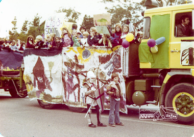 Eltham District Historical Society Inc
Photograph, Our Lady's School, Eltham Community Festival Parade, Main Road opposite Wingrove Park, 4 August 1978, 04/08/1978
Eltham Community Festival, 4-13 August 1978 Newsletter No. 3 September 1978 Eltham Community Festival. This year’s Eltham Community Festival was held from August 4th to 13th. The society was involved with the Warrandyte Historical Society in arranging an exhibition at the Community Centre and also provided notes and a map for a self-guided walking tour of historic buildings and locations around Eltham. Copies of notes will continue to be available from the Eltham Shire Offices and the tour may be under-taken at any time. The exhibition was divided into two sections. The Eltham Society displayed early photographs associated with the walking tour, whilst the Warrandyte Society showed their photographs and artefacts of the Warrandyte gold era. An outstanding feature was the large "blow-up" photos of early Warrandyte. Colour photographeltham, main road, eltham festival, alan whitmore estate agents, shell service station, mount pleasant road, parade, parade float, wingrove park, our ladys school -
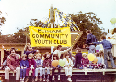 Eltham District Historical Society Inc
Photograph, Eltham Community Youth Club, Eltham Community Festival Parade, Main Road opposite Wingrove Park, 4 August 1978, 04/08/1978
Eltham Community Festival, 4-13 August 1978 Newsletter No. 3 September 1978 Eltham Community Festival. This year’s Eltham Community Festival was held from August 4th to 13th. The society was involved with the Warrandyte Historical Society in arranging an exhibition at the Community Centre and also provided notes and a map for a self-guided walking tour of historic buildings and locations around Eltham. Copies of notes will continue to be available from the Eltham Shire Offices and the tour may be under-taken at any time. The exhibition was divided into two sections. The Eltham Society displayed early photographs associated with the walking tour, whilst the Warrandyte Society showed their photographs and artefacts of the Warrandyte gold era. An outstanding feature was the large "blow-up" photos of early Warrandyte. Colour photographeltham, main road, eltham festival, alan whitmore estate agents, shell service station, mount pleasant road, parade, parade float, wingrove park -
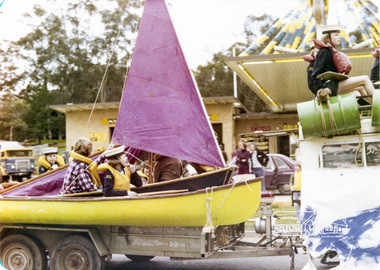
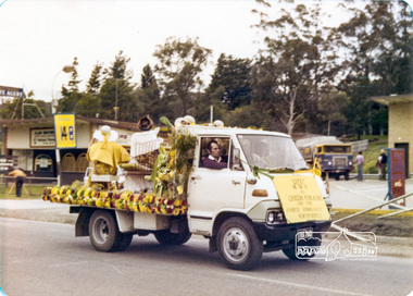
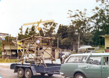
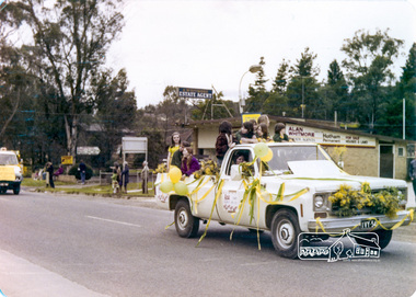 Eltham District Historical Society Inc
Photograph, Eltham Community Festival Parade, Main Road opposite Wingrove Park, 4 August 1978, 04/08/1978
Eltham Community Festival, 4-13 August 1978 Newsletter No. 3 September 1978 Eltham Community Festival. This year’s Eltham Community Festival was held from August 4th to 13th. The society was involved with the Warrandyte Historical Society in arranging an exhibition at the Community Centre and also provided notes and a map for a self-guided walking tour of historic buildings and locations around Eltham. Copies of notes will continue to be available from the Eltham Shire Offices and the tour may be under-taken at any time. The exhibition was divided into two sections. The Eltham Society displayed early photographs associated with the walking tour, whilst the Warrandyte Society showed their photographs and artefacts of the Warrandyte gold era. An outstanding feature was the large "blow-up" photos of early Warrandyte. Colour photographeltham, main road, eltham festival, alan whitmore estate agents, shell service station, mount pleasant road, parade, parade float, wingrove park -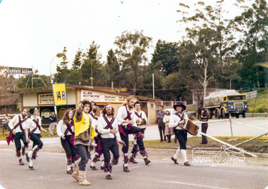
 Eltham District Historical Society Inc
Photograph, Country Womens Association Montmorency, Eltham Community Festival Parade, Main Road opposite Wingrove Park, 4 August 1978, 04/08/1978
Eltham Community Festival, 4-13 August 1978 Second photo of 5 ladies very motion blurred but ladies named are L to R: Edi Levi, Joyce Finster, Thelma Smith, Jean Spencer, Norma Williams. Newsletter No. 3 September 1978 Eltham Community Festival. This year’s Eltham Community Festival was held from August 4th to 13th. The society was involved with the Warrandyte Historical Society in arranging an exhibition at the Community Centre and also provided notes and a map for a self-guided walking tour of historic buildings and locations around Eltham. Copies of notes will continue to be available from the Eltham Shire Offices and the tour may be under-taken at any time. The exhibition was divided into two sections. The Eltham Society displayed early photographs associated with the walking tour, whilst the Warrandyte Society showed their photographs and artefacts of the Warrandyte gold era. An outstanding feature was the large "blow-up" photos of early Warrandyte. Two colour photographs (one very blurry but with members names on it)eltham, main road, eltham festival, alan whitmore estate agents, shell service station, mount pleasant road, parade, parade float, wingrove park, country women's association, montmorency, edi levi, joyce finster, thelma smith, jean spencer, norma williams -
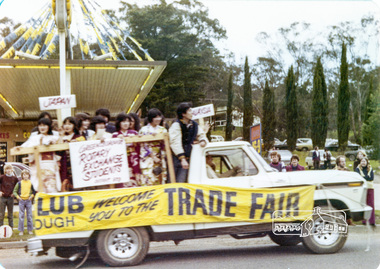 Eltham District Historical Society Inc
Photograph, Rotary Exchange Students, Eltham Community Festival Parade, Main Road opposite Wingrove Park, 4 August 1978, 04/08/1978
Eltham Community Festival, 4-13 August 1978 Second photo of 5 ladies very motion blurred but ladies named are L to R: Edi Levi, Joyce Finster, Thelma Smith, Jean Spencer, Norma Williams. Newsletter No. 3 September 1978 Eltham Community Festival. This year’s Eltham Community Festival was held from August 4th to 13th. The society was involved with the Warrandyte Historical Society in arranging an exhibition at the Community Centre and also provided notes and a map for a self-guided walking tour of historic buildings and locations around Eltham. Copies of notes will continue to be available from the Eltham Shire Offices and the tour may be under-taken at any time. The exhibition was divided into two sections. The Eltham Society displayed early photographs associated with the walking tour, whilst the Warrandyte Society showed their photographs and artefacts of the Warrandyte gold era. An outstanding feature was the large "blow-up" photos of early Warrandyte. Colour photographeltham, main road, eltham festival, alan whitmore estate agents, shell service station, mount pleasant road, parade, parade float, wingrove park, rotary -
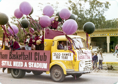 Eltham District Historical Society Inc
Photograph, Eltham Basketball Club, Eltham Community Festival Parade, Main Road opposite Wingrove Park, 4 August 1978, 04/08/1978
Eltham Community Festival, 4-13 August 1978 Newsletter No. 3 September 1978 Eltham Community Festival. This year’s Eltham Community Festival was held from August 4th to 13th. The society was involved with the Warrandyte Historical Society in arranging an exhibition at the Community Centre and also provided notes and a map for a self-guided walking tour of historic buildings and locations around Eltham. Copies of notes will continue to be available from the Eltham Shire Offices and the tour may be under-taken at any time. The exhibition was divided into two sections. The Eltham Society displayed early photographs associated with the walking tour, whilst the Warrandyte Society showed their photographs and artefacts of the Warrandyte gold era. An outstanding feature was the large "blow-up" photos of early Warrandyte. Colour photographeltham, main road, eltham festival, alan whitmore estate agents, shell service station, mount pleasant road, parade, parade float, wingrove park, eltham basketball club -
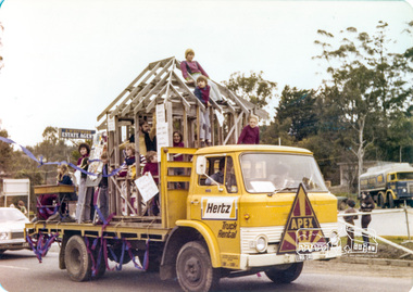 Eltham District Historical Society Inc
Photograph, Apex, Eltham Parade, Eltham Community Festival Parade, Main Road opposite Wingrove Park, 4 August 1978, 04/08/1978
Eltham Community Festival, 4-13 August 1978 Newsletter No. 3 September 1978 Eltham Community Festival. This year’s Eltham Community Festival was held from August 4th to 13th. The society was involved with the Warrandyte Historical Society in arranging an exhibition at the Community Centre and also provided notes and a map for a self-guided walking tour of historic buildings and locations around Eltham. Copies of notes will continue to be available from the Eltham Shire Offices and the tour may be under-taken at any time. The exhibition was divided into two sections. The Eltham Society displayed early photographs associated with the walking tour, whilst the Warrandyte Society showed their photographs and artefacts of the Warrandyte gold era. An outstanding feature was the large "blow-up" photos of early Warrandyte. Colour photographeltham, main road, eltham festival, alan whitmore estate agents, shell service station, mount pleasant road, parade, parade float, wingrove park, apex -
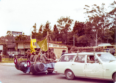 Eltham District Historical Society Inc
Photograph, !st Eltham Scouts and Cubs, Eltham Community Festival Parade, Main Road opposite Wingrove Park, 4 August 1978, 04/08/1978
Eltham Community Festival, 4-13 August 1978 Newsletter No. 3 September 1978 Eltham Community Festival. This year’s Eltham Community Festival was held from August 4th to 13th. The society was involved with the Warrandyte Historical Society in arranging an exhibition at the Community Centre and also provided notes and a map for a self-guided walking tour of historic buildings and locations around Eltham. Copies of notes will continue to be available from the Eltham Shire Offices and the tour may be under-taken at any time. The exhibition was divided into two sections. The Eltham Society displayed early photographs associated with the walking tour, whilst the Warrandyte Society showed their photographs and artefacts of the Warrandyte gold era. An outstanding feature was the large "blow-up" photos of early Warrandyte. Colour photographeltham, main road, eltham festival, alan whitmore estate agents, shell service station, mount pleasant road, parade, parade float, wingrove park, !st eltham scouts -
 Eltham District Historical Society Inc
Photograph, Montmorency Scouts, Eltham Community Festival Parade, Main Road opposite Wingrove Park, 4 August 1978, 04/08/1978
Eltham Community Festival, 4-13 August 1978 Newsletter No. 3 September 1978 Eltham Community Festival. This year’s Eltham Community Festival was held from August 4th to 13th. The society was involved with the Warrandyte Historical Society in arranging an exhibition at the Community Centre and also provided notes and a map for a self-guided walking tour of historic buildings and locations around Eltham. Copies of notes will continue to be available from the Eltham Shire Offices and the tour may be under-taken at any time. The exhibition was divided into two sections. The Eltham Society displayed early photographs associated with the walking tour, whilst the Warrandyte Society showed their photographs and artefacts of the Warrandyte gold era. An outstanding feature was the large "blow-up" photos of early Warrandyte. Colour photographeltham, main road, eltham festival, alan whitmore estate agents, shell service station, mount pleasant road, parade, parade float, wingrove park