Showing 10796 items
matching sites
-
 Melton City Libraries
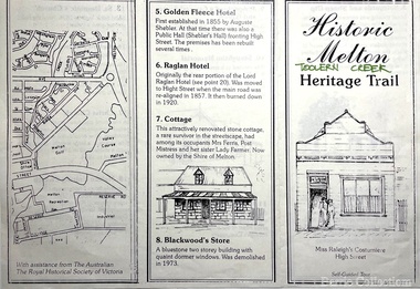
Pamphlet, Historic Melton Toolern Vale Heritage Trail, Unknown
Tour of historic sites in Melton including Melton State School 430 and Uniting Churchlandscapes of significance, local architecture -
 Melton City Libraries
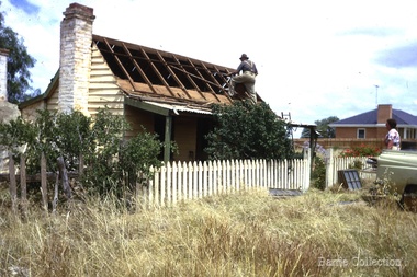
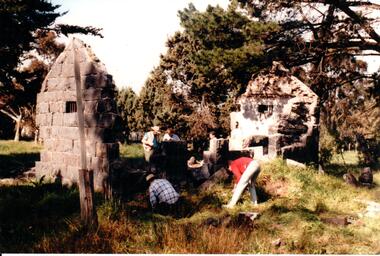
Photograph, Ned Toohey's house, McKenzie Street, 1970
Cottage of Edward Toohey (died 1898) a Shire contractor and road maker. Ned, his son worked with Frederick Myers building many of the bluestone roads in the Shire of Melton. In the background is the brick house built for Martha Myers in 1967. Martha and husband Frederick (born 1877 in Melton) resided in the Myers (Miers) house on Western Highway beside the gully near Reserve road. Frederick lived there for 86 years. The house was built in 1867 by Henri and Ann nee Dowling Myers. Demolished 1968. Martha Myers house was demolished in 2011 to become a car park. Mary and Jack Tolhurst removing roof of Ned Tooheys house (site of Senior Citizens ).local identities, misc. -
 Stawell Historical Society Inc
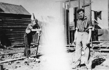
Photograph, Building Salvation Army Citadel 1934
B/W. Photograph of two men on Construction site one with crowbar other with tape.Work on Citadel - Shifting the Old Hall 1934 Don Reeve on Rightreligion -
 Bendigo Historical Society Inc.
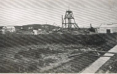
Photograph - MINING SITE
As there is no information re this Photo it would appear to be that it could be a mining site being erected or dismantled.mining, surface equipment, surface site, mining site. -
 Federation University Historical Collection
Photograph, E.J. Barker, Institutional Real Estate, 2007
Draft chapter written by E.J. Barker describing the purchase and development of the Mount Helen Site.mount helen campus, e.j. barker, jack barker, history -
Bendigo Historical Society Inc.
Map - MAP WHITE HILL TO HUNTLY
Map of Bendigo creek and adjacent leads - White Hills to Huntly replotted from old 4 chain to 1 inch survey of 1860 by G. W. Hart - Surveyor. Base of roads and streets taken from D.L.S. 1 . 10000 base maps. Legend: battery site, puddling mill site, dam bank site, cutting altering course of creek, lead boundaries.bendigo, mining -
 Bendigo Historical Society Inc.
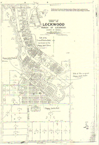
Map - LONG GULLY HISTORY GROUP COLLECTION: LOCKWOOD TOWNSHIP
Copy of a map of Township of Lockwood, County of Bendigo. Printed at the top of the map is: Parish map of Lockwood showing location of Happy Jack's paddock & hut and the sites of the Crown & Anchor Hotel and the original Happy Jack Hotel. Written on the map with arrows pointing to the site is: Happy Jack's Paddock, Site of the original Happy Jack Hotel and Happy Jack's Hut. An outline of Happy Jack's Paddock is drawn in.bendigo, history, long gully history group, the long gully history group - lockwood township, crown & anchor hotel, happy jack hotel, happy jack store, county of bendigo -
 The Beechworth Burke Museum
Photograph, 1910
This photograph dating to 1910 depicts an open cut sluicing site located in El Dorado captured looking east up the open cut from the number 3 Barge site. Sluicing was undertaken in the area from 1900 to 1942 with some short breaks between these periods. The image depicts a location mined by Cocks Pioneer Gold and Tin Sluicing Company (as recorded on the annotation on the card mount). It portrays open cut rocks with a crevice in the center of the image where the sluicing was being undertaken. There is a small timber structure on the right of the image which could be an entrance to a mine or supports made of wood to prevent a cave in at the open cut site and above the cut rock there is bush. The timber structure has rail tracks on top of the bridge which could suggest the identification of this structure as a mine entrance. The rail tracks were used for little carts which hauled soil from the mine. The Cocks Pioneer Gold and Tin Mines N.L was one of El Dorado's two largest open cut sluicing mines of the 20th Century. The other was named the Cocks El Dorado Gold Dredging Company. The Cocks Pioneer Mines operated from 1901 until 1941 and found a total of 117,378 ounces of Gold and 1,673 tones of tin concentrates over these years. The Cocks company was formed in 1898 and operated until 1941. Open cut sluicing involved the use of high-powered hoses which used the centrifugal sand pump system (known as hydraulic sluicing) which broke down the soil which was then processed for gold and other precious metals. From 1914 , four years after this image was captured, the company reformed to Cocks Pioneer Gold and Tin Mines NL (previously it was known as Cocks Pioneer Sluicing Co) and undertook large scale sluicing operations until 1929 and then 1934-1941. El Dorado is located on Reedy Creek and is surrounded by forested country to the north and east. It is 20 km east of Wangaratta in Victoria's regional north-east. John Cock was the son of a Cornish minor who arrived in El Dorado in 1858. Cock founded his gold and tin mining company which ran successfully for many years in the El Dorado region. It was an open cut sluicing company because of the abandonment of underground mining after this was deemed too dangerous. In 1935 Cock's El Dorado Company commissioned the floating dredge which is still visible in El Dorado today. The dredge was built by the Thompson engineering works, Castlemaine, and weighed over 2,000 tones and today has a place on the Victorian Registers of historic buildings. Interestingly, the name El Dorado does not derive from the gold in the region, but from the Barambogie pastoral run completed by William Baker in 1840-1841. Gold was discovered in El Dorado 1854 but the gold was too deep for individual prospectors to find, it required the use of heavy machinery.The search for gold is ingrained into the history of Victoria and therefore, images like this one which portray an open cut sluicing site can reveal important information for society and technology for the date when the photograph was taken. This image is of important historical significance for its ability to convey information about sluicing and the methods used to find gold in 1910. It also shows a location where sluicing was undertook which provides insight into the impact of sluicing on the environment at a time when it was done. This image is important for current research into the history of El Dorado, a small regional location near Wangaratta in Victoria's North East. Therefore, this image has the capacity to be beneficial for research into society and the motivations of those living and working in this region during this period and therefore, has social significance. The Beechworth Burke Museum has additional images relating to gold sluicing and El Dorado which can be analysed and studied alongside images like this one.Sepia coloured rectangular photograph printed on gloss photographic paper mounted on board.Obverse: COCKS PIONEER Q + T SL CO, N.L. / 1910 / LOOKING EAST UP OPEN CUT / FROM NO3 BARGE SITE / Reverse: 1997 . 2611 / A02611el dorado, north east gold, sluicing, gold sluicing, hydraulic sluicing, 1910, gold and tin mine, open cut mining, mining, gold mining, north-east victoria, beechworth, burke museum -
 Ringwood and District Historical Society
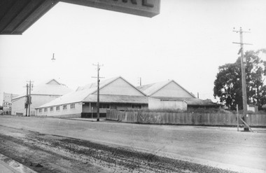
Photograph, Ringwood Cool Stores Corner Main St. and Wantirna Rd1958
Black and white photograph of Ringwood Cool Stores. Photographs shows wooden buildings with gently sloping peaked corrugated iron roofing. Picket fence at front of building with "Vote NO" painted.Typed below photograph, "Ringwood Cool Stores. Present site of Ringwood Clock Tower, 1958". Written on backing sheet, "Cool Store 1958. Corner Main St. and Wantirna Rd. Now site of Clock Tower". -
 Ringwood and District Historical Society
Photographs, Demolition of the Ringwood Mail premises in Maroondah Highway, 2011
Collection of three Ringwood photographs:; 1. Demolition of Ringwood Mail premises - note the Ringwood Mail sign.; 2. Demolition site - note the 'Award Winning Dealership' sign.; 3. Demolition site - note the 'Award Winning Dealership' sign. -
 Bendigo Historical Society Inc.
Slide - RALPH BIRRELL COLLECTION: EIG SCHOOL, c1966
EIG School - Ralph Birrell Collection. - Construction of Latrobe Uni. C1966. Bendigo Institute of Technology, Engineering School, Applied Science. Cow grazing on site or nearby site. Gives a good idea of what the land was used for prior to construction.Kodakeducation, tertiary, latrobe university bendigo, eig school - ralph birrell collection. - construction of latrobe uni. c1966. bendigo institute of technology, engineering school, applied science. cow grazing on site. idea of what the land was used -
Port Melbourne Historical & Preservation Society
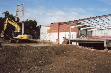
Photograph - Former Faram Bros store, Bay Street, Port Melbourne, David Thompson, 6 Feb 2011
Photographs were taken on 6 February 2011Set of six colour photographs of former Faram Bros Hardware store site, 405 -415 Bay St. Photographs show retained facade from the street and aslo from inside the site during demolition works february 2011bay street, business and traders - hardware, built environment - commercial, faram brothers hardware -
 Warrnambool and District Historical Society Inc.
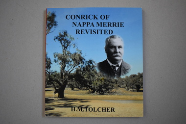
Book - Conrick of Nappa Merrie Revisited
This book is a 2015 transcription of a 1995 book by Helen Tolcher. It contains the story of the establishment in the 1870s of the Nappa Merrie station on the South Australian- Queensland border on the Coopers Creek. The station was established by John Conrick after he and three other men set off with 1600 cattle in 1872 from Koroit in Victoria, arriving at the new property site eleven months later. John Conrick (1852-1926) was the son of Patrick and Ellen Conrick who were farmers in the Tower Hill area. John Conrick had four sons who continued to run Nappa Merrie until family connections to the property ceased in 1960. This book is of interest as a record of the legend-making overland cattle droving feat by Koroit resident, John Conrick and three others in the early 1870s and of the establishment of an important property in Queensland following the overland trip. This is a soft cover book of 132 pages. The cover is multi-coloured with photographs of John Conrick and the Dig Tree site at Coopers Creek. The pages contain a preface, 19 chapters of text and an index. There are several maps and many black and white and colour photographs. conrick family of koroit, nappa merrie property, queensland, warrnambool -
 Orbost & District Historical Society
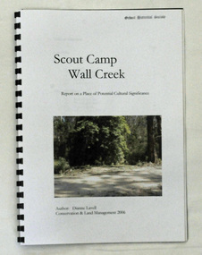
book, Scout Camp Wall Creek, 2006
This report was written by Dianne Lavell for the Department of Conservation and Land Management. Dianne Lavell worked for the Department of Conservation and Land Management in Orbost. She was a long time resident of Orbost. A spiral bound, plastic covered book titled Scout Camp Wall Creek. It is a report on Scout Camp at Wall Creek in Orbost. It contains description and history of the site deemed to be a place of potential cultural significance. on the front cover is a coloured photo of the site.scout-camp-wall-creek -
 Bendigo Historical Society Inc.
Document - NATIONAL TRUST COLLECTION: EAGLEHAWK ON FOOT
Three pages of handwritten notes of a walking tour of Eaglehawk titled Eaglehawk on foot starting from the Town Hall. Other sites are: Mechanics institute, Cannons, CBC Bank, State Bank, Camp Hotel there are twenty eight sites in all listed.eaglehawk, history, walking tour -
 Bendigo Historical Society Inc.
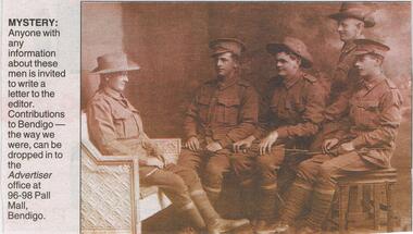
Newspaper - JENNY FOLEY COLLECTION: MISTERY
Bendigo Advertiser ''The way we were" from Monday, December 27, 2004. Mystery: five unknown soldiers, one sited on a couch facing right, three sited on stools facing left and one standing facing left. The clip is in a folder.newspaper, bendigo advertiser, the way we were -
 Hume City Civic Collection
Photograph, c 1993
Aitkens Gap Police Lock up was originally constructed at The Gap which was south of the junction of Gap Road (Sunbury Road) and Calder Highway (Victoria St/Mt. Alexander Road). It was part of a police complex which was a changeover station for the gaol escort. The goal was relocated and rebuilt in the police station grounds in Sunbury in 1993.A coloured photograph of five men working on the removal of Aitkens Gap Gaol from its original site. Two end walls of the gaol are standing and the work is being done on the front and back of the building. Conifers and cypress trees are growing around the site.peter free, aitkens gap gaol, police historical association, sunbury police station, george evans collection -
 Tarnagulla History Archive
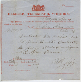
Telegram: Fahy to Dunolly, 21st January 1864
Murray Comrie Collection. A telegram sent from a Bill (?) Fahy in Tarnagulla to a recipient in Dunolly on 21st Jan 1864. Notifies recipient that 'contractors men arrived'. Author says 'i do not know the site. Contractors men leaving material on supposed site near Reservoir'.tarnagulla, post office, telegrams, chief secretary, fahy, construction, reservoir, recreation reserve, workers, work -
 Lakes Entrance Historical Society
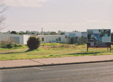
Photograph - Esplanade Lakes Entrance 2000, M Holding, 2000 c
Original building relocated to Mill Point Road Lake Tyers BeachColour photograph of untidy site on Esplanade between Toyworld and hairdressing salon after removal of original building. King and Heath Estate Agents board on site advertising an ambitious development for a residental complex which did not eventuate Lakes Entrance Victoriabusinesses, roads and streets -
 Bendigo Historical Society Inc.
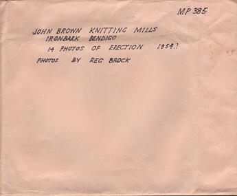
Photograph - HANRO COLLECTION: PHOTOGRAPHS OF THE ERECTION OF JOHN BROWN KNITTING MILLS, 1954
John Brown Industries became a listed company in 1951 and acquired Star Hosiery Mills factory and its Bendigo offshoot. In 1955 they purchased a 4 acre site at Ironbark to build a new mill. This was completed in a record 19and a half weeks and the mill was handed over in Sept. 1956.Photographs of the Erection of John Brown Knitting Mills: A brown envelope which had hand printed writing in black ink. On the right hand top is *MP385*. In the middle *John Brown Knitting Mills Ironbark Bendigo. 14 Photos of Erection 1954? Photos by Reg Brock*. Attached to the envelope is a torn piece so paper which has been hand written in blue ink *John Brown & Welmar* Knitwear Socks & Dress wear The Finest in the Land. Made on the site of Bendigo's Richest Gold Mine, *The Little 180*. Inside the envelope is a collection of black and white photos of the erection of the John Brown Knitting Mills on Marong Road in Ironbark Bendigo. 14 Photos in total showing various views of the construction site. Workmen on the site laying bricks, constructing the steel building and trucks delivering steel etc. A crane truck with *General Carriers Bendigo* printed on the side door. On the back of each photo is *MP385*. The Circular stamp in blue ink of the Royal Historical Society of Victoria Bendigo Branch and a cream photographers label with a blue band top and bottom with *Reg. V. Brock of Bendigo in the bands. In the centre of the label in blue print is *No.... B1098. pos.... Additional copies may be obtained at any time by quoting this number. Box 116A.Reg. V. Brock of Bendigo.photograph, building, john brown, john brown knitting mills -
Federation University Art Collection
Painting - Acrylic on Linen, 'Tingari Cycle' by Walala Tjapaltjarri
Walala Tjapaltjarri (b. c1960) Language: Pintupi Region: Kiwirrkuru In late 1984 Walala Tjapaltjarri and several other members of the Pintupi Tribe walked out of the remote wilderness of the Gibson Desert in Western Australia and made contact for the first time with European society. Described as 'The Lost Tribe', he and his family created international headlines. Until that day in 1984, Walala and his family lived the traditional and nomadic life of a hunter-gatherer society. Their intimate knowledge of the land, its flora and fauna and waterholes allowed them to survive, as their ancestors had for thousands of years. It is this sacred landscape, and its significant sites, that Walala so strikingly describes in his paintings. His style is generally highlighted by a series of rectangles set against a monochrome background. He paints the Tingari Cycle (a series of sacred and secret mythological song cycles) which are associated with the artist's many dreaming sites - they are Wilkinkarra, Maruwa, Tarrku, Njami and Yarrawangu, to name a few. These Dreamings are the locations of significant rockholes, sandhills, sacred mountains and water soakages in the Gibson Desert. (http://www.kateowengallery.com/artists/Wal90/Walala-Tjapaltjarri.htm, accessed 18 May 2015) Walala Tjapaltjarri started painting in 1997. His earliest works were in a classical Tingari style usually reserved for body painting, ground painting and the decoration of traditional artifacts. Within a couple of months his painting had evolved into his own innovative style of work, including the abstraction of classical Pintupi designs which resulted in a highly graphic language to speak of his country and ceremonial sites. The rectangles so prominent in his paintings form both a physical and spiritual map establishing Walala as a discerning draughtsman for his ancient country. (http://www.kateowengallery.com/artists/Wal90/Walala-Tjapaltjarri.htm, accessed 18 May 2015) This item is part of the Federation University Art Collection. The Art Collection features over 1000 works and was listed as a 'Ballarat Treasure' in 2007.Tingari Cycle - During the Tjukurrpa (Creation Era) Tingari ancestors beings gathered at a series of sites for Malliera (Initiation) Ceremonies. They travelled vast stretches of the country, performing rituals at specific sites that in turn created the diverse natural features of the environment. The Tingari men were accompanied by novices and usually followed by Tingari Women. The creation stories and rituals are venerated in the song cycles and ceremonies of today, forming part of the teachings of the post initiatory youths, whilst also providing explanations for contemporary customs. Walala Tjapaltjarri uses a highly personalised and minimal style to represent aspects of the sacred Tingari Cycle, an epic journey of Ancestors of the TJukurrpa (Creation Era). He paints aspects of the Tingari Cycle which are associated with the artist's many sacred sites - such as Wilkinkarra, Maruwa, Tarrku, Njami and Yarrawangu, to name a few. These are locations of significant rockholes, sandhills, sacred mountains and water soakages in the Gibson Desert. (http://www.kateowengallery.com/artists/Wal90/Walala-Tjapaltjarri.htm, accessed 18 May 2015)art, artwork, walala tjapaltjarri, aboriginal, dreaming, creation era, acrylic on linen, pintupi, kiwirrkuru, tingari, wilkinkarra, tarrku, njami, yarrawangu -
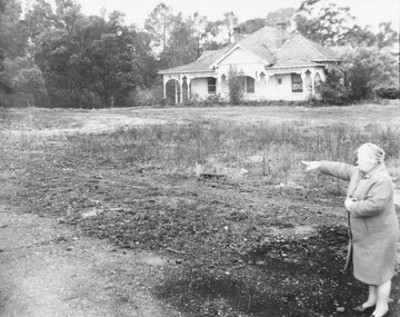 Ringwood and District Historical Society
Photograph, Mrs. E.V. Pullin, Chairman Library Promotion Committee pointing to new library site - 1967 - opposite Eastland and the bowling green, Warrandyte Road. Five photographs
Mrs. E.V. Pullin, Chairman Library Promotion Committee pointing to library site - 1967 - opposite Eastland and the bowling green, Warrandyte Road. House on the library site was demolished at the end of 1968 and the library opened on 2nd May 1970. -
 Ballan Shire Historical Society
Painting, Edward Bonveventure Heffernan, Hanrahans Hotel, 1986
An original watercolour painting surrounded by a white backing under glass in a plain brown timber frame'Present site of Hudsons Hotel'. Edward Heffernan 86 Corner of Inglis and Stead St. 1914 -
 Ringwood and District Historical Society
Photograph, Maroondah Highway Central, Ringwood - Methodist Church & Sunday School, 1914
Black and white photograph/Postcard.Written on back of image: "Methodist Church and Sunday School from site of present church. 1914." -
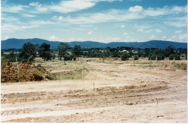
 Ringwood and District Historical Society
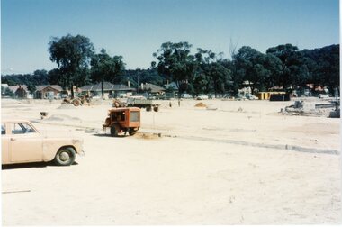
Photograph, New housing estate construction. circa 1960's
Postcard size coloured photograph"Written on back of photograph" Construction of new housing estate -site unknown. circa 1960's -
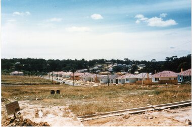 Ringwood and District Historical Society
Photograph, New housing estate construction. circa 1960's
Postcard size coloured photograph"Written on back of photograph" Construction of new housing estate -site unknown. circa 1960's -
 Ringwood and District Historical Society
Photograph, New housing estate construction. circa 1960's
Postcard size coloured photograph"Written on back of photograph" Construction of new housing estate -site unknown. circa 1960's -
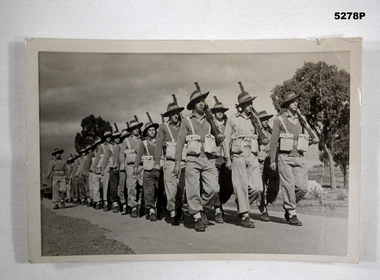 Bendigo Military Museum
Photograph - PHOTOGRAPH, SOLDIERS MARCHING, Bendigo Advertiser - Photographic Service. Photo order NR. DR143
Refer to service of Harry Burrell "MM". See Cats 290, 297.2P, 298.4Black and white photo showing Australian soldiers marching .303 rifles at "slope arms" position. They have pattern 37 basic webbing. They have different standards of dress. All have slouch hats in brim down position. They are wearing boots, A. B. leather with ankle gaiters.On rear is = Camp site 17, Seymour support Coy. 1st Nat. Service intake time?.aust soldiers, seymour camp, national service -
Glenelg Shire Council Cultural Collection
Photograph - Photograph - Portland Hospital, c. 1970
Photographic print of a rephotographed photograph. Image shows front entrance to Portland Hospital. Building bluestone, tin roof. Path leads to front entrance through the garden. Front entrance has stone portico supported by 4 stone pillars. 'PORTLAND HOSPITAL' carved into portico.Front: 'Portland Hospital' - green ink Back: 'Old Hospital at site of present' - blue biro -
 Ringwood and District Historical Society
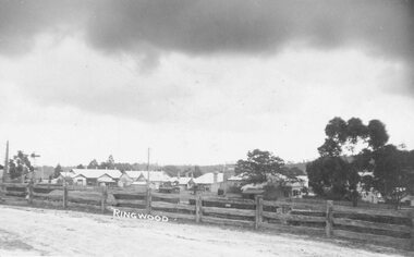
Photograph, Ringwood Reserve - North east corner. Now Eastland site - 1963
Typed below photograph, "Ringwood Reserve - North east corner. Now Eastland site - 1963"