Showing 10648 items matching "son "
-
 Kew Historical Society Inc
Plan - Subdivision Plan, Violet Farm Estate, 1927
Pru Sanderson, in her groundbreaking ‘City of Kew Urban Conservation Study : Volume 2 - Development History’ (1988), summarised the periods of urban development and subdivisions of land in Kew. The periods that she identified included 1845-1880, 1880-1893, 1893-1921, 1921-1933, 1933-1943, and Post-War Development. These periods were selected as they represented periods of rapid growth or decline in urban development. An obvious starting point for Sanderson’s groupings involved population growth and the associated economic cycles. These cycles also highlighted urban expansion onto land that was predominantly rural, although in other cases it represented the decline and breakup of large estates. A number of the plans in the Kew Historical Society’s collection can also be found in other collections, such as those of the State Library of Victoria and the Boroondara Library Service. A number are however unique to the collection.The Kew Historical Society collection includes almost 100 subdivision plans pertaining to suburbs of the City of Melbourne. Most of these are of Kew, Kew East or Studley Park, although a smaller number are plans of Camberwell, Deepdene, Balwyn and Hawthorn. It is believed that the majority of the plans were gifted to the Society by persons connected with the real estate firm - J. R. Mathers and McMillan, 136 Cotham Road, Kew. The Plans in the collection are rarely in pristine form, being working plans on which the agent would write notes and record lots sold and the prices of these.The subdivision plans are historically significant examples of the growth of urban Melbourne from the beginning of the 20th Century up until the 1980s. A number of the plans are double-sided and often include a photograph on the reverse. A subdivision plan for nineteen ‘bonny, airy building blocks’ on either side of Violet Grove, Kew East. Violet Grove runs between High Street and Harp Road. Like many other subdivisions in Kew and East Kew, older houses (Lots 1 and 13) were often included in the subdivision. Such houses were in some instances the original properties that were subdivided, or in the case of the Violet Grove subdivision, new houses such as the weatherboard villa on lot 13. This villa is advertised as having a tiled roof, 5 rooms, panelled hall, double doors (Rooms 14 x 12 ft. 6 in. (2) 14 x 12, 12 x 11, 13 x 11). A bricked front verandah, a tiled stove recess and existing sewerage connection added to its saleable potential. Water, electric light and power, and gas were all offered as part of the deal. Violet Grove now has about 35 houses, which indicates that the 19 lots of the subdivision were to be further subdivided by purchasers. [A similar plan is in the Batten & Percy Collection of the State Library of Victoria.]subdivision plans - east kew, violet farm estate, violet grove -- kew (vic.), boorool road -- kew (vic.), harp road -- kew east (vic.) -
 Kew Historical Society Inc
Plan - Subdivision Plan, Flower Farm Estate, East Kew, 1922
Pru Sanderson, in her groundbreaking ‘City of Kew Urban Conservation Study : Volume 2 - Development History’ (1988), summarised the periods of urban development and subdivisions of land in Kew. The periods that she identified included 1845-1880, 1880-1893, 1893-1921, 1921-1933, 1933-1943, and Post-War Development. These periods were selected as they represented periods of rapid growth or decline in urban development. An obvious starting point for Sanderson’s groupings involved population growth and the associated economic cycles. These cycles also highlighted urban expansion onto land that was predominantly rural, although in other cases it represented the decline and breakup of large estates. A number of the plans in the Kew Historical Society’s collection can also be found in other collections, such as those of the State Library of Victoria and the Boroondara Library Service. A number are however unique to the collection.The Kew Historical Society collection includes almost 100 subdivision plans pertaining to suburbs of the City of Melbourne. Most of these are of Kew, Kew East or Studley Park, although a smaller number are plans of Camberwell, Deepdene, Balwyn and Hawthorn. It is believed that the majority of the plans were gifted to the Society by persons connected with the real estate firm - J. R. Mathers and McMillan, 136 Cotham Road, Kew. The Plans in the collection are rarely in pristine form, being working plans on which the agent would write notes and record lots sold and the prices of these. The subdivision plans are historically significant examples of the growth of urban Melbourne from the beginning of the 20th Century up until the 1980s. A number of the plans are double-sided and often include a photograph on the reverse. The subdivision called the ‘Flower Farm Estate’ in Kew East occurred in 1922. It included 61 lots on either side of Boorool Road between High Street and Harp Road. In an advertisement in The Argus in the same year, the proximity of the estate to the newly erected shops at the corner of Harp Road and High Street is noted. The Flower Farm Estate and similar subdivisions in Kew East were assisted by the extension of the High Street tramline in 1924.subdivision plans - east kew, flower farm estate, high street - kew east (vic.), boorool road -- kew east (vic.), harp road -- kew east (vic.) -
 Kew Historical Society Inc
Plan - Subdivision Plan, Palmyra Estate, 1918
Pru Sanderson, in her groundbreaking ‘City of Kew Urban Conservation Study : Volume 2 - Development History’ (1988), summarised the periods of urban development and subdivisions of land in Kew. The periods that she identified included 1845-1880, 1880-1893, 1893-1921, 1921-1933, 1933-1943, and Post-War Development. These periods were selected as they represented periods of rapid growth or decline in urban development. An obvious starting point for Sanderson’s groupings involved population growth and the associated economic cycles. These cycles also highlighted urban expansion onto land that was predominantly rural, although in other cases it represented the decline and breakup of large estates. A number of the plans in the Kew Historical Society’s collection can also be found in other collections, such as those of the State Library of Victoria and the Boroondara Library Service. A number are however unique to the collection.The Kew Historical Society collection includes almost 100 subdivision plans pertaining to suburbs of the City of Melbourne. Most of these are of Kew, Kew East or Studley Park, although a smaller number are plans of Camberwell, Deepdene, Balwyn and Hawthorn. It is believed that the majority of the plans were gifted to the Society by persons connected with the real estate firm - J. R. Mathers & McMillan, 136 Cotham Road, Kew. The Plans in the collection are rarely in pristine form, being working plans on which the agent would write notes and record lots sold and the prices of these. The subdivision plans are historically significant examples of the growth of urban Melbourne from the beginning of the 20th Century up until the 1980s. A number of the plans are double-sided and often include a photograph on the reverse. In 1918, Punch reported the sale of the Palmyra Estate. ‘Adjoining the Findon Estate at Kew is Palmyra, one of the most charming localities in this most desirable of all suburbs. Palmyra has frontages to Findon, Bakewell, Carson and Stevenson streets. Facing Carson street are eight blocks of 60 by 140; on Stevenson-street four of 60 by 232; and there are four of 60 by 233 on Bakewell-street.’ [Bakewell Street and Findon Street were later to be amalgamated into Findon Crescent.]subdivision plans - kew, studley park, palymyra estate, stevenson street -- kew (vic.), carson street -- kew (vic.), bakewell street (findon crescent) -- kew (vic.) -
 Kew Historical Society Inc
Plan - Subdivision Plan, Tregarron Estate, Kew, c.1929
Pru Sanderson, in her groundbreaking ‘City of Kew Urban Conservation Study : Volume 2 - Development History’ (1988), summarised the periods of urban development and subdivisions of land in Kew. The periods that she identified included 1845-1880, 1880-1893, 1893-1921, 1921-1933, 1933-1943, and Post-War Development. These periods were selected as they represented periods of rapid growth or decline in urban development. An obvious starting point for Sanderson’s groupings involved population growth and the associated economic cycles. These cycles also highlighted urban expansion onto land that was predominantly rural, although in other cases it represented the decline and breakup of large estates. A number of the plans in the Kew Historical Society’s collection can also be found in other collections, such as those of the State Library of Victoria and the Boroondara Library Service. A number are however unique to the collection.Subdivision plans are historically important documents used as evidence of the growth of suburbs in Australia. They frequently provide information about when the land was sold on which a built structure was subsequently constructed as well as evidence relating to surveyors and real estate and financial agents. The numerous subdivision plans in the Kew Historical Society's collection represent working documents, ranging from the initial sketches made in planning a subdivision to printed plans on which auctioneers or agents listed the prices for which individual lots were sold. In a number of cases, the reverse of a subdivision plan in the collection includes a photograph of a house that was also for sale by the agent. These photographs provide significant heritage information relating house design and decoration, fencing and household gardens.In January 1929, the Kew City Council called for tenders to construct Tregarron Avenue. The subdivision of the Tregarron Estate in Kew was for 11 lots bordering Tregarron Avenue and its entrance from Burke Road. The plan includes annotations that indicate the measurement of each block and the placement of the drainage and sewerage easements. This plan is interesting for a number of factors. The house blocks today have different street numbers, some blocks were to be further subdivided, and at the time of the subdivision, alterations were still being made to the extent of lots offered; lots 2 and 3 on the plan were subdivided and reoriented.subdivision plans - kew, tregarron estate, tregarron avenue -- kew (vic.), burke road -- kew (vic.) -
 Kew Historical Society Inc
Plan - Subdivision Plan, Kewdene Estate, 1937-1939
Pru Sanderson, in her groundbreaking ‘City of Kew Urban Conservation Study : Volume 2 - Development History’ (1988), summarised the periods of urban development and subdivisions of land in Kew. The periods that she identified included 1845-1880, 1880-1893, 1893-1921, 1921-1933, 1933-1943, and Post-War Development. These periods were selected as they represented periods of rapid growth or decline in urban development. An obvious starting point for Sanderson’s groupings involved population growth and the associated economic cycles. These cycles also highlighted urban expansion onto land that was predominantly rural, although in other cases it represented the decline and breakup of large estates. A number of the plans in the Kew Historical Society’s collection can also be found in other collections, such as those of the State Library of Victoria and the Boroondara Library Service. A number are however unique to the collection.The Kew Historical Society collection includes almost 100 subdivision plans pertaining to suburbs of the City of Melbourne. Most of these are of Kew, Kew East or Studley Park, although a smaller number are plans of Camberwell, Deepdene, Balwyn and Hawthorn. It is believed that the majority of the plans were gifted to the Society by persons connected with the real estate firm - J. R. Mathers & McMillan, 136 Cotham Road, Kew. The Plans in the collection are rarely in pristine form, being working plans on which the agent would write notes and record lots sold and the prices of these. The subdivision plans are historically significant examples of the growth of urban Melbourne from the beginning of the 20th Century up until the 1980s. A number of the plans are double-sided and often include a photograph on the reverse. The advertisement for the ‘Kewdene Estate’ subdivision is pasted over a photograph of a property for sale. This is typical of the reuse of promotional materials in the period during, and subsequent to World War I. The subdivision included 14 lots bordered by Belmore Road, Birtles Street and Giles Street. On the other side of the subdivision [Glass] Creek is noted. The subdivision plan also shows part of the Outer Circle Railway and Deepdene Railway Station.subdivision plans - east kew, kewdene estate, belmore road -- kew east (vic.), giles street -- kew east (vic.) -
 Kew Historical Society Inc
Plan - Subdivision Plan, Boulevard Estate - Boulevard Section, 1930-1936
Pru Sanderson, in her groundbreaking ‘City of Kew Urban Conservation Study : Volume 2 - Development History’ (1988), summarised the periods of urban development and subdivisions of land in Kew. The periods that she identified included 1845-1880, 1880-1893, 1893-1921, 1921-1933, 1933-1943, and Post-War Development. These periods were selected as they represented periods of rapid growth or decline in urban development. An obvious starting point for Sanderson’s groupings involved population growth and the associated economic cycles. These cycles also highlighted urban expansion onto land that was predominantly rural, although in other cases it represented the decline and breakup of large estates. A number of the plans in the Kew Historical Society’s collection can also be found in other collections, such as those of the State Library of Victoria and the Boroondara Library Service. A number are however unique to the collection.The Kew Historical Society collection includes almost 100 subdivision plans pertaining to suburbs of the City of Melbourne. Most of these are of Kew, Kew East or Studley Park, although a smaller number are plans of Camberwell, Deepdene, Balwyn and Hawthorn. It is believed that the majority of the plans were gifted to the Society by persons connected with the real estate firm - J. R. Mathers and McMillan, 136 Cotham Road, Kew. The Plans in the collection are rarely in pristine form, being working plans on which the agent would write notes and record lots sold and the prices of these. The subdivision plans are historically significant examples of the growth of urban Melbourne from the beginning of the 20th Century up until the 1980s. A number of the plans are double-sided and often include a photograph on the reverse. This plan shows a subdivision with two sections: the ‘Boulevard Section’ and the ‘Riverside Section’. The first of these sections bordered Burke Road between Kilby Road and the farm beside the Yarra. Kilby Road, Munro Road, Burke Road and Old Burke Road bordered the 102 lots in the Boulevard Section of the plan. The streets within the Section included Walbundry Avenue, Inverness Way, Riverside Avenue, Cascade Street and Kyora Parade. These street names, at least in this subdivision plan linked the two Sections of the subdivision. At a later date, the City of Kew decided to alter the street names. Walbundry, Inverness, Riverside, Cascade and Kyora were all renamed as ‘Drives’ (e.g. Kyora Drive). The subdivision plan is of interest in that it names High Street in Kew as Doncaster Road. It also shows the location of the wooden church that was later removed to Yarraville on the corner of Kilby Road and High Street. The plan predates later developments such as the S. E. Dickens Supermarket.subdivision plans - east kew, boulevard estate, munro road -- kew east (vic.), kilby road -- kew east (vic.), burke road -- kew east (vic.), walbundry avenue -- kew east (vic.), inverness way -- kew east (vic.), riverside avenue -- kew east (vic.), cascade drive -- kew east (vic.), nyora parade -- kew east (vic.) -
 Kew Historical Society Inc
Plan - Subdivision Plan, Goldthorns Hill Estate, 1925
Pru Sanderson, in her groundbreaking ‘City of Kew Urban Conservation Study : Volume 2 - Development History’ (1988), summarised the periods of urban development and subdivisions of land in Kew. The periods that she identified included 1845-1880, 1880-1893, 1893-1921, 1921-1933, 1933-1943, and Post-War Development. These periods were selected as they represented periods of rapid growth or decline in urban development. An obvious starting point for Sanderson’s groupings involved population growth and the associated economic cycles. These cycles also highlighted urban expansion onto land that was predominantly rural, although in other cases it represented the decline and breakup of large estates. A number of the plans in the Kew Historical Society’s collection can also be found in other collections, such as those of the State Library of Victoria and the Boroondara Library Service. A number are however unique to the collection.The Kew Historical Society collection includes almost 100 subdivision plans pertaining to suburbs of the City of Melbourne. Most of these are of Kew, Kew East or Studley Park, although a smaller number are plans of Camberwell, Deepdene, Balwyn and Hawthorn. It is believed that the majority of the plans were gifted to the Society by persons connected with the real estate firm - J. R. Mathers and McMillan, 136 Cotham Road, Kew. The Plans in the collection are rarely in pristine form, being working plans on which the agent would write notes and record lots sold and the prices of these. The subdivision plans are historically significant examples of the growth of urban Melbourne from the beginning of the 20th Century up until the 1980s. A number of the plans are double-sided and often include a photograph on the reverse. The Goldthorns Hill Estate subdivision was first put up for auction in 1925. The subdivision took its name from the mansion ‘Goldthorns’, shown on the plan between Normanby Road and Lady Loch’s Drive. Contemporary advertisements describe forty-three home sites being fro sale, yet only forty-one appear on this plan. Buyers were lured by the prospect of the proposed extension of the Burke Road tram to High Street. Discerning buyers were advised that only one house could be built per allotment, and that houses needed to be constructed of brick, stone or concrete and have a slate or tiled roof.goldthorns avenue -- kew east (vic.), lady loch drive -- kew east (vic.), argyle road -- kew east (vic.), lady brassey drive -- kew east (vic.), campbell street -- kew east (vic.), goldthorns -- kew (vic.), subdivisions -- kew east (viv.), goldthorns hill estate -
 Kew Historical Society Inc
Map - Subdivision Plan, Grenville Estate, 1922
Pru Sanderson, in her groundbreaking ‘City of Kew Urban Conservation Study : Volume 2 - Development History’ (1988), summarised the periods of urban development and subdivisions of land in Kew. The periods that she identified included 1845-1880, 1880-1893, 1893-1921, 1921-1933, 1933-1943, and Post-War Development. These periods were selected as they represented periods of rapid growth or decline in urban development. An obvious starting point for Sanderson’s groupings involved population growth and the associated economic cycles. These cycles also highlighted urban expansion onto land that was predominantly rural, although in other cases it represented the decline and breakup of large estates. A number of the plans in the Kew Historical Society’s collection can also be found in other collections, such as those of the State Library of Victoria and the Boroondara Library Service. A number are however unique to the collection.Subdivision plans are historically important documents used as evidence of the growth of suburbs in Australia. They frequently provide information about when the land was sold on which a built structure was subsequently constructed as well as evidence relating to surveyors and real estate and financial agents. The numerous subdivision plans in the Kew Historical Society's collection represent working documents, ranging from the initial sketches made in planning a subdivision to printed plans on which auctioneers or agents listed the prices for which individual lots were sold. In a number of cases, the reverse of a subdivision plan in the collection includes a photograph of a house that was also for sale by the agent. These photographs provide significant heritage information relating house design and decoration, fencing and household gardens.In advertising the twenty-two sites of the Grenville Estate in Cotham Road and Alfred Street, Kew, the auctioneers emphasised the proximity of the development to shops, schools, and churches. That mansions surrounded the Estate was publicised as an added attraction. The plan shows how at this stage A regrettable aspect of this plan is that it is pasted over, and obscures a real estate photograph by the Kew photographer Josiah Earl Barnes.subdivision plans - kew, grenville estate, glenferrie road, alfred street, thomas street, cotham road -
 Kew Historical Society Inc
Plan - Subdivision Plan, Forres Estate, East Kew, 1919, 1919
Pru Sanderson, in her groundbreaking ‘City of Kew Urban Conservation Study : Volume 2 - Development History’ (1988), summarised the periods of urban development and subdivisions of land in Kew. The periods that she identified included 1845-1880, 1880-1893, 1893-1921, 1921-1933, 1933-1943, and Post-War Development. These periods were selected as they represented periods of rapid growth or decline in urban development. An obvious starting point for Sanderson’s groupings involved population growth and the associated economic cycles. These cycles also highlighted urban expansion onto land that was predominantly rural, although in other cases it represented the decline and breakup of large estates. A number of the plans in the Kew Historical Society’s collection can also be found in other collections, such as those of the State Library of Victoria and the Boroondara Library Service. A number are however unique to the collection.Subdivision plans are historically important documents used as evidence of the growth of suburbs in Australia. They frequently provide information about when the land was sold on which a built structure was subsequently constructed as well as evidence relating to surveyors and real estate and financial agents. The numerous subdivision plans in the Kew Historical Society's collection represent working documents, ranging from the initial sketches made in planning a subdivision to printed plans on which auctioneers or agents listed the prices for which individual lots were sold. In a number of cases, the reverse of a subdivision plan in the collection includes a photograph of a house that was also for sale by the agent. These photographs provide significant heritage information relating house design and decoration, fencing and household gardens.An annotated subdivision plan for the Forres Estate, Kew East. The estate was advertised in 1919, the Melbourne Auctioneers being represented locally by Henry Kellett, Estate Agent of High Street, Kew. The name of the estate was derived from the mansion (demolished 2016) of the same name in Normanby Road, which was at one stage owned by the Mayor of Kew, Cr. J. S. Were.subdivision plans - kew, forres estate, argyle road, simpson street, hubert street, normanby road -
 Kew Historical Society Inc
Plan - Subdivision Plan, St Helliers Estate, Kew, circa 1910, c.1910
Pru Sanderson, in her groundbreaking ‘City of Kew Urban Conservation Study : Volume 2 - Development History’ (1988), summarised the periods of urban development and subdivisions of land in Kew. The periods that she identified included 1845-1880, 1880-1893, 1893-1921, 1921-1933, 1933-1943, and Post-War Development. These periods were selected as they represented periods of rapid growth or decline in urban development. An obvious starting point for Sanderson’s groupings involved population growth and the associated economic cycles. These cycles also highlighted urban expansion onto land that was predominantly rural, although in other cases it represented the decline and breakup of large estates. A number of the plans in the Kew Historical Society’s collection can also be found in other collections, such as those of the State Library of Victoria and the Boroondara Library Service. A number are however unique to the collection.Subdivision plans are historically important documents used as evidence of the growth of suburbs in Australia. They frequently provide information about when the land was sold on which a built structure was subsequently constructed as well as evidence relating to surveyors and real estate and financial agents. The numerous subdivision plans in the Kew Historical Society's collection represent working documents, ranging from the initial sketches made in planning a subdivision to printed plans on which auctioneers or agents listed the prices for which individual lots were sold. In a number of cases, the reverse of a subdivision plan in the collection includes a photograph of a house that was also for sale by the agent. These photographs provide significant heritage information relating house design and decoration, fencing and household gardens.In the subdivision of part of Crown Portion 82, bordered by John and Sackville Streets and Cotham and Burke Roads, over 100 lots were offered for sale. In addition to the designated lots, a number of key locations are also identified. These include the Genazzano Convent to the north of Cotham Road, the Reservoir, St Hilary’s and the land holding of Colonel Parnell on the corner of John Street and Cotham Road. On the Plan, No. 5064, is the handwritten name ‘St. Hellier’s Estate’. St. Helliers, the home of the Dumaresq family is shown beside St. Hilary’s.subdivision plans - kew, st helliers estate -
 Kew Historical Society Inc
Plan - Subdivision Plan, Jas R Mathers Son & McMillan, East Kew Tramway Estate, 1915
Pru Sanderson, in her groundbreaking ‘City of Kew Urban Conservation Study : Volume 2 - Development History’ (1988), summarised the periods of urban development and subdivisions of land in Kew. The periods that she identified included 1845-1880, 1880-1893, 1893-1921, 1921-1933, 1933-1943, and Post-War Development. These periods were selected as they represented periods of rapid growth or decline in urban development. An obvious starting point for Sanderson’s groupings involved population growth and the associated economic cycles. These cycles also highlighted urban expansion onto land that was predominantly rural, although in other cases it represented the decline and breakup of large estates. A number of the plans in the Kew Historical Society’s collection can also be found in other collections, such as those of the State Library of Victoria and the Boroondara Library Service. A number are however unique to the collection.The Kew Historical Society collection includes almost 100 subdivision plans pertaining to suburbs of the City of Melbourne. Most of these are of Kew, Kew East or Studley Park, although a smaller number are plans of Camberwell, Deepdene, Balwyn and Hawthorn. It is believed that the majority of the plans were gifted to the Society by persons connected with the real estate firm - J. R. Mathers and McMillan, 136 Cotham Road, Kew. The Plans in the collection are rarely in pristine form, being working plans on which the agent would write notes and record lots sold and the prices of these. The subdivision plans are historically significant examples of the growth of urban Melbourne from the beginning of the 20th Century up until the 1980s. A number of the plans are double-sided and often include a photograph on the reverse. A number of the latter are by noted photographers such as J.E. Barnes.The East Kew Tramway Estate was a subdivision of two separate parcels of land between Adeney Avenue and Normanby Road. The larger section included 54 lots facing Adeney Avenue, Argyle Road, and Campbell, Hunter and Wishart Streets. [Hunter and Wishart Streets were created as part of the subdivision.] A further 17 allotments faced Normanby Road, Hubert and Campbell Streets. [The name of Hubert Street was later to be changed to Cecil Street.] The promotion of the sale referred to the advantages of living between two tram routes, in High Street and Cotham Road. On the plan, quaintly drawn trams mark these routes. Also on the plan is the route of part of the Outer Circle [Railway] Line.east kew tramway estate, subdivision plans - east kew -
 Kew Historical Society Inc
Plan - Subdivision Plan, Jas R Mathers Son & McMillan, Macartney Estate, East Kew, c. 1925
Pru Sanderson, in her groundbreaking ‘City of Kew Urban Conservation Study : Volume 2 - Development History’ (1988), summarised the periods of urban development and subdivisions of land in Kew. The periods that she identified included 1845-1880, 1880-1893, 1893-1921, 1921-1933, 1933-1943, and Post-War Development. These periods were selected as they represented periods of rapid growth or decline in urban development. An obvious starting point for Sanderson’s groupings involved population growth and the associated economic cycles. These cycles also highlighted urban expansion onto land that was predominantly rural, although in other cases it represented the decline and breakup of large estates. A number of the plans in the Kew Historical Society’s collection can also be found in other collections, such as those of the State Library of Victoria and the Boroondara Library Service. A number are however unique to the collection.Subdivision plans are historically important documents used as evidence of the growth of suburbs in Australia. They frequently provide information about when the land was sold on which a built structure was subsequently constructed as well as evidence relating to surveyors and real estate and financial agents. The numerous subdivision plans in the Kew Historical Society's collection represent working documents, ranging from the initial sketches made in planning a subdivision to printed plans on which auctioneers or agents listed the prices for which individual lots were sold. In a number of cases, the reverse of a subdivision plan in the collection includes a photograph of a house that was also for sale by the agent. These photographs provide significant heritage information relating house design and decoration, fencing and household gardens.The Macartney Estate subdivision advertised 21 lots for sale on either side of Macartney Street (now Macartney Avenue) and Evans Road in what was then designated as East Kew. Most of the houses shown on the south side of Macartney Street then, as now, have rear entrances on Mount Street, however a number of these blocks have since been further subdivided to allow for the building of new houses on the rear of a block. Brougham Place is marked on the plan but is now called Daniell Place."C"subdivision plans - east kew, macartney estate, macartney street, mount street, evans road, brougham place -
 Kew Historical Society Inc
Plan - Subdivision Plan, Jas R Mathers Son & McMillan, The Dale Estate, Deepdene, 1918
Pru Sanderson, in her groundbreaking ‘City of Kew Urban Conservation Study : Volume 2 - Development History’ (1988), summarised the periods of urban development and subdivisions of land in Kew. The periods that she identified included 1845-1880, 1880-1893, 1893-1921, 1921-1933, 1933-1943, and Post-War Development. These periods were selected as they represented periods of rapid growth or decline in urban development. An obvious starting point for Sanderson’s groupings involved population growth and the associated economic cycles. These cycles also highlighted urban expansion onto land that was predominantly rural, although in other cases it represented the decline and breakup of large estates. A number of the plans in the Kew Historical Society’s collection can also be found in other collections, such as those of the State Library of Victoria and the Boroondara Library Service. A number are however unique to the collection.The Kew Historical Society collection includes almost 100 subdivision plans pertaining to suburbs of the City of Melbourne. Most of these are of Kew, Kew East or Studley Park, although a smaller number are plans of Camberwell, Deepdene, Balwyn and Hawthorn. It is believed that the majority of the plans were gifted to the Society by persons connected with the real estate firm - J. R. Mathers and McMillan, 136 Cotham Road, Kew. The Plans in the collection are rarely in pristine form, being working plans on which the agent would write notes and record lots sold and the prices of these. The subdivision plans are historically significant examples of the growth of urban Melbourne from the beginning of the 20th Century up until the 1980s. A number of the plans are double-sided and often include a photograph on the reverse. A number of the latter are by noted photographers such as J.E. Barnes.The Dale Estate in Deepdene was made possible by the death of Robert Sparrow Smythe, Australian journalist, newspaper editor/owner and theatrical manager. Smythe lived in his residence ‘Highate’, Deepdene until his death in 1917. In the subdivision proposed one year later, before the end of the First World War, 18 allotments were to be created. The very fragmentary plan in the Society’s collection notes that a large weatherboard [house] will need to be removed. This may be Smythe’s own home. The proposed subdivision included allotments facing Burke and Whitehorse Roads and Dale Street. Bordering the subdivision is the Deepdene Station and the Outer Circle Railway Line. The clear directions on the plan indicate that in 1918 it was possible to travel by train from Deepdene to East Camberwell and Ashburtonsubdivision plans - deepdene, the dale estate -
 Kew Historical Society Inc
Plan - Subdivision Plan, Jas R Mathers Son & McMillan, Clifton Estate, Kew, c. 1916
Pru Sanderson, in her groundbreaking ‘City of Kew Urban Conservation Study : Volume 2 - Development History’ (1988), summarised the periods of urban development and subdivisions of land in Kew. The periods that she identified included 1845-1880, 1880-1893, 1893-1921, 1921-1933, 1933-1943, and Post-War Development. These periods were selected as they represented periods of rapid growth or decline in urban development. An obvious starting point for Sanderson’s groupings involved population growth and the associated economic cycles. These cycles also highlighted urban expansion onto land that was predominantly rural, although in other cases it represented the decline and breakup of large estates. A number of the plans in the Kew Historical Society’s collection can also be found in other collections, such as those of the State Library of Victoria and the Boroondara Library Service. A number are however unique to the collection.The Kew Historical Society collection includes almost 100 subdivision plans pertaining to suburbs of the City of Melbourne. Most of these are of Kew, Kew East or Studley Park, although a smaller number are plans of Camberwell, Deepdene, Balwyn and Hawthorn. It is believed that the majority of the plans were gifted to the Society by persons connected with the real estate firm - J. R. Mathers and McMillan, 136 Cotham Road, Kew. The Plans in the collection are rarely in pristine form, being working plans on which the agent would write notes and record lots sold and the prices of these. The subdivision plans are historically significant examples of the growth of urban Melbourne from the beginning of the 20th Century up until the 1980s. A number of the plans are double-sided and often include a photograph on the reverse. A number of the latter are by noted photographers such as J.E. Barnes.The Clifton Estate was an ambitious subdivision. It included 61 allotments bordering Cotham and Park Hill Roads, and Florence and Adeney Avenues. It is difficult to ascertain the exact year when the ‘Clifton Estate’ was surveyed, subdivided and first auctioned. The uncertainty may be due to allotments being released during the First World War. The subdivision took its name from the house ‘Clifton’ (lot 5) on the corner of Adeney Avenue and Cotham Road. The outline of Clifton (since demolished) and the extent of its land following the subdivision are represented on the plan. The auctioneers have also shown ‘Maryfield’ and ‘Wimba’, the neighbouring properties in Cotham Road, on the plan."B"subdivision plans - kew, clifton estate, cotham road, adeney avenue, florence avenue, park hill road -
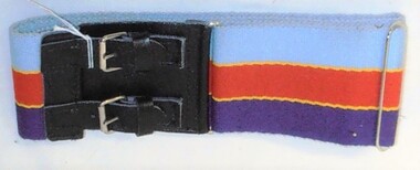 8th/13th Victorian Mounted Rifles Regimental Collection
Uniform - Stable Belt, 1980 circa
Regimental stable belts were worn with Howard Green jumper and with summer polyester uniform. They were introduced as uniform in late 1970s and withdrawn from use in 1995. Each regiment had a belt of distinctive colours.Fine example of item of apparel worn by Australian soldiers in 1980s, one of few colourful items of uniform in modern times.Five coloured 8th/13th Victorian Mounted Rifles stable belt with two leather fastening straps and metal buckles. Belt contains the colours of the 8th Light Horse Regiment, blue and yellow, 13th Light Horse Regiment, red and white, and 20th Light Horse Regiment, purple and yellow. uniform, belt, 8/13 vmr, military -
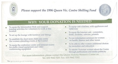 Queen Victoria Women's Centre
Envelope, E.S. Wigg & Son Pty. Ltd, c.1996
1996 Queen Vic. Shilling Fund donation Reply Paid envelope. Cream paper. Green and navy blue ink. envelopes, charitable organisations -
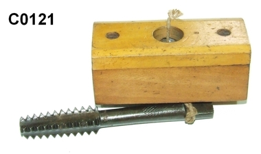 Hand Tool Preservation Association of Australia Inc
Screw Box & Tap, D Flather & Son
This Item is part of the Thomas Caine Collection owned by National Trust of Victoria.Screw Box & Tap H. E. Barrett -
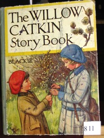 Stawell Historical Society Inc
Book, Blackie & Son Limited, The Willow Catkin Story Book, 1938
Holy Trinity Kindergarten. Presented to Allan Smithstawell -
 Federation University Art Collection
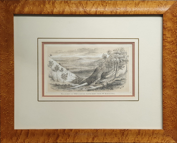
Work on paper - Lithograph, Ballarat in 1852.(Looking North West from Mt Buninyong), 1887
This item is part of the Federation University Art Collection. The Art Collection features over 2000 works and was listed as a 'Ballarat Treasure' in 2007.Framed chromo-lithograph depicting a landscape with deep slopes. The lithograph is from Withers 'History of Ballarat'.art, artwork, s.t. gill, samuel thomas gill, f.w. niven, buninyong, ballarat, landscape, available -
 Federation University Art Collection
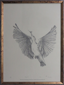
Artwork, 'Kingfisher' by Earl Ingleby
Earl INGELBY (1939- ) After training at RMIT in 1960s, Earl Ingleby worked and undertook further training in Europe before returning to Australia in late 1969. He currently lives and works in Creswick, Victoria. This item is part of the Federation University Art Collection. The Art Collection features over 2000 works and was listed as a 'Ballarat Treasure' in 2007.One in as set of three. .1) Lithograph of a kingfisherSigned and editioned at lower side "5/50 Kingfisher Litho E. Inglebyart, artwork, earl ingleby, j.a. hoskin, bird, kingfisher, available, fauna -
 Lilydale RSL Sub Branch
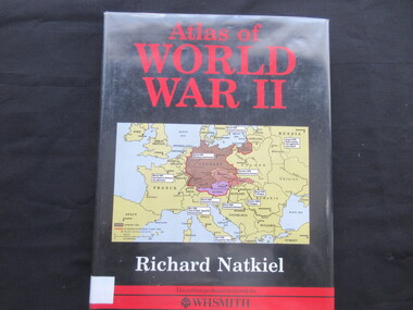
Book, Richard Natkiel, Atlas of World War 11, 1985
Book -
 Lilydale RSL Sub Branch
Book, Field-Marshal Earl Alexander of Tunis, The Alexander Memoirs 1940-1945, 1962
Book -
 Lilydale RSL Sub Branch
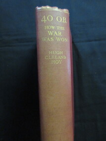
Book, Hugh Cleland Hoy, 40 O.B./ How the War was Won, 1932
-
 City of Greater Bendigo - Civic Collection
Photograph - Portrait of Councillor Keck, W H Robinson, c 1913
The district of Strathfieldsaye was proclaimed in 1861 and named a Shire on the 17th September in 1866. It remained a shire until amalgamation in 1994 when it became part of the City of Greater Bendigo. The shire was located 8 km to the south- east of Bendigo and covered an area of 601 square kilometres and extended from the Calder Highway to the Coliban and Campaspe Rivers. The shire's administration centre was in Strathfieldsaye until 1972 when new offices were opened in Kennington.Framed black and white head and shoulder portrait of Councillor Keck with hand coloured and drawn detail. Profile slightly to right with walrus moustache. Cut oval brown mount decorated with text and flowers. Hand written title top and lower centre.Strathfieldsaye / Shire Council / W.H. Robinson / Photo / Bendigo / J.H.E Gribbs / Presented by / Cr Herbert Keck / President 1903-4. 1912-13.shire of strathfieldsaye, councillor keck, strathfieldsaye shire council, president of strathfieldsaye shire -
 City of Greater Bendigo - Civic Collection
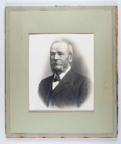
Photograph - Portrait of Councillor Thomas Somerville, W H Robinson
The district of Strathfieldsaye was proclaimed in 1861 and named a Shire on the 17th September in 1866. It remained a shire until amalgamation in 1994 when it became part of the City of Greater Bendigo. The shire was located 8 km to the south- east of Bendigo and covered an area of 601 square kilometres and extended from the Calder Highway to the Coliban and Campaspe Rivers. The shire's administration centre was in Strathfieldsaye until 1972 when new offices were opened in KenningtonFramed black and white head and shoulder portrait of Councillor Somerville with hand drawn detail. Profile slightly to left, face has full beard. Cut oval brown mount decorated with text and scrolls. Hand written title top and lower centre.Presented to / Strathfieldsaye / Shire Council / W. H. Robinson / Photo / Bendigo / by / Cr Thomas Somerville / President 1892 - 3. 1901.2. 1910.11 strathfieldsaye shire council, councillor somerville, president of strathfieldsaye shire -
 City of Greater Bendigo - Civic Collection
Photograph - Portrait of Councillor Michael Condon, W H Robinson
The district of Strathfieldsaye was proclaimed in 1861 and named a Shire on the 17th September in 1866. It remained a shire until amalgamation in 1994 when it became part of the City of Greater Bendigo. The shire was located 8 km to the south- east of Bendigo and covered an area of 601 square kilometres and extended from the Calder Highway to the Coliban and Campaspe Rivers. The shire's administration centre was in Strathfieldsaye until 1972 when new offices were opened in KenningtonFramed black and white head and shoulder portrait of Councillor Condon with hand coloured and drawn detail. Profile slightly to left. No facial hair. Cut oval brown mount decorated with text, scrolls and flowers. Hand written title top and lower centre.Strathfieldsaye / Shire / Council / W. H. Robinson / Photo / Bendigo / JMB Gribble / Presented by / Cr Michael Condon / President 1889 - 90. 1895-6. 1904 - 5strathfieldsaye shire council, president of strathfieldsaye shire, councillor condon -
 City of Greater Bendigo - Civic Collection
Photograph - Portrait of Councillor Sibley, W H Robinson
The district of Strathfieldsaye was proclaimed in 1861 and named a Shire on the 17th September in 1866. It remained a shire until amalgamation in 1994 when it became part of the City of Greater Bendigo. The shire was located 8 km to the south- east of Bendigo and covered an area of 601 square kilometres and extended from the Calder Highway to the Coliban and Campaspe Rivers. The shire's administration centre was in Strathfieldsaye until 1972 when new offices were opened in KenningtonFramed black and white head and shoulder portrait of Councillor Sibley with hand coloured and drawn detail. Profile slightly to left with walrus moustache and beard. Cut oval brown mount decorated with text, flowers and scrolls. Hand written title top and lower centre.Strathfieldsaye / Shire Council / W m Robinson / Photo / Bendigo / J N B Gribble / Cr Robert R Sibley / First President Chairman of the Road Board 1865 - 5 / President 1866 - 1869 / With Mrs Sibley's Complimentsstrathfieldsaye shire council, councillor sibley, president of strathfieldsaye shire -
 City of Greater Bendigo - Civic Collection
Photograph - Portrait of Councillor Long, Talma & Co
The district of Strathfieldsaye was proclaimed in 1861 and named a Shire on the 17th September in 1866. It remained a shire until amalgamation in 1994 when it became part of the City of Greater Bendigo. The shire was located 8 km to the south- east of Bendigo and covered an area of 601 square kilometres and extended from the Calder Highway to the Coliban and Campaspe Rivers. The shire's administration centre was in Strathfieldsaye until 1972 when new offices were opened in Kennington.Framed black and white head and shoulder portrait of Councillor Long. Profile to left with walrus moustache and mutton chops. Cut olive retangle mount. Verso; Long. On under board which has photograph attached; Talma & Co. / 119 Swanston St., / Melbournestrathfieldsaye shire council, councillor long -
 City of Greater Bendigo - Civic Collection
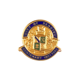
Decorative object - City of Bendigo Centenary decorative pin, Stokes and Son, 1951
Medal commemorating the centenary of the establishment of a settlement on Bendigo Creek. (.1) Small, circular, gold pin with blue and green enamel. below. (.2) Seventeen numbered paper envelopes containing single pin.Face of pin has the City of Bendigo Coat of Arms in relief with 'City of Bendigo' above and 'Centenary 1851 - 1961' city of greater bendigo medals -
 Mrs Aeneas Gunn Memorial Library
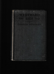
Book, Dean and Son, Westward Ho, ????
Charles Kingsley's Westward Ho! is the novel after which the English seaside village was named. The story follows the adventures of Amyas Leigh, an obstinate young man who decides to go sailing. He settles for a certain period in the Caribbean islands searching for gold and succeeds in making a little fortune. He then decides to go back to England by the time of the Spanish Armada, a sixteenth-century Spanish fleet that intended to invade England and overthrow Queen Elizabeth I for rivalry over colonies in the Netherlands, the Atlantic and the Pacific. Much of the novel describes the struggles between the two world powers, picturing the continuous naval battles that they engaged in. Amayas becomes greatly concerned when the Spaniards abduct his brother Frank Leigh as well as an admired local beauty named Rose Salterne. Furthermore, Amyas's life turns into a sad tragedy when he is further struck by a thunderbolt that costs him his eyesight. Generally, Kingsley gives the story a religious touch by making the war between England and Spain equally appear like a war between Protestantism and Catholicism, particularly when he shows how English hostages are often burnt at the stake by the Catholic Inquisition.p.407.fictionCharles Kingsley's Westward Ho! is the novel after which the English seaside village was named. The story follows the adventures of Amyas Leigh, an obstinate young man who decides to go sailing. He settles for a certain period in the Caribbean islands searching for gold and succeeds in making a little fortune. He then decides to go back to England by the time of the Spanish Armada, a sixteenth-century Spanish fleet that intended to invade England and overthrow Queen Elizabeth I for rivalry over colonies in the Netherlands, the Atlantic and the Pacific. Much of the novel describes the struggles between the two world powers, picturing the continuous naval battles that they engaged in. Amayas becomes greatly concerned when the Spaniards abduct his brother Frank Leigh as well as an admired local beauty named Rose Salterne. Furthermore, Amyas's life turns into a sad tragedy when he is further struck by a thunderbolt that costs him his eyesight. Generally, Kingsley gives the story a religious touch by making the war between England and Spain equally appear like a war between Protestantism and Catholicism, particularly when he shows how English hostages are often burnt at the stake by the Catholic Inquisition. england - fiction, spanish armada