Showing 171385 items matching "streets"
-
 Kew Historical Society Inc
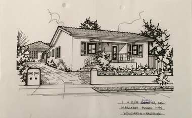
Drawing - Property Illustration, Margaret Picken, 1 + 2 / 19 Duke Street, Kew, 1995
After training as a Cartographic Draftsman within the mining industry, I worked as a property illustrator for real estate firms in the eastern suburbs of Melbourne for 23 years from 1983. I initially photographed houses with a Polaroid camera and made a 'thumbnail' sketch while there. The photos were used to scale off a sketch in pencil and then that sketch was overlaid with drafting film and the 'pen and ink' completed. The pens I used were the Rotring ‘Rapidigraph’ drafting pens. The ink was also made by Rotring (German).The film was ‘Rapidraw’, polyester drafting film, double matte. It takes a very fine line and doesn’t bleed. As well as house sketches, there were often floor plans and site plans ordered. Aerial sketches were ordered when the property needed an overall view. (Margaret Picken, 2020)This drawing is one of a series created by Margaret Picken for a range of real estate agents in Melbourne between c.1983 and c.2005. Each work is signed and dated by the artist.Gift of Margaret Picken, 2020Pen and ink architectural drawing on drafting film of 1 + 2 / 19 Duke Street, Kew by Margaret Picken.1 + 2 / 19 DUKE STREET, KEW / MARGARET PICKEN ~95 / WOODARDS ~ HAWTHORNartist -- margaret picken 1950-, architectural drawings -- houses -- kew (vic.), 1 + 2 /19 duke street - kew (vic.) -
 Linton and District Historical Society Inc
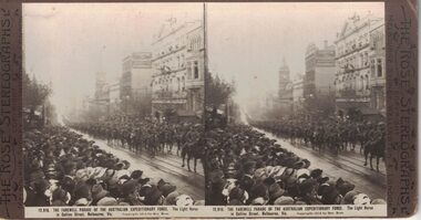
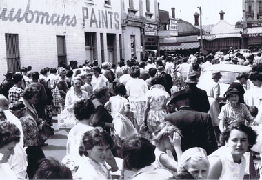
Stereograph, The Rose Stereographs, Melbourne, Sydney, Wellington and London, 12, 916 Farewell Parade, Australian Expeditionary Force, Collins Street, Melbourne, Copyright 1914
One of two sets of stereographs donated by the O'Beirne family along with a stereoscope for viewing (Stereoscope is Registration no. 2014-51).Large crowd of people lined up along Collins Street, Melbourne watching Light Horse Brigade pass by."12,916 THE FAREWELL PARADE OF THE AUSTRALIAN EXPEDITIONARY FORCE. The Light Horse / in Collins Street, Melbourne."stereographs, australian expeditionary force -
 Port Melbourne Historical & Preservation Society
Photograph - Demolition, 225 Princes Street, Port Melbourne, Pat Grainger
225 Princes Street was sold and demolished after its owner, Ted Young, was brutally murdered there (multiple stabbing). Police thought they knew who did it but had no evidence. Wall of Milk Bar across Princes Street was subsequently demolished.One of three colour photos of 225 Princes Street following demolition (2000?): .01 View from Princes Street through to the back of 70 Station StreetSome notes in pencilbuilt environment - domestic, demolitions, crimes and misdemeanours, edward (ted) young -
 Phillip Island and District Historical Society Inc.
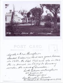
Photograph - Post Card, Osborne Park Guest House Phillip Island, 1930's
Black & White photograph of a postcard. Postcard owned by Jan Stewart, Jan & John Stewart operated Bayside Caravan Park, 7 Beach Street, Cowes. This was the site of "Osbourne Park".Black & Whte photograph of a postcard, front and back. Osbourne Park Guest House in Beach Street, Cowes Front: No. 96. "Osbourne Park" - Cowes. Back: Myrtle & Ern Humphries started Osbourne Park as a guest house in 1929. He dies 1937 and she in 1943. She is buried in Phillip Is Cemetery under the name of Dunstan. Ruth Gibson nee Humphries, 69 Victoria Street, Hastings 3915. Ben Humphries Romake, 5/6 Stewart St., Port Macquarie 2444.osbourne park guesthouse phillip island, guesthouses cowes phillip island, myrtle & ern humphries, elaine alexander -
 Marysville & District Historical Society
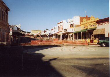
Photograph (Item) - Colour photograph, Travel Victoria, 2006
A colour photograph of Murchison Street in Marysville in Victoria.A colour photograph of Murchison Street in Marysville in Victoria. The photograph shows the roundabout at the corner of Murchison and Lyell Streets.murchison street, lyell street, marysville, victoria, photograph -
 Marysville & District Historical Society
Photograph (Item) - Colour photograph, Travel Victoria, 2006
A colour photograph of Murchison Street in Marysville in Victoria.A colour photograph of Murchison Street in Marysville in Victoria. This photograph is taken of the view down Murchison Street from the roundabout on the corner of Murchison and Lyell Streets.murchison street, lyell street, marysville, victoria, photograph -
 Stawell Historical Society Inc
Photograph, Gold Reef Mall -- Main Street Stawell 2003
Gold Reef Mall Main Street 2003Colour Photograph: Looking Eastfrom the Main Street / Wimmera Street intersection, with roundabout partialy installedstawell business -
 Kew Historical Society Inc
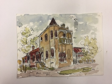
Work on paper, Joy Stewart, Peel Street, Kew, 1978
Sydney Joy (joy) Stewart (1925-2018) was a founding member of the Kew Historical Society, and during the 1970s its secretary. During her residence in Kew, she completed numerous property illustrations on commission. These ranged from preliminary sketches, including architectural details to finished pen & ink and wash illustrations on paper. On moving to Queensland, Joy Stewart donated the remaining property illustrations in her possession to the Kew Historical Society. In 1987-88, she fulfilled a commission by the Society of designs for a series of embroideries completed by residents during the Australian Bicentennial commemorations.Sydney Joy (Joy) Stewart was born in Melbourne 1925. She studied at Swinburne Technical College Art School from 1941-1945, then the National Gallery Art School 1946-1948. Her career included employment positions as a display artist, designer/painter, gallery assistant, and art teacher. Joy relocated to Cairns in 1981. Solo exhibitions in Melbourne and Cairns, including 'Done By Me' at Cairns Regional Gallery in 1999. Group exhibitions at Cairns Regional Gallery, 'The Fish John West Regrets, 1993' and 'Facets of Life' 1994. Joy Stewart died in Cairns in 2018.Watercolour, pen & Ink on paper by the artist and local historian Joy Stewart of a distinctive two-storey Victorian-era house in Peel Street, Kew. Inscription: "Peel Street, Kew." Signed lower right: "JStewart 1978"joy stewart, peel street (kew) -
 Linton and District Historical Society Inc
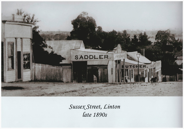
Photograph, Sussex Street, Linton, late 1890s
This scanned and labelled image has been copied from an original image lent from the LDHS collection in June 2001; copied by John O'Sullivan, the great grandson of Patrick and Ellen O'Sullivan. The photo is dated to the 1890s by the other shops in Sussex St (G.G. Bennett is known to have established a butcher's shop in about 1896).Black and white photograph of row of shops in Sussex Street, Linton, including P. O'Sullivan, saddler and harness maker, and G. G. Bennett, butcher.On front: "Patrick O'Sullivan's Saddlery, Sussex Street, Linton in late 1890s"sussex street linton, john o'sullivan, patrick o'sullivan, ellen o'sullivan, saddlers, butchers, c.g. bennett -
 Kew Historical Society Inc
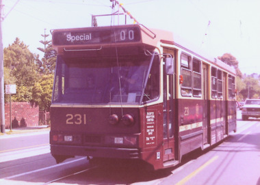
Photograph - A Class 231 in High Street South, 1990
This colour photograph, with 15 others are enlargements gifted to the Society by Mel Lawrence in 2016. They were taken at a commemorative event from the Kew Tram Depot. Laminated colour enlargement of A Class tram 231 in High Street South, during a re-enactment from the Kew Depot in 1990.Annotation reverse: "Kew Depot 1990. A Class 231 in High Street South"kew tram depot, trams -- melbourne, a class trams -
 Bendigo Historical Society Inc.
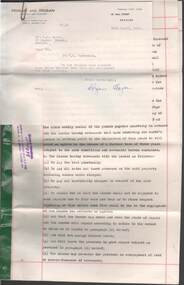
Document - W.D.MASON COLLECTION: PROPERTY LEASE, 5 April 1962
Cream Legal Document dated 5.4.1962 , W.D.Mason Collection, Property Lease for the premises at the corner of Myers and Williamson streets from Walter David Mason to Mr.Philip. Stanley Tuddenham with letter from Hogan and Hogan Barristers and Solicitors.Hogan and Hogan,Solicitors, Bull Street, Bendigo.business, retail, w d mason -
 Ringwood and District Historical Society
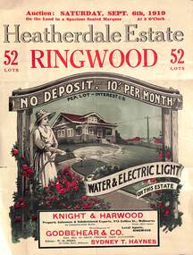
Pamphlet - Land Auction Brochure, Heatherdale Estate, Ringwood, Victoria - 1919
Double sided leaflet advertising subdivision site, layout of streets and allotments, summary of local features and services and terms of sale. Inset photographs of local views and residence of F.W. Purches on the Estate.Auction Saturday September 6th, 1919. 52 Lots. Subdivision includes White Horse Road, Witt Street, Mitcham, Station Street (later Victory Street, Mitcham). (Railway Avenue marked on the map did not eventuate). Agents - Knight & Harwood, 315 Collins Street, Melbourne in conjunction with Godbehear & Co, Phone Ringwood 49, selling through their auctioneer - Sydney T. Haynes. Solicitor W.H. Peers, 395 Collins Street, Melbourne. -
 Northern District School of Nursing. Managed by Bendigo Historical Society Inc.
Photograph - Schools 21 and 22
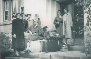
The Northern District School of Nursing opened in 1950 in to address the issues around nurse recruitment, training and education that had previously been hospital based. The residential school was to provide theoretical and in-house education and practical training over three years. The students would also receive practical hands-on training in the wards of associated hospitals. The Northern District School of Nursing operated from Lister House, Rowan Street, Bendigo. It was the first independent school of nursing in Victoria and continued until it closed in 1989.Black and white photograph of seven nurses in casual clothes sitting and standing on steps at Wattle Street nurses home. 1955 or 1956Names written on back. L to R - Helen Ryan, Heather Midgley, Elaine Sweeney, Vera Hoensch, Rae Eyles, Ida Moore, Margaret Arnoldt seated on luggage. Wattle Street, Bendigo ?1955 or 56seven student nurses in casual clothes., standing on steps of nurses home. -
 Federation University Historical Collection
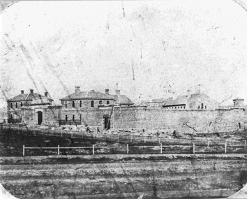
Photograph - Photograph - Black and White, Former Ballarat Gaol, c1861, c1861
The former Ballarat Gaol was commenced in 1856 and completed in 1862, This view looks up Lydiard Street South, and was taken before the Ballarat Courthouse was built south of the gaol in 1868. The wall was built from quarried basalt with local bricks. A system of burning the lime mortar between the joints and the shape of the wall meant it had a high degree of stability. From 1870 on more buildings were constructed and these became the School of Mines and Industries Ballarat. The Gaol closed in 1965. This image shows the Ballarat Gaol c. 1861 giving us an understanding of what the site looked like before all the changes that have occurred over the years since the gaol closed and other organisations have had the site. Black and white image showing the former Ballarat Gaol from Lydiard Street South.Label on underneath photograph: The Ballarat Gaol, c.1861 - This view looks up Lydiard Street towards our present school entrance. The gaol buildings remain unchanged . Note that the Court House, now S.M.B's Elec. classrooms, has not yet been built on the right hand side of the gaol.ballarat gaol, ballarat school of mines, gaol, m113, lydiard street, courthouse, lime mortar, lydiard street south -
 St Kilda Historical Society
Photograph, Woodstock Street, Balaclava, 1/11/1962
Opening of carpark Camden Street Balaclava black and white photograph, unmounted, original, good conditionOn back: Some of the crowd in Woodstock Street -
 Surrey Hills Historical Society Collection
Compact disc, Victorian Directory 1921-1925 (Sands & McDougall) (5 discs)
... streets ...The Sands and McDougall directories are amongst the most comprehensive. You can find out more details about places in which people lived, the other residents in the area, the services available in the region...all of which help to paint a picture of your ancestors' life. Apart from the Street,Alphabetical, Trade and Professional directories, this volume also contains Government and Official, Ecclesiastical, Legal, Municipal, Colonial, Societies and Institutions directories. This compendium of Sands and McDougall's directories covers 1916-1920. Each is very comprehensive containing the following sub-directories: city streets Directory: with a street index, and street by street listings of all houses and the householder at each address. Country directory: that lists people alphabetically for each town and their occupation. Alphabetical Directory: covering the whole of Victoria. Melbourne and Suburban Professional & Trade Directory: listing people by their trade. Country Professional & Trade Directory: complements the Melbourne list to give coverage of all Victoria. It also includes Agriculture and Pastoral; Government and Official; Legal and Judicial including Justices of the Peace; Ecclesiastical.The Sands and McDougall directories are amongst the most comprehensive. You can find out more details about places in which people lived, the other residents in the area, the services available in the region...all of which help to paint a picture of your ancestors' life. Apart from the Street,Alphabetical, Trade and Professional directories, this volume also contains Government and Official, Ecclesiastical, Legal, Municipal, Colonial, Societies and Institutions directories.streets, trade, agriculture, government, legal, ecclesiastical, farmers, farm workers, clergy -
 Surrey Hills Historical Society Collection
Compact disc, Victorian Directory 1926-1930 (Sands & McDougall) (5 discs)
... streets ...The Sands and McDougall directories are amongst the most comprehensive. You can find out more details about places in which people lived, the other residents in the area, the services available in the region...all of which help to paint a picture of your ancestors' life. Apart from the Street,Alphabetical, Trade and Professional directories, this volume also contains Government and Official, Ecclesiastical, Legal, Municipal, Colonial, Societies and Institutions directories. This compendium of Sands and McDougall's directories covers 1916-1920. Each is very comprehensive containing the following sub-directories: city streets Directory: with a street index, and street by street listings of all houses and the householder at each address. Country directory: that lists people alphabetically for each town and their occupation. Alphabetical Directory: covering the whole of Victoria. Melbourne and Suburban Professional & Trade Directory: listing people by their trade. Country Professional & Trade Directory: complements the Melbourne list to give coverage of all Victoria. It also includes Agriculture and Pastoral; Government and Official; Legal and Judicial including Justices of the Peace; Ecclesiastical.The Sands and McDougall directories are amongst the most comprehensive. You can find out more details about places in which people lived, the other residents in the area, the services available in the region...all of which help to paint a picture of your ancestors' life. Apart from the Street,Alphabetical, Trade and Professional directories, this volume also contains Government and Official, Ecclesiastical, Legal, Municipal, Colonial, Societies and Institutions directories.streets, trade, agriculture, government, legal, ecclesiastical, farmers, farm workers, clergy -
 Surrey Hills Historical Society Collection
Compact disc, Victorian Directory 1933 (Sands & McDougall)
... streets ...The Sands and McDougall directories are amongst the most comprehensive. You can find out more details about places in which people lived, the other residents in the area, the services available in the region...all of which help to paint a picture of your ancestors' life. Apart from the Street,Alphabetical, Trade and Professional directories, this volume also contains Government and Official, Ecclesiastical, Legal, Municipal, Colonial, Societies and Institutions directories. This compendium of Sands and McDougall's directories covers 1916-1920. Each is very comprehensive containing the following sub-directories: city streets Directory: with a street index, and street by street listings of all houses and the householder at each address. Country directory: that lists people alphabetically for each town and their occupation. Alphabetical Directory: covering the whole of Victoria. Melbourne and Suburban Professional & Trade Directory: listing people by their trade. Country Professional & Trade Directory: complements the Melbourne list to give coverage of all Victoria. It also includes Agriculture and Pastoral; Government and Official; Legal and Judicial including Justices of the Peace; Ecclesiastical.The Sands and McDougall directories are amongst the most comprehensive. You can find out more details about places in which people lived, the other residents in the area, the services available in the region...all of which help to paint a picture of your ancestors' life. Apart from the Street,Alphabetical, Trade and Professional directories, this volume also contains Government and Official, Ecclesiastical, Legal, Municipal, Colonial, Societies and Institutions directories.streets, trade, agriculture, government, legal, ecclesiastical, farmers, farm workers, clergy -
 Surrey Hills Historical Society Collection
Compact disc, Victorian Directory 1935(Sands & McDougall)
... streets ...The Sands and McDougall directories are amongst the most comprehensive. You can find out more details about places in which people lived, the other residents in the area, the services available in the region...all of which help to paint a picture of your ancestors' life. Apart from the Street,Alphabetical, Trade and Professional directories, this volume also contains Government and Official, Ecclesiastical, Legal, Municipal, Colonial, Societies and Institutions directories. This compendium of Sands and McDougall's directories covers 1916-1920. Each is very comprehensive containing the following sub-directories: city streets Directory: with a street index, and street by street listings of all houses and the householder at each address. Country directory: that lists people alphabetically for each town and their occupation. Alphabetical Directory: covering the whole of Victoria. Melbourne and Suburban Professional & Trade Directory: listing people by their trade. Country Professional & Trade Directory: complements the Melbourne list to give coverage of all Victoria. It also includes Agriculture and Pastoral; Government and Official; Legal and Judicial including Justices of the Peace; Ecclesiastical.The Sands and McDougall directories are amongst the most comprehensive. You can find out more details about places in which people lived, the other residents in the area, the services available in the region, all of which help to paint a picture of your ancestors' life. Apart from the Street,Alphabetical, Trade and Professional directories, this volume also contains Government and Official, Ecclesiastical, Legal, Municipal, Colonial, Societies and Institutions directories.streets, trade, agriculture, government, legal, ecclesiastical, farmers, farm workers, clergy -
 Surrey Hills Historical Society Collection
Compact disc, Victorian Directory 1938 (Sands & McDougall)
... streets ...The Sands and McDougall directories are amongst the most comprehensive. You can find out more details about places in which people lived, the other residents in the area, the services available in the region...all of which help to paint a picture of your ancestors' life. Apart from the Street,Alphabetical, Trade and Professional directories, this volume also contains Government and Official, Ecclesiastical, Legal, Municipal, Colonial, Societies and Institutions directories. This compendium of Sands and McDougall's directories covers 1916-1920. Each is very comprehensive containing the following sub-directories: city streets Directory: with a street index, and street by street listings of all houses and the householder at each address. Country directory: that lists people alphabetically for each town and their occupation. Alphabetical Directory: covering the whole of Victoria. Melbourne and Suburban Professional & Trade Directory: listing people by their trade. Country Professional & Trade Directory: complements the Melbourne list to give coverage of all Victoria. It also includes Agriculture and Pastoral; Government and Official; Legal and Judicial including Justices of the Peace; Ecclesiastical.The Sands and McDougall directories are amongst the most comprehensive. You can find out more details about places in which people lived, the other residents in the area, the services available in the region...all of which help to paint a picture of your ancestors' life. Apart from the Street, Alphabetical, Trade and Professional directories, this volume also contains Government and Official, Ecclesiastical, Legal, Municipal, Colonial, Societies and Institutions directories.streets, trade, agriculture, government, legal, ecclesiastical, farmers, farm workers, clergy -
 Surrey Hills Historical Society Collection
Compact disc, Victorian Directory 1942 (Sands & McDougall)
... streets ...The Sands and McDougall directories are amongst the most comprehensive. You can find out more details about places in which people lived, the other residents in the area, the services available in the region...all of which help to paint a picture of your ancestors' life. Apart from the Street,Alphabetical, Trade and Professional directories, this volume also contains Government and Official, Ecclesiastical, Legal, Municipal, Colonial, Societies and Institutions directories. This compendium of Sands and McDougall's directories covers 1916-1920. Each is very comprehensive containing the following sub-directories: city streets Directory: with a street index, and street by street listings of all houses and the householder at each address. Country directory: that lists people alphabetically for each town and their occupation. Alphabetical Directory: covering the whole of Victoria. Melbourne and Suburban Professional & Trade Directory: listing people by their trade. Country Professional & Trade Directory: complements the Melbourne list to give coverage of all Victoria. It also includes Agriculture and Pastoral; Government and Official; Legal and Judicial including Justices of the Peace; Ecclesiastical.The Sands and McDougall directories are amongst the most comprehensive. You can find out more details about places in which people lived, the other residents in the area, the services available in the region...all of which help to paint a picture of your ancestors' life. Apart from the Street,Alphabetical, Trade and Professional directories, this volume also contains Government and Official, Ecclesiastical, Legal, Municipal, Colonial, Societies and Institutions directories.streets, trade, agriculture, government, legal, ecclesiastical, farmers, farm workers, clergy -
 Charlton Golden Grains Museum Inc
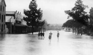
Photograph, Aug 1909
1909 flood, High Street, Charlton Victoria. Children standing in floodwater in High Street looking west from corner of Armstrong Street. Malcolm's Flour Mill and Proctors Double story building.B/W photograph of 1909 flood. Children standing in floodwater in High Street looking West from Corner of Armstrong Street Charlton.flood, charlton, armstrong street, arm -
 Federation University Historical Collection
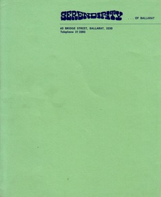
Document - Document - Letterhead, ZILLES COLLECTION: Letterhead for Serendipity of Ballarat
Zilles Printers was begun by Lewis Zilles in the early 1930s. It was in McKenzie Street Ballarat. His son Jeffrey also became a printer - letterpress, offset and screen printer. The business became Zilles Printers/Graphics and was in Armstrong Street and later Bell Street Ballarat.Bright green textured paper with navy blue printAddress: 62 Bridge Street Ballarat 3350zilles printers, ballarat, serendipity of ballarat -
 Federation University Historical Collection
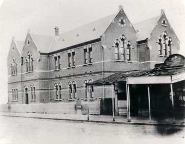
Photograph - Black and White, Humffray Street Primary School (no. 34), Ballarat East, 1876, 1876
The Humffray Street Primary School of opened on 10 January 1976.Double storey brick school in Humffray Street Ballarat East. It shows the Humffray Street frontage. humffray street primary school, education -
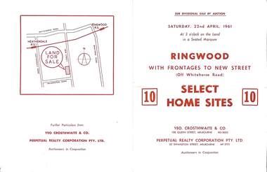 Ringwood and District Historical Society
Flyer, Auction sale brochure advertising home sites with frontages to New Street, Ringwood, Victoria - 1961
Advertisement for Sub-divisional sale by auction on Saturday, 22nd April, 1961, with terms of sale of 10 home sites with frontages to New Street, Ringwood, Victoria.Location map showing land for sale on New Street, Ringwood, north of Palmerston Road. Auctioneers in conjunction - Yeo, Crosthwaite & Co., 108 Queen Street Melbourne (Telephone) MU 8605, and Perpetual Realty Corporation Pty. Ltd., 62 Swanston Street, Melbourne (Telephone) MF 3721. -
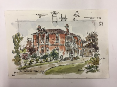 Kew Historical Society Inc
Work on paper, Joy Stewart, 63 Wellington Street, Kew, c. 1978
Sydney Joy (joy) Stewart (1925-2018) was a founding member of the Kew Historical Society, and during the 1970s its secretary. During her residence in Kew, she completed numerous property illustrations on commission. These ranged from preliminary sketches, including architectural details to finished pen & ink and wash illustrations on paper. On moving to Queensland, Joy Stewart donated the remaining property illustrations in her possession to the Kew Historical Society. In 1987-88, she fulfilled a commission by the Society of designs for a series of embroideries completed by residents during the Australian Bicentennial commemorations.Sydney Joy (Joy) Stewart was born in Melbourne 1925. She studied at Swinburne Technical College Art School from 1941-1945, then the National Gallery Art School 1946-1948. Her career included employment positions as a display artist, designer/painter, gallery assistant, and art teacher. Joy relocated to Cairns in 1981. Solo exhibitions in Melbourne and Cairns, including 'Done By Me' at Cairns Regional Gallery in 1999. Group exhibitions at Cairns Regional Gallery, 'The Fish John West Regrets, 1993' and 'Facets of Life' 1994. Joy Stewart died in Cairns in 2018.Watercolour, pen & Ink on paper by the artist and local historian Joy Stewart of a two-storey Victorian-era residence located at 63 Wellington Street, Kew. Inscription: "63 Wellington Street, Kew." Signed lower right: "JStewart".joy stewart, wellington street (kew) -
 Flagstaff Hill Maritime Museum and Village
Medal - Token, Richard Parker, ironmonger, Mid-to-late 19th century
This copper penny token was issued in Geelong by ironmonger R. Parker. Richard Parker was an early settler in Victoria. He had a general store in Elizabeth Street, then Collins Street, Melbourne for five years before moving to Geelong in 1844. He soon established several branches of his ironmonger business in towns around Victoria. He encouraged trade by providing customers with the small change of penny tokens in exchange for their more valuable and less convenient silver coins. The token carried a surcharge and was overstamped with the mane of W. Kernot. William Charles Kernot was a chemist at Chillwell, Geelong. The token is of historical significance, representing a form of currency used in Australia's colonial era before Australia had official currency.Token coin; a round copper one penny token. Obverse had promotional text and a sketch and was overstamped with a name. Reverse had the image of a woman holding up a set of balance scales in one hand and a cornucopia in the other, standing beside the sea, with a three-masted sailing ship in the background, There is a formed hole in the metal; on the obverse, it is on the top of the design, on the reverse it is on the bottom of the design. It advertises R. Parker, Ironmonger, Moorabool Street, Geelong, overstamped with the name W. Kernot.Embossed on the obverse: "R. PARKER / IRONMONGER. / MOORABOOL STREET / GEELONG" "W. KERNOT" Embossed on reverse: "AUSTRALIA"warrnambool, shipwreck coast, flagstaff hill, flagstaff hill maritime museum, flagstaff hill maritime village, medallion, coin, token, promotional medallion, one penny, r parker, ironmonger, moorabool street geelong, w. kernot, richard parker, currency, australian currency -
 Kew Historical Society Inc
Photograph - Kew Junction, Herald & Weekly Times, 1962
This is an aerial oblique image looking north. It shows Kew Junction before construction of VicRoads (Country Roads Board), Murphy's (Leo's) supermarket, and office towers. It also shows a building on the land now known as the Raoul Wallenberg Reserve, the Kew Municipal Offices in Walpole Street, and St Paul's School for the Blind in Fernhurst Grove, and Kew Bowling Club in Wellington Street.An aerial photograph of Kew Junction, showing the intersection of High Street South, Studley Park Road, Princess Street, High Street and Denmark Street. A number of buildings, now demolished can be identified in the photo, including Jellis’ Bakeries on the corner of Princess Street and Studley Park Road." Annotation on reverse: "Kew Historical Society from Mr L. H. Chinner".kew junction, aerial photograph (kew), oblique aerial, st paul's school for the blind, kew municipal offices, high street kew, studley park road, kew war memorial, kew post office, kew police station, kew court house, high street south, kew, wellington street kew, denmark street kew -
Glenelg Shire Council Cultural Collection
Photograph - Photograph - Julia Street Porrtland, c. 1970
Photographic print of a rephotographed photograph. Image of north side of Julia Street between Percy and Bentinck Streets. Bluestone buildings - Woolstores of Henty, Learmonth & Co, Bank of Australasia on right. Numerous people on footpath.Front: 'Henty Woolstore - 2 Observer Buildings, Julia Street' - green ink Back: 'Bayview and Observer Printers' - blue biro -
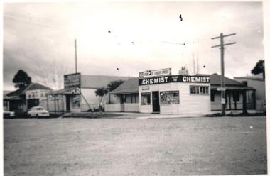 Hume City Civic Collection
Photograph, 1952
B/W photograph of a couple of single storey timber shops on the corner of Brook and Evans Street, Sunbury. Identified as Mr. Lloyd's Chemist shop, and residence, also Endall's Drapery shop. Taken in 1952.Handwritten on back: Mr Lloyd's Chemist shop, Sunbury and residence, also Endall's Drapery shop, 1952, corner of Evans Street, and Brook Street.lloyd, - (mr), lloyd's chemist shop, pharmacies, sunbury, endall's drapery, evans street, brook street, businesses, 1950s, george evans collection