Showing 4013 items
matching surveying
-
 Ringwood and District Historical Society
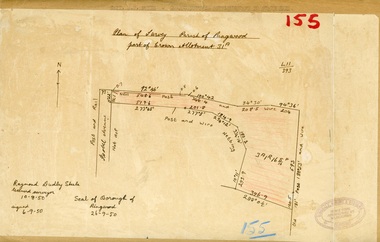
Map, Plan of Survey, Parish of Ringwood - Part of Crown Allotment 31A - 1950
Hand drawn and labelled copy of map with survey measurements of allotment on Isobel Avenue (Isabel Avenue?), Ringwood East. Raymond Dudley Steele Licensed Surveyor 10-8-50, signed 6-9-50, Seal of Borough of Ringwood 26-9-50. Rubber stamp - Dugdale, Simmons & Stevens, Solicitors, Peacock House, 486 Bourke Street Melbourne. Typewritten heading on backing paper - Capt. M.H. Moyes - Correspondence Supplementary to Statements. -
 Bendigo Military Museum
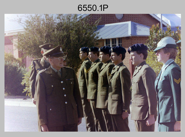
Photograph - 4th Field Survey Squadron OC’s Parades and Defence Force Service Medal Presentations, Keswick Barracks, Adelaide SA, 1988
This is a set of eight photographs of a 4th Field Survey Squadron OC’s parade at Keswick Barracks, Adelaide SA in 1988. The Colonel Commandant (honorary appointment) of the Survey Corps - COL Clem Sargent (retired) presented the Defence Force Service Medal to personnel in recognition of 15 years of efficient remunerated service, or the Clasp for 5 years of additional service. This is a set of eight photographs of a 4th Field Survey Squadron OC’s parade and the presentation of the Defence Force Service Medal, at Keswick Barracks, Adelaide SA in 1987. The colour photographs are on 35mm negative film and are part of the Army Survey Regiment’s Collection. The photographs were scanned at 96 dpi. .1) - Photo, colour, 1988. L to R: COL Clem Sargent (retired), SSM WO1 Bill Griggs & OC MAJ Peter Cates (obscured), SGT Stu Symonds, SPR Wally Twidale, CPL Jamie McRae, SPR Owen Jones, SPR Steve Ellis, CPL Michelle Griffith. .2) - Photo, colour, 1988. L to R: CPL Peter Tuddenham, COL Clem Sargent (retired), CPL Peter Hardy, SGT Wally Chilcott, CPL Terry ‘TJ’ Wicker (foreground), SPR Steve Nokes, SSGT R. Marsh. .3) - Photo, colour, 1988. L to R: SSM WO1 Bill Griggs (obscured), COL Clem Sargent (retired), CPL Jim Humphrey, unidentified, CPL John Ratcliffe, SGT Wally Chilcott, SPR Cheryl Deluca-Cardillo, SSGT R. Marsh, unidentified. .4) - Photo, colour, 1988. L to R: CAPT Danny Galbraith, COL Clem Sargent (retired), OC MAJ Peter Cates. .5) - Photo, colour, 1988. L to R: SGT Derek Stanmore, COL Clem Sargent (retired), OC MAJ Peter Cates. .6) - Photo, colour, 1988. COL Clem Sargent (retired) at the flagpole. L to R: SPR Cheryl Deluca-Cardillo, CPL Ken Peters, SPR Steve Ellis, SSGT R. Marsh, 2IC CAPT Terry Lord, CPL Michelle Griffith, SPR Steve Nokes, SSGT Dennis Learmonth, SGT Gill Park, unidentified. .7) - Photo, colour, 1988. COL Clem Sargent (retired) at the flagpole. L to R: SPR Owen Jones, SPR Cheryl Deluca-Cardillo, CPL Ken Peters, SPR Steve Ellis, 2IC CAPT Terry Lord, CPL Michelle Griffith, SPR Steve Nokes, WO2 Bob Rogister, SGT Gill Park, unidentified. .8) - Photo, colour, 1988. 4 Fd Svy Sqn OC’s Parade ‘standing at ease’..1P to .8P – There are no personnel identified. ‘1988 Presentations’ annotated on negatives sleeve.royal australian survey corps, rasvy, 4 fd svy sqn -
 Bendigo Military Museum
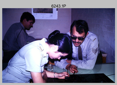
Photograph - Retouching Reproduction Material at the Army Survey Regiment, Fortuna, Bendigo, c1975
This is a set of seven photographs of technicians retouching orthophoto reproduction material at the Army Survey Regiment, Bendigo, c1975. Retouching mainly entailed the application of liquid opaque (Plumtree), commonly known as “duff” to cover blemishes such as scratches and spots on film negatives before photographic exposure. Retouching technicians also used specialised techniques such as “needling” to repair faults on the emulsion of map reproduction material. The technicians in this set of photos were probably working on the retouching and registration of orthophotomap colour film separations in preparation for publication by Print Troop. Peter Dew featuring in photos .1P to .5P was a serving member of RA Svy, who died in a tragic accident at home. He was fondly remembered as one of Lithographic Squadron’s colourful personalities. The "Super Animal of the Year" Peter Dew Memorial Award was an award presented to a member of the squadron for a crude act. To view a photo of this award, refer to item 6230 of the Victorian Collections.This is a set of seven photographs of technicians retouching and assembling orthophoto reproduction material at the Army Survey Regiment, Fortuna, Bendigo. c1975. The photographs are on 35mm colour slides and were scanned at 96 dpi. They are part of the Army Survey Regiment’s Collection. .1) to .3) - Photo, colour, c1975. Retouching reproduction material. L to R: SPR Ralph Chant, PTE Laurie Tedford, SGT Peter Dew. .4) to .5) - Photo, colour, c1975. Retouching reproduction material. SGT Peter Dew. .6) - Photo, colour, c1975. Assembly of orthophoto colour film separations. .7) - Photo, colour, c1975. Assembly of orthophoto colour film separations, CPL Garran Hill..1P to .7P - There are no annotations stored with the 35mm slides.royal australian survey corps, rasvy, army survey regiment, army svy regt, fortuna, asr, litho -
 Bendigo Historical Society Inc.
Map - FORTUNA HUSTLER'S MINE - PLAN OF THE FORTUNA HUSTLER'S MINE
Plan of the Fortuna Hustler's Mine, Bulletin No 33, Plate No II. Geological Survey of Victoria. Signed by H A Whitelaw, Underground Survey Office Bendigo, September 1913. Map shows levels and depths. There are smaller drawings of some sections of some levels. This item has not been scanned or photographed.mining, parish map, fortuna hustler's mine, plan of the fortuna hustler's mine, geological survey of victoria, h a whitelaw, underground survey office bendigo -
 Bendigo Historical Society Inc.
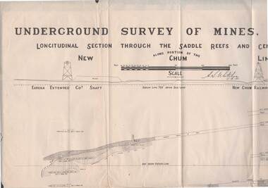
Map - STRUGNELL COLLECTION: NEW CHUM LINE OF REEF, 5/4/01
Map, Along portion of the New Chum Line, Underground Survey of Mines, Bendigo, Longitudinal Section through the Saddle Reefs and Centre Country. Eureka Extended Co's shaft, New Chum Railway Co's shaft. Surveyed under the supervision of H.Herman, B.C.E., F.G.S., Acting Government Geologist.H.S.Whitelowmap, bendigo, new chum line -
 Whitehorse Historical Society Inc.
Map, Melbourne Metropolitan Area Base Map series. Sheet 214, c1960
Map showing northern section of the City of Nunawading together with parts of Shire of Doncaster and Templestowe.Map showing northern section of the City of Nunawading together with parts of Shire of Doncaster and Templestowe. Shows roads, creeks, block numbers and contours at 5 feet vertical increments. Note on map: 'prepared ... from State Aerial Survey, January 1957 and Cadastral Survey information February 1959'.Map showing northern section of the City of Nunawading together with parts of Shire of Doncaster and Templestowe. maps, city of nunawading, shire of doncaster and templestowe -
 Bendigo Historical Society Inc.
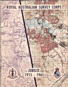
Document - AULSEBROOK COLLECTION: ROYAL AUSTRALIAN SURVEY CORPS JUBILEE 1965, 1965
Aulsebrook Collection: two pamphlets relating to a Jubilee events at the Royal Australian Survey Corps. Title: Royal Australian Survey Corps, Jubilee 1915-1965 (x 2 pamphlets) Two pamphlets for same event, A5, colourful map on the front of the booklet, -First pamphlet is a dinner and wine menu for Jubilee event -Second pamphlet is a information booklet on a brief history of the Corps, and a list of ranks and individuals in the Survey Corps. Booklet also has some photos of Fortuna where the Corps is. -
Bendigo Historical Society Inc.
Map - YALLOOK : COUNTY OF BENDIGO, 1957
Map. Yallook, County of Bendigo, Talambe, Neilborough, Yarraberb, Salisbury, Pompapiel. Drawn and reproduced at the Department of Lands and Survey, Melbourne,1957. Distances shown on the plan are derived from original surveys of varying dates and whilst approximately correct do not necessarily conform to modern standards of accuracy. For survey information application should be made to the central plan office, or to the office of titles. Some ink scibbles appear at the right top of this map. Price 2/-. (number 14 in map cupboard 1)By Authority W.M.Houston, Govt.Printer,Melbourne.map, bendigo, yallook -
Kew Historical Society Inc
Archive (Sub-series) - Subject File, Barnard Grove (Kew), 1985
Dorothy Benyei & Rosemary SmartReference, Research, InformationKHS OrderSubject file containing responses to a survey of residents of Barnard Grove, Kew (Vic), issued in 1985. The questionnaire requested information about when the respondee/s moved into the street, whether alterations had been made to their house, the reason why they moved to Barnard Grove, its good points and its limitations, and further comments. Rosemary Smart and Dorothy Benyei conducted the survey on behalf of the Society. The file contains many interesting responses from those who returned the surveys.barnard grove - kew east (vic.)barnard grove - kew east (vic.) -
 Bendigo Historical Society Inc.
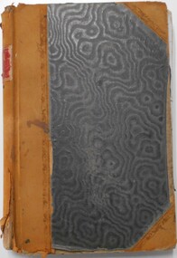
Document - LANDS OFFICE - CROWN LANDS SURVEYED AND SOLD SANDHURST, 1860 onwards
Journal: LANDS OFFICE - CROWN LANDS SURVEYED AND SOLD SANDHURST green hard cover journal with buff spine and corners. Contains details of crown land surveyed and sold in the district of Sandhurst. Indexed in front by parish, alphabetical double pages not numbered. On LH page, parish, town, suburban, country, date of survey. On RH page, date of sale, auction, selection, price, total amount, purchaser. On spine ' index book' 'F' and '09'. Dated from 1860 onwardsLands Officeland sales, bendigo -
 Bendigo Military Museum
Photograph - Army Survey Regiment – Presentation to Charity Organisation, 1984
These photographs of a presentation to a charity organisation were taken in the grounds of Fortuna Villa, Army Survey Regiment in 1984. SPR Tracy (Parker) Ash was the unit’s Miss Golden North section entrant in the Miss Australia Quest. MAJ Bob Roche, RSM Bob Mason and SPR Parker presented a fundraising cheque to the unidentified representative from the Spastic Society. The the newspaper article is from the Bendigo Advertiser. The following wording is taken from the article: ‘Tracy Parker is a sapper in the Army, and a cartographic technician stationed at Fortuna, Bendigo. Originally from Melbourne, Tracy, 23, is the latest entrant in the Miss Golden North segment of the Miss Australia Quest. The highlight of Tracy’s quest will be an open day at Fortuna, once the magnificent home of Bendigo’s Quartz King, George Lansell. This open day at Fortuna, on Sunday, August 26, between 10 am and 4 pm, will give district residents a rare opportunity of inspecting this magnificent building and its gardens. Tracy said there will be handicrafts, rides, competitions and refreshments available at the open day. The main attraction, apart from the building and gardens, would be a hot air balloon. Admission to the open day would be: Adults $2, children and pensioners $1, family party $5. All proceeds from the open day at Fortuna will go to the Spastic Society. Tracy, like all other Miss Australia candidates work hard for the Spastic Society in fundraising activities. Getting further involved in fundraising, Tracy and her strong committee have organised a 6km fun run for Sunday August 19. Entry forms are available at Bendigo sports stores, and at the end of the fun run will be a barbecue. Apart from her vocation in the Army, and fundraising for the Spastic Society, Tracy Parker has a great love of horses, and associated activities of riding, jumping and showing her horses. Tracy is keen to do well in her fundraising, and with the Australian Army, or more particularly, the ranks of Fortuna behind her, Tracy looks like succeeding.’The first three items are photographs of a presentation to a charity organisation at the Army Survey Regiment, Bendigo in 1984. The fourth item is an article from the Bendigo Advertiser describing Army Survey Regiment’s fund-raising activities. The photographs were printed on photographic paper and are part of the Army Survey Regiment’s Collection. The photographic proof prints were scanned at 600 dpi. Photos .1P and .2P were scanned at 300 dpi. The newspaper article was scanned at 762 dpi. .1) to .3P) - Photo, black & white, 1984, L to R: MAJ Bob Roche, Regional Coordinator Mrs Jan Lamborn, SPR Tracy (Parker) Ash, RSM WO1 Bob Mason. .4) – Bendigo Advertiser newspaper article with photo, black & white, 1984, SPR Tracy (Parker) Ash. .1P to .2P – ‘Presentation of Certificate of Appreciation from Spastic Society. Presented by Regional Coordinator Mrs Jan Lamborn to MAJ Roche, SPR Tracy Ash (entrant in Miss Australia Quest (1984) and WO1 Mason.' .3P – No personnel identified. .4P – SPR Tracy Parker named in newspaper article.royal australian survey corps, rasvy, army survey regiment, army svy regt, fortuna, asr -
 The Beechworth Burke Museum
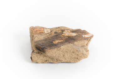
Geological specimen - Yellow Sandstone
This specimen is from Barefoot Hills, Victoria. Sandstones are economically important as major reservoirs for both petroleum and water, as building materials, and as valuable sources of metallic ores. Most significantly, they are the single most useful sedimentary rock type for deciphering Earth history. This specimen is part of a larger collection of geological and mineral specimens collected from around Australia (and some parts of the world) and donated to the Burke Museum between 1868-1880. A large percentage of these specimens were collected in Victoria as part of the Geological Survey of Victoria that begun in 1852 (in response to the Gold Rush) to study and map the geology of Victoria. Collecting geological specimens was an important part of mapping and understanding the scientific makeup of the earth. Many of these specimens were sent to research and collecting organisations across Australia, including the Burke Museum, to educate and encourage further study.A sedimentary rock composed mostly of quartz sand. Sandstone is the second most common sedimentary rock after shale. Sandstones consist of sand-sized grains principally quartz, feldspar and rock fragments. The two major classes of sandstone are arenite and wacke. the colour of sandstone varies from grey, yellow, red and white reflecting the variation in mineral content and cement and is gritty to touch (like sandpaper).Geological survey / R.... S 61 / Loc Bareboot Hills / Sheet / 24SE / 94 /burke museum, beechworth, indigo shire, beechworth museum, geological, geological specimen, mineralogy, sandstone, yellow sandstone, victoria, barefoot hills -
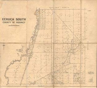 Bendigo Historical Society Inc.
Map - JACK FLYNN COLLECTION: ECHUCA SOUTH, 13/08/1931
Map: Parish of Echuca South, County of Rodney. Parish plan.By Authority H. J. Green, Govt. Printer. Department of Lands and Survey, Melbourne. 13.8.31map, rodney, parish plan, echuca south , county of rodney -
 Bendigo Historical Society Inc.
Map - JACK FLYNN COLLECTION: KARA KARA, 1932
Map: County of Kara Kara, map sheet showing the whole of the County of Kara Kara and all of the Parishes within. Scale 2 miles to 1 inch.By Authority: W.M. Houston, Government Printer Melbourne. Department of Lands and Survey, Melbourne, 1958map, kara kara, county, kara kara -
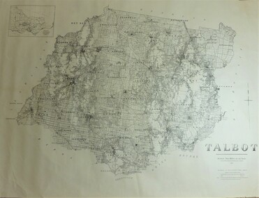 Bendigo Historical Society Inc.
Map - JACK FLYNN COLLECTION: TALBOT, 1937
Map: County of Talbot, map sheet showing the whole of the County of Talbot and all of the Parishes within. Scale 2 Miles to 1 inch.By Authority: A.C. Brooks, Government Printer, Melbourne. Department of Lands and Survey Melbourne. 1959map, talbot, county, talbot -
 Bendigo Historical Society Inc.
Map - JACK FLYNN COLLECTION: COUNTY OF GLADSTONE, 1934
Map: County of Gladstone, map sheet showing the whole of the County and the Parishes within. Scale 2 Miles to 1 inch.Engraved at the Department of Lands and Survey Melbourne. 1958. By Authority of W.M. Houston, Government Printermap, gladstone, parish plan, gladstone -
Stawell Historical Society Inc
Map, Department of Crown Lands and Survey Victoria, Allotments in the Township of Banyana. Parish of Burrum Burrum. 1946 / 1971, 1971
Richardson River. Avon River JunctionPaper Map of County of BorungReprint of the 1946 edition. Drawn and reproduced at the Department of Crown Lands and Survey Victoria 1971.survey -
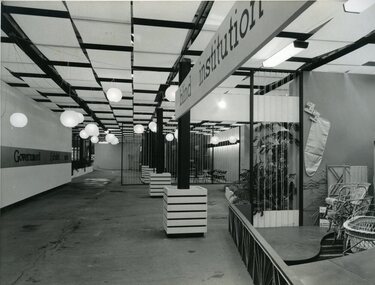 Vision Australia
Photograph - Image, Queensland Blind Institution display at exhibition, 1962?
Part of a display by the Queensland Blind Institution (?) as part of a exhibition. Neither the full name of the organisation nor the exhibition are known, however a sign on the opposite wall reads "Government Exhibit 1962". Cane chairs, an ironing board cover, coat hangers, a cane cot and a cane screen are viewable to the far right of the image. The remaining view is of an empty space awaiting exhibitors.1 x B/W photograph of exhibition spaceC2-4138 Reproduced by Photo Section, Survey Office, Dept. Public Lands, QLD.queensland industrial institute for the blind, fundraising -
 Bacchus Marsh & District Historical Society
Map, Plan of land purchased by the Bacchus Marsh Shire Council from Mr. T. Low for a deviation of the Melbourne to Ballarat main road. 1877
The date of this plan is 1877 and the land indicted on it required for a road deviation is shaded in blue. It adjoins the Korkuperrimul Creek on one side which indicates the land is located just a few kilometers to the west of Bacchus Marsh. Single page map showing a portion of land purchased by the Bacchus Marsh Shire from Mr Thomas Low for the purpose of a road deviation. Land held by David Robertson is also shown on the map. Scale: 2 chains to 1 inch. Part of a set of maps which are pasted into a bound volume containing 76 maps or plans in total. High resolution digital image stored on BMDHS computer network. Surveyed by W. E. Standfield, Shire Engineer, Bacchus Marsh, 12/4/77bacchus marsh roads and streets, melbourne to ballarat road -
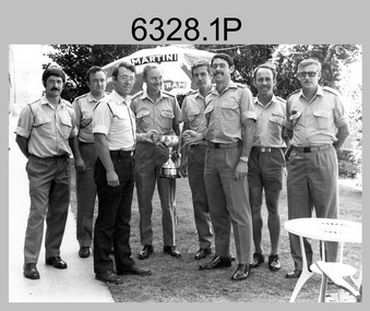 Bendigo Military Museum
Photograph - Army Survey Regiment’s Rifle Shooting Team, Fortuna, Bendigo, c1979
This set of 10 photographs of the Army Survey Regiment’s victorious rifle shooting team was taken outside the Tavern at Fortuna, Bendigo in c1979. The rifle shooting competition was the ‘Irwin Trophy for Shooting’, a contest with the British Army’s 42nd Engineer Regiment, the equivalent military geographic mapping unit at the time to the Army Survey Regiment. The bent .303 rifle seen in photo .3P was retrieved from the bottom of Fortuna’s lake when it was drained for restoration. It is believed an excavator drove over the rifle before it was retrieved.This set of 10 photographs of the Army Survey Regiment’s rifle shooting team was taken at Fortuna, Bendigo in c1979. The photographs were printed on photographic paper and are part of the Army Survey Regiment’s Collection. The 35mm positive photographic proofs were scanned at 600 dpi. Larger prints of .1P, .3P and .10P were scanned at 300 dpi. .1) & 2) - Photo, black & white, c1979, Rifle Shooting Team - L to R: Warren ‘Waldo’ Shirley, John Waight, Peter Searle UK Exchange, CO LTCOL Bob Skitch, Jim Macdonald, John Harrison, Max Neil, Stan Vote. .3) - Photo, black & white, c1979, Rifle Shooting Team - L to R: Stan Vote, John Harrison, Max Neil, Warren ‘Waldo’ Shirley, Jim Macdonald, John Waight. .4) - Photo, black & white, c1979, Rifle Shooting Team - L to R: CO LTCOL Bob Skitch, Jim Macdonald, Stan Vote. .5) - Photo, black & white, c1979, Rifle Shooting Team - L to R: John Waight, Warren ‘Waldo’ Shirley. .6) - Photo, black & white, c1979, Rifle Shooting Team - L to R: Warren ‘Waldo’ Shirley, CO LTCOL Bob Skitch. .7) - Photo, black & white, c1979, Rifle Shooting Team - L to R: CO LTCOL Bob Skitch, Warren ‘Waldo’ Shirley, Stan Vote, Jim Macdonald, Max Neil. .8) - Photo, black & white, c1979, Rifle Shooting Team - L to R: Jim Macdonald, Max Neil, Stan Vote. .9) - Photo, black & white, c1979, Rifle Shooting Team - L to R: CO LTCOL Bob Skitch, Peter Searle UK Exchange, Warren ‘Waldo’ Shirley. .10) - Photo, black & white, c1979, Irwin Trophy for Shooting..1P to .10P –No personnel are identified.royal australian survey corps, rasvy, army survey regiment, army svy regt, fortuna, asr -
 Bendigo Historical Society Inc.
Map - GREAT EXTENDED HUSTLER'S MINE - PLAN OF THE GREAT EXTENDED HUSTLER'S MINE
Plan of the Great Extended Hustler's Mine. Bulletin No 33, Plate No XI. Shows No 2 Shaft, Latham & Watson's Shaft, levels and their depths and some geographical features. Geographical Survey of Victoria emblem and signed by H A Whitelaw, Underground Survey Office, Bendigo, September 1913. Has reference to photos.mining, parish map, great extended hustler's mine, no 2 shaft, latham & watson's shaft, geological survey of victoria, underground survey office bendigo, h a whitelaw -
Bendigo Historical Society Inc.
Map - UNITED HUSTLER'S & REDAN MINE - TRANSVERSE SECTIONS N & S OF SHAFT UNITED HUSTLER'S & REDAN MINE
Transverse Sections N & S of Shaft United Hustler's & Redan Mine on the Hustler's Line of Reef Bulletin No 33, Plate No XXX. Map shows some of the stone encountered on the levels and depth. Geological Survey of Victoria emblem and signed by H A Whitdan, Underground Survey Office Bendigo, September 1913.mining, parish map, united hustler's & redan mine, transverse sections n & s of shaft united hustler's & redan mine, hustler's line of reef -
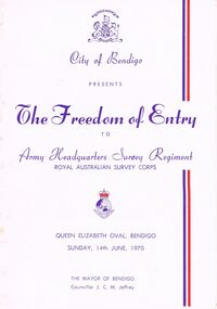 Bendigo Historical Society Inc.
Document - LYDIA CHANCELLOR COLLECTION; THE FREEDOM OF ENTRY PROGRAMME
A white programme with red and purple print. The front cover contains the words ' City of Bendigo Presents The Freedom of Entry to Army Headquarters Survey Regiment Royal Australian Survey Corps. Queen Elizabeth Oval, Bendigo Sunday, 14th June, 1970. The Mayor of Bendigo Councillor J.C. M. Jeffrey.'program, music, royal australian survey corps, lydia chancellor, collection, program, programme, the freedom of entry, royal australian survey corps., event, entertainment, music, ephemera -
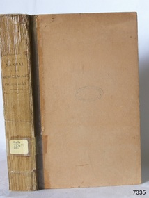 Flagstaff Hill Maritime Museum and Village
Book, Manual of the New Zealand Coleoptera
Manual of the New Zealand Coleoptera Author: CaptainThomas Broun Publisher: Colonial Museum and Geological Survey dept Date: 1880Label on spine with typed text RH 595.76 BRO Inside front cover has a sticker that reads Warrnambool Mechanics Institute and Free Library warrnambool, shipwrecked-coast, flagstaff-hill, flagstaff-hill-maritime-museum, maritime-museum, shipwreck-coast, flagstaff-hill-maritime-village, shipwrecked-artefact, book, manual of the new zealand coleoptera -
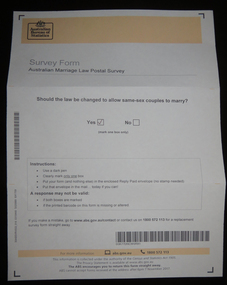 Federation University Historical Collection
Document, Australian Marriage Law Survey, 2017, 12/09/2017
The vote was made online, so the paper vote papers were kept and donated. Letter from Australian Statistician David W. Kalisch regarding the Australian Marriage Survey, and a photograph of the ballot paper and envelope.australian marriage law, marriage equality, australian bureau of statistics, gay marriage, same sex marriage -
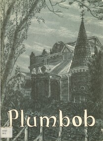 Bendigo Historical Society Inc.
Book - PLUMBOB, 1968
Plumbob. The unit magazine of AHQ Survey Regiment Bendigo, which was located at Fortuna. Vol 1 No 2 Dec 1968bendigo, history, fortuna and survey reg. -
 Bendigo Historical Society Inc.
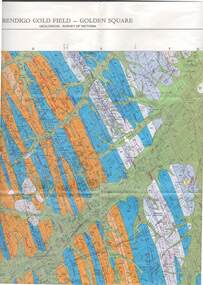
Map - STRUGNELL COLLECTION: GEOLOGICAL SURVEY OF VICTORIA, BENDIGO GOLD FIELD - GOLDEN SQUARE, 1992
Map, Geological Survey of Victoria, Bendigo Gold Field - Golden Square, Campaspe 10 000/2.2. Victoria 10,000.Dept. 0f Manufacturinf & Industry Development.map, bendigo, golden square gold field -
 Bendigo Historical Society Inc.
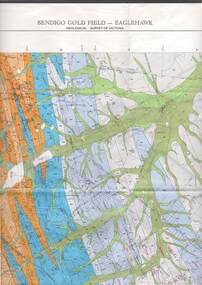
Map - STRUGNELL COLLECTION: GEOLOGICAL SURVEY OF VICTORIA, BENDIGO GOLD FIELD - EAGLEHAWK, 1992
Map, Geological Survey of Victoria, Bendigo Gold Field - Eaglehawk.Campaspe10 000/2.3; Victoria 1:10,000. Index of Shafts.Dept. of Manufacturing & Industry Developmentmap, bendigo, eaglehawk gold field -
Port Melbourne Historical & Preservation Society
Letter - Lands & Survey Office re permission to use land for football ground, 13 May 1880
Letter from Lands & Survey Office granting permission for use of land as per tracing sheet for football ground, 1880sport - australian rules football, sport - recreational grounds, peter gallienne grut, port melbourne football club, pmfc -
Bendigo Historical Society Inc.
Map - WESTON, 21/10/1876
Map: Re-Survey of part of the parish of Weston, County of Rodney. Parish plan (number 309 in map cupboard 1)Murray and Hargreave, Authorised surveyorsmap, rodney, parish plan, parish of weston, murray and hargreave